
Ascent Passport
I. Ascent category: rock climbing 2. Ascent area: Caucasus, 2.8, Midagrabindon river gorge 3. Peak, route: "3836", East ridge, 3rd category 4. Estimated category of difficulty: 2A, partially rocky 5. Route characteristics: Elevation gain — 580 m Route length — 1200 m Section lengths:
- Category 3 — 46 m
- Category 2 — 110 m Average steepness of the main route part — 45°
- Pitons hammered: 1 rock piton
- Total climbing hours/days — 8/1
- Number of overnight stays: two at a bivouac
- Team leader: Glazov Alexander Petrovich — Master of Sports
Team members:
- Tsevkovsky Yuri Vasilievich — Candidate Master of Sports
- Bogdanov S. — 3rd sports category
- Tebiev Z. — 3rd sports category
- Gorounov A.I. — 2nd sports category
- Gorbunov A.A. — 3rd sports category
- Slivko A. — 3rd sports category
- Pekhtelev V.A. — 3rd sports category
- I.O.
- Coach: Levkovsky Yuri Vasilievich — Candidate Master of Sports II. Departure on the route: October 4, 1998 Return to bivouac: October 4, 1998
- Organization: KAM FARSO-A
View from the North
 Taken with a telephoto lens from the summit of Tbau-khokh (Rocky ridge)
 Taken from the moraine of the cirque (October 1998)
 View from the North-East
In preparation for the ascent, a preliminary reconnaissance of the approaches to the summit was conducted visually and using a map, consultations were held, photographs were taken, and principles for ensuring radio communication were determined. It was established that the best radio communication is established with Vladikavkaz — there is a direct line of sight from the route: VHF radio station.
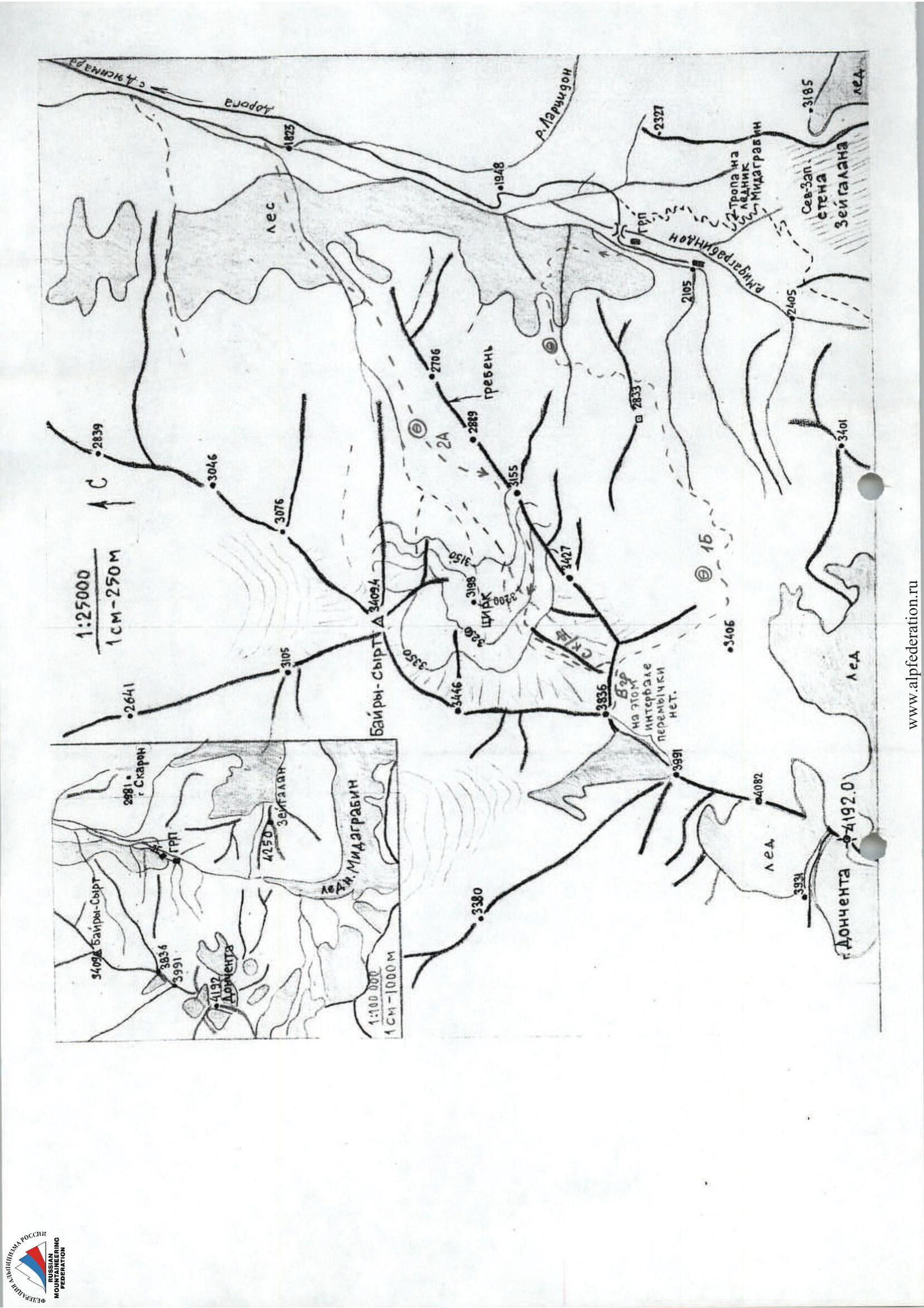
Approach to the route
Drive to the village of Jimara:
- by regular bus
- preferably by car to GRP from Vladikavkaz along a good road — 1.5–2 hours.
From GRP, turn right, cross the Midagrabindon river, and move towards the stream flowing from the cirque of peak 3836. Ascend on the right side of the stream (in the direction of travel) through the forest, along steep grassy slopes with a steepness of 45–50° and rock outcrops — 2–2.5 hours. When exiting the forest:
- traverse left to the stream, water;
- from the stream, move straight up to the cirque. Bivouac, no water, possible snow in spring-autumn period. From GRP — 3.5–4 hours.
Brief overview of the climbing area
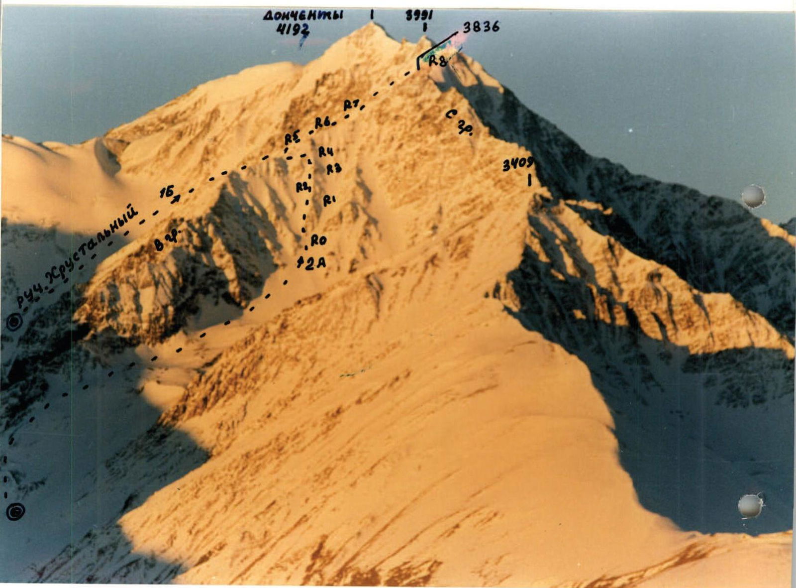
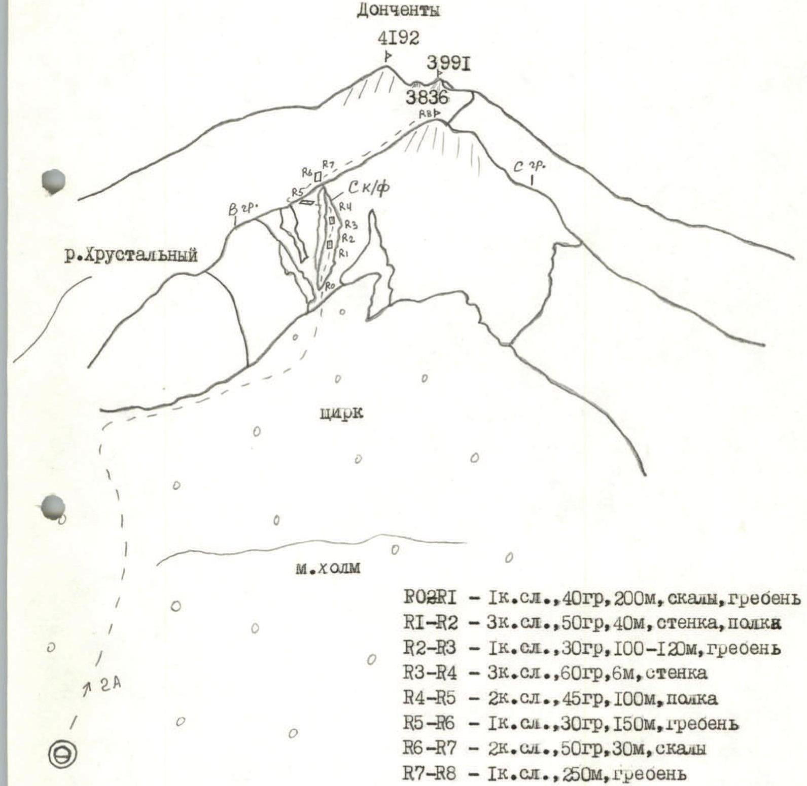
The ascent area is located in the eastern part of the Central Caucasus in the Midagrabindon river basin. The peak "3836 m" is located in the northern ridge of Donchenty peak (4192 m) and is a nodal point, to which, in addition to the ridge going south to Donchenty peak, two other ridges converge:
- Northern
- Eastern They form an extensive cirque of an extinct glacier, filled with moraines and scree, and located at an altitude of 3100–3200 m. The peak offers a panoramic view of the Midagrabin plateau, Shaukhokh peak (4713 m), and others. Signs of human presence were found on the peak, likely surveyors, and on the eastern ridge, cairns built by them were discovered. Previously, an ascent was likely made from the side of the Khrustalny river cirque, presumably of category 1 difficulty. The peak itself and the ridges are composed of heavily weathered schist rocks.
Route description
From the bivouac, move straight up along a gentle grassy slope towards the large moraine. Go around it on the left (in the direction of travel) and reach the saddle of the Eastern ridge of peak 3836. Traverse the Eastern ridge from the right side along the moraine scree, approach a series of counterforts descending into the upper cirque from the Eastern ridge of peak 3836. From the bivouac — 3 hours. Ascend 200–250 m along a steep fine scree to the middle counterfort, or possibly to the left counterfort and then move to the middle counterfort. Move along the counterfort ridge through несложным скалам and scree for 200 m to the 1st pillar.
- Along a ledge, category 3, 50°, 40 m to the left
- Then up the wall, category 2, 60°, 5 m to the top of the pillar. 100–150 m to the 2nd pillar, which is approached head-on along the wall, category 3, 60°, 5–6 m. Turn left, along a long rocky-scree (possible snow-ice) ledge, category 2, 45°, 100 m traverse under the rocks to reach the Eastern ridge. Along the Eastern ridge, in the middle section, несложные скалы, category 2, 50°, 100 m, ascend to peak "3836 m". From the moraines in the upper cirque — 3–4 hours. Scree:
- Frozen on the counterforts
- With snow Descend along the ascent route or into the neighboring Khrustalny river cirque.
Comments
Sign in to leave a comment