Description of the Ascent Route to Arkhon Glavny (4253 m) via the Northeast Ridge, Category 3B Complexity
The Arkhon massif is located in the Tepli group of peaks in the Northeast spur of the Kolota peak (4168 m). Its four peaks, listed in order from Kolota, are named:
- Yuzhny (South)
- Tsentralny (Central)
- Glavny (Main)
- Maly (Small)
The first ascent of Glavny Arkhon was made on July 2, 1949, by a group led by Senior Lieutenant German. On July 3, 1949, the ascent was repeated by a group of climbers from the Ordzhonikidze "Medik" Sports Society (led by A. Kalmykov). These ascents were made from the Khardadzhin glacier from the south and are classified as Category 2A. On May 29, 1966, a group of climbers from Ordzhonikidze, led by R. Proskuryakov, made the first ascent of the Northeast ridge of Arkhon Glavny, approaching it from the Kurtatin valley. The group consisted of athletes with 1st sports rank and one with 2nd sports rank.
On the same day, a group of third-rank climbers led by N. Alchiev made the first ascent of Arkhon Maly (3942 m) via the Southwest ridge, Category 2B complexity.
Day One
From Ordzhonikidze, travel through the village of Dzuarikau to the Kurtatin valley until the fork of the Fiagdon and Dzamarash-don rivers (2 hours 30 minutes). At the fork, cross the Fiagdon River to the left bank and follow the trail for about 1 km along the river. The trails lead into the first valley to the west.
Steep grassy slopes and scree lead to an ancient left-bank moraine hill. After 3 hours of walking, the ridge of this hill leads to the upper cirque of a vanished glacier.
At the junction of the moraine ridge and the slope, on a gentler slope, set up a bivouac (in spring, this area is not safe due to the risk of avalanches). The bivouac is approximately at 3000 m.
Day Two
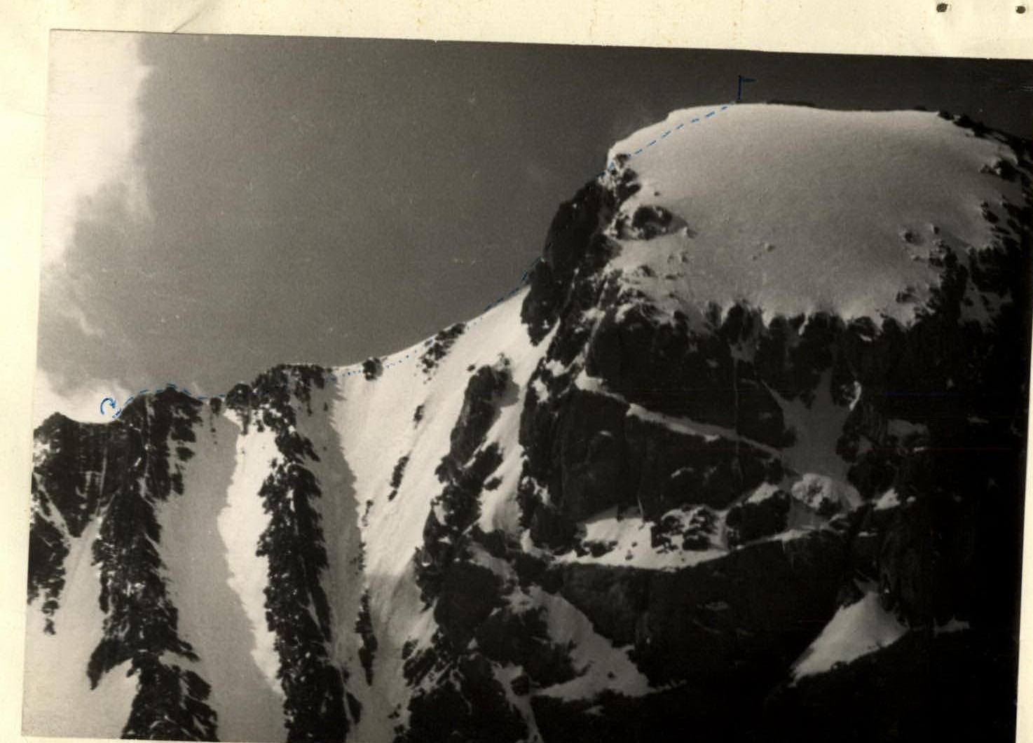
Early departure. Traverse the slope towards the Glavny Arkhon massif, visible ahead, gradually climbing up to the right along the snowy slope. Reach the spur in 1.5–2 hours. Follow the narrow snowy ridge of the spur, with cornices to the right and несложными скальными взлётами (simple rock climbs), in a rope team with mutual belay. After 1.5 hours, reach the junction of the spur with the Northeast ridge of Glavny Arkhon. From here to the tower of the Main peak, move along the narrow, knife-edge ridge with cornices on both sides. It's better to move onto the 45–50-degree Southeast slope of the ridge and traverse it with belay via an ice axe. The ridge is similar to the North ridge of Donguz-Orun. In places, near rock outcrops, sections of regelation ice may be encountered under the snow. The ridge is about six 40-meter rope lengths long.
The ridge leads to a rocky gendarme before the tower, 4–5 meters high, which is overcome directly.
An extremely narrow snowy "knife" connects the gendarme to the tower of the peak. It abuts against the wall of the tower, and a step is cut into it for the ascent. Belay via the gendarme's outcrop.
The general direction of movement up the 70-meter wall of the tower is to the right and upwards, following the left-hand edge of a poorly defined steep gully that drops off onto the North wall of the massif.
The tower of Glavny Arkhon is composed of light-colored, once fractured and cemented rocks with minor fracturing, making it difficult to organize belays. However, a few narrow cracks for piton placement can be found on the route (using pitons with thin blades).
After climbing the wall for one rope length, at a point where the gully widens, cross it on dense snow (55° steepness), then climb onto the rocks of the right-hand edge of the couloir and continue straight up a 45° snowy "spot" to a severely degraded rock ascent, which leads under a snowy cornice overhanging the wall of the tower. Make a clearing in the cornice (piton belay!) and climb onto the extensive snow-ice slab of the peak, sloping down to the northwest. The wall is overcome by the group in 2.5–3 hours.
The overall steepness of the 70-meter wall is significant, the rocks are unstable, and there's considerable psychological strain due to the climbing route passing over walls and slopes of the kilometer-long North wall of Arkhon.
The slab, covered in deep snow, becomes icy by the end of summer. Its steepness is 35°, easing to 30° towards the peak. When moving across it, avoid approaching the edge of the tower due to large snowy cornices hanging over the walls.
About 200 meters along the slope leads to the degraded rocks of the Glavny Arkhon peak.
Descent from the peak is possible via the ascent route using sports rappels or carabiner descents on a rope, down the wall of the tower, or along the simpler Southwest ridge to the Khadagdjin glacier and further into the Fiagdon valley.
Descent via the ascent route takes about 2–2.5 hours to the junction of the Northeast ridge and the spur, an additional 1–1.5 hours to the bivouac, and a further hour to the fork of the Fiagdon and Dzamarashdon rivers.
From here, return to Ordzhonikidze by car in 2–2.5 hours.
Equipment required for a group of 4:
- Main ropes, 40 meters — 2 pieces
- Repschnur for loops — 4 ends
- Group carabiners — 10 pieces
- Rock pitons — 10 pieces
- Ice pitons — 2 pieces
- Hammers — 2 pieces
The description was compiled by R. Proskuryakov 
MAP OF THE TEPLI REGION 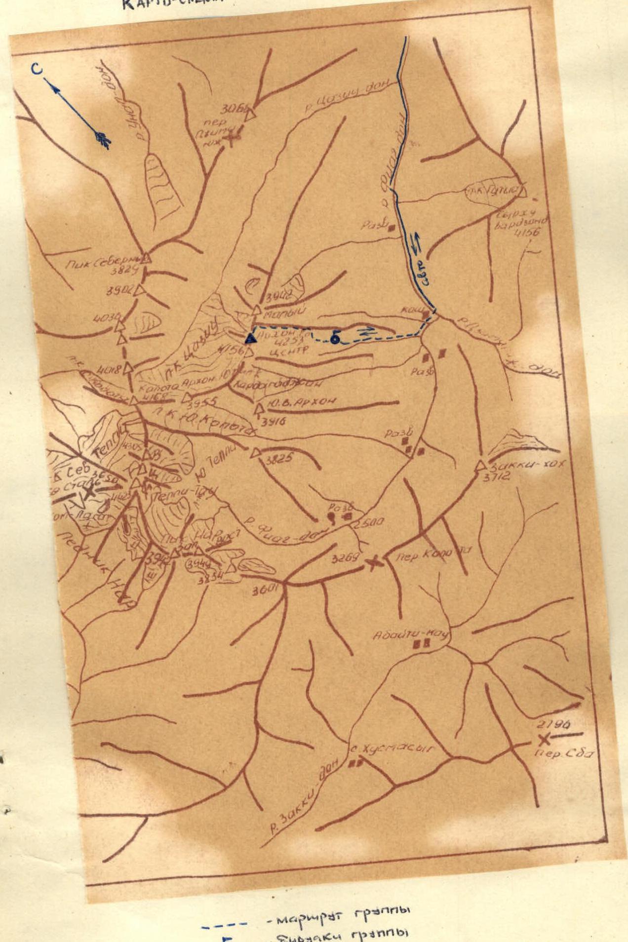
Arkhon Glavny (4253 m). View from the northwest. Route via the Northeast ridge, Category 3B complexity. Telephoto by R. Proskuryakov.