Ascent Passport
- Caucasus, Rocky Range, classification section number - 2.8.
- Kuardjin Tsentr. (2600 m) - Araukhoh Tsentr. (2550 m); traverse.
- Proposed 3A category of difficulty; first ascent.
- The nature of the route is rocky.
- The height difference of the route is up to 150 m.
The length of the route is 2200 m. The length of sections with 5 category of difficulty - 2 m. The average steepness of the key sections of the route is 60°. The average steepness of the entire route is 20°.
- Hooks left on the route - 2.
- Team's working hours - 8, days - 2.
- Leader: Egorin Sergey Vladimirovich - MS
Team members:
- Bondarenko Sergey Olegovich - 2nd sports category
- Zaivenko Igor Vyacheslavovich - 3rd sports category
- Zevakhin Gennady Yuryevich - CMS
-
Coach: Egorin Sergey Vladimirovich - MS
-
Exit to the route: 17:00, May 13, 2000.
Reaching the summit:
- Kuardjin Tsentr.: 18:30, May 13, 2000.
- Kuardjin Uzlovoy: 7:30, May 14, 2000.
- Araukhoh Tsentr.: 12:00, May 14, 2000.
- Return to base camp: 14:00, May 14, 2000.
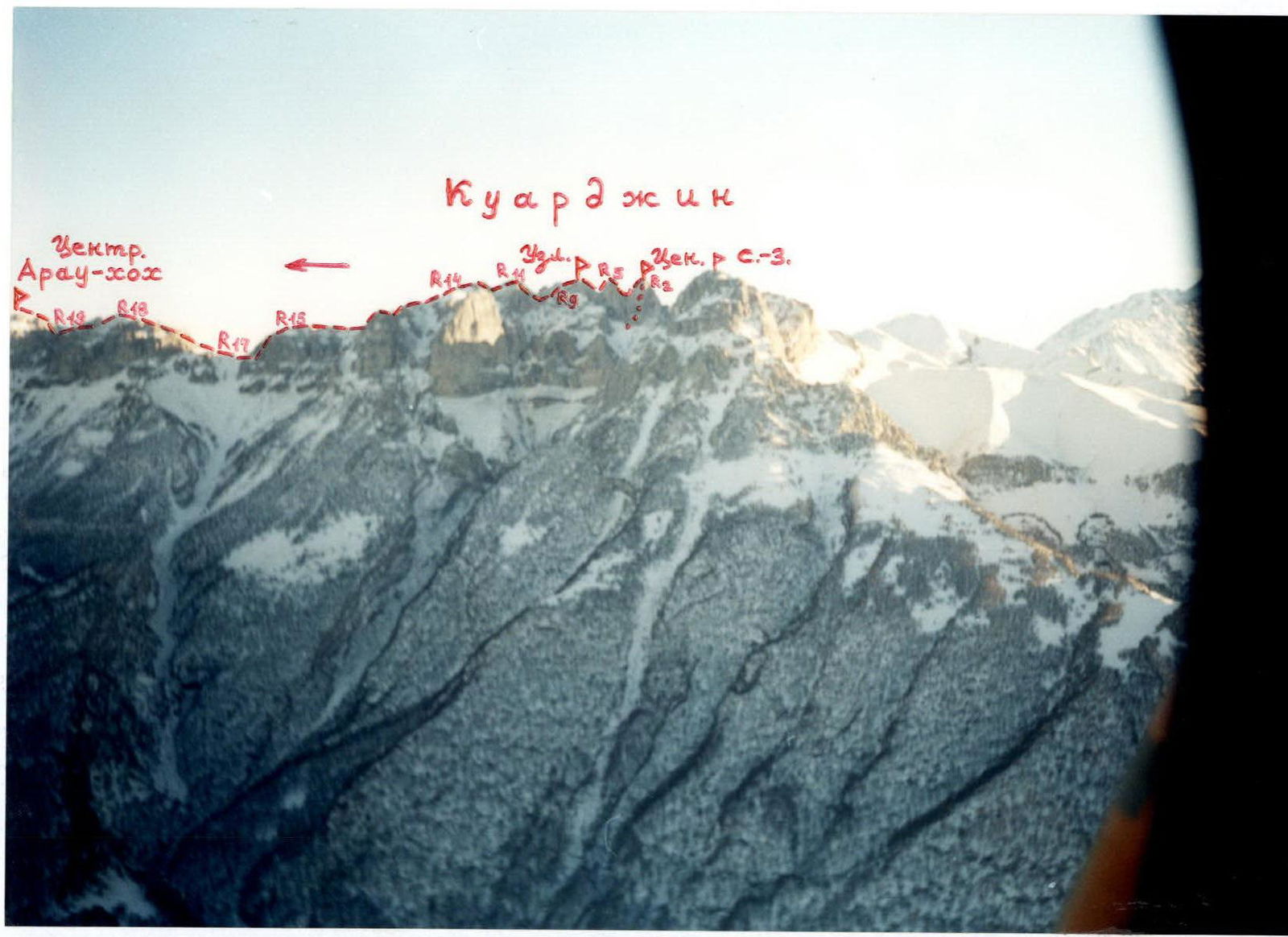
General view from the north to the Kuardjin and Araukhoh Tsentr. ridge. Photo taken from a helicopter, January. The path of the first ascent is marked.
Preparation for the Ascent
Before the ascent, reconnaissance trips were made under the route and to the area of the future ascent. Available topographic maps of the massif were studied. Thanks to all this, the orientation of the route was determined and the most logical and safe option for the ascent path to the summit was identified. The climate of the area was studied to make the ascent in safe, good weather.
The following preparatory measures were carried out:
- Studying the climate of the area to make the ascent in safe, good weather.
- Clarifying the principles of ensuring radio communication on the route; it was decided to choose Japanese VHF radio stations.
- Ensuring stable radio communication throughout the route with the North Ossetian Republican Search and Rescue Service of the EMERCOM of Russia, located in Vladikavkaz, where a team of professional rescuers is on duty at all times.
- Studying available literary and local history materials on the ascent area.
- Conducting surveys of people who had been in the ascent area and knew the approach paths.
- Studying relevant mountaineering and tourist literature on the area (books, reports).
- Using maps available in the North Ossetian Republican Search and Rescue Service, scale 1:50 000, corrected by aerial photographs in 1984.
These topographic maps are still classified. The map diagram given in the report was copied from these topographic maps.
Brief Overview of the Ascent Area
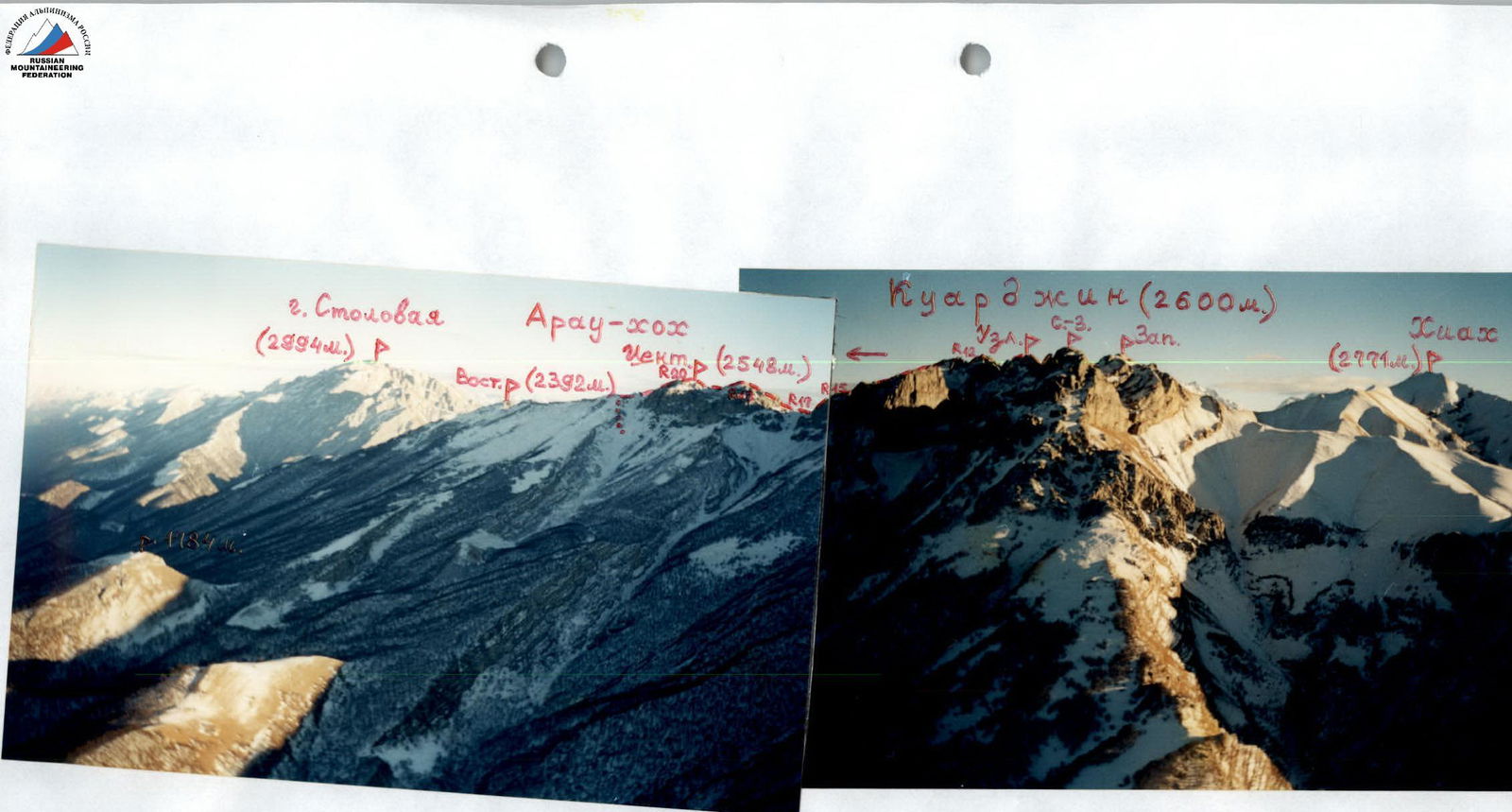
The Kuardjin-Araukhoh massif, belonging to the Rocky Range, is located on the territory of the Republic of North Ossetia - Alania, between the Genaldon and Terek rivers to the east. The massif is clearly visible from the city of Vladikavkaz and is located southwest of it at a distance of about 20 km. This section of the Rocky Range has always been frequently visited by climbers from North Ossetia in winter and during the off-season due to its close location, mainly for one-day training exits. Previously, this massif was only called Araukhoh. Only the following had specific names:
- the mark with a triangulation sign 2392 m - as Eastern Araukhoh;
- almost 2 km to the west of it - the summit Tsentr. Araukhoh (2548 m).
The remaining western part of the massif is a rocky ridge with a large number of gendarmes, sometimes reaching heights of up to 100 m. In terms of sports and technical terms, this section of the massif is the most interesting. Previously, this western part of the massif was called Araukhoh Zapadn. without specifying the location of the summit, since due to its complexity, this section of the ridge was rarely visited; only in 1987 did a group led by Yu. Levkovsky traverse from Arau East to the nodal gendarme (tower) in the western part of the massif (from which a long grassy ridge descends to the south to the summit Khiah (2771 m)).
The route was formalized in the mid-90s, and now it is a classified route of 2B category of difficulty as a traverse of Arau East - Kuardjin Uzlovoy (clause 2.8.1 of the new Classification).
The name Kuardjin appeared in the early 90s, when access to topographic maps of scale 1:50 000 became available. On these maps, the western part of the Araukhoh massif was designated as Kuardjin.
The ridge of the massif in the area of the Kuardjin summits has the form of a rocky ridge with walls up to 300 m on both sides. Yu. Levkovsky's group traversed from east to west only as far as the summit Kuardjin Uzlovoy.
Located to the west:
- the summit (tower) Kuardjin Tsentr. with a height of up to 100 m,
- the tower between Uzlovoy and Tsentr. Kuardjins.
These two towers were not included in their traverse. In technical terms, the ascent and traverse of these two towers is the most complex section of the ridge of the entire Araukhoh massif.
To the west of Tsentr. Kuardjin, beyond a несложным grassy ridge with rock outcrops, lies the Western tower of Kuardjin.
In its Northwest spur is located the Northwest tower. The heights of these towers are about 2550 m.
The traverse of these two towers to Kuardjin Tsentr (2600 m) does not present any technical difficulty and is almost the same ridge as between Araukhoh East and Araukhoh Tsentr.
In this regard, it was decided to traverse from west to east the most complex and interesting part of the massif in sports terms, namely:
- with an ascent to Kuardjin Tsentr from the south
- with a further traverse to Kuardjin Uzlovoy - a section of the ridge never before traversed by anyone
- with a subsequent traverse of the ridge to Araukhoh Tsentr - traversing the most complex section of Yu. Levkovsky's 2B category of difficulty route, but in the opposite direction.
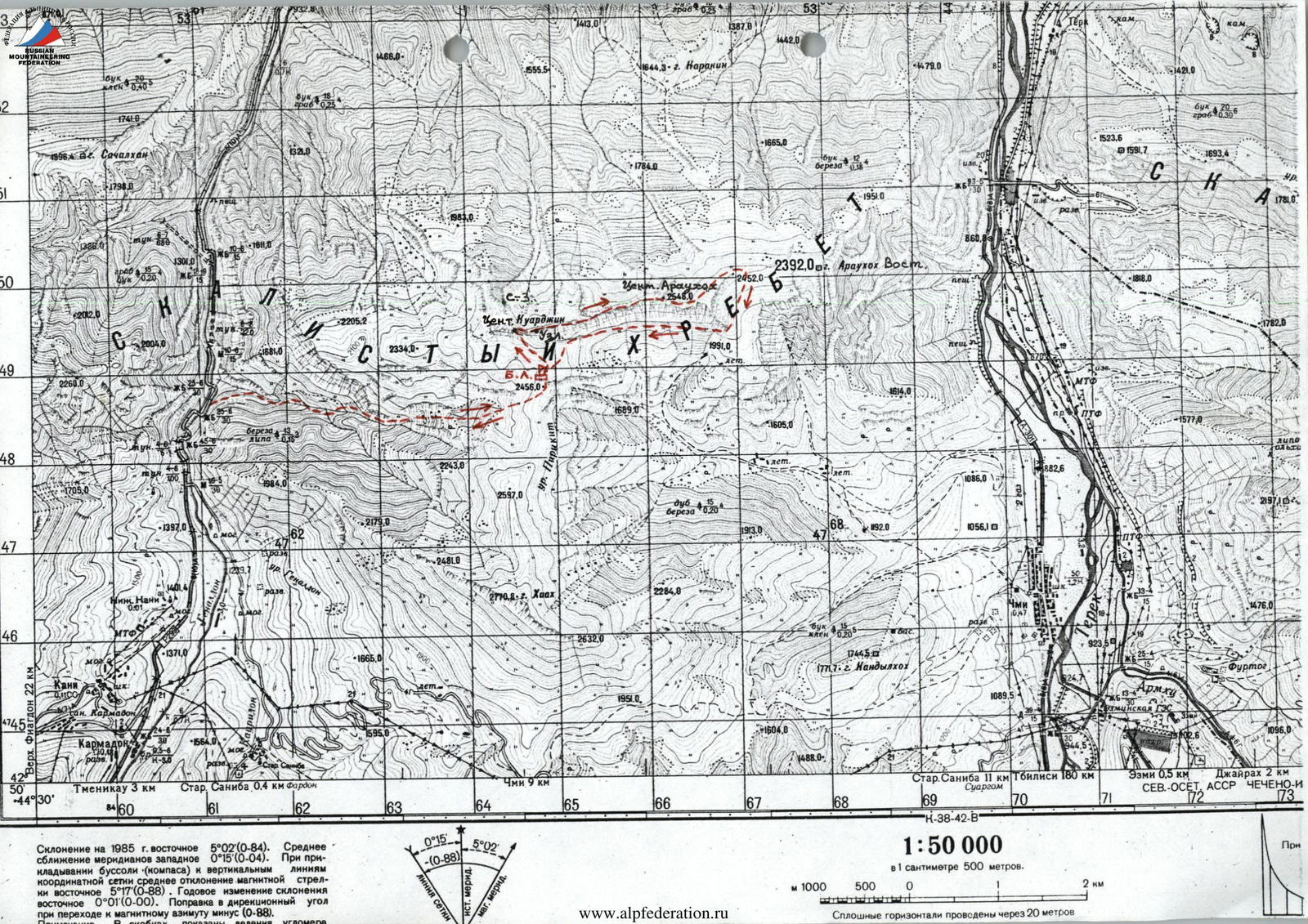
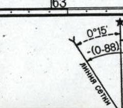
Declination for 1985 is eastern 6°00′08″. Average convergence of meridians is western 0°15′10″. When using a compass and vertical lines of the coordinate grid, the average deviation of the magnetic needle is eastern 6°17′10″. Annual change in declination is eastern 0°01′10″. Correction to the directional angle when switching to magnetic azimuth is minus 10°98.
1:50 000 — in 1 cm 500 m.
Photopanorama of the ascent area. View from the north, from a helicopter, January. The route of the first ascent is marked.
Description of Approaches to the Route
From the city of Vladikavkaz, take a regular bus to the Karmadon rock climbing area, which takes about half an hour. Then continue by bus up the gorge. After crossing the third bridge from the rock climbing area over the Genaldon River, exit under the beginning of the Genal tract, which is located east of the road.
The entrance to the tract is to the right of its bottom, along a trail located 150 m above the road. Follow this trail up the right (in the direction of travel) side of the gorge. The trail goes through the forest and is sometimes not clearly visible. After 1 hour, approach the fork of two gorges and turn into the left one.
After passing through the rocky gate formed by the surrounding walls, gradually start turning left. Here, the trail from the bottom of the gorge goes up to its left (in the direction of travel) side and follows along the forested slope, sometimes through scree.
After another hour from the fork of the gorges, the trail descends to the bottom of the gorge before the beginning of the canyon. Here is the only place in the entire gorge where, under favorable snow conditions, a stream is possible.
Then continue up again along the left slope along the trail, bypassing the canyon. Here, the trail sharply goes up and eventually exits the forest. After passing over vertically standing limestone layers, continue along the slope above the bottom of the gorge, crossing small grassy couloirs with ridges between them.
After about 1.5 hours from the stream, at the end of the canyon, descend to the bottom of the gorge and follow it up. At the fork of the gorges, turn left. Then climb up along the steep grassy slope between two sharp rocky ridges.
After reaching the slope's inflection, head towards the lowest saddle in the ridge between Kuardjin Uzlovoy to the left and the summit Khiah to the right. This saddle is the Oleniy pass. The height of the pass is 2450 m. Here is an overnight stay.
- Snow for water from November to May on slopes with northern exposure.
- Approaches from the highway take about 6 hours.
- Ascent is 1500 m.
From the overnight stay, the path of ascent to Kuardjin Tsentr. and further traverse to the east is clearly visible.
Description of the Route by Sections
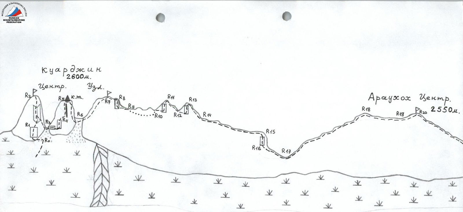
From the Oleniy pass, move north along the grassy ridge, which approaches under Kuardjin Uzlovoy. To the west of the latter are two towers. The westernmost one is Kuardjin Tsentr., from which the ascent begins. To do this, follow the grassy slopes to the southeastern side of the summit Kuardjin Tsentr. From the pass, it takes 20 minutes.
R0–R1: Approaching the southeastern side of the tower, examine the easiest path of ascent to the summit. Turning left, exit onto a small saddle under the key section of the route. The path along the rocks is 2-3 category of difficulty, 30 m. From the saddle, directly up along the rocks of 4 category of difficulty, 10 m. In the upper part of the wall, there is a section of 5 category of difficulty, 2 m, followed by an exit to scree shelves.
R1–R2: Move along the shelves to the right and up 10 m under the right side of a vaguely expressed internal corner and climb up along it through rocks of 4 category of difficulty to a scree couloir. Along the couloir of 1-2 category of difficulty, ascend to the summit Kuardjin Tsentr. The entire section is 60 m.
R2–R3: From the summit, rappel back to the beginning of the internal corner. Then another rappel directly to the east, slightly south of the saddle between the next tower and Kuardjin Tsentr. The entire section is 80 m.
R3–R4: To ascend to the tower between Kuardjin Tsentr. and Kuardjin Uzlovoy, follow the shelves to approach under the southwestern side of this tower - under the wall with a chimney. Along the left side of the chimney, and then along the right, exit through 10 m of 3-4 category of difficulty to the scree slopes above the wall. The entire section is 60 m.
R4–R5: Along the scree slopes, exit to the top of the ridge and climb to the summit of the tower. Here is a control cairn. The entire section is 1-2 category of difficulty, 60 m.
R5–R6: Slightly returning south along the ridge, rappel down to the east along steep walls with a small number of cracks for hooks. On the second rappel, descend to the south along a cleft in front of a fragment. The entire section is 60 m. From the start of the route, it takes about 3 hours.
R6–R7: Ascend to the summit Kuardjin Uzlovoy from the saddle along the western ridge. The ridge is rocky-grassy, 80 m, 1-2 category of difficulty. Further traverse to Araukhoh Tsentr. follows Yu. Levkovsky's 1987 route of 2B category of difficulty, but in the opposite direction.
R7–R8: From the summit, follow the eastern ridge of 2 category of difficulty, 40 m to the shoulder of the ridge.
R8–R9: Approaching the wall, rappel 20 m to the shoulder of the ridge.
R9–R10: The next ascent of the ridge is bypassed along the northern slopes: to do this, from the end of the rappel, move along a small ridge to the north. Along a rocky-grassy couloir - 10 m descend under the base of the ridge's ascent. Then, traversing the northern slope, exit to the saddle behind the rocky ascent. The entire section is 80 m, 2-3 category of difficulty.
R10–R11: Ascend to the first triangular gendarme directly along the ridge 60 m, along rocks of 3 category of difficulty.
R11–R12: Descent from the gendarme to the saddle - 60 m, 2-3 category of difficulty, along the ridge, bypassing complex sections along shelves. At the end of the section, move slightly south and bypass the gendarme along a scree couloir with an exit to the saddle of the ridge.
R12–R13: Ascend to the second triangular gendarme directly along the ridge of 4 category of difficulty, 50 m. Insurance is with hooks and rock features.
R13–R14: Descent from the gendarme along a rocky-grassy ridge: first 3 category of difficulty, then 1-2 category of difficulty. The details of the section are 100 m.
R14–R15: Further along a long grassy ridge with simple rock outcrops, approach to the shoulder of the ridge before the saddle between the summits Kuardjin Uzlovoy and Araukhoh Tsentr. The entire section is about 400 m, 1-2 category of difficulty.
R15–R16: From the shoulder, along the shelves, approach to the wall of 4 category of difficulty, 5 m, and rappel down it. The entire section is 20 m.
R16–R17: From under the base of the wall, move right along a shelf to the ridge and along it exit to a grassy saddle. The entire section is 100 m, 1-2 category of difficulty.
R17–R18: Further, ascend along the ridge to the east to the summit Araukhoh Tsentr. The ridge is rocky-grassy, 1-2 category of difficulty, all complex sections are bypassed along shelves, first from the south of the ridge, then from the north. The entire section is about 400 m.
R18–R19: After descending from the summit to the saddle, continue traversing the northern slopes of the gendarmes ahead. Exit to the ridge behind them, before the summit ascent of Araukhoh Tsentr. The entire section is 300 m, 1-2 category of difficulty.
R19–R20: The ascent to the summit Araukhoh Tsentr follows the northwestern slope - 1-2 category of difficulty, along shelves and through small walls of 3 category of difficulty. The entire section is 150 m.
Overnight stays are possible throughout the route. From the start of the route, it takes about 8 hours.
Descent from the summit Araukhoh Tsentr goes east to the lowering of the ridge before the ascent to Araukhoh East. The ridge is rocky-grassy, 1-2 category of difficulty.
Further descent from the route is possible:
- further along the northeastern slopes of the massif
- with a descent to the settlement Balta on the Military Georgian Road - about 4 hours.
Another option (if the bivouac was left on the Oleniy pass): from the saddle, descend south, below the southern walls of the massif, and under them return west to the Oleniy pass with a gain of about 100 m. To the pass, it takes about 2 hours. Then descend west - into the Genal tract, along the ascent path with an exit to the highway in the Genaldon gorge. Another 3 hours.
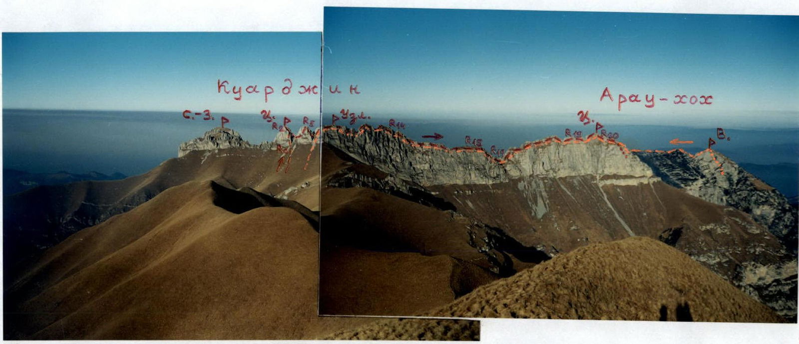
View of the Kuardjin-Araukhoh massif from the south, from the summit Khiah (2771 m). October.
The route of the first ascent is marked in red. Yu. Levkovsky's route of 2B category of difficulty is marked in orange.
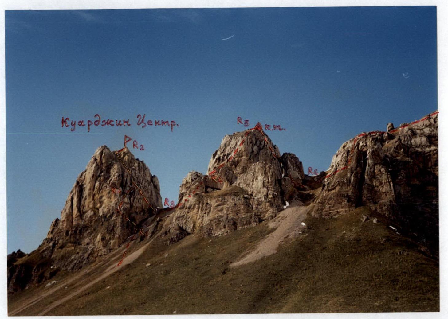
The path of ascent to Kuardjin Tsentr. and the beginning of the traverse. View from the southeast. May.
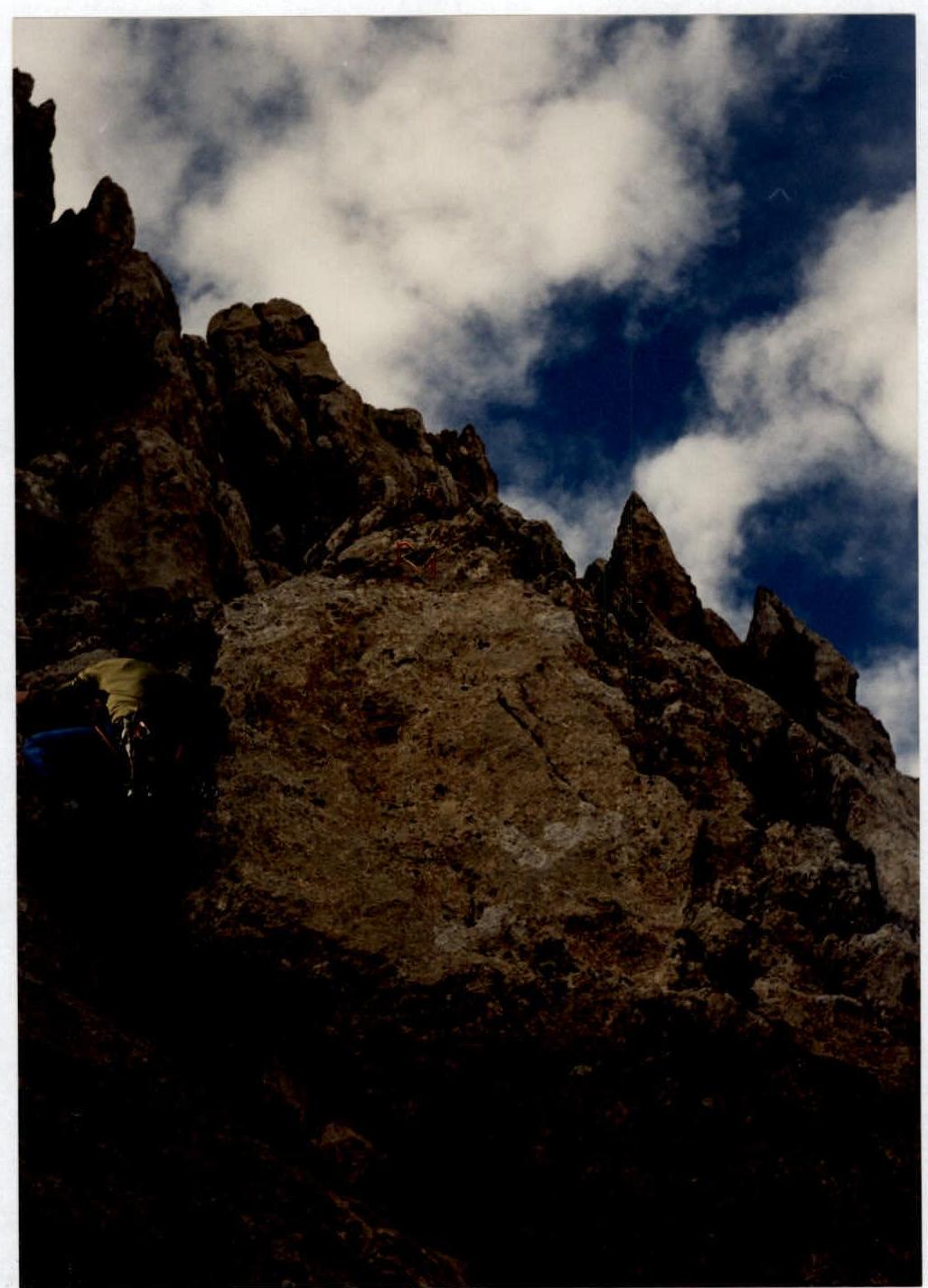
Passage of the section R0–R1. Upper part of the wall.
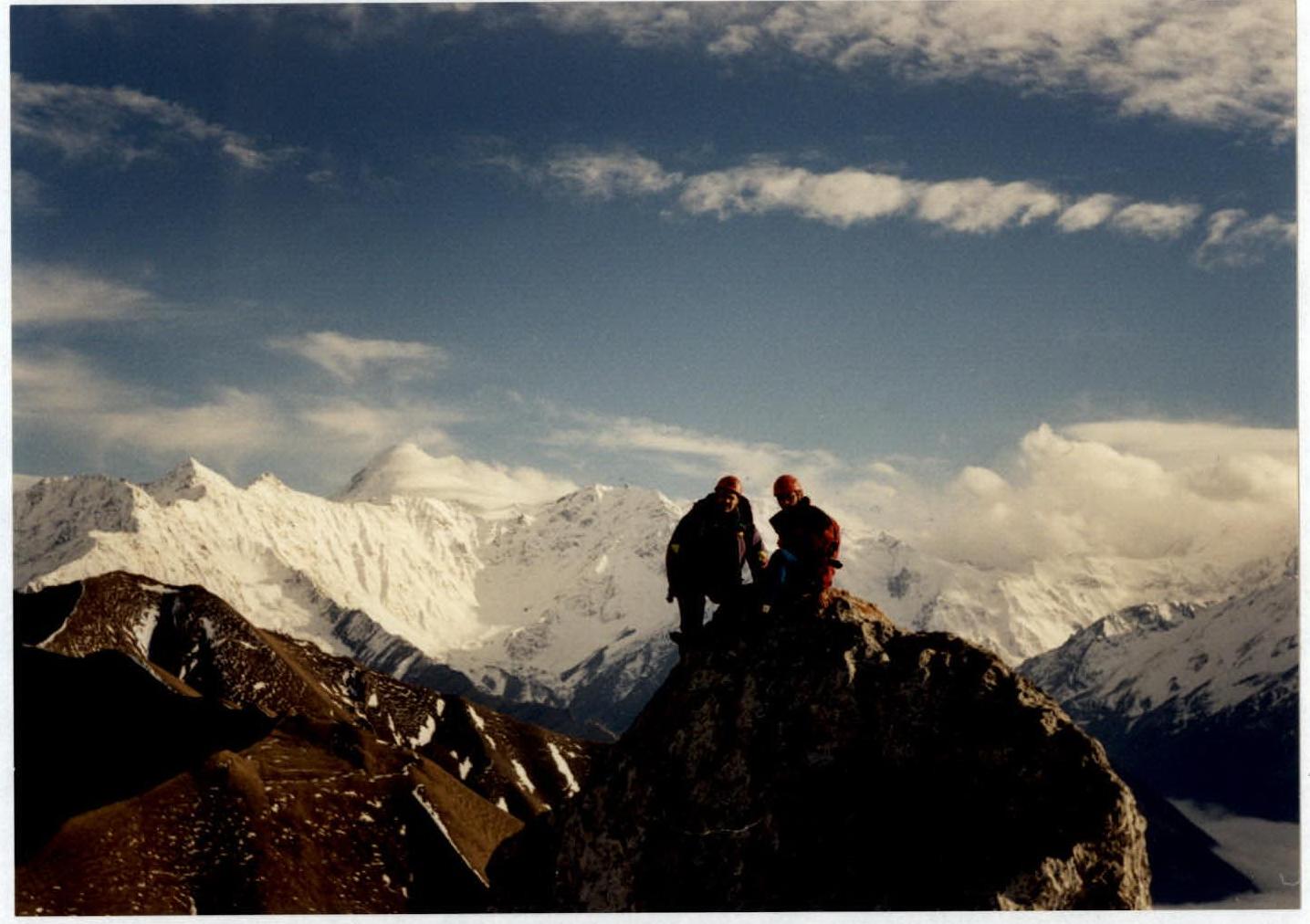
On the summit Kuardjin Tsentr. In the background - Mount Kazbek.