Ascent Log
I. Ascent category: rock climbing 2. Ascent area: Caucasus, 28, Arau-khokh massif 3. Peak, route: p. Arau-khokh (2392 m) — p. Kuardjin Uzl. (2611 m) — traverse from east to west. 4. Estimated cat. difficulty 2B: p/p 5. Route characteristics:
Height difference – 220 m, route length – 4000 m, section lengths:
- 3 – 100 m
- 4 – 70 m, average steepness of the main part of the route – 40°
- Pitons driven:
- rock – 3 pcs., chocks – 1 pc., ice screws – none
- Number of climbing hours/days – 15/2
- Number of overnight stays: 1 – on the route
- Leader: Levkovsky Yu. V. – 1st sports category Afanasyev I. O. – 3rd sports category, Zevakhin G. Yu. – 3rd sports category.
- Coach: Proskuryakov Ruslan Pavlovich – Master of Sports
- Route entry – November 13, 1987 Return – November 14, 1987
- Organization: KAM FA of North Ossetia.
Route Description
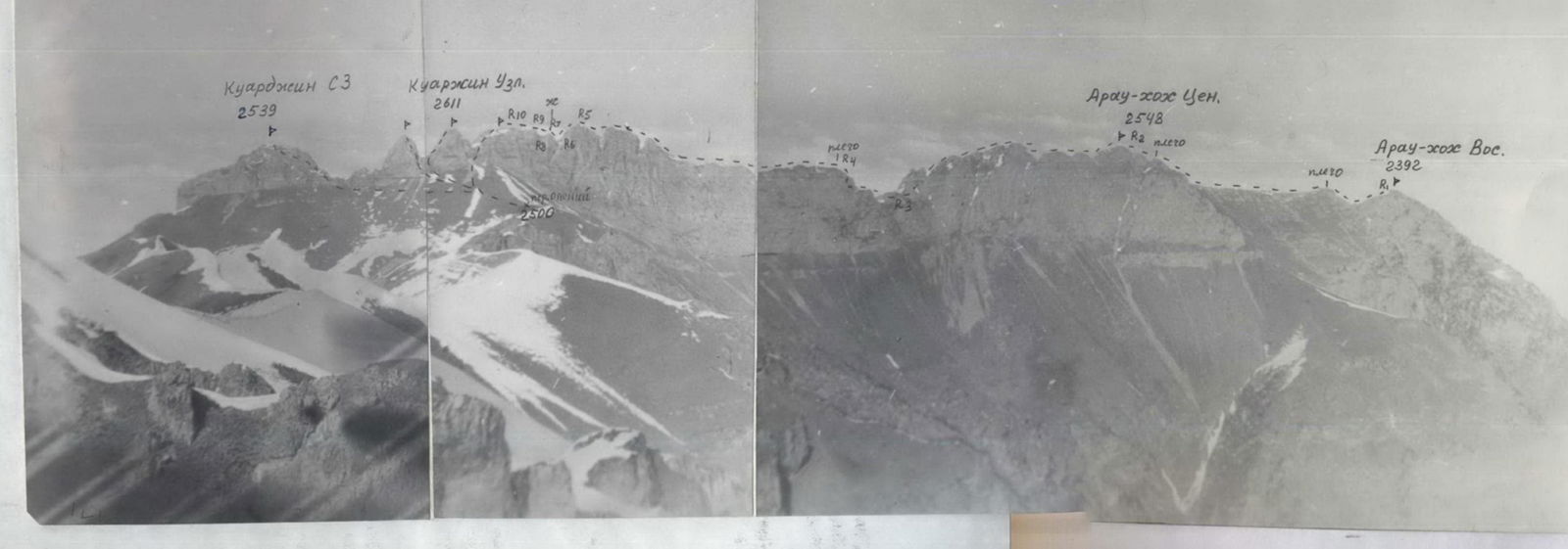
From the saddle, move left-up along grassy slopes, partly in the forest, and exit onto the shoulder of the Eastern ridge of p. Arau-khokh Vos. – 3 hours. Turn right, ascend along the northern side of the eastern ridge under the rocky tower of the summit, composed of destroyed limestones. Ascent to p. Arau-khokh Vos. (2392 m) via rocks 2: 50°, 20 m. Section R0–R1. From the shoulder on the ridge – 1.5–2 hours.
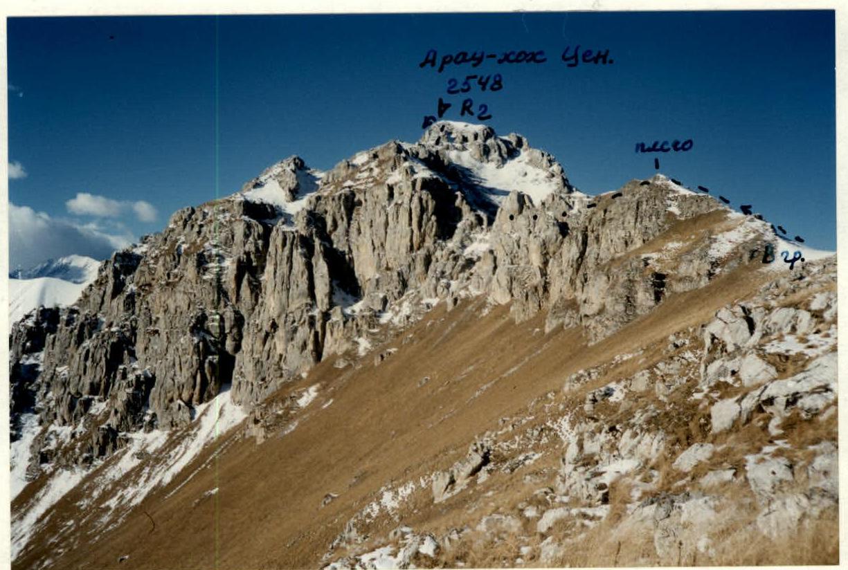
Descend from the summit via the ascent path, then turn left, traverse along the grassy slope to reach the saddle. A bivouac is possible. From the saddle, ascend 80 m to the shoulder of the eastern ridge of p. Arau-khokh Cent. and along a gentle long grassy ridge with rock outcrops, approach the second shoulder before p. Arau-khokh Cent. in 1 hour. Ascend directly up to the shoulder, bypass it by traversing right-down to the saddle, from which ascend along a steep grassy slope to p. Arau-khokh Cent. (2548 m). The summit is grassy with rock outcrops.
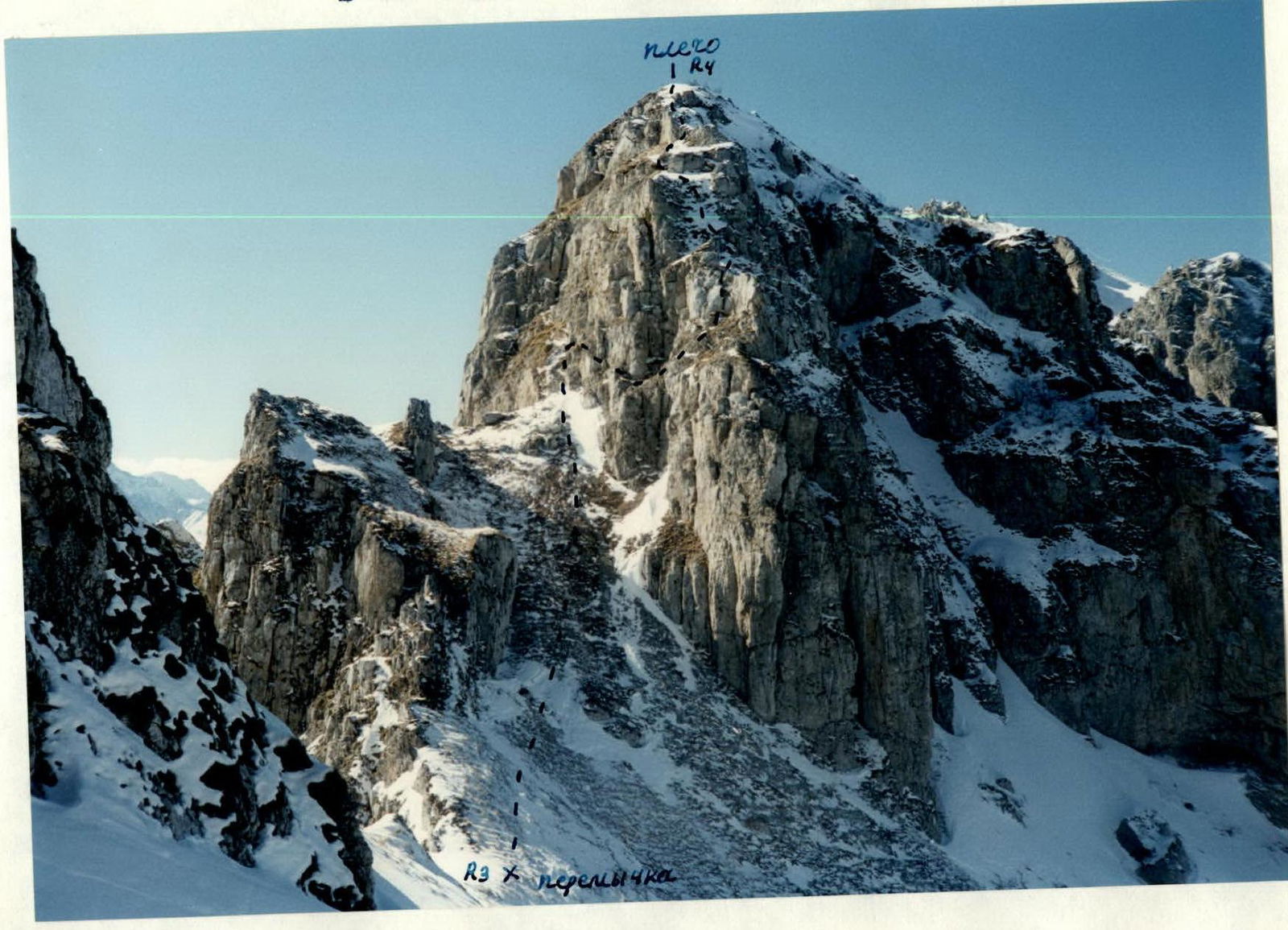
Descend from the summit west along a simple ridge 60–80 m to rocky drops. Along steep destroyed rocks 3: 50–60°, 40 m – descend to the ridge. Move along the ridge, bypassing rocks from the northern side along steep grassy slopes, and ascend to a gentle shoulder, descend from which to the ridge, then from the ridge traverse left-down, bypassing rocks along steep grassy slopes, with belay, to the saddle under the eastern ridge of p. Kuardjin Uzl. From p. Arau-khokh Vos. – 3 hours. On the saddle – bivouac. Section R2–R3. The route to p. Kuardjin Uzl. along the eastern ridge is the key section of the route.
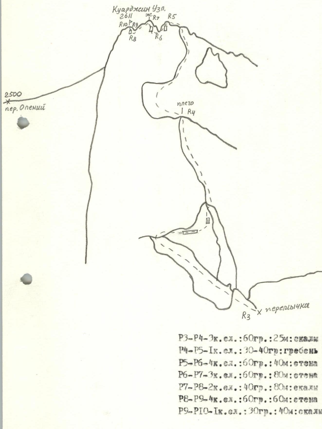
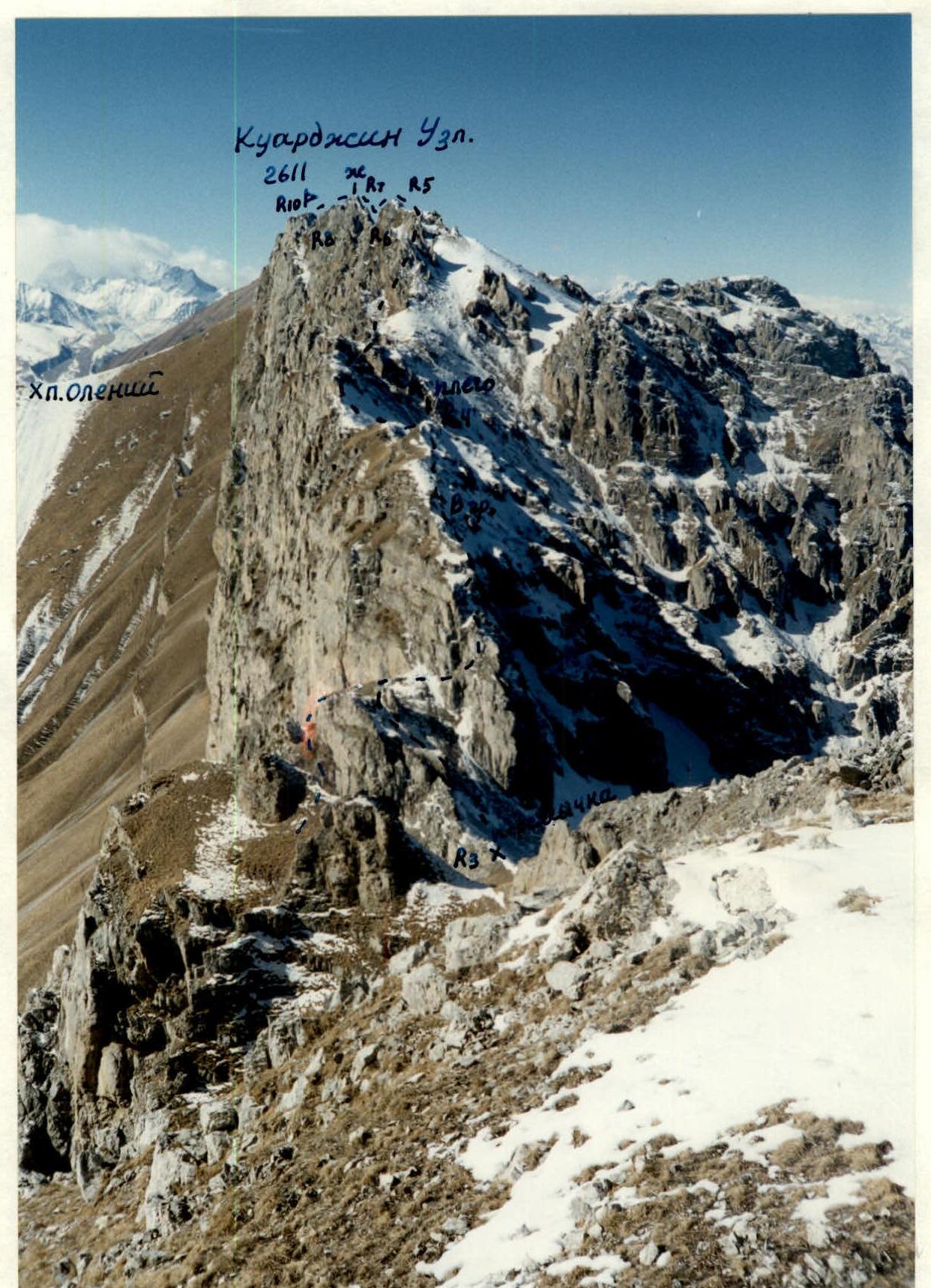
From the saddle – approach the beginning of the eastern ridge from the left side. Along a steep grassy-rocky ledge 40 m, then along the wall 4: 60–70°, 7–8 m – ascend to the ridge, along which – exit to the shoulder. Further – move along a simple gentle long ridge to the depression – 1 hour. Descend into the depression to the saddle 40 m: 60° via rappel. Along a gentle rocky saddle 10 m – approach the wall. Ascend left-up along the wall 3+: 60°, 80 m: R6–R7, piton belay, to a pinnacle. Move along a simple ridge under the wall of the tower of the summit. Along the wall 4: 60°, 60 m: R8–R9 – ascend to p. Kuardjin Uzl. (2611 m). From the saddle – 5–6 hours.
The summit is grassy-rocky, representing the end of the eastern ridge. Further to the west are separate standing towers of equal height, 80 m high. Climbers visited their summits, no records or cairn traces were found. Ascent to the towers – 4B cat. difficulty. It is more logical to consider the first summit from the east as the endpoint of the route, as it is the one approached by the ridge coming from p. Khiah. This is also evident from the topographic map. Descend from the summit southwest along simple ledges 80 m to the ridge and further to Oleniy pass. A good bivouac.
Descent
Descend from Oleniy pass west along the bottom of the gorge, after 30–40 min. turn right and continue descending by traversing along steep grassy slopes, rising higher above the gorge bottom. After 1–1.5 hours, near a large cave (kosha), start a gradual descent by traversing into the gorge and after another 1 hour descend to the gorge bottom along a faint path, along which continue moving until its end, before which turn left along the path and descend along it to the bypass road of the 2nd tunnel. After 100 m, cross the bridge and exit to the main road at the beginning of the tunnel.
Rocky ridge (massif of p.p. Arau-khokh) M: 1:50 000
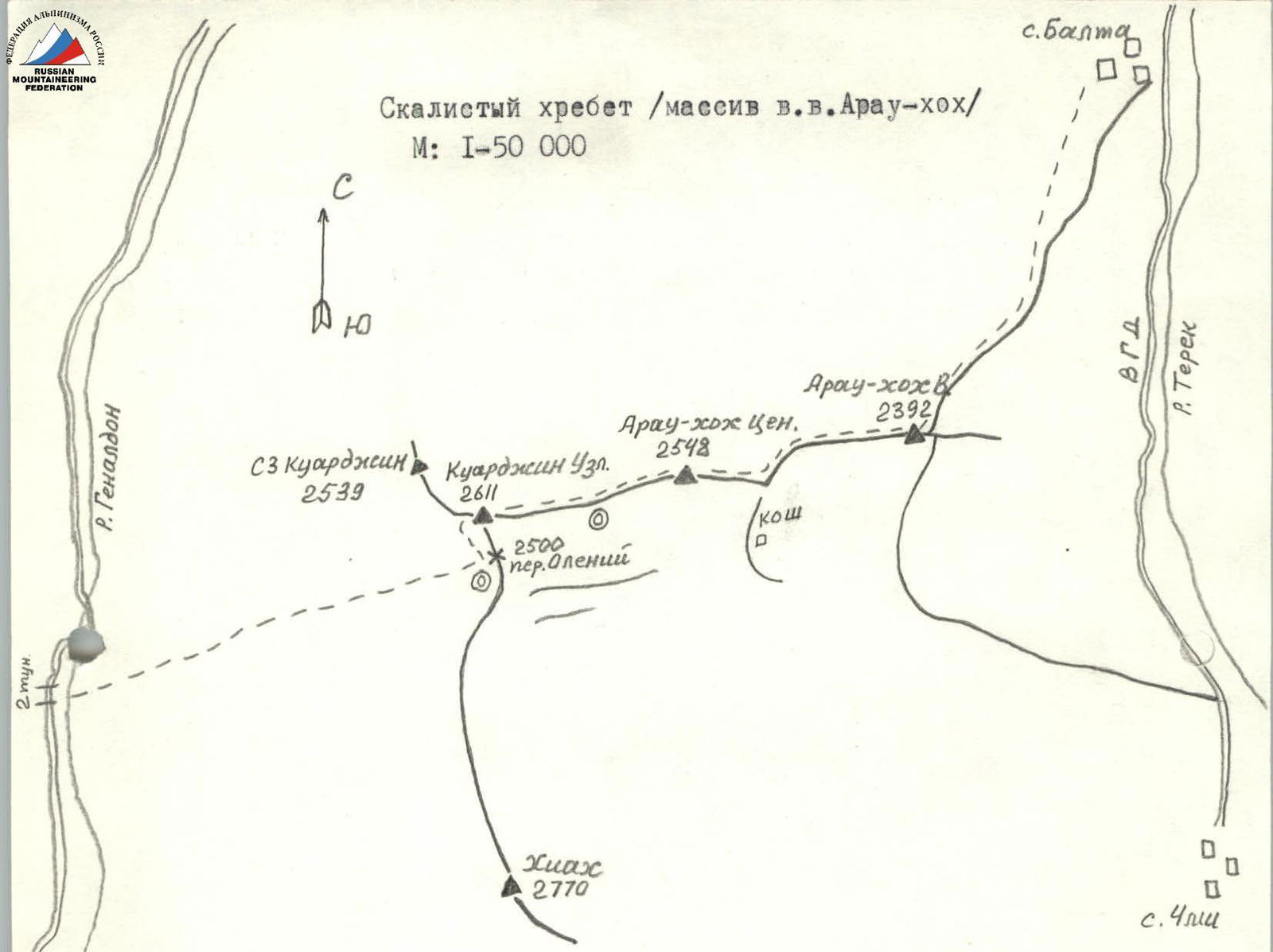
p.p. Arau-khokh Vos. — Arau-khokh Cent. — Kuardjin Uzl.
R0–R1: 30–40°, 2, 20 m, rocks
R1–R2: 30–40°, 1, ridge
R2–R3: 40–50°, 2, 40 m, wall, ridge
R3–R4: 60°, 3, 25 m, rocks
R4–R5: 30–40°, 1, ridge
R5–R6: 60°, 4, 40 m, wall
R6–R7: 60°, 3, 80 m, wall
R7–R8: 40°, 2, 80 m, rocks
R8–R9: 60°, 4, 60 m, wall
R9–R10: 30°, 1, 40 m, rocks
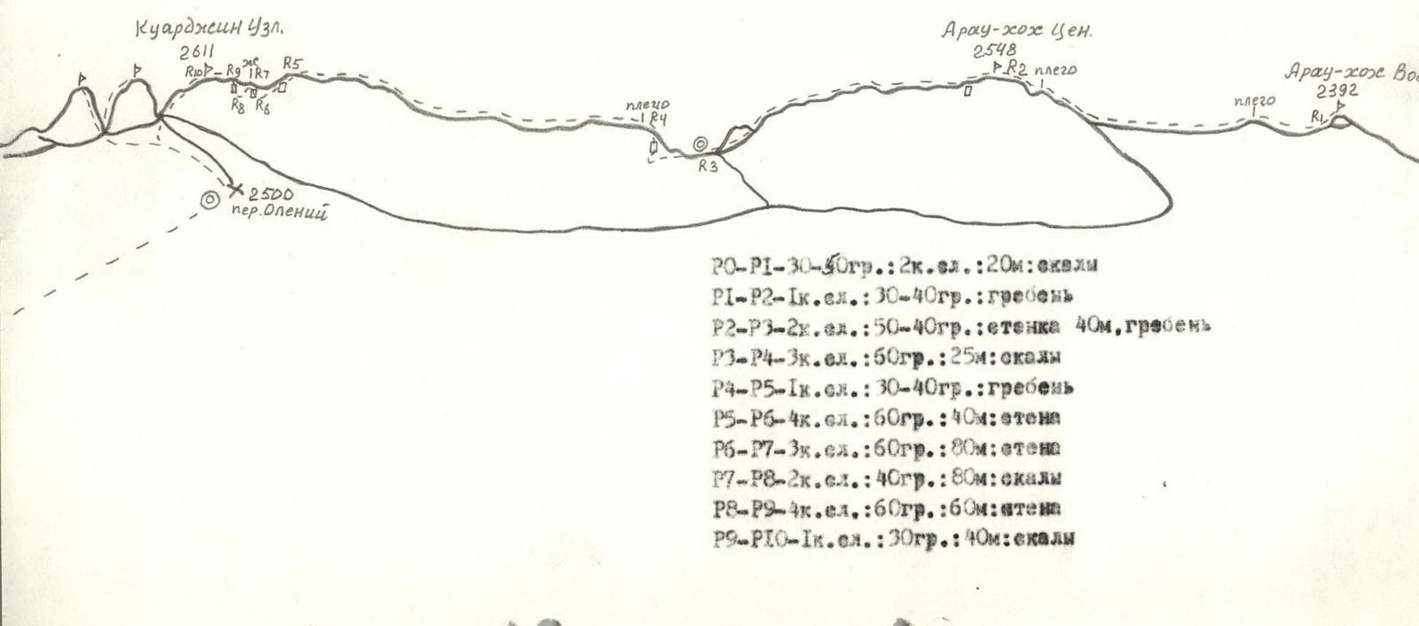
Key Section
R3–R4: 60°, 3, 25 m, rocks
R4–R5: 30–40°, 1, ridge
R5–R6: 60°, 4, 40 m, wall
R6–R7: 60°, 3, 80 m, wall
R7–R8: 40°, 2, 80 m, rocks
R8–R9: 60°, 4, 60 m, wall
R9–R10: 30°, 1, 40 m, rocks
View from the North (Gizeldon river gorge)

View from the South (from p. Khiah)
View from the West
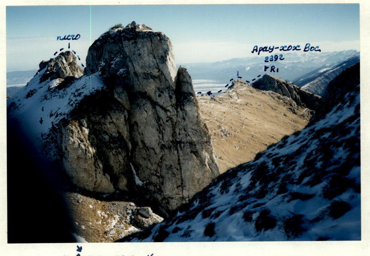
View from the East
 February 1997
View from the East
View from the East
 February 1997