
Ukrainian Council
With “Burevestnik” Sports Society
Dedicated to our teacher and friend Vitaly Vasilyevich OVCHAROV in honor of the 25th anniversary of his mountaineering career.
Chanchakhi–Khokh
via the central bastion of the northern wall (first ascent) 4461 m
Kiev, 1968
Sporting Characteristics of Chanchakhi–Khokh Peak
Chanchakhi–Khokh peak is one of the most inaccessible peaks in the Tsey region. The easiest route to it is a category 4B route via the snowy couloir from the south. In addition, there are three category 5B routes via the Northern wall.
The Northern wall majestically towers over the plateau of the Northern circus of the Tsey glacier.
The conquest of the Northern wall has its history. It was first ascended in 1954 in its left part (through the so-called "snow spot") by a team from the Central Council of the "Spartak" Sports Society led by Honored Master of Sports of the USSR V. M. Abalakov.
It should be noted that this was one of the first Soviet wall ascents. For passing this route, the Spartakovites were awarded gold medals as champions of the USSR in the class of technically complex ascents.
In 1960, a duo of climbers (Nosov and Tsirkunov) laid a new route via the Northern wall of Chanchakhi–Khokh, also through the "snow spot." Their route represents an almost vertical line and differs significantly from the Spartakovites' path up to the "spot," and after the "spot," it passes only slightly to the right of their path.
In 1966, a group of Kharkov climbers from the "Avangard" Sports Society led by Master of Sports of the USSR V. S. Neborak laid a route in the right part of the Northern wall via the right "bastion." All paths traversed via the Northern wall are routes of the highest category of difficulty and are of great sporting interest. It should be noted that the conquered routes are somewhat deteriorated. The rest of the area represents monolithic granite.
The second section (from the ledge to the first snow-ice ledge) is a steep rocky face. Characteristics of the section:
- In the lower part, there are several overhanging sections.
- The exit from the ice ledge is particularly challenging.
- In the upper part, the rocks are slightly more gentle but are covered with rimaye ice.
- The length of the section is about 150 m.
- The average steepness is around 75°.
- The rocks are strong, monolithic granite.
The third section (from the first snow-ice ledge to the second snow-ice ledge) is a completely sheer wall with large cornices. This is one of the most challenging sections on the route. Characteristics of the section:
- The steepness of the sections is about 90°.
- The length is around 180 m.
- The rocks are strong, smooth, like "ram's foreheads."
- Near the cornices, they are slightly deteriorated.
The fourth section (from the second snow-ice ledge to the exit onto the ridge) consists of rocks, in many places covered with rimaye ice. The section is very complex at the beginning, where the rimaye ice covers sheer rocks. Then the rocks become slightly more gentle. The length of the entire section is around 300 m. The average steepness is 70°. In the lower part, the rocks are monolithic and strong. After becoming more gentle, the rocks are very deteriorated and require great caution when overcoming.
The section from the point where the team exits onto the ridge to the summit is a rocky ridge with a series of complex gendarmes. The length of the ridge from the exit point to the summit is over 350 m with an average steepness of 45–50°. They are equally difficult. The Spartakovites' route is considered the "easiest," and the "Avangard" route is the most difficult.
Out of the logical paths for ascending via the Northern wall of Chanchakhi–Khokh, only one route had not been laid. This is a complex, beautiful, and extremely interesting route via the central "bastion."
The central "bastion" is referred to as a slightly protruding area of the wall into the Northern circus of the glacier. Ascending via the central "bastion" is of great sporting interest as a wall route, the passage of which requires climbers to master the entire arsenal of high-level rock and ice climbing techniques.
Over the past five years, this route has attracted the attention of many climbers. Several teams from various sports societies have entered it for participation in the USSR Championship in mountaineering. However, only a few teams have attempted to conquer the central "bastion" of the Northern wall of Chanchakhi–Khokh. These include:
- The team from the Central Council of the "Trud" Sports Society in 1965,
- The Central Council of the "Daugava" Sports Society in 1966,
- The Central Council of the "Burevestnik" Sports Society in 1967.
But due to a number of technical and tactical reasons, the climbers were forced to retreat.
The route via the central "bastion" of the Northern wall can be divided into four main sections. The first section is from the bergschrund to the ice ledge, representing a sheer wall approximately 180 m long. The overall steepness of the first section is over 80°. In many places, there are overhanging sections. The rocks are smooth, with very few holds. Before exiting onto the ledge, the rocks.
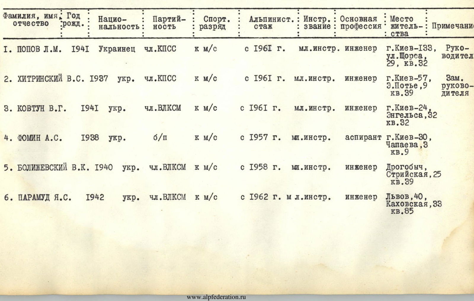
Composition of the Assault Team
| Surname, First Name, Patronymic | Year of Birth | Nationality | Party Membership | Sports Rank | Mountaineering Experience | Instructor Rank | Main Profession | Place of Residence | Note |
|---|---|---|---|---|---|---|---|---|---|
| POPOV L. M. | 1941 | Ukrainian | CPSU member | CMS | since 1961 | Junior Instructor | Engineer | Kiev–133, Shchorsa St., 29, apt. 32 | Team Leader |
| KHITRINSKY V. S. | 1937 | Ukrainian | CPSU member | CMS | since 1961 | Junior Instructor | Engineer | Kiev–57, E. Potye St., 9, apt. 39 | Deputy Team Leader |
| KOVTUN V. G. | 1941 | Ukrainian | Komsomol member | CMS | since 1961 | Junior Instructor | Engineer | Kiev–24, Engels St., 32, apt. 32 | |
| FOMIN A. S. | 1938 | Ukrainian | Non-party | CMS | since 1957 | Junior Instructor | Postgraduate student | Kiev–30, Chapayev St., 3, apt. 9 | |
| BOLIZHEVSKY V. K. | 1940 | Ukrainian | Komsomol member | CMS | since 1958 | Junior Instructor | Engineer | Drohobych, Stryiska St., 25, apt. 39 | |
| PARAMUD Ya. S. | 1942 | Ukrainian | Komsomol member | CMS | since 1962 | Junior Instructor | Engineer | Lviv, 40, Kakhovskaya St., 33, apt. 85 |
According to the Team's Instructions
The total height difference from the bergschrund to the ridge is 750 m with an average steepness of 72°. The height difference from the exit point onto the ridge to the summit is 250 m with an average steepness of 45°.
The team from the Ukrainian Council of the "Burevestnik" Sports Society has been entering this route for participation in the USSR Championship in mountaineering in the class of technically complex ascents over the past three seasons (1966–1968).
- In the 1966 season, the ascent was not successful due to several key team members being unable to arrive at the mountains for various reasons.
- In the 1967 season, the team competed under the flag of the Ukrainian Republican Union of Sports Societies and Organizations. They attempted to conquer the central "bastion" but processed only the first section before being forced to retreat due to extremely adverse weather conditions.
- Only in the 1968 season did the team from the Ukrainian "Burevestnik," competing under the flag of the Central Council of the "Burevestnik" Sports Society, consisting of 6 people, successfully complete the first ascent of the central "bastion" of the Northern wall of Chanchakhi–Khokh peak. The ascent took place from August 8 to August 16 (including one day for processing) in 1968. The days of approach and descent from the alpine camp to the base camp are not included in this timeframe.
Tactical Plan for the Ascent
The tactical plan for the ascent was developed even before the team arrived at the mountains. The route was divided into five main sections:
- First "bastion" (from the bergschrund to the ice ledge) — a wall approximately 180 m long with an average steepness of 80°.
- Second "bastion" (from the ledge to the first snow-ice ledge) — a wall approximately 150 m long with an average steepness of 70°.
- Third "bastion" (from the first snow-ice ledge to the second snow-ice ledge) — a sheer wall with two cornices. One of the most challenging sections on the route. Its length is 180 m, with an average steepness of around 90°.
- Fourth "bastion" (from the second snow-ice ledge to the exit onto the western ridge of the peak). In many places, the rocks are covered with ice. The beginning of the fourth bastion is particularly complex. The length of the section is around 300 m with an average steepness of 70°.
- Western ridge of the peak — combined, approximately category 4B. Its length is around 350 m with an average steepness of 45°.
The movement schedule and daily load were established based on the technical difficulty of the route, considering possible bivouac locations, the good organization of which contributes to the recovery of the climbers' working capacity.
Throughout the entire route, there is no possibility of organizing a lying-down bivouac for a group of 6 people. Relatively convenient places for organizing bivouacs are:
- The ice ledge under the II bastion;
- The first snow-ice ledge under the III bastion;
- The second snow-ice ledge under the IV bastion;
- In the upper part of the IV bastion;
- On the summit of Chanchakhi–Khokh.
There are no other places for organizing even a sitting bivouac. Only hanging overnight stays are possible. The technical complexity of the route, according to the team's assessment, required more than one day of work for the first, third, and fourth sections. Considering that organizing a bivouac in such conditions takes 2–3 hours, and that the weather in the circus tends to deteriorate in the second half of the day, it means that from one possible bivouac location to the next requires 2 days of intense work.
To avoid hanging overnight stays, it was decided to process the first, third, and fourth sections over two days, i.e.:
- to spend two nights on the first and second snow-ice ledges;
- to carry out preliminary processing of the first bastion.
Depending on the amount of equipment required for passing a given section, it was planned to send 2–3 people for processing.
To avoid carrying extra lengths of the main rope (40 m), it was decided to use:
- 4 lengths of 60 m.
To facilitate the pulling up of rucksacks, it was planned to take:
- 2 blocks;
- an auxiliary rope 60 m long.
Based on the above, the tactical plan for the ascent was structured as follows (organization of the base camp is part of the ascent preparation):
- Day I. Processing of the I bastion; descent to the base camp; bivouac in the base camp on the plateau under the wall.
- Day II. Passage of the first bastion; overnight stay on the ice ledge (bivouac 1).
- Day III. Passage of the II bastion; overnight stay on the first snow-ice ledge (bivouac 2).
- Day IV. Processing of the III bastion; overnight stay on the first snow-ice ledge (bivouac 3).
- Day V. Passage of the III bastion; overnight stay on the second snow-ice ledge (bivouac 4).
- Day VI. Processing of the IV bastion; overnight stay on the second snow-ice ledge (bivouac 5).
- Day VII. Work on the IV bastion; overnight stay on the wall (bivouac 6).
- Day VIII. Passage of the IV bastion and the western ridge of the peak; overnight stay on the summit (bivouac 7).
- Day IX. Descent from the summit via the category 4B route to the Chanchakhi–Khokh glacier, passage of the Tsey-Tbilisi pass, and return to the camp.
- Day X. Reserve for bad weather.
Thus, 9 working days were required to complete the route. It was decided to take provisions for 10 days (with one day as reserve).
Since the route passes via the Northern wall, work on the rocky sections was planned to start no earlier than 6:00 AM. This distribution of departure and movement times on the route proved to be fully justified. The team from the Ukrainian Council of the "Burevestnik" Sports Society began their ascent of Chanchakhi–Khokh peak via the central "bastion" of the Northern wall on August 8, 1968.
Route Description
Day I — August 8, 1968 — processing day for the beginning of the route. The starting point for the assault is the base camp under the Northern wall of Chanchakhi–Khokh on the plateau of the Northern circus of the Tsey glacier — 3350 m.
At 6:30 AM, the duo Fomin–Paramud left the base camp to process the first "bastion," taking with them:
- 3 main ropes of 60 m each,
- ladders,
- a platform,
- hooks: rock, ice, and expansion bolts, etc.
The rest of the team remained in the base camp, observing the duo and preparing for their turn to exit onto the route.
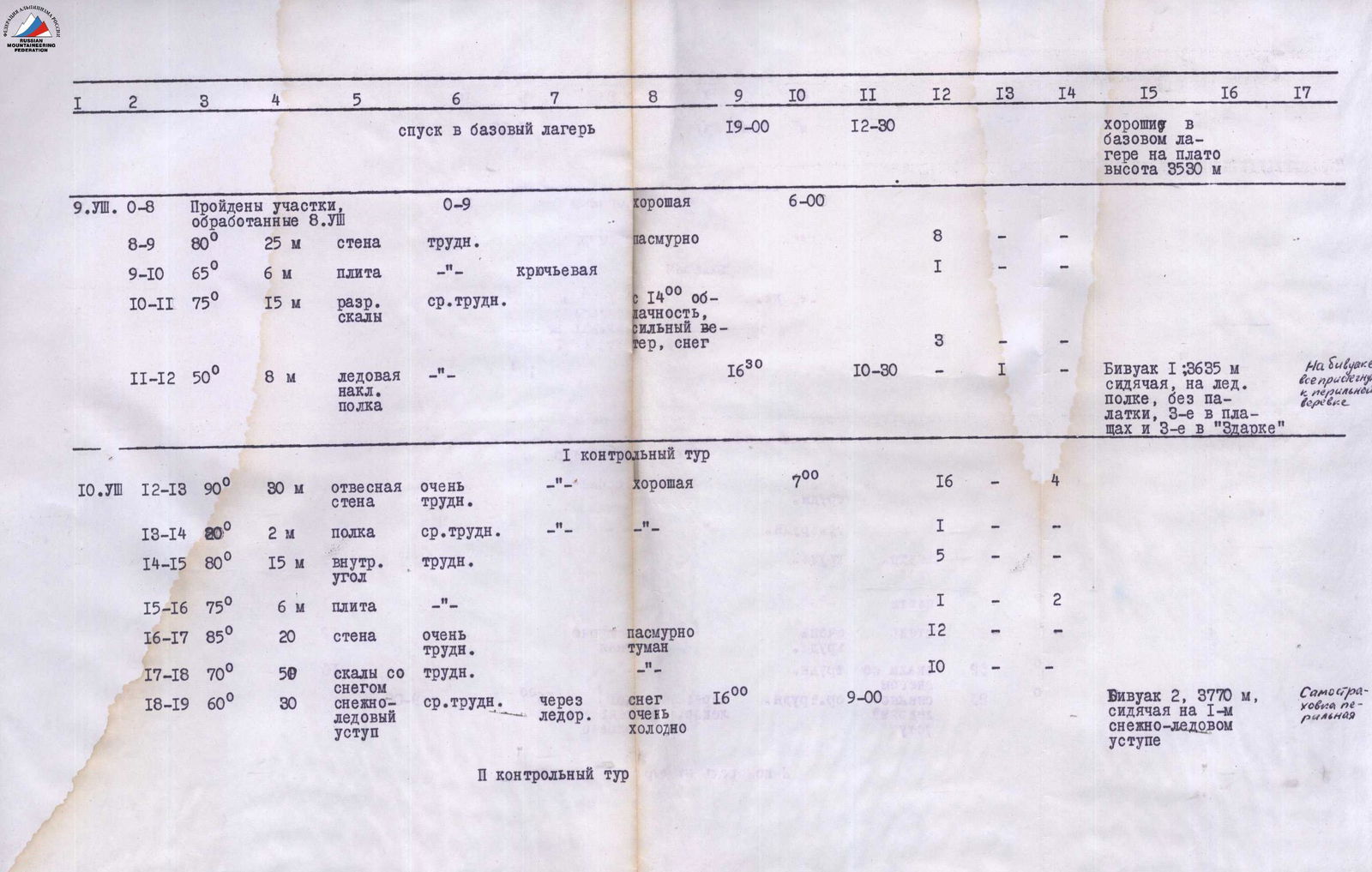
From the plateau, they ascended to the bergschrund, overcame it through a snow plug, traversed an icy slope (40 m) on crampons with step-cutting — exit to the start of the rocks (4 ice screws) — section R0–R1. Then another 20 m via несложным скалам до начала крутой части «бастиона» — участок R1–R2.
R2–R3. Крутая, заглаженная стена 85° — 30 m. Very difficult climbing using ladders and a platform (18 rock and 2 expansion bolts).
R3–R4. Плита с малым количеством зацепок 70° — 8 m. Overcome by natural climbing (2 rock hooks).
R4–R5. Стена 80° — 10 m. Rocks are smooth, strong, with a small number of holds (3 rock hooks). Exit onto a ledge.
R5–R6. Ледge шириной 1,5 m с наклоном 30°. Rimaye ice (1 hook).
R6–R7. Отвесная стена 90° — 20 m. Very difficult climbing. The number of holds and cracks is insignificant. Overcome with the help of ladders and platforms (14 rock and 2 expansion bolts).
R7–R8. Внутренний угол 80° — 12 m. Very difficult. In the upper part, ladders are used (4 hooks).
The rope is fixed, and the duo descends to the base camp. At 19:00, the duo is back on the plateau. The section R0–R8 is completed, with a length of 142 m, using 45 rock, 4 ice, and 4 expansion bolts. From 16:00, the weather is overcast.
2nd day — August 9, 1968
The entire team exits onto the route at 6:00 AM and begins to pass the processed section. Twice, on sections R2–R6 and R6–R9, rucksacks are pulled up using the main rope, a cordelette, and a special block with a "dog." While the rucksacks are being pulled, the duo Khitrinsky–Popov uses the rope removed from section R0–R2 and continues the passage of the "bastion."
R8–R9. Стена 80° — 25 m with a sufficient number of holds. Passed by natural climbing (without hooks).
R9–R10. Плита с малым количеством зацепок 65° — 6 m (1 hook).
R10–R11. Разрушенные скалы — выход на снежно-ледовую полку 75° — 15 m (3 hooks).
R11–R12. Наклонная снежно-ледовая полка 50° — 8 m (1 ice hook).
From 14:00, the weather deteriorates. Strong wind. Fog. Snow. We stop at 16:30 for a bivouac (height 3635 m). Under the rocks in a niche, a small platform is cut out of the ice. Setting up a tent is not possible. The overnight stay is sitting. 3 participants are in a Zdars'ky tent, 3 are covered with cloaks. The evening precipitation stops. Dinner is prepared on time. The night passes calmly.
3rd day — August 10
Wake-up at 5:30, preparing breakfast. At 7:00, the duo Popov–Kovtun begins further processing of the route, while the others dismantle the bivouac. We leave a note in a bank on the wall — I control tour.
R12–R13. Отвесная стена 90° — 30 m. The path is very complex, overcome with the help of platforms and ladders. In the upper part, the rocks become slightly more gentle. 16 rock, 4 expansion bolts are used. Rucksack pulling.
R13–R14. Полка 20°, длина 2 m. A convenient place for pulling rucksacks.
R14–R15. Внутренний угол 80° — 15 m. Difficult climbing, in one place a ladder is used (5 rock hooks).
R15–R16. Гладкая плита почти без зацепок 75° — 6 m. Passed on a platform (1 rock, 2 expansion bolts).
R16–R17. Крутая стена 85° — 20 m. Very difficult climbing. Platforms and ladders (12 rock hooks). Rucksack pulling on sections R12–R13 and R13–R17.
R17–R18. Крутые скалы со снегом. There are many ledges and выступы (10 rock hooks).
R18–R19. Снежный ледовый уступ 60° — 30 m. Insurance via an ice axe. The weather is bad. Very cold. Snow is falling.
At 16:00, we stop for bivouac 2–3 (3770 m). 1.5 hours are spent preparing a platform for the tent; however, it is not possible to fully set up the tent. 2 ends hang in the air. We pass the rope through the tent and pull it onto the hooks. With great difficulty, six people manage to fit into the tent. Dinner is prepared. Rest is normal. Self-insurance is via a perlon rope.
II control tour.
4th day — August 11
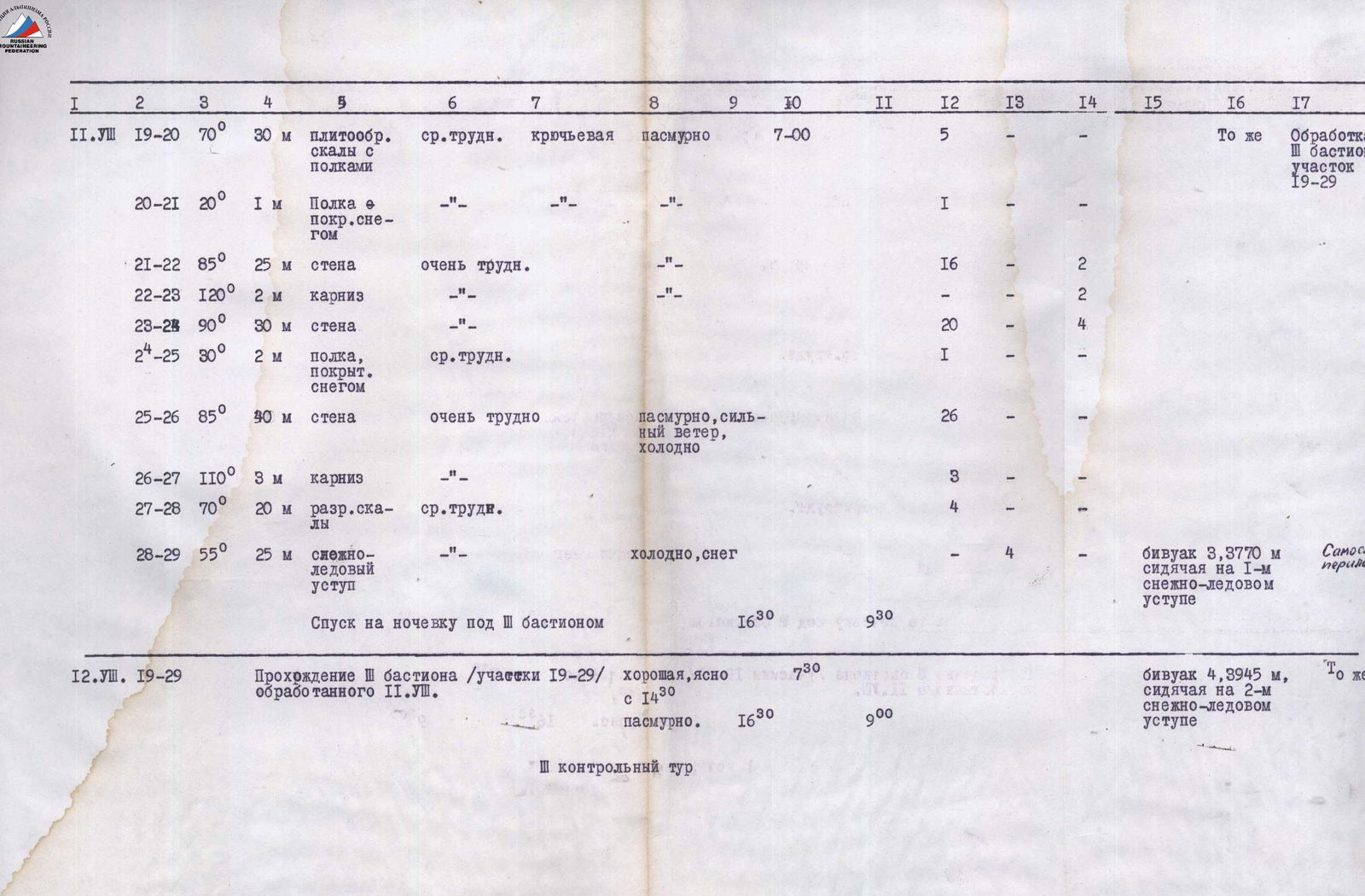
Wake-up at 5:30. Breakfast. Overcast but no precipitation. At 7:00, according to the tactical plan, the duo Popov–Kovtun exits to process the third "bastion."
R19–R20. Плитообразные скалы с полочками 70° — 30 m. Climbing is not difficult. A sufficient number of holds (5 hooks).
R20–R21. Полка covered with rimaye ice and snow 20° — 1 m (1 hook).
R21–R22. Гладкая стена 85° — 25 m. Very difficult climbing. Ladders, platforms (16 rock, 2 expansion bolts).
R22–R23. Двухметровый карниз, крутизной порядка 120°. It is not possible to bypass it. It is necessary to use ladders and expansion bolts (2 hooks).
R23–R24. Отвесная стена. Very difficult climbing 90° — 30 m. Overcome with the help of ladders and a platform (20 rock, 4 expansion bolts).
R24–R25. Полка, покрытая снегом 30°, высотой 2 m. Convenient for organizing rucksack pulling.
R25–R26. Стена 85° — 40 m. Very difficult climbing. Platforms, ladders (26 rock hooks).
R26–R27. Карниз 110° — 3 m. Very difficult but there are cracks for hooks. Passed on ladders (3 hooks).
R27–R28. Разрушенные скалы 70° — 20 m. A large number of holds (3 hooks).
R28–R29. Снежно-ледовый уступ 55° — 25 m. Hook insurance (4 ice hooks).
The rope is fixed, and the duo descends to the overnight stay under the III "bastion" at 16:30 (bivouac 3). Very cold. Snow has started, but hot tea is already ready in the tent, and further dinner is prepared.
The section R19–R29 is completed, with a length of 183 m, using 76 rock, 4 ice, and 8 expansion bolts.
5th day — August 12, 1968
Wake-up at 6:00. Breakfast.
The first participant begins movement along the perlon rope on section R19–R20 at 7:30.
The weather is good. Clear.
Rucksack pulling on sections R21–R24 and R25–R27. At 16:30, we exit onto the snow-ice ledge (bivouac 4 — 3945 m). 2 hours and 30 minutes are spent cutting ice for a platform. We set up a tent, but there is even less space than on the previous bivouac. Dinner. Rest. Self-insurance via a perlon rope.
III control tour.
6th day — August 13, 1968
Wake-up at 5:30. Breakfast. Overcast. At 7:00, the duo Khitrinsky–Baliževsky exits to process the IV "bastion."
R29–R30. Плитообразная стена 85° — 15 m. Very difficult climbing. No holds. Passed on ladders and a platform (11 rock, 1 expansion bolt).
R30–R31. Полка, покрытая снегом 50° — 4 m (1 hook).
R31–R32. Отвесная стена 90° — 30 m. Rocks are very difficult. No holds. Ladders, platforms, few cracks (18 rock, 4 expansion bolts).
R32–R33. Скалы с натёчным льдом 70° — 10 m. Difficult climbing (3 rock hooks).
R33–R34. Стенка 90° — 10 m. Very difficult. местами натёчный лёд. Ladders (7 rock hooks).
R34–R35. Карниз 120° — 4 m — overcome on ladders (4 rock hooks).
R35–R36. Стена с натёчным льдом 80° — 15 m. Very difficult. Ladders, platforms (8 rock hooks).
R36–R37. Плитообразные скалы с полками и большим количеством зацепок 70° — 90 m. Medium difficulty (12 rock hooks).
The rope is fixed, and the duo descends to the bivouac under the IV "bastion" at 18:30 (bivouac 5 — 3945 m). The section R29–R37 is completed, with a length of 178 m. Used:
- 64 rock hooks,
- 5 expansion bolts.
The weather is overcast and windy throughout the day.
7th day — August 14
Wake-up at 5:30. At 6:30, we begin movement along the processed section. We dismantle the bivouac. The weather is good. We pass section R29–R37.
Rucksack pulling on sections:
- R29–R32
- R32–R36
We move another 15 m along the rocky ridge (section R37–R38) and organize an overnight stay under an overhanging rock (bivouac 6 — 4120 m). Setting up a tent is not possible. Dinner is under the open sky, and the overnight stay is as well. Two participants are in a Zdars'ky tent, and four sit wrapped in cloaks. There is no precipitation.
IV control tour in a bank on the wall.
8th day — August 15, 1968
Wake-up at 6:00. At 7:30, we continue movement. Light cloud cover.
R38–R39. Стенка 85° — 8 m. Very difficult (1 hook).
R39–R40. Внутренний угол 90° — 12 m. Ladders, platforms (5 rock, 1 expansion bolt).
R40–R41. Разрушенный скальный гребешок 60° — 90 m. We pass with hook insurance (8 hooks) and exit onto the ridge at 10:30.
R41–R42. Предвершинный гребень, протяжённость порядка 360 m. The complexity of the section is approximately category 4B.
Weather conditions:
- From 11:15, the weather deteriorates.
- Strong wind.
- Blizzard.
At 15:00, we stop for an overnight stay on the summit (bivouac 7 — 4455 m). It is possible to set up a tent. Finally, we can stretch our legs a bit.
The section R38–R42 is completed, with a length of 470 m.
Work on the route:
- 31 rock hooks used,
- 1 expansion bolt used.
Rucksack pulling on section R38–R40.
9th day — August 15, 1968
Descent via the category 4B route to the Chanchakhi–Khokh glacier, passage of the Tsey-Tbilisi pass, and further to the plateau of the Northern circus of the Tsey glacier to the base camp.
A joyful meeting with the observers. It should be noted that the route is very logical, and the path choice after the ice ledge (from bivouac 1) is designated — straight up. Passing the first "bastion" should be done in its right part or closer to the middle. Bypassing the first "bastion" on the left and right is rockfall-prone. The left part of the "bastion" is very complex and is "shot" with rocks when exiting onto the ice ledge (along this path).
The path chosen by the team is safe. Only the last 60–70 m before exiting onto the ridge represent potential rockfall danger since the rocks are heavily deteriorated. However, falling rocks go to the right or left of the central "bastion."
Conclusion on the Route
The route to Chanchakhi–Khokh peak via the central bastion of the Northern wall is logical, beautiful, and very complex. It is replete with various forms of rock relief: sheer walls, overhanging sections, rimaye ice cover, etc.
The route was fully completed in accordance with the tactical plan of ascent. The actual time distribution for the movement showed that the tactical plan was well-prepared, indicating a good knowledge of the route and high qualification of the climbers.
The main part of the route (before exiting onto the ridge) has a height difference of around 750 m with an average steepness of 72°.
The presence of two snow-ice ledges and a ledge between the "bastions" allowed for the organization of satisfactory overnight stays. The more than two-hour effort spent on cutting ice platforms was justified by the relative "comfort" during rest.
The most complex sections are the I and III bastions and the beginning of the IV bastion. Passing these sections requires excellent rock climbing technique. To ensure safe passage of the route, it is necessary to have:
- rock hooks of the widest assortment,
- expansion bolts,
- wooden and duraluminum wedges,
- ladders,
- platforms.
Main technical characteristics of the route:
- total ascent length — 1200 m,
- total route length from the bergschrund to the ridge — 835 m,
- height difference of the route from the bergschrund to the ridge — 750 m,
- height difference of the most complex sections — 310 m,
- average steepness of the wall from the bergschrund to the ridge — 72°,
- steepness of the most complex sections — 85–110°,
- number of hooks used on the route — 224:
- different rock hooks — 51,
- duraluminum and wooden wedges — 26,
- expansion bolts — 9,
- ice hooks — 9.
Not included is the number of hooks for ensuring safety and the possibility of pulling up rucksacks, organizing bivouacs, and descending from the summit;
- time spent on walking hours — 82 hours (excluding approaches and descent).
To pass this route, technical and tactical maturity of the participants and high moral and psychological preparation are necessary, as well as sufficient experience in organizing sitting and hanging bivouacs.
Comparing the route with previously traversed wall routes of category 5B, the team evaluates this route as a route of the highest category of difficulty.
| TEAM CAPTAIN | L. POPOV |
|---|---|
| SENIOR COACH, | |
| HONORED COACH OF UKRAINIAN SSR, MASTER OF SPORTS OF THE USSR | V. OVCHAROV |
| TEAM COACH, MASTER OF SPORTS OF THE USSR | Yu. MELNIK |
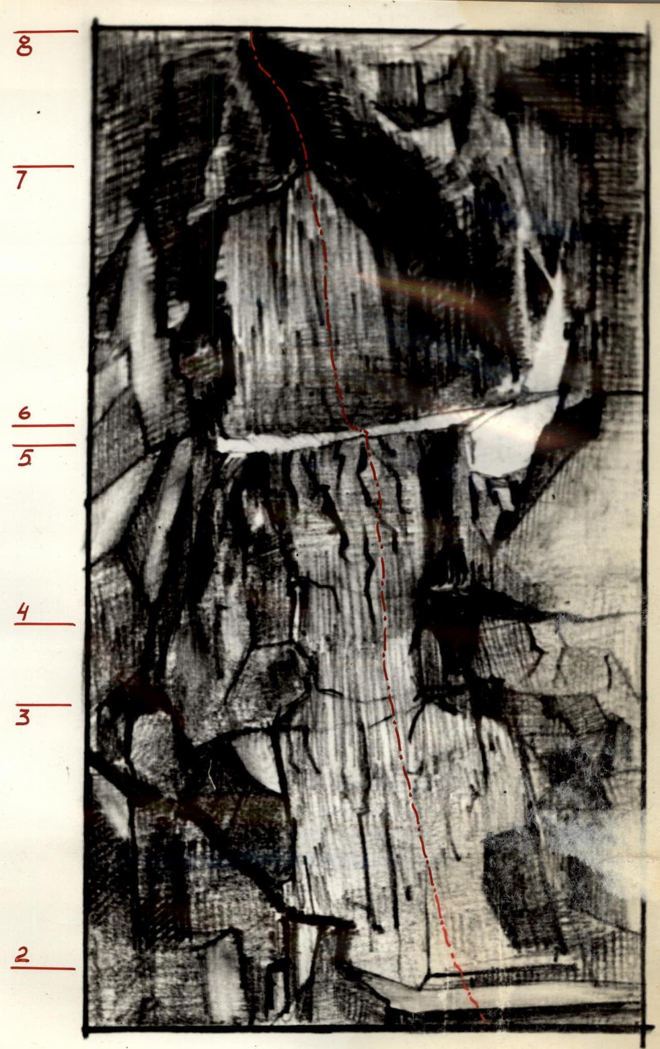
Section R2–R8
Table
Main Characteristics of Ascent Routes
Ascent route — Chanchakhi–Khokh via the central "bastion" of the Northern wall. Height difference of the Northern wall (from the bergschrund to the summit) — 1000 m. Height difference from the bergschrund to the exit onto the ridge — 750 m. Including the most complex sections — 310 m. Steepness of the route from the bergschrund to the exit onto the ridge — 72°. Steepness of the most complex sections — 85–110°. Average steepness of the ridge — 45–50°.
| Sections | Average Steepness of Section | Length of Section | By Character of Relief | By Technical Difficulty | By Methods of Passage and Insurance | By Weather Conditions | Time of Stop for Bivouac | Time of Departure | Walking Hours | Rock Hooks | Ice Hooks | Expansion Bolts | Bivouac Conditions | Weight of Daily Provisions | Notes | |
|---|---|---|---|---|---|---|---|---|---|---|---|---|---|---|---|---|
| 1 | 2 | 3 | 4 | 5 | 6 | 7 | 8 | 9 | 10 | 11 | 12 | 13 | 14 | 15 | 16 | 17 |
| 8.VIII | R0–R1 | 50° | 40 m | icy slope | average difficulty | hook insurance | good, clear | 6:30 | 4 | 850 g per person or about 5 kg per day for the whole team | Section R0–R9 processed on 8.VIII. | |||||
| R1–R2 | 60° | 20 m | rocks covered with snow | 4 | ||||||||||||
| R2–R3 | 85° | 30 m | wall | very difficult, ladders | 8 | 2 | ||||||||||
| R3–R4 | 70° | 8 m | slab | difficult | 2 | |||||||||||
| R4–R5 | 80° | 10 m | wall | difficult | 3 | |||||||||||
| R5–R6 | 30° | 2 m | ledge | average difficulty | 1 | |||||||||||
| R6–R7 | 90° | 20 m | wall | very difficult, ladders | 14 | 2 | ||||||||||
| R7–R8 | 80° | 12 m | inner corner | very difficult, ladders | overcast | 4 |
| Sections | Average Steepness of Section | Length of Section | By Character of Relief | By Technical Difficulty | By Methods of Passage and Insurance | By Weather Conditions | Time of Stop for Bivouac | Time of Departure | Walking Hours | Rock Hooks | Ice Hooks | Expansion Bolts | Bivouac Conditions | Weight of Daily Provisions | Notes | |
|---|---|---|---|---|---|---|---|---|---|---|---|---|---|---|---|---|
| 1 | 2 | 3 | 4 | 5 | 6 | 7 | 8 | 9 | 10 | 11 | 12 | 13 | 14 | 15 | 16 | 17 |
| 9.VIII | R0–R8 | Sections processed on 8.VIII are passed | good | 6:00 | good in base camp on plateau, height 3530 m | |||||||||||
| R8–R9 | 80° | 25 m | wall | difficult | overcast | 8 | ||||||||||
| R9–R10 | 65° | 6 m | slab | hook insurance | 1 | |||||||||||
| R10 |
Footnotes
-
{ }^{1}
 ↩
↩
Comments
Sign in to leave a comment