
Report
On the first ascent to the summit of Chan Chakhi-Khokh (4453 m) via the route: North wall - right "bastion", from August 18 to 26, 1965. By the team of Kharkov regional council of the sports society "Avangard" led by NEBORAK V.S.

Mt. CHAN CHAKHI-KHOKH 4453 m.
Team Composition
Leader: NEBORAK VALENTIN STEPANOVICH, born in 1930, Ukrainian, member of the CPSU, 1st sports category in mountaineering, architect.
Participants:
GRIGORENKO-PRIGODA YURIY IVANOVICH, born in 1935, Ukrainian, non-partisan, 1st sports category in mountaineering, electrical engineer.
BOLIZHEVSKIY YURIY KONSTANTINOVICH, born in 1933, Russian, non-partisan, Master of Sports of the USSR in mountaineering, radio engineer.
OLEYNIK LINA DANILOVNA, born in 1932, Ukrainian, non-partisan, Master of Sports of the USSR in mountaineering, radio engineer.
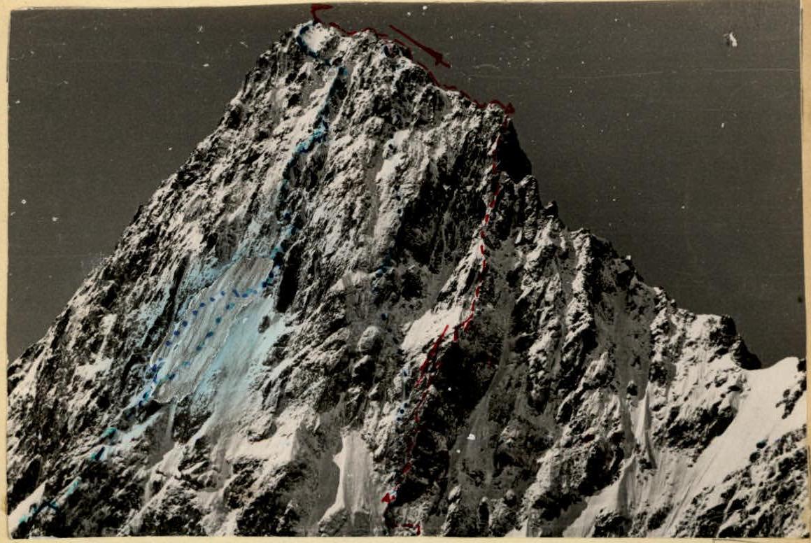 Mt. CHAN CHAKHI-KHOKH. Shot from the summit of Dubль-Pik.
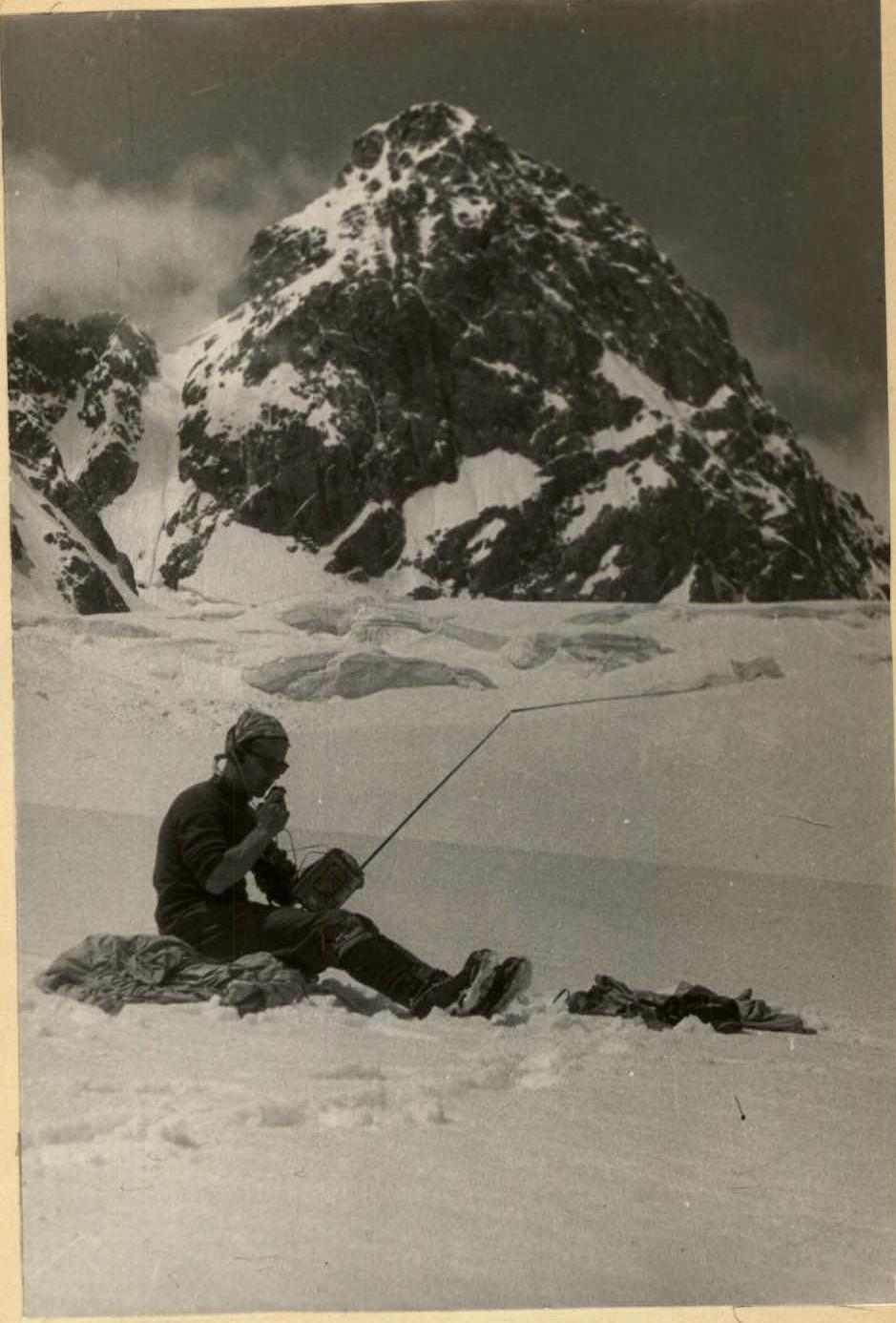 Reconnaissance sortie. Checking the possibility of radio communication from the North circus of Tsey glacier with a/l "Tsey".
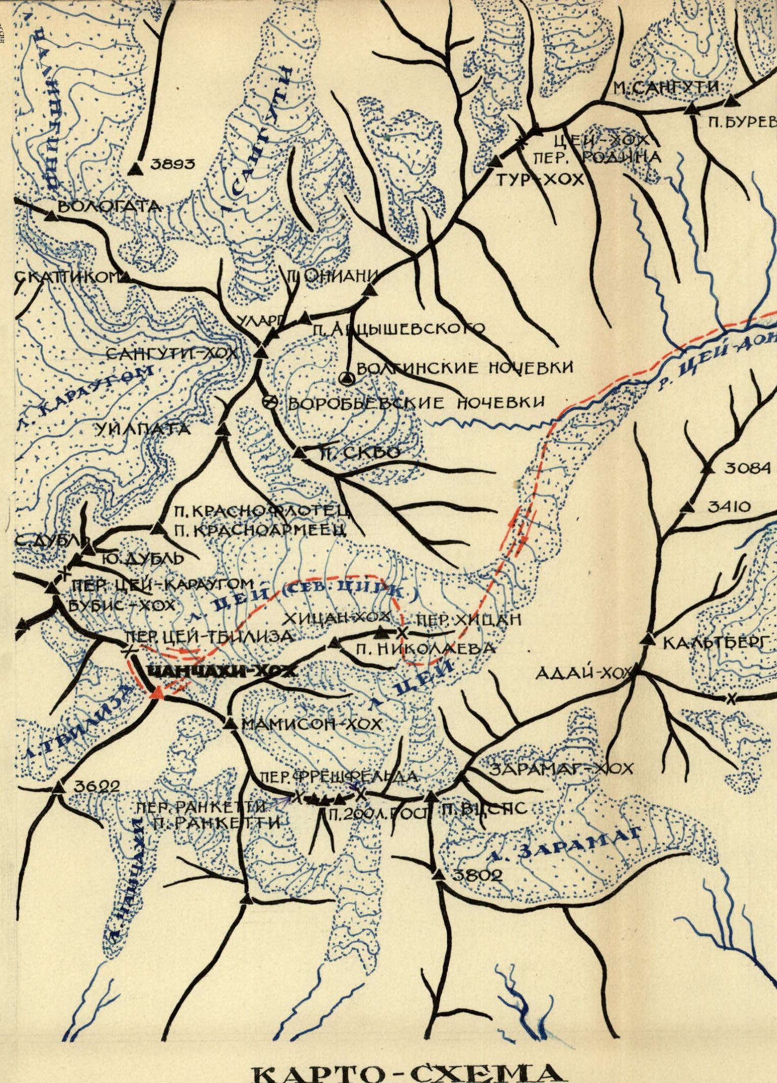 MAP-SCHEME OF THE ASCENT AREA
Route Description
From the "Tsey" alpine camp, we follow the trail to the Tsey glacier, through the "ram's foreheads" and via the Khitsan pass, we exit into the North circus of the Tsey glacier and, in the middle of the glacier, we reach the upper plateau of the North circus of the Tsey glacier under the northern wall of the Chan Chakhi-Khokh peak. From the alpine camp to the bivouac on the upper plateau, it takes about 10 hours. From the plateau, we ascend a snow slope with an initial incline of 15–20° and up to 70–80° when approaching the bergschrund to reach a rocky island located under the right bastion. The bergschrund (R2) is passed directly under the rocks using ice axes, ice hooks, and step cutting. From the bergschrund, we ascend an ice slope (R3) to reach the rocks. The rocks are steep (R4), with complex climbing; ladders can be used, and ice hooks are used in the rocks. The rocky wall (R4) leads to the upper part of the 1st rocky island; the rocks become gentler (R5) and lead to rocks with an incline of 50–55°, covered with ice accretion; it is necessary to work in crampons since after the rocks, there is a section with ice accretion (R6) with an incline of 60° and a length of 50 meters; crampons hold poorly, so it is necessary to cut steps and frequently hammer in ice hooks. The ice slope leads to very destroyed and almost sheer rocks of the 2nd rocky island (R7 and R8). We carefully pass the rocky wall (additional hooks need to be hammered in for directional rope to avoid dislodging rocks during belaying) and exit onto shelves under the base of the bastion. We traverse left, bypassing the bastion at its very base (R9–R10), and exit onto rocky steps (R10) at the base of the chimney located on the left wall of the right bastion. Here, it is possible to organize an overnight stay under cover. A control cairn is laid at the site at the base of the chimney. The further path goes through a 100-meter chimney (R11). Climbing is very complex due to the chimney's plugs and smooth walls. Ladders are used, especially when overcoming plugs. It is necessary to exit the chimney after about 100 meters, although the chimney continues further, and exit onto a bridge to the right of the chimney under an overhanging finger. Here, it is convenient to gather and receive backpacks. Under the finger, there is also a cairn. From the finger, via a 30-meter sheer wall (R13), we exit into the upper part of the 1st stage of the bastion; it is convenient to pull up backpacks and gather for an overnight stay. From the overnight stay, via rocks with an incline of 50° (R14) - in some places, these are strongly destroyed rocky steps standing in blocks "alive," and in some places - rocks covered with ice accretion. These rocks lead to a steep ascent of the 2nd stage of the bastion (R15), passed via an internal corner with a crack (R15). Complex climbing. At the top of the second stage, there is a site convenient for receiving backpacks. Via rocks (R16), similar to section R14, we approach the 3rd stage of the bastion. The 3rd stage is passed via a wall with a crack, which, after about 50 meters, has a spalled stone for receiving backpacks, but there is no place to gather - it's simply a convenient point for re-attaching. Further along the wall, we exit onto a tower standing on the ridge leading from the summit to the Tsey-Tbilisi pass. From the tower to the summit, it takes 2 hours of work with alternate belaying via ledges. Descent is via route 4B category of difficulty and through the Tsey-Tbilisi pass onto the plateau of the North circus of the Tsey glacier. Return to the camp is via the Khitsan pass.
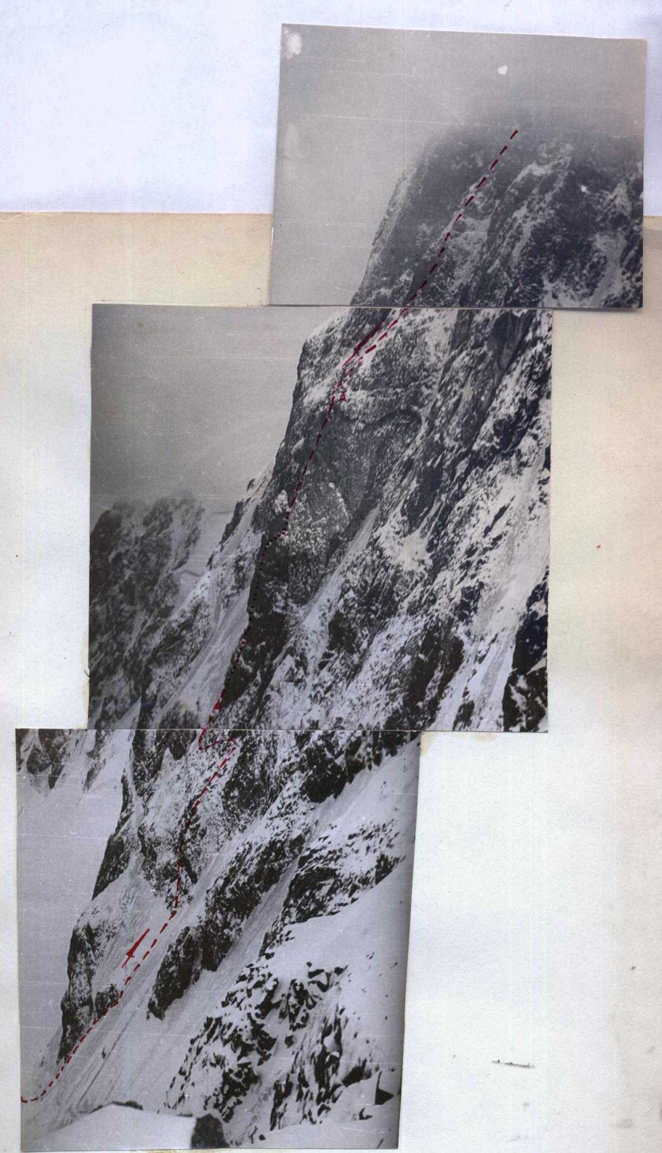 ROUTE PROFILE (SHOT FROM THE TCEY–TBILISA PASS). AVERAGE STEEPNESS OF THE ROUTE - OVER 70° (SEE TABLE).
TABLE
Main characteristics of the ascent route.
Ascent route: Chan Chakhi-Khokh peak (4453 m) via the north wall, right "bastion".
Height difference 850 m, including complex sections 630 m.
Route steepness over 70°.
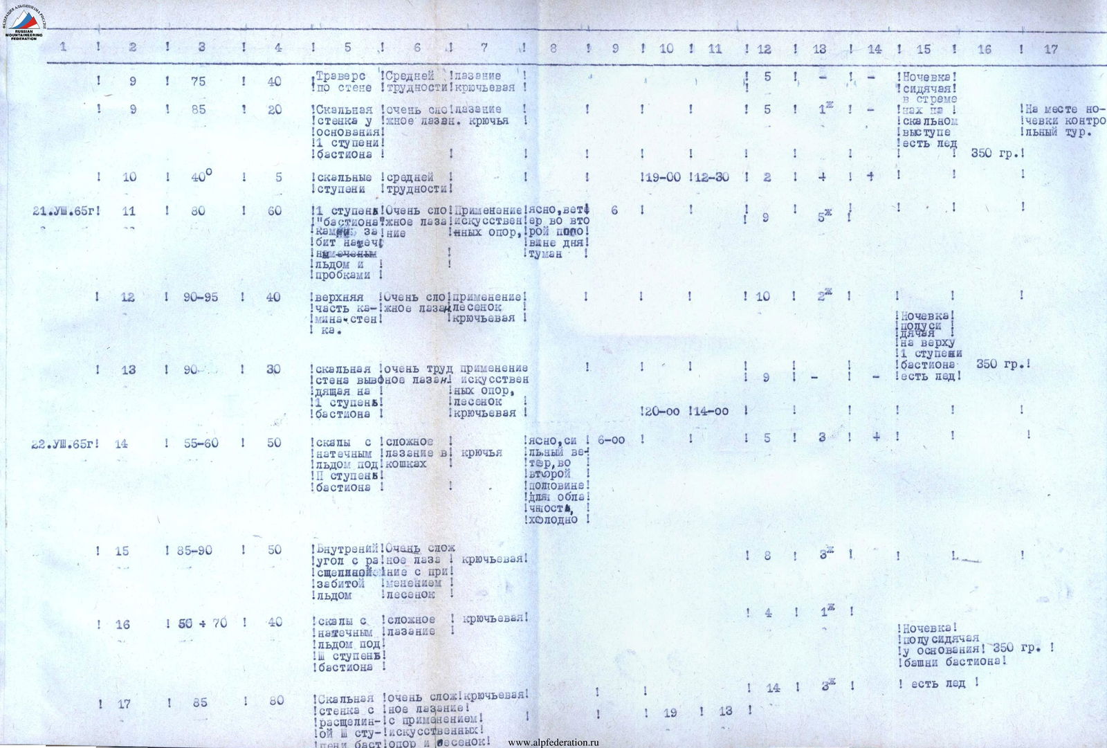
| Date | Section | Steepness | Length, m | Section Characteristics and Passage Method | Weather | Time, h:min | Rock Hooks | Ice Hooks | Piton Hooks | Overnight Conditions / Remarks |
|---|---|---|---|---|---|---|---|---|---|---|
| 19.08.1965 | R0 | 10–20° | 200 | Snow plateau. Simultaneous movement. | Good | 5:30 | Route reconnaissance was performed. Ropes were hung on sections R1–R5. | |||
| R1 | 20–70° | 40 | Snow slope. Step cutting. | 4 | ||||||
| R2 | 5 | Bergschrund. Ladder used, ice hooks. | 3 | |||||||
| R3 | 60–70° | 12 | Ice slope. Medium difficulty, crampons with step cutting, ice and rock hooks. | 1 | 2 | |||||
| R4 | 80° | 60 | Rocky walls with ice accretion. Complex climbing with ladder use, hooked. | 9 | 4 | On the Tsey glacier plateau, North circus. Rations: 1 kg. | ||||
| R5 | 55° | 20 | Rocks with ice accretion. Medium complexity, hooked. | 1:12–16:30 | 3 | 1 | 1 | |||
| 20.08.1965 | Section R0–R5 | Passed via hung ropes. | 5:30 | |||||||
| R6 | 60° | 50 | Ice accretion. Step cutting in crampons. | Clear in the morning, wind, fog in the second half of the day. | 10 | |||||
| R7 | 80° | 20 | Rocky wall. Complex climbing. Hooked. | 4 | 1 | 1 | ||||
| R8 | 85° | 30 | Very destroyed rocky wall. Very complex climbing. Hooked. | 6 | 2 | 1 | ||||
| R9 | 85° | 15 | Rocky. Very difficult climbing. Hooked. | 14 | ||||||
| 21.08.1965 | R9 | 75° | 40 | Traverse along the wall. Medium difficulty, hooked. | 5 | 1 | Overnight stay in stirrups. | |||
| R9 | 85° | 20 | Rocky wall at the base of R1 stage of the bastion. Very complex climbing, hooks. | 15 | 1 | On the rocky ledge, there is ice. Control cairn at the overnight site. Rations: 350 g. | ||||
| R10 | 40° | 5 | Rocky steps. Medium difficulty. | 1:19–12:30 | 2 | 1 | 4 | |||
| R11 | 80° | 60 | R1 stage of the "bastion" chimney. Very complex climbing, artificial support, via pre-laid ropes, ice, and plugs. | Clear, wind in the second half of the day, fog. | 6 | |||||
| R12 | 90–95° | 40 | Upper part of the chimney-wall. Very complex climbing, ladders, hooked. | 10 | 2 | 1 | Overnight stay semi-sitting at the top of R1 stage of the bastion. | |||
| R13 | 90° | 30 | Rocky wall leading to R1 stage of the bastion. Very difficult climbing, artificial support, ladders, hooked. | 1:20–1:40 | R1 stage of the bastion, there is ice. Rations: 350 g. | |||||
| 22.08.1965 | R14 | 55–60° | 50 | Rocks with ice accretion. Complex climbing in crampons, hooked. | Clear, strong wind, cloudy in the second half of the day, cold. | 6:00 | 15 | 3 | 4 | |
| R15 | 85–90° | 50 | Internal corner with a crack filled with ice. Very complex climbing with ladder use, hooked. | 18 | 3 | 1 | ||||
| R16 | 50–70° | 40 | Rocks with ice accretion under R3 stage of the bastion. Complex climbing, hooked. | 4 | 1 | 1 | Overnight stay semi-sitting at the base of R3 stage of the bastion, there is ice. Rations: 350 g. | |||
| R17 | 85° | 80 | Rocky wall with a crack R3 stage of the bastion. Very complex climbing with artificial support and ladder use, hooked. | 19 | 13 | 1 | ||||
| 23.08.1965 | R17 | 90° | 50 | Rocky wall leading to the tower of the bastion (from the northwest). Approaches the ridge 4B category of difficulty. Very complex climbing with artificial support and ladder use, hooked. | Good | 7:00 | 1 | 8 | 2 | Overnight stay on the ridge leading from the Tsey-Tbilisi pass, lying down, there is ice. Rations: 350 g. |
| 24.08.1965 | R18 | Ridge 4B category of difficulty, leads to the summit. Leaving the bivouac at 10:00, the group reached the summit by 12:00. | Cloudy in the second half of the day, fog. | Descent to the tent via the ascent route, then south to the Chan Chakhi glaciers. Overnight stay on a counterfort, not reaching the glacier. | ||||||
| 25.08.1965 | R19 | Exit to the Tsey-Tbilisi pass. | Severe weather conditions: visibility 10–15 meters, strong wind, snowfall. | Overnight stay on the pass. | ||||||
| 26.08.1965 | Descent from the pass and return to the Tsey alpine camp. |
The team spent 55 hours on the route (via the "bastion"). To ensure safety, 147 hooks were hammered in. Including: rock hooks - 99 pcs., ice hooks in rocks - 25, ice hooks in ice - 18, wedges - 5 pcs. In addition to the specified quantity, 47 rock hooks were hammered in for handrails during overnight stays, and 39 rock and ice hooks were hammered in during descent. Ice hooks were hammered into rocks.

Comments
Sign in to leave a comment