Report
On the Ascent
FOR THE 1970 USSR ALPINISM CHAMPIONSHIP BY THE TEAM FROM THE "TSEI" ALPINE CAMP UNDER THE CENTRAL COUNCIL OF THE "TRUD" SPORTS SOCIETY TO THE SUMMIT OF CHANCHAKHI-KHOKH (4420 m) VIA THE NORTH FACE (NORTHEAST FACE OF THE CENTRAL BASTION) (FIRST ASCENT)
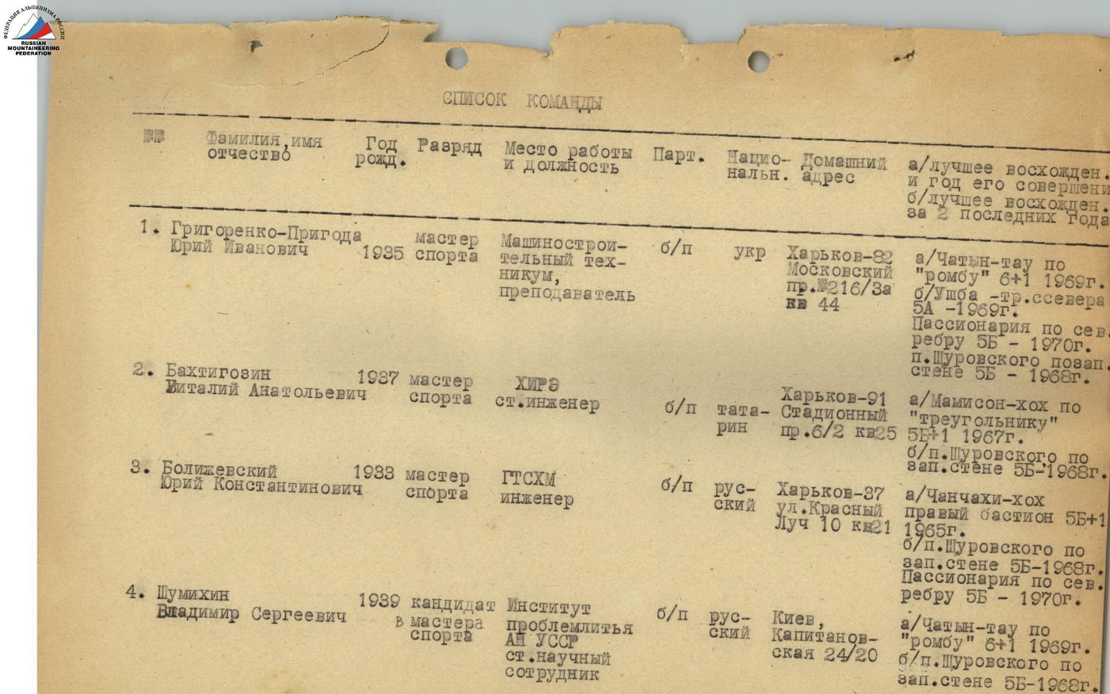
Team Captain: GRIGORENKO-PRIGODA Yu.I.
Team List
| № | Surname, First Name, Patronymic | Year of Birth | Rank | Place of Work and Position | Party Membership | Nationality | Home Address | a/Best Ascent and Year; b/Best Ascent in the Last 2 Years |
|---|---|---|---|---|---|---|---|---|
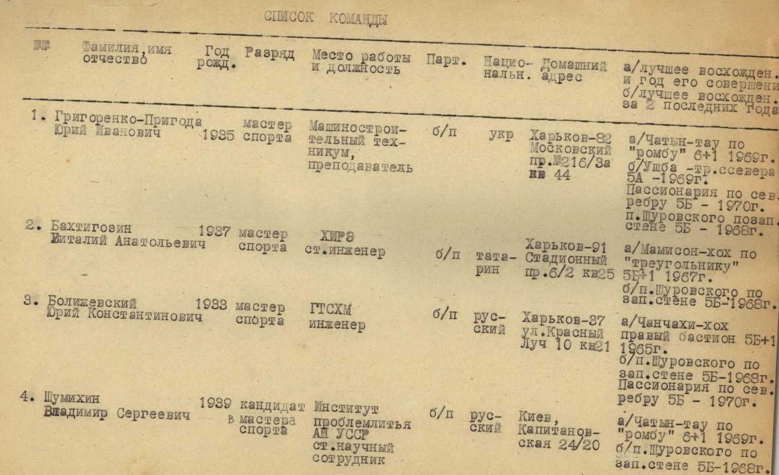
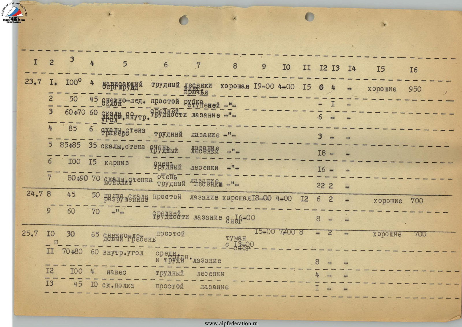
| Date | R-Sections | Average Slope of Section, ° | Length of Section, m | Terrain Characteristics | Technical Difficulty | Method of Overcoming and Belaying | Weather Conditions | Time of Bivouac |
| ---- | :-------- | :-------------------------- | :------------------------------: | :------------------- | :----------------------- | :------------------------------------- | :----------------- | :------------------------ |
| 23.07 | R1 | 100 | 4 | Overhanging | Difficult | Ladders | Good | 19:00 |
| R2 | 50 | 45 | Snow-Ice | Easy | Ice Axe | – | ||
| R3 | 60–70 | 60 | Rocks, Inner Corner | Medium | Climbing | – | ||
| R4 | 85 | 6 | Rocks, Wall | Difficult | Climbing | – | ||
| R5 | 85–85 | 35 | Rocks, Wall | Very Difficult | Ladders | – | ||
| R6 | 100 | 15 | Cornice | Very Difficult | Ladders | – | ||
| R7 | 80–90 | 70 | Rocks, Wall | Very Difficult | Climbing | – | ||
| 24.07 | R8 | 45 | 50 | Shelf, Rocks | Easy | Climbing | Good | 18:00 |
| R9 | 60 | 70 | – | Medium Category | Climbing | Snow, 16:00 | ||
| 25.07 | R10 | 30 | 65 | Snow-Ice Ridge | Easy | – | Fog from 13:00, Snow | 15:00 |
| R11 | 70–80 | 60 | Inner Corner | Medium and Difficult Category | Climbing | – | ||
| R12 | 100 | 4 | Overhang | Difficult | Ladders | – | ||
| R13 | 45 | 10 | Rock Shelf | Easy | Climbing | – | ||
| 26.07 | Transition to Snow-Ice Ridge R15 | Snow, Sleet, 10:00 | 14:00 | |||||
| 27.07 | R16 | 70 | 15 | Rock Blocks | Difficult | Climbing | Snow, Sleet, 18:00 | 9:00 |
| R17 | 90–95 | 20 | Monolith, Crack | Difficult | Climbing | – | ||
| R18 | 85–95 | 20 | Monolith | Very Difficult | Pendulum Traverse, Climbing | – | ||
| R19 | 60–70 | 50 | Inner Corner | Difficult | Climbing | – | ||
| R20 | 75–80 | 65 | Inner Corner, Ice-Covered | Very Difficult | Climbing | – | ||
| 28.07 | R21 | 60–70 | 50 | Wall with Shelves | Medium Category | Climbing | Snow from 13:00 | 15:00 |
| R22 | 80–100 | 30 | Wall, Cornice | Very Difficult | Ladders | – | ||
| R23 | 70 | 20 | Walls | Medium Difficulty | Climbing | – | ||
| R24 | 60 | 20 | Ridge | Easy | Climbing | – | ||
| 29.07 | Entire day with night snowstorm, transition to section R19 | Snowstorm | 15:00 | |||||
| 30.07 | R25 | 40–50 | 50 | Wall of Medium Difficulty | Climbing | Snow, Sleet, Icy Rocks and Rope | Snow, Sleet, 7:00 | 19:00 |
| 31.07 | R26 | 20–30 | 250 | Rocks, Easy and Icy | Medium Difficulty | Climbing, Good | Ascent to Summit, 12:00 | 9:00 |
Order of Route Passage. Route Description
- July 19, 1970 — The team left the "Tsei" alpine camp and returned to the hut under Peak Nikolaeva. The weather was bad, and they did not proceed further that day.
- July 20 — Through the Khitsan pass, they moved to the north cirque of the Tsei glacier under the wall of Chanchakhi-Khokh, transferred all the gear, and returned to the hut due to bad weather.
- July 21 — They moved under the wall and set up a camp.
- July 22 — A day of observing the route. The weather was good — clear.
- July 23 — A day of processing the route.
The entire route can be divided into three sections for convenience: I, II, III. All sections are approximately equal in length — 300 m.
- Section I — The rock "triangle" at the base of the bastion.
- Section II — The middle part of the bastion wall, dissected by three narrow shelves.
- Section III — The wall of the upper part of the bastion.
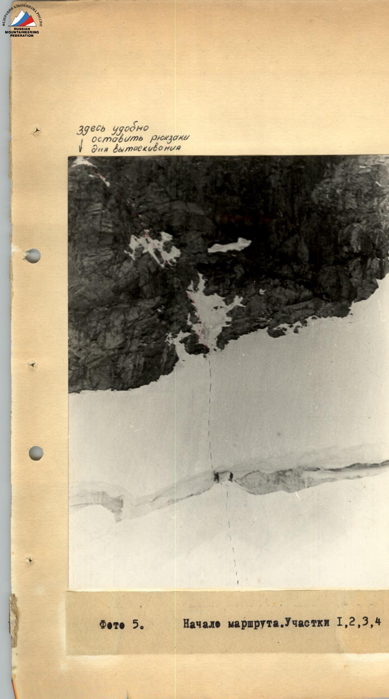
Section I — The rock triangle at the base of the bastion features sheer walls with overhanging sections. On the left, the triangle is bounded by couloirs with drops from the central snow patch. At the top right, the triangle is bounded by a long, narrow shelf descending as a snow field under the right bastion. At the lower right end of the shelf is a rock island: to the right of the island is the start of the route to the right bastion, and to the left is the start of the central bastion route (Popov's route). In the middle of the base of the triangle, rocks with shelves leading left and upwards are visible, marking the beginning of the route (photo).
The route begins with overcoming the bergschrund; this summer it was complex, and a hole had to be dug out in the overhanging edge (photo). Then, movement straight up the snow-ice slope (R2) onto the rocks. The first 50 m of rocks lead upwards slightly to the left (R3) (photo 3.5); the rocks are not complicated, with many small shelves, and after 6 m lead to overhanging rocks — there are no simple paths further. The section ends with a narrow horizontal shelf turning into a balcony on the right (a control cairn is left as a landmark on the route). About 6 m before this shelf, there is a platform where backpacks can be left for hauling.
Photo 5. Beginning of the route. Sections R1, R2, R3, R4.
Here, backpacks can be left for hauling.
From the balcony — a complex traverse to the right (R4); the wall is monolithic, almost without handholds, leading to a sharp inner corner where movement upwards is very challenging (R5), requiring the use of ladders, with sections having overhanging parts. The inner corner leads under a cornice with horizontal and vertical cracks (R6). To the right, smooth walls diverge, and under the cornice, there is a decent shelf where backpacks can be pulled up by rope.
From this shelf, the vertex of the triangle can be seen slightly to the left. The path should be directed towards it, exiting onto a shelf slightly to the right of the triangle's vertex. The rocks are monolithic, with places to drive pitons. The wall (R7) leads to the upper part of the long snow shelf. Processing of the route was completed here.
Processing took 15 hours for two pairs working alternately (from 4:00 to 19:00). Along the ropes, this is 5 × 50 m. The last pair returned to the tents on the plateau at 20:00 on July 24.
- At 4:00, they started on the route.
- The traverse took 8 hours.
- At 12:00, they reached the shelf and soon found a safe place to set up a bivouac 50 m to the left along the shelf (R8) — here, the 2nd control cairn was left.
Section II
July 25 — They set out to further process the route. The weather was not promising. They did not dismantle the bivouac. After the processed ropes, they reached the snow (R10) and then the inner corner.
Between the inner corner and the bastion ridge, there is a wall dissected by three narrow shelves:
- The third shelf on the right has the 2nd snow comb;
- The comb is narrow and steep;
- It is possible to set up a comfortable bivouac on it.
The comb is slightly off the direct path upwards but is justified by the convenience of the bivouac. Here is the control point of Popov's route; we also left a roll with a note.
Section up to R15. The walls between the shelves are traversed by free climbing, with some challenging sections. The direction of movement is very clear. Leaving the tent at 7:00 and working in two teams, they reached the 2nd snow comb by 13:30 and began preparing a site. With good weather, they planned to move here; however, the weather worsened significantly, and they remained at the previous bivouac for the night.
July 26 — The weather is bad; they dismantled the bivouac and began transitioning to the 2nd snow comb. By 14:00, they reached the comb and set up a bivouac. Preparing the bivouac took about 2 hours. The site was lying down, but sleet was falling from the walls, requiring frequent clearing.
July 27 — From the comb, 10–15 m further, Popov's route turns down to the right; after about 20 m, a bend is visible; their path goes left upwards. There is no easy transition to the left — the wall is monolithic, resembling tiles. Possibly, with good weather, a very challenging climb could make the transition to the left.
They had to:
- Climb up the wall with a vertical crack (R16 and R17), 35 m;
- Then make a 20-meter pendulum traverse to the left (R18).
The control point (to a spot that from the side looks like a shelf) — large rock blocks. Further movement goes along the left wall of the bastion via an inner corner (R19), partially covered in ice (115 m). For the night, they returned to the comb.
July 28 — Then, they had to climb a wall (R21) leading to a 30-meter wall with a cornice (R22). The cornice marks the end of the challenging wall of the bastion. Beyond that, the ascent to the ridge is not complicated. They returned late from processing and stayed at the previous bivouac.
July 29 — The entire day was a snowstorm, but they set out and advanced to R19. Working was very difficult due to ice-covered rocks and ropes; ice axe holds were poor, and ropes were heavy and did not pass through carabiners. They set up a bivouac on the shelf (R19).
July 30 — The weather remained bad with no signs of improvement. However, since the ropes were almost at the ridge, they proceeded to work. Progress was slow due to the need for careful safety measures. By 17:00, they passed the bend of the bastion wall, collected excess gear into one backpack (4 ropes, carabiners, pitons), and contacted the observers via radio. They reported that the dropped gear landed right next to them.
After the bend of the wall, the path to the ridge is not complicated but was challenging this year. At 19:00, they reached the ridge and began preparing a bivouac. By 20:00, a sitting bivouac was ready. It quickly became cold and cleared up towards night.
July 31 — The weather was good — clear and cold. The ridge, familiar as easy (they had climbed it in 1965 after the right bastion), was now covered in dry, loose snow and icicles, requiring serious effort. At 12:00, they reached the summit.
The descent path was known to them:
- From the summit along the ridge to the needle, 50 m;
- Then 20 m of sporty descent;
- Another 100 m along the ridge;
- Then right along the rock combs to the plateau under the Tsei-Tbilisi pass.
They descended to the plateau by 18:00 and stopped for the night.
August 1 — Through the Tsei-Tbilisi pass and the Khitsan pass, they returned to the "Tsei" alpine camp by 17:00. The time spent on the route from plateau to plateau was 87 working hours. 215 pitons were driven, including those for the descent and passage through the Tsei-Tbilisi pass.