Ukrainian Council of the "Burevestnik" Sports and Recreation Society Mt. UlarG, 4320 m, via the bastions of the North Face
Team Composition:
-
- Bodnik V.N.
-
- Bychek A.M.
-
- Barsukov V.A.
-
- Bozhko I.V.
-
- Derkach A.A.
-
- Kharianyk I.V.
1980
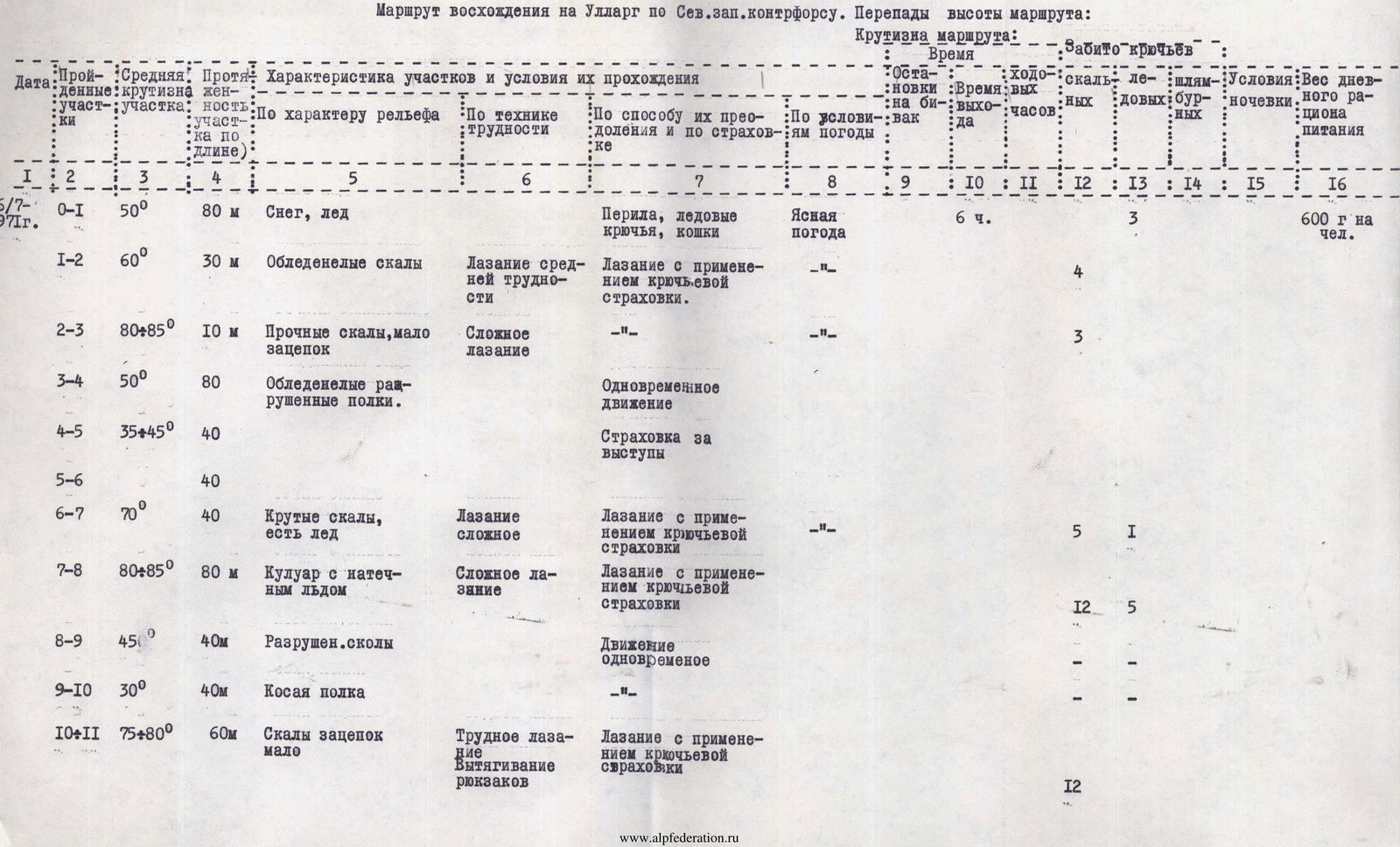
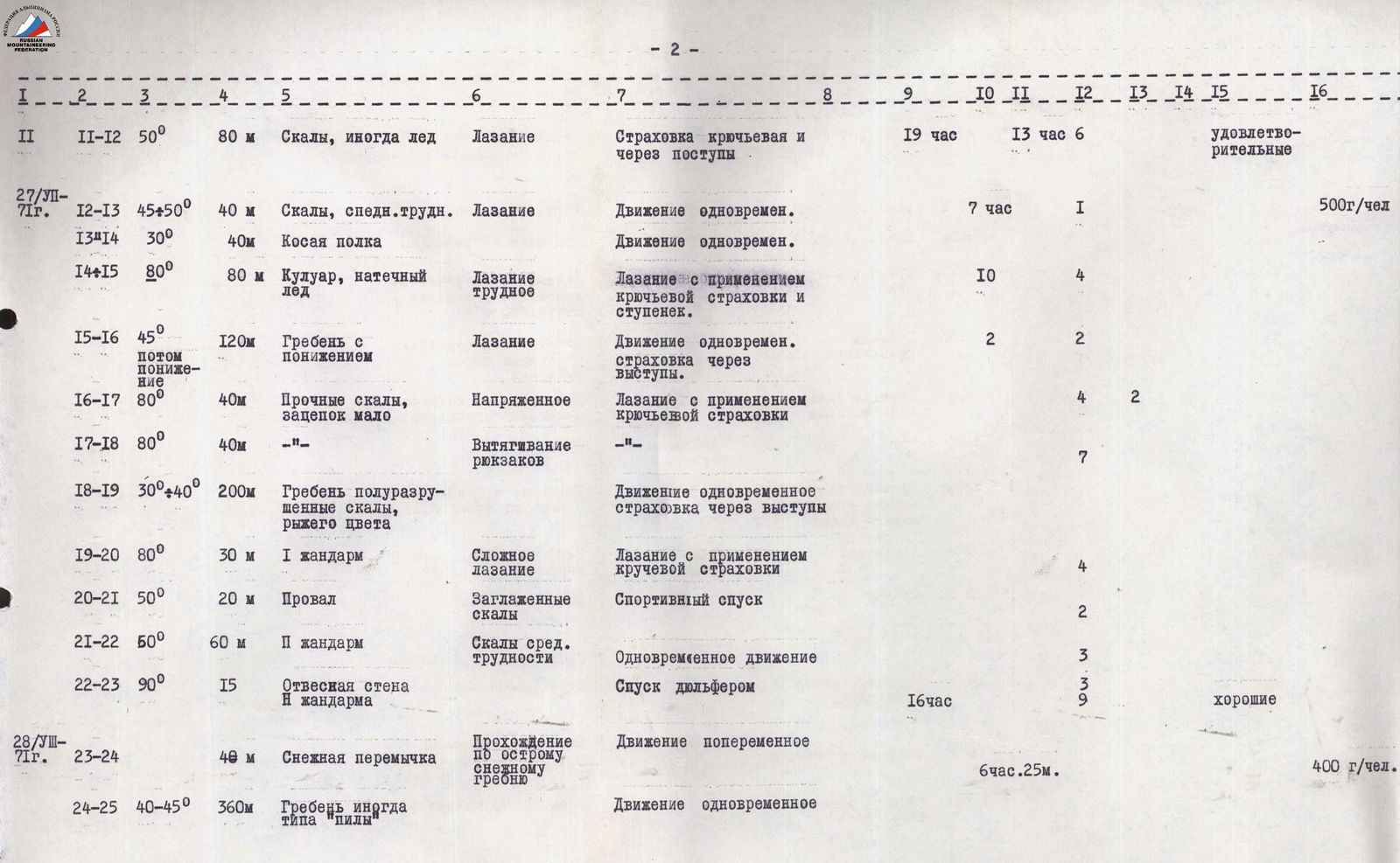
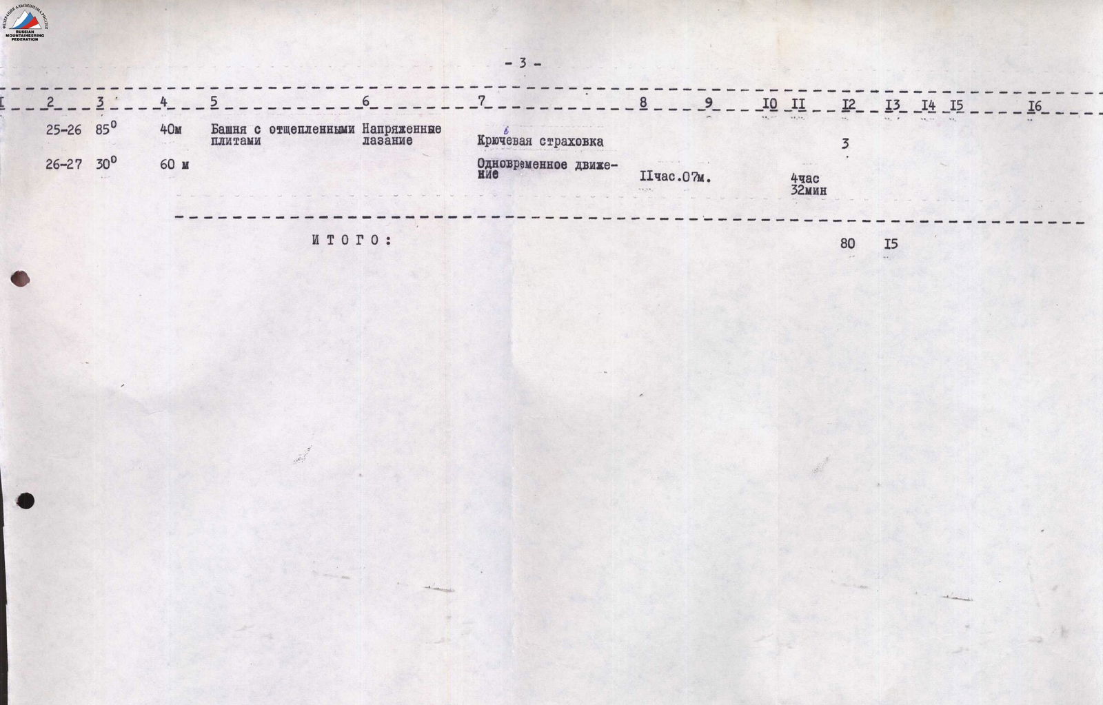
TABLE OF MAIN CHARACTERISTICS OF THE ASCENT ROUTE
The ascent route to UlarG via the NW counterfort. Elevation differences of the route:
Protocol
Analysis of the ascent to Mt. UlarG via the bastions of the North Face (first ascent), made by the team of the Ukrainian Republican "Burevestnik" Sports and Recreation Society, consisting of:
- Bodnik V.N. — Master of Sports of the USSR — team leader
- Bychek A.M. — Master of Sports of the USSR
- Barsukov V.A. — Candidate Master of Sports
- Bozhko I.V. — Candidate Master of Sports
- Derkach A.A. — Candidate Master of Sports
- Kharianyk I.V. — Candidate Master of Sports
Attendees: Rudnev D.Ya. — representative of the KSP of the Tsey region, Akrritov I.P. — head of the training department of the "Torpedo" alpine camp, I releasing Khromov V.K. — detachment commander, II releasing Belyaev Yu.S. — head of the rescue detachment of the camp, instructors of the camp: Master of Sports of the USSR Kovtun V.G., Master of Sports of the USSR Fomin A.S., participants of the ascent.
Speakers: ascent leader — Bodnik V.N.
Preparations for the ascent to Mt. UlarG via the North Face began in advance. In the 1979 season, a reconnaissance trip was made under the wall, it was photographed, and a probable path was determined. The entire North Face of Mt. UlarG is highly complex, and even the easiest path can be climbed by a highly qualified group. The route chosen by our group is combined and, in the opinion of all participants of our ascent, is the most difficult and interesting on the North Face. (200 meters)
It is logical, the path goes almost in a straight line with an exit to the summit. The lower part of the route is an ice slope with a steepness of 55–60°. Further, the route goes through four clearly defined bastions.
The first bastion, approximately 120 m long, has an average steepness of about 70°. The rocks are heavily fragmented, with a large number of loose stones, which requires great caution when passing this section. Its technical complexity can be estimated as 4–5.
The second bastion is approximately the same length, but slightly steeper — about 75°. The rocks are stronger, but climbing is more difficult (5).
The third bastion (approximately 100 m) has a steepness of 80°. When overcoming it, special mountaineering equipment is necessary; however, all sections can be passed by free climbing.
The fourth (pre-summit) bastion is the most complex and extended (approximately 250 m) — it is a virtually sheer wall with separate overhanging sections. The rocks are very strong, with a small number of cracks, and climbing here is extremely difficult.
The descent from the summit was carried out along the classified route of category 3B.
During the passage of the route, there was continuous interaction between the rope teams. The first climber went without a backpack, on a double rope. When passing certain sections, in addition to the usual rock climbing, the first climber used pitons.
The ice part of the route was passed with 12 crampons using special ice axes. Belaying here was carried out using:
- ice screws;
- screw pitons.
On the first day of work (July 10), ice, the first bastion were passed, and an overnight stay was organized at the top of the second bastion. On the same day, another 80 m were processed. The ascent began at 4:00, ended at 18:00.
On July 11, they continued moving at 7:00. Passed the second and third bastions and reached the 4th, in the middle of which they spent the night. On July 12, at 13:00, they were at the summit.
In general, the group worked very clearly and cohesively, which mainly explains the good pace of the ascent. Everyone knew their duties and performed them clearly according to the developed tactical plan. I am satisfied with the actions of my team members. I have no complaints. I believe that both during the preparatory period and during the ascent itself, they showed themselves to be technically, tactically, physically, and psychologically well-prepared climbers.
Comparing the route passed on the North Face of UlarG with those passed earlier, both in Tsey and in other regions (Uilpata, Pasionaria, Mamisong, Chim-Targa, Nakharg, Rembai, Amanauz, etc.), I believe that it is not inferior to them in difficulty and can be classified as category 5B.
Kharianyk I.V. The route passed is very logical, as the following fact shows. When observing the route, the ascent leader gave instructions to each participant to develop their own version of the wall's passage. When comparing the options, the opinions were unanimous. I believe that the path taken was the most difficult and safe. I am satisfied with my teammates and the leader; I have no complaints.
Bychek A.M. I would like to compare the route passed with the first ascent, like last year on Mt. Pasionaria.
The beginning of that route was a key section, which is psychologically simpler. On this route, the most difficult work was at the very top. Climbing is of the same order of difficulty; I think that the route passed is not inferior to the routes of category 5B that I have passed before.
Barsukov V.A. It should be noted that the combined route passed requires from the participants not only rock climbing skills but also excellent ice technique, which, it seems to me, my teammates do not lack. I believe that the leader fully coped with his responsibilities.
Khromov V.K. Was there a change of lead on the route?
Bodnik V.N. The practice of our ascents has shown that it is most advisable not to change the lead throughout the working day. Therefore, each day, the following worked at the front:
- Day 1 — Barsukov
- Day 2 — Bodnik
- Day 3 — Bozhko.
Rudnev D.Ya. What new routes can still be laid on the North Face of UlarG?
Bodnik V.N. According to our general opinion, there is no route easier than category 5B on the North Face of UlarG. However, we believe that the most difficult and logical route has been passed by us.
Khromov V.K. How was radio communication carried out?
Bodnik V.N. Starting from the middle of the route, communication was carried out directly with the camp. In the lower part of the route, we were helped, as planned, by groups that were making ascents to Mt. Artsishevsky, Mt. Oniang, and Mt. UlarG at the same time.
Kovtun V.G. Was the selection of equipment and food for this ascent correct, in your opinion?
Bodnik V.N. The entire arsenal of equipment was used, except for pitons. I believe that the technical means and food were chosen expediently.
Akritov I.P. I believe that the group successfully coped with the task, passed a difficult and interesting route, and made a significant contribution to the mountaineering development of the region. I propose that the ascent be credited to all participants, the leader be credited with the leadership, and that we petition the classification commission to classify the route to Mt. UlarG via the bastions of the North Face as category 5B.
Head of the training department, I releasing Akritov I.P.
Secretary — Derkach A.A.
Description
Ascent to Mt. UlarG via the bastions of the North Face
The path from KSP to the Lower Ice Camp on the right-bank moraine of the Tsey Glacier. From the camp, turn right and ascend along the talus of the right bank of the Uilpatinka River. After crossing the stream, move up along the trail on the left bank of Uilpatinka, which flows in a narrow canyon. After the canyon, along grassy slopes, then along the "Baranii Lby" ("Sheep's Foreheads") reach the sandy areas near the lake under the tongue of the Uilpatinsky Glacier.
From the lake:
- a steep ascent along the ice slope to the tongue of the glacier;
- then, bypassing the crevasses and the lower part of the icefall on the right side, reach its narrowest part, which is also passed on the right side;
- along the surface right moraine of the glacier, exit to its upper snow plateau.
On the right side of the plateau, on the SE counterfort of the peak Oniang, are the Volgin bivouacs.
From the Volgin bivouacs:
- exit to the Uilpatinsky Glacier;
- turn right;
- along the snow plateau of the glacier, approach the center of the wide, not very steep in the lower part, first right ice-snow couloir.
The couloir descends from the saddle of the Tsey Ridge, located between peak Oniang on the right and the UlarG massif on the left.
From the glacier:
- cross the bergschrund along the snow bridge;
- bypassing the rock ridge on the left, which rises in the center of the couloir,
- ascend along the right side of the gradually steepening ice-snow couloir to the snow saddle of the ridge. From the Volgin bivouacs — 1 hour.
From the saddle:
- descend, bypassing the cornice and crevasse, traverse right along the snow slope under the NW slopes of peak Oniang;
- then along the snow slope down to the rock counterfort. Overnight stay.
From the overnight stay on the rock counterfort, approach the bergschrund of Mt. UlarG, orienting towards the rock "island" in the left part of the massif. The bergschrund is overcome with the help of artificial points of support.
Further movement goes through the following sections:
- Along steep ice 120 m (55°) to the right part of the base of the rock "island".
- Along rocks of medium difficulty 60 m (65°) to the upper part of the "island".
- Up to the right 40 m (60°) under the base of the first bastion on a slanting narrow shelf.
- Along heavily destroyed rocks of the left part of the bastion (climbing is complex) 200 m straight up, and then along the ice with rock outcrops under the base of the second bastion.
Through the center of the second bastion 40 m (60°) along a step-like wall to a sheer smooth wall — a key place. Extremely difficult climbing using artificial points of support, length 7 m.
Along difficult rocks 30 m (85°) to a not very pronounced edge of the bastion.
90 m along difficult, destroyed rocks straight up to an inclined shelf at the base of the third bastion.
Traverse left 15 meters.
Through the center of the sheer wall 80 m up to a ledge in the steep ridge of the bastion (very difficult climbing).
II control point.
Further, complex climbing along the wall up 140 m along smooth rocks (85°) with a minimal number of holds. Exit to a shelf. Overnight stay.
To the left in a vertical groove filled with ice — water.
From the overnight stay, 10 m to the left and 30 m (70°) up under the wall (difficult climbing).
To the left up 80 m to a saddle between the summit and the 4th bastion.
Ascent along the ridge composed of large blocks, 70 meters.
Exit to the summit.
Descent along the route of category 3B.
Overcoming the bergschrund.
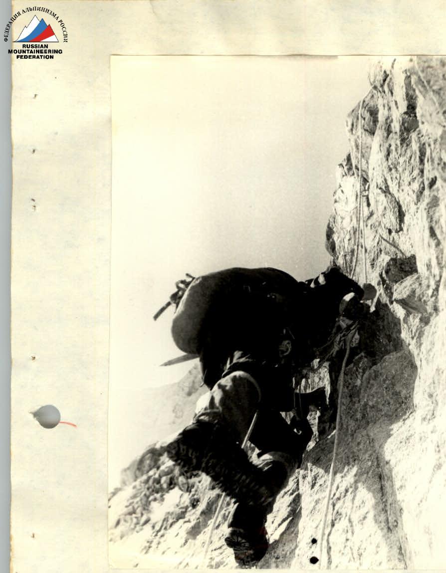
Work of the first rope team. Section R3–R4.
Up the fixed ropes. Section R4–R5

In the lower part of section R13–R14. After the bivouac

Section R15–R16
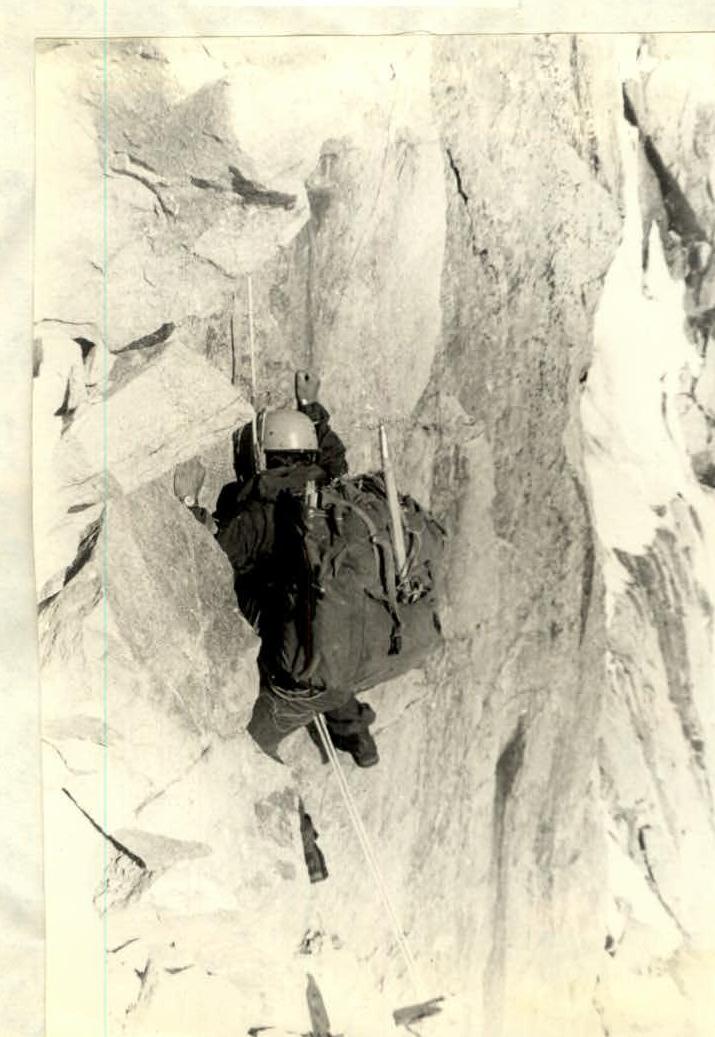
Work of the first on section R16–R17 Soon it's time for the overnight stay. In the upper part of R16–R17


