148
Report
On the first ascent to the summit of Ullarg (4320 m) via the North face, accomplished by the team from the "Tsey" alpine camp
from August 4 to 9, 1968
USSR Alpine Championship 1968. Technical ascents category
Moscow, 1968
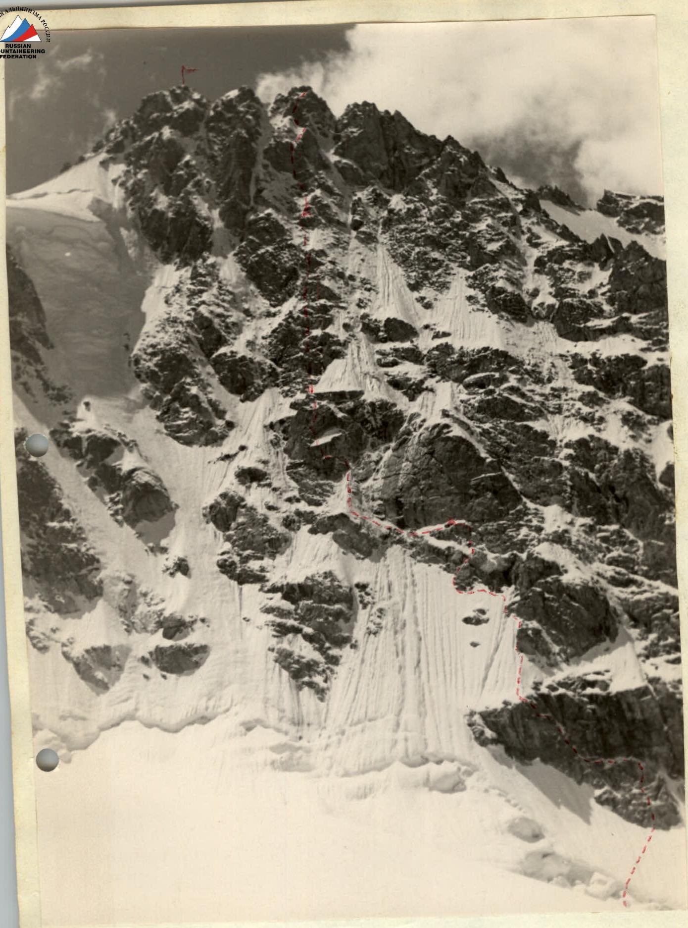
Fig. 1. The North face of Ullarg summit. (Taken from the upper reaches of Songuti glacier on August 5, 1968)
Team Composition
Captain:
YASHNOV Vladimir Ivanovich, born 1934, Russian, member of the CPSU, candidate for Master of Sports of the USSR in alpinism, scientific worker.
Participants:
GORDA Ruslan Aleksandrovich, born 1937, Ukrainian, unranked, 1st sports category in alpinism, scientific worker.
FRIDMAN Alexander Aronovich, born 1937, Jewish, unranked, candidate for Master of Sports of the USSR in alpinism, scientific worker.
RUBLEV Vadim Sergeevich, born 1937, Russian, unranked, 1st sports category in alpinism, postgraduate student.
Section R11–R15
Table
of key characteristics of the ascent route to Ullarg via the North face
Height difference 1000 m, including 350 m of complex sections.
Route steepness 65–70°
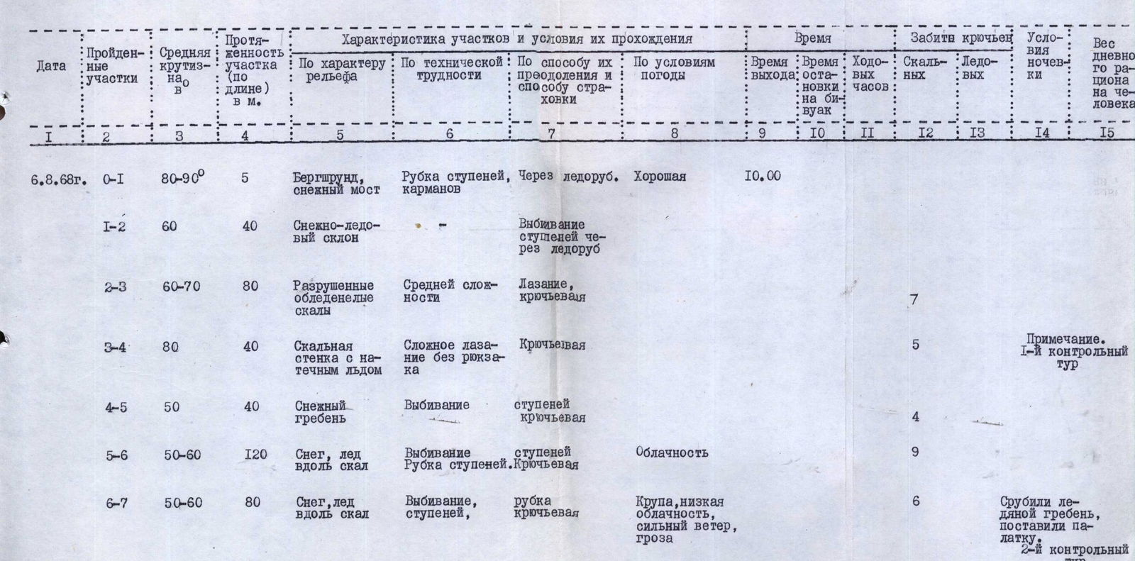
| Date | Sections traversed | Average steepness ° | Section length (by length) in m. | Terrain characteristics | Technical difficulty | Method of overcoming and belaying | Weather conditions | Departure time | Time stopping at bivouac | Hiking hours | Rock pitons | Ice pitons | Camping conditions | Daily ration weight per person |
|---|---|---|---|---|---|---|---|---|---|---|---|---|---|---|
| August 6, 1968 | R0–R1 | 80–90 | 5 | Bergschrund, snow bridge | Cutting steps, pockets | Via ice axe | Good | 10:00 | ||||||
| R1–R2 | 60 | 40 | Snow-ice slope | Kicking steps through ice axe | ||||||||||
| R2–R3 | 60–70 | 80 | Destroyed icy rocks | Medium complexity | Climbing, pitons | 7 | ||||||||
| R3–R4 | 80 | 40 | Rock wall with ice | Complex climbing without backpacks | Pitons | 5 | ||||||||
| R4–R5 | 50 | 40 | Snow ridge | Kicking steps | Pitons | 4 | ||||||||
| R5–R6 | 50–60 | 120 | Snow, ice along rocks | Kicking steps | Cutting steps, pitons | Cloudiness | 9 | |||||||
| R6–R7 | 50–60 | 80 | Snow, ice along rocks | Kicking steps | Cutting pitons | Graupel, low clouds, strong wind, thunderstorm | 6 | Cut ice ridge, set up tent. | 1st control check 2nd control check | |||||
| R7–R8 | 60 | 80 | Snow-covered rocks of medium difficulty | Medium complexity | Climbing, pitons | 17:00 | 7 | 4 | 600 gr. | |||||
| August 7, 1968 | R8–R9 | 70° | 80 | Snow along rocks, crossing ice couloir | Cutting steps, first on crampons, pitons | Good | 6:00 | 3 | 1 | |||||
| R9–R10 | 60 | 80 | Ice ridge | Cutting steps on crampons, pitons | 1 | 3 | ||||||||
| R10–R11 | 80 | 40 | Snow-covered, destroyed rocks, ice | Complex climbing | Climbing, pitons | 7 | ||||||||
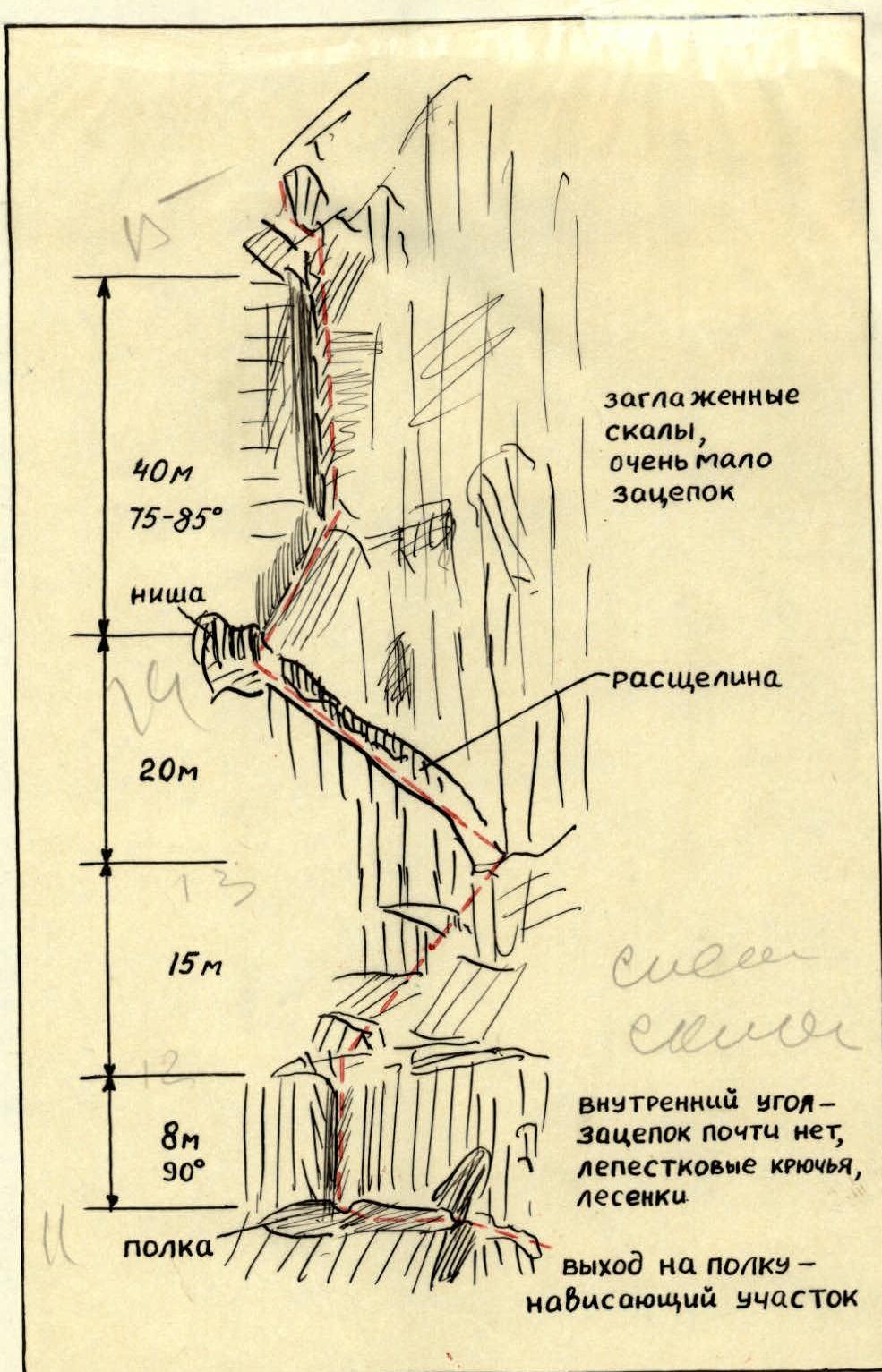
| R11–R12 | 90° | 8 | Inner corner – smooth rocks | Very complex climbing without backpacks using ladders | Pitons | 3 | ||||||||
| R12–R13 | 45 | 15 | Rocks with ice and snow | Medium complexity | Climbing, pitons | 2 | ||||||||
| R13–R14 | – | 20 | Deep crevice | Medium complexity | Climbing through ledge | |||||||||
| R14–R15 | 80–90 | 40 | Inner corner – smooth rocks with ice | Very complex climbing without backpacks | Pitons | 6 | ||||||||
| R15–R16 | 60 | 80 | Snow-covered rocks, little snow on ice | Medium complexity | Climbing, pitons | 2 | 2 | |||||||
| R16–R17 | 80 | 30 | Rock wall | Very difficult climbing without backpacks | Pitons | 6 | ||||||||
| R17–R18 | 60–70 | 80 | Snow-covered destroyed rocks with ice | Medium complexity | Pitons | Low clouds, wind | 9 | 1 | ||||||
| R18–R19 | 80–90 | 40 | Rock wall, many loose rocks | Complex climbing without backpacks | Pitons | Strong wind, graupel | 7 | |||||||
| R19–R20 | 60–70 | 100 | Snow-covered destroyed rocks | Complex climbing | Pitons | Strong wind, thunderstorm | 15:00 | 9 | 6 | 1 | Sitting bivouac. Snow present. | 600 gr. | ||
| August 8, 1968 | R20–R21 | 70 | 120 | Snow-covered rocks, ice | Medium complexity | Climbing, cutting steps on crampons, pitons | Good | 7:00 | 8 | 1 | Note. 3rd control check | |||
| R21–R22 | 90 | 60 | Smooth rock wall with ice | Extremely difficult climbing without backpacks | Climbing with artificial aids, ladders, pitons | 20 | 3 | into rocks, duralumin wedges | Note. Passing the wall took 5 hours | |||||
| R22–R23 | 70 | 120 | Snow-covered destroyed rocks | Medium complexity, last 20 m complex | Climbing, pitons | Cloudiness, wind | 4 | |||||||
| R23–R24 | 80–90 | 20 | Smooth, icy rocks | Very difficult climbing without backpacks | Climbing with artificial aids, pitons | – | 8 | |||||||
| R24–R25 | 70 | 80 | Snow-covered icy rocks | Medium complexity | Climbing, pitons | 18:00 | 11 | 4 | Note. 4th control check on the summit of 2nd gendarme |

From the summit of the 2nd gendarme, a 15 m descent to the southern side, and along ledges, crossing the upper parts of ice and snow couloirs, bypassing the 1st gendarme. Along the rocks of the southern slope, we reach the summit — 1–1.5 hours. Descent from the summit via a 3rd category difficulty route to the saddle towards p. Oniiani — 1.5–2 hours — overnight on the saddle. August 9, 1968 — return to "Tsey" alpine camp.
The team spent 28 hiking hours on the route. To ensure safety, a total of 145 pitons were hammered, including 131 rock pitons (of which 27 were thin petal-shaped), 9 ice pitons, 3 ice pitons in rocks, and 2 thickened wedges. Additionally, 33 rock pitons were used for belays and pulling up backpacks during overnight stays. In total, 178 pitons were hammered.
Section R16–R17
Section R21–R22
Section R22–R23, R23–R24 ,1895,"format":"Jpeg","uri":"https://summitx.info/media/1/pqlKoNkgn8uJtNIZCQBAQRYSuTGPIrkt/img-7.jpeg","id":64755322}↗)
Fig. 4. Crossing the bergschrund at the beginning of the route on the North face of Ullarg (taken on August 6, 1968)
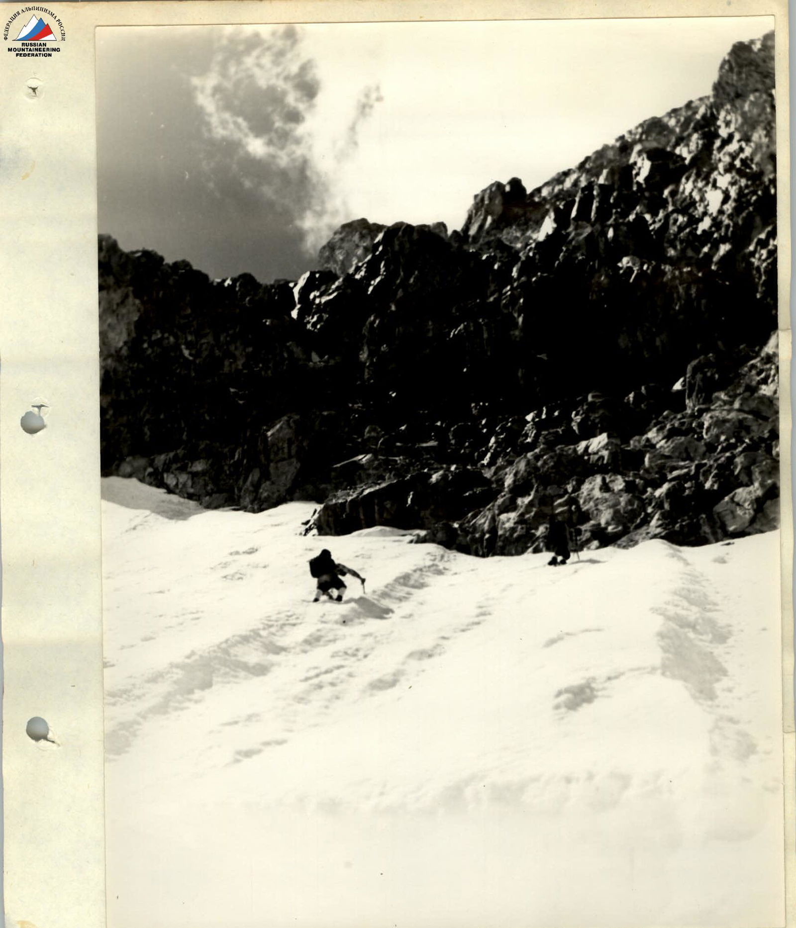
Fig. 5. Snow slope and exit to the first rock massif of the North face of Ullarg (taken on August 6, 1968). The approach route under the North face of Ullarg is described in detail in the section "Brief geographical description...".
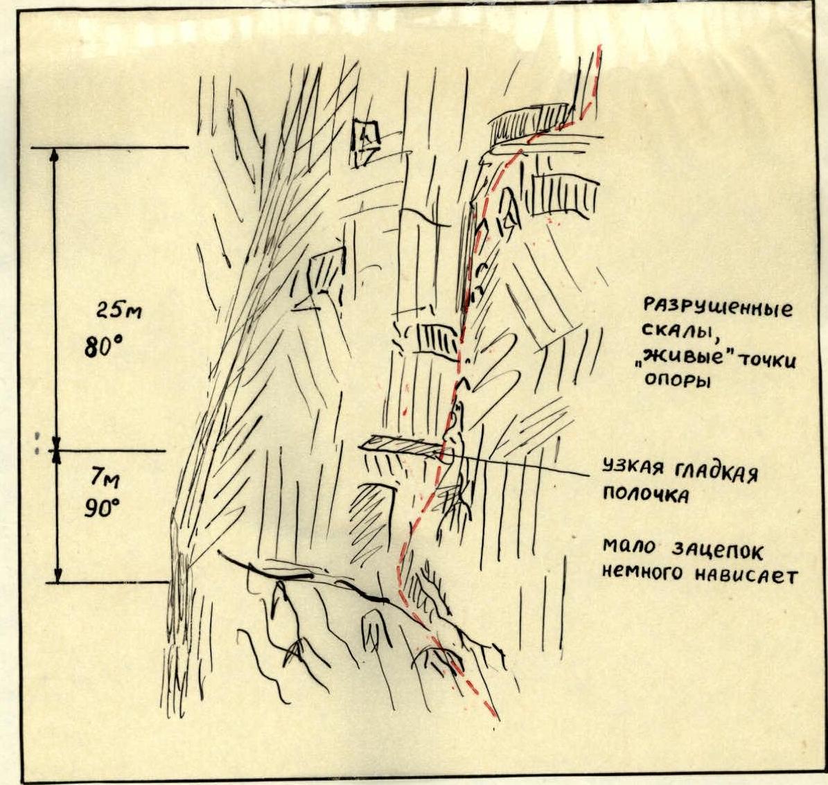
From the plateau, we ascend a snow slope (Fig. 3) with a steepness of 60°–70° to the bergschrund – section R0–R1 in Fig. 6. The bergschrund is overcome via a snow bridge, then along a 3–4 m ice wall using ice axes and ice pitons as points of support and step cutting. From the bergschrund, along a snow-ice slope (R1–R2), we approach the rocks.
The rocks are initially (R2–R3) of medium complexity, then (R3–R4) complex, icy, with many loose rocks. At the top of section R3–R4, there is a platform where the team can gather to pull up backpacks.
The further route logically follows the boundary between snow and rocks upwards to the left, and this relatively less difficult section ends under a triangular convex wall, where a lying bivouac is possible on a snow-ice ledge (R4–R5, R5–R6, R6–R7, R7–R8). The snow ledge abuts an ice couloir, through which stones and icicles continuously fall in the second half of the day. The couloir should be crossed in the morning. However, even at 6–7 am, stones occasionally fell, so the first team member quickly crossed the couloir on crampons and secured the belay rope through an ice piton (R8–R9) on an ice ridge.
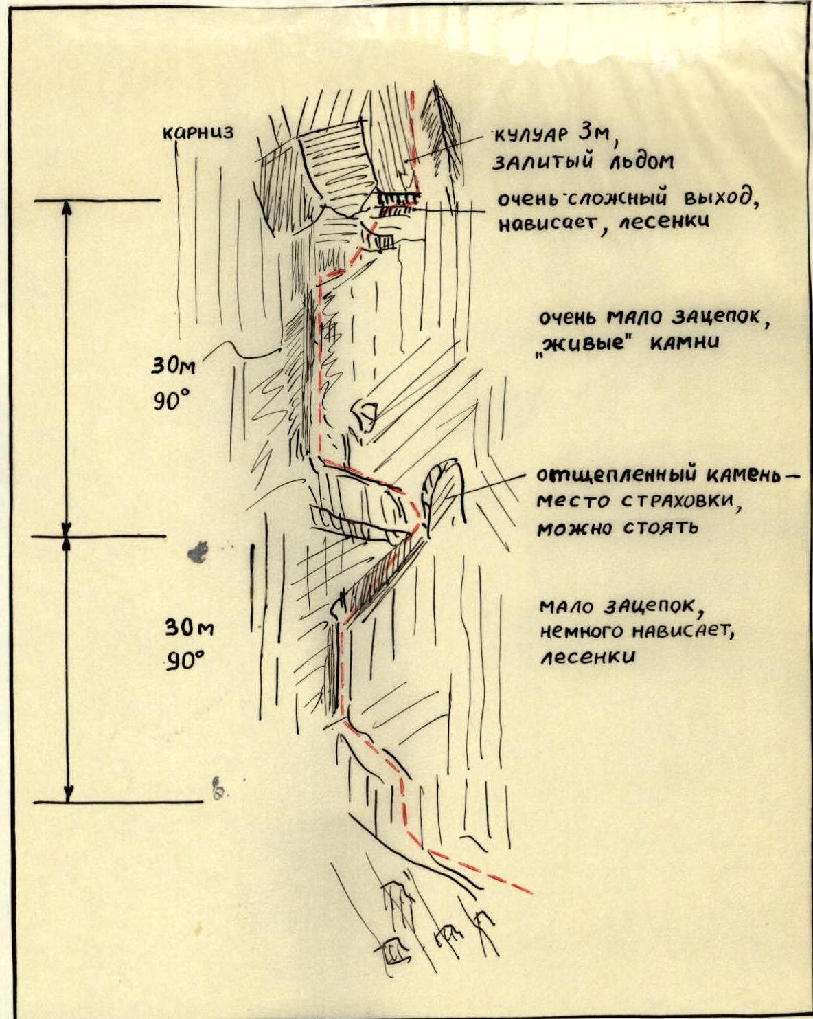
Further, after 120 meters of ice and snow-covered destroyed rocks, the route passes through very smooth slabs in the form of an inner corner (R11–R12), which is traversed using support on a rock piton and ladders. A good landmark and a place where two people with backpacks can fit in a niche formed by split rocks is a long (about 20 m) deep crevice in section R13–R14. From here, a non-obvious inner corner begins directly upwards and to the right with very smoothed, steep ( местами отвесными ) walls.
After pulling up backpacks through the inner corner (with a reepschnur pull from the niche), we traverse 80 m along snow-covered, less complex rocks (R15–R16). From here, the path is only straight upwards along a black
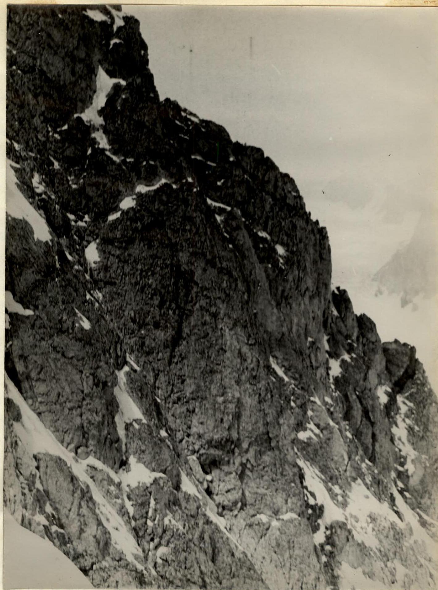
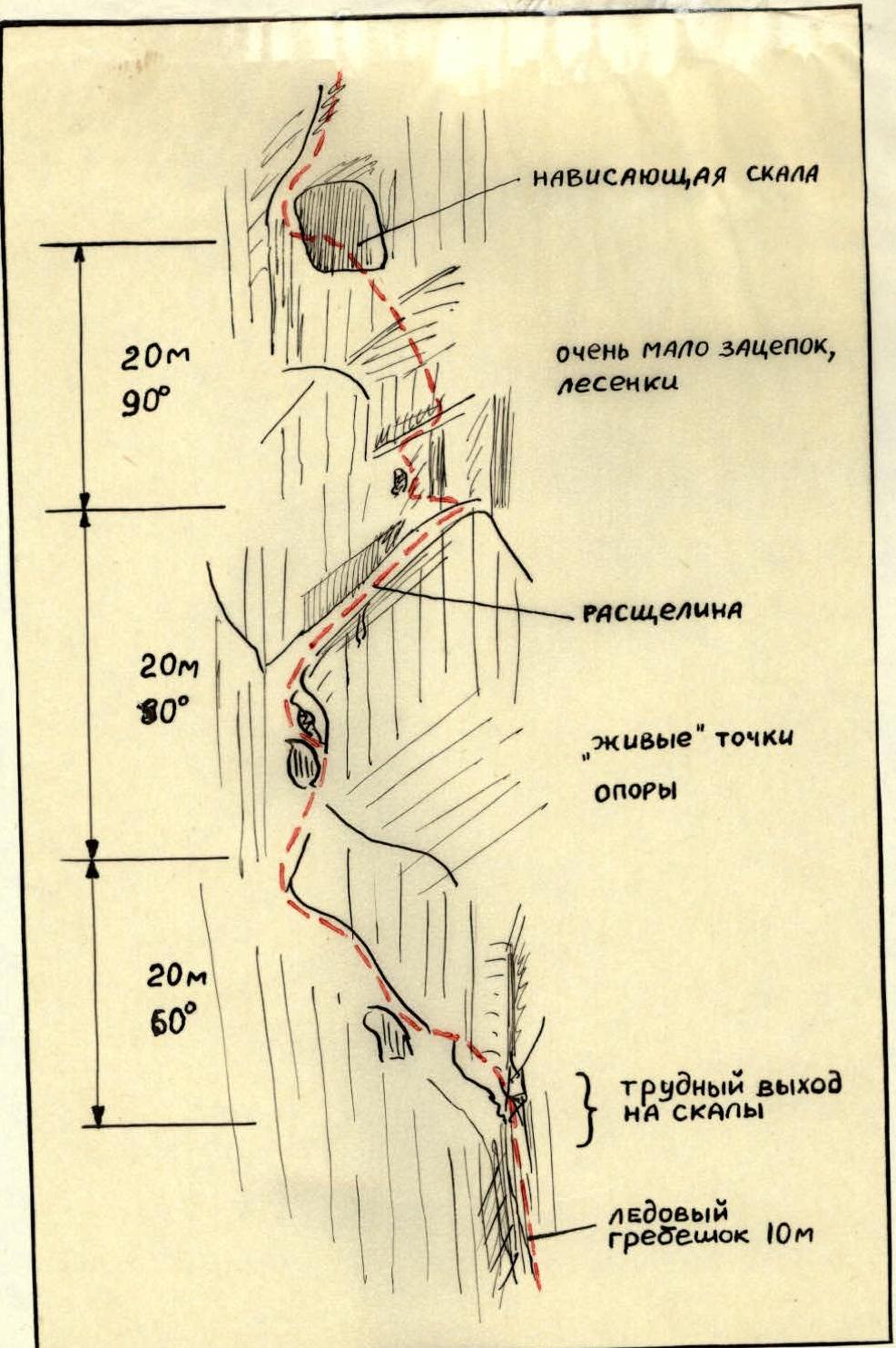
Fig. 7. Profile of the section of the North face of Ullarg after the second overnight stay and the 60-meter wall – sections R20–R21, R21–R22, R22–R23 (taken with a telephoto lens from p. Artsyshevsky on August 9, 1968). 30-meter wall (R16–R17) and further along snow-covered rocks to a 40-meter almost sheer wall, where there are many "live" rocks (R18–R19).
To the left and right of this path, ice and rock "projectiles" are almost continuously whizzing by. On the 40-meter sheer wall, one has to be extremely careful with the rope both during movement and when pulling up backpacks.
During the passage of this wall:
- Graupel fell,
- A very strong wind was blowing.
Having passed another 60 m, we were forced to take cover behind a strong sheer wall (R19–R20), where we waited for a thunderstorm for an hour and a half, and to warm up in the fierce wind, we cut down a large section of the ice slope.
However, it was too early to stop for the night, and the place was not suitable – from above, graupel was falling on our heads and shoulders like a waterfall. Therefore, as soon as the thunderstorm passed, we advanced another 50 m or so. However, neither there nor, as a trial exit showed, further above were there any places suitable for a lying overnight stay.
We spent the second night in a semi-sitting, semi-hanging position, secured on belay ropes and covered with a tent and a "Zdarka". As it later turned out, there was no better safe place for an overnight stay on the remaining section of the wall.
By the morning of August 8, the weather had improved, and having traversed about 120 m along snow-covered rocks and ice (first on crampons), by 9:00 we reached the base of a sheer 60-meter wall (Fig. 7), composed of solid rocks with very few holds and cracks (R21–R22).
To the left and right of the wall, about 40–60 m away, there are very steep ice couloirs, continuously swept by falling rocks.
We prepared expansion bolts, but ultimately didn't use them.
After five hours of very intense work by all team members, the wall was overcome, and backpacks were pulled up.
Finally, the last 20-meter section of very difficult climbing with artificial aids (R23–R24) leads to the pre-summit rocks of the second gendarme (R24–R25).
From the gendarme to the summit of Ullarg – along the rocks of the southern slope – 1 hour 30 minutes.
Thus, the wall is a чередование заглаженных скальных стен крутизной 80–90°, длиной от 8 м до 60 м and less steep (50–70°) more dissected rocks. These sections of snow-covered rocks practically do not have more or less significant ledges suitable for overnight stays.
The constituent rocks are quite strong, местами заглаженные with few holds and cracks. Therefore, thin titanium pitons (like petals) were used especially often, and to a lesser extent:
- thickened titanium wedges,
- aluminum wedges,
- ice pitons in rocks.
With an overall height difference of 1000 m on the wall, 350 m are sections with very difficult climbing without backpacks, using artificial points of support, ladders, and abalaks. On these sections, about half of all pitons were hammered, on average:
- one piton per 5 m.
By the unanimous opinion of the team members, the route along the North face of Ullarg is significantly more complex technically than all routes of 5B category difficulty completed by the team members, including those in the Tsey region:
- p. Passionarii
- Mamisong-Hokh.
The route planned in advance was fully adhered to by the team and is, apparently, the most logical and objectively safest. The high rockfall danger of the couloir in section R8–R9 in the second half of the day confirmed the correctness of the tactical plan for the ascent (overnight stay in section R7–R8) and an early departure from this bivouac.
The auxiliary observation group consisted of two climbers with 2nd sports category – Markovsky M. and Vitsenko V., who had sufficient training by the time of the ascent.
M. Markovsky, a radio engineer by profession, set up radio communication with the alpine camp perfectly.
On August 8, 1968, at 10:00, when the team was passing the 60-meter wall in the upper part of the route, the observers left their bivouac under the Ullarg wall for the saddle between p. Oniiani and p. Artsyshevsky.
Visual contact between the team and the observers was maintained until 14:00 on August 8, when the team had passed the most complex section – R21–R22, and there were only 2 ropes of simpler rocks left to reach the summit of the gendarme.
Thus, we believe that the observers fully performed their task.
Overall assessment of the actions of team members
All team members during the ascent demonstrated:
- excellent physical fitness
- technical preparedness
- sufficient tactical maturity.
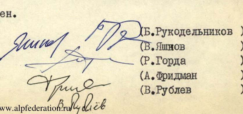
Team coach — (MS USSR B. Rukodelnikov)
Team captain — (CMS USSR V. Yashnov)
This report on the ascent was discussed by all team members and unanimously approved.