REPORT
on the ascent to Mt. Ullarg via the Northwest Buttress by a group of climbers
MOS DSO "Trud"
§ 1. Geographical description of the area and sporting characteristics of the region
The summit of Ullarg (4320 m) is located in a lateral spur of the main Caucasian ridge, beyond the peaks of Uilpata and Songuti-khokh. The peaks of Arcihevskogo and Oni-Ani follow after Ullarg. The Ullarg region is still poorly explored from the north. It is far from active camps, and there are no convenient approaches. The only relatively easy access is from the northeast, from the villages of Dunta and Komunta, along the Songuti-don river. The path from the villages of Dunta and Komunta is long and difficult to traverse.
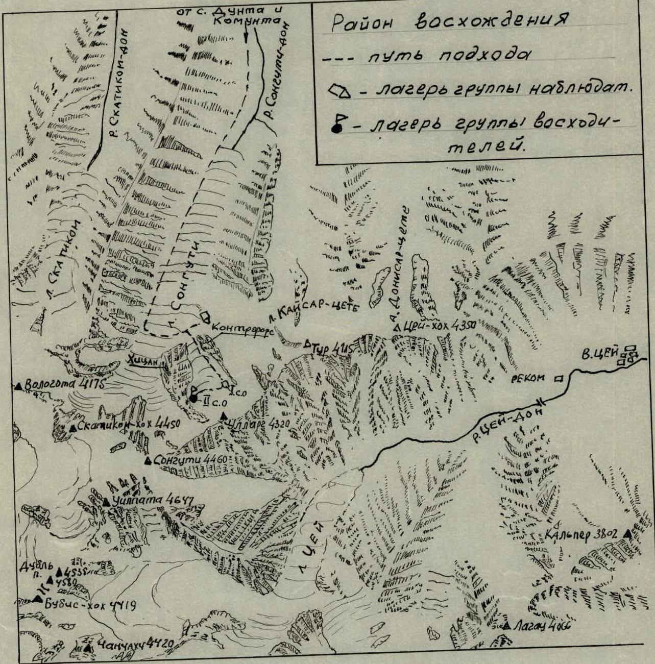

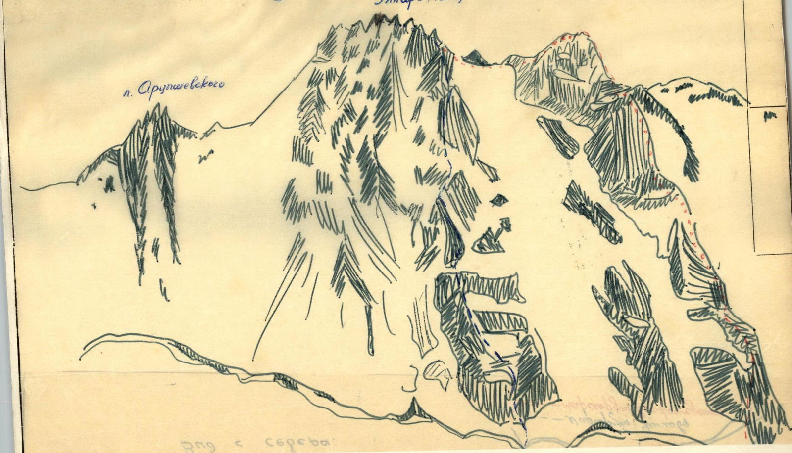
To date, only one route to the summit of Ullarg from the north was laid by Yashnov's group in 1968. This route is classified as category 5B and passes through the right part of the northern wall. The central part of the wall and the very beautiful and interesting path along the northwest buttress remain unclimbed.
The nearest peak to the east of Ullarg is Pik Arcihevskogo; it is lower than Ullarg, and the routes to it are shorter. However, its northern walls are steep, and bivouac sites are not visible. To the right of Ullarg (to the west) are the northeastern walls of the peaks Sanguti-khokh (4460 m) and Skatikom-khokh (4450 m). On Mt. Skatikom-khokh, there is a route classified as category 5B. To the right, in the distance, the black wall of Vologota (4175 m) is visible.
Northwest Buttress
July 26
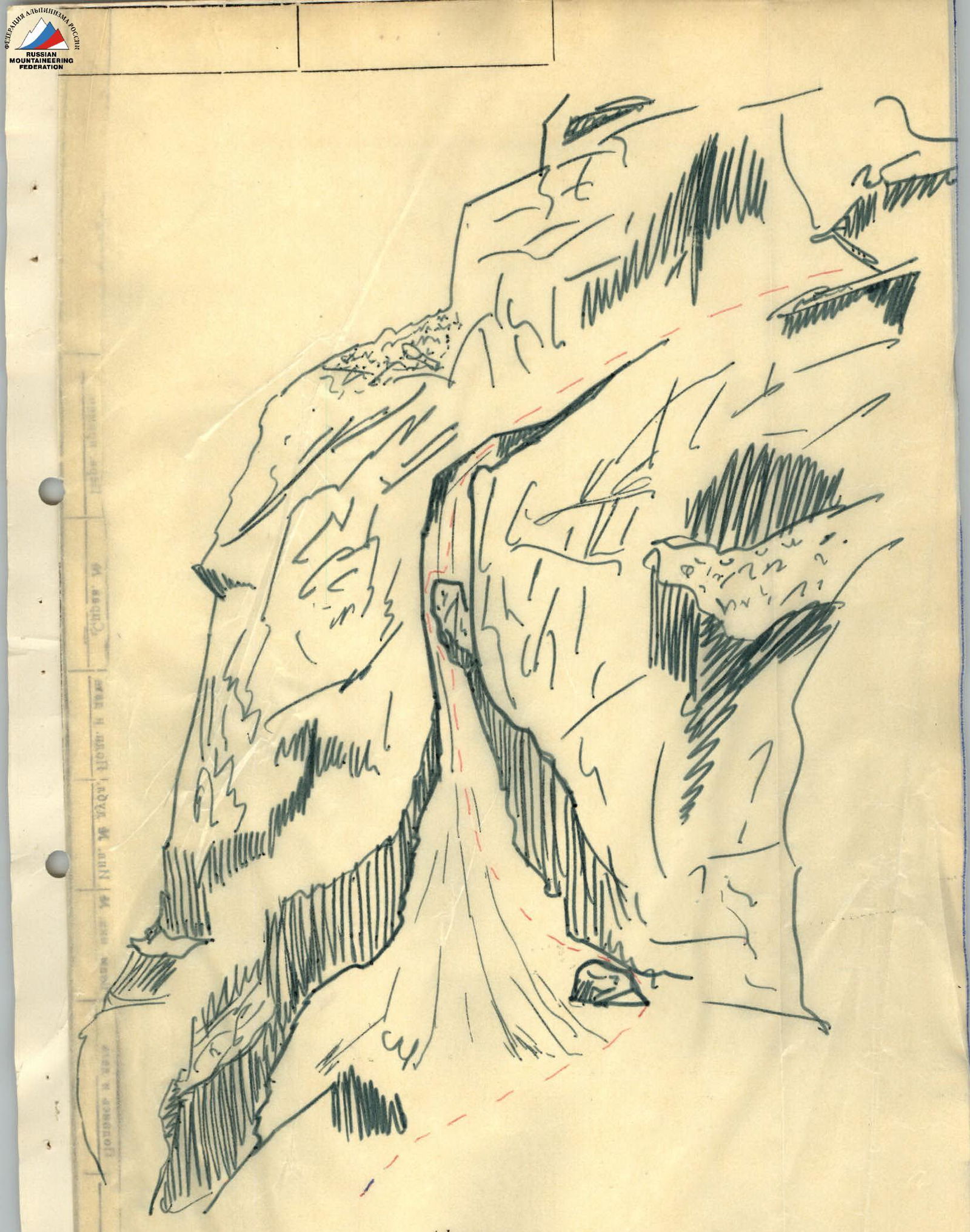
Departure at 6:00 AM from the overnight stay at the rocky island and approach to the start of the route. After putting on crampons and linking up (Reformatsky - Kravchenko - Merlis; Cemko - Nim), they began the ascent to the bergschrund (R0-R1). After crossing the bergschrund, they ascended a steep snow-ice slope to icy rocks. The slope's steepness is 60°, and its length is 80 m. Here, ice screws were used (R1-R2). The exit is onto slab-type rocks. Movement is along smooth rocks with few holds; insurance is via pitons (combined pitons) (R2-R3). Next follows a 10 m section with a steepness of 80-85°, traversed by complex climbing (R3-R4). The rocks are of medium difficulty; movement is simultaneous (rockfall hazard) (R4-R5). A traverse from the left side along ledges bypasses the red gendarme. To the right is a snow-ice couloir. On the ledge, the first cairn is built (R5-R6). The path goes along icy ledges to the right part of the buttress under the cliffs above the drops (R6-R7). Further movement is along steep rocks with a steepness of 70° and a length of 40 m. For insurance, ice and rock pitons are used. Traverse to the right side. Approach to a narrow couloir (R7-R8). Passage through the narrow couloir. Water is flowing. The couloir is 80 m long and has a steepness of 80°. The couloir is filled with ice. Its walls are sheer, and exiting onto clean rocks is impossible. Complex climbing. The couloir is narrow; its width at the base is 10 m and narrows to 2-3 m further up. At 60 m into the couloir, there is a rock overhang; under the overhang is a good spot for insurance, protected from rocks and ice fragments. Exit from under the overhang is on the left side. Beyond the overhang, there are 20 m of complex climbing. From 11:00 AM, the couloir becomes rockfall-hazardous.
Throughout the day, the lighting on the couloir walls changes. The first to traverse the couloir took 2 hours. The entire group overcame the couloir in 4 hours (R8-R9). In the upper part of the couloir, there is an exit onto its right wall (45°, 40 m), and from it onto a talus ledge (R9-R10).
Movement to the right along a snowy, sloping talus ledge, 40 m long. Movement is simultaneous (R10-R11).
From the ledge, the path goes along a complex rock wall (75-80°). Complex climbing with few holds. The length of this section is 60 m. In the middle part of the wall, there is an exit onto a narrow ledge. The first climber left their backpack; all others had their backpacks pulled up (R11-R12).
Further movement:
- initially along the right side of the rocks,
- then to the left,
- along the boundary of ice and rocks to a sloping rock ledge that crosses the entire buttress along its perimeter.
Overnight stay. Water is available. Arrival at the bivouac at 19:00. A platform for the overnight stay was built from rocks. Horizontal handrails were hung for movement along the ledge. Throughout the entire day, as in the following days, the weather was clear.
July 27
Departure at 6:00 AM. Beginning of movement at 7:00 AM. A cairn was built at the bivouac (R12-R13). Movement along rocks of medium difficulty, with a steepness of 45-50°. Movement is simultaneous. The length of the section is 40 m. Exit onto a ledge where an overnight stay is possible (R13-R14). Exit along a sloping ledge, 40 m long, to a couloir filled with ice. (R14-R15). Passage through the couloir, 80 m long and 80° steep (on the left side along the route), along the boundary of ice and rocks. Complex climbing with the use of piton insurance and step-cutting. In the middle of the couloir, there is an overhang. Complex climbing. Pitons are driven into the left rock wall of the couloir (R15-R16). Exit onto a flattening part of the buttress over a 120 m section. Further down is a depression in the ridge. A good spot for an overnight stay. The third cairn is built. Time: 10:30 AM (R16-R17). After the depression, movement is along a steep ridge with a steepness of 80° and a length of 40 m. The rocks are solid, with few holds. Complex climbing (R17-R18). Backpacks are pulled up. The passage of this section is completed at 13:00 (R18-R19). Movement along the ridge. Semi-destroyed rocks of reddish color. After 200 m, an approach to the first gendarme (R19-R20). Passage of the gendarme "head-on" with piton insurance (R20-R21). Sporty descent from the first gendarme into a dip and approach to the second gendarme (R21-R22). Ascent onto the second gendarme (50°, 60 m) (R22-R23). Descent from the second gendarme via rappel. 15 m. To a snowy saddle. Exit onto the saddle at 16:00. A platform was made in the snow, and horizontal handrails were hung. Overnight stay.
July 28
Departure at 6:25 AM. (R23-R24). Passage along the saddle, 40 m long, on a sharp snowy ridge. Movement is alternating. Insurance is via ice axe. (R24-R25). Exit onto the ridge along destroyed rocks of medium difficulty. Passage along a ridge of the "saw" type. Movement is simultaneous.
To the pre-summit tower. Here, the path coincides with the route taken by Yashnov's group in 1968 along the northern wall. The length of the section is 360 m (R25-R26). Exit onto the pre-summit tower along cleaved slabs with good holds (85°, 40 m). Tense climbing (R26-R27). Exit along the ridge (30°, 60 m) to the summit (11:07). Rest on the summit: 30 minutes. The weather is sunny. Descent from the summit via the route at 30 km/h through Pik Arcihevskogo to Volginskie bivouacs. The group descended to the alpine camp Tsey at 21:00.

Ullarg (4320 m)
Section 7-8 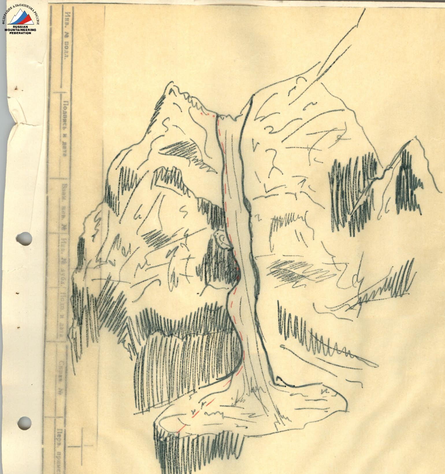
Section 14-15