Ascent Passport
- Ascent class — technical.
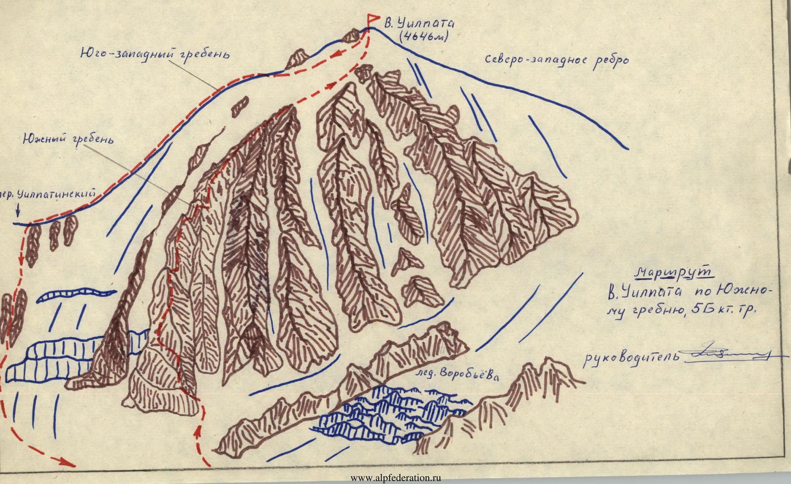
- Ascent area, ridge — CAUCASUS, Tsey ridge.
- Peak UILPATA, 4646 m, via the South ridge.
- Difficulty category — 5B.
- Length — 1409 m. — sections of 3rd diff. cat. — 792 m, — sections of 4th diff. cat. — 205 m, — sections of 5th diff. cat. — 83 m.
- Number of pitons driven — 78 pcs.
- Travel time — 23 h.
- Number of overnight stays — 1 (in the area of the second control stage).
- Team composition: — Oleg Filippovich Filyakin, born 1949 — 1st sports category, leader; — Tatyana Mikhailovna Prilepina, born 1946 — Candidate for Master of Sports, participant; — Gennadiy Aleksandrovich Musin, born 1952 — 1st sports category, participant; — Aleksandr Sergeyevich Popov, born 1947 — 1st sports category, participant.
- Team coach: Master of Sports in mountaineering Z.F. ZAYEV.
- Entry into the route — July 22, 1984.
Return — July 23, 1984, to Tsey overnight stays and July 24, 1984, to "TORPEDO" alpine camp.

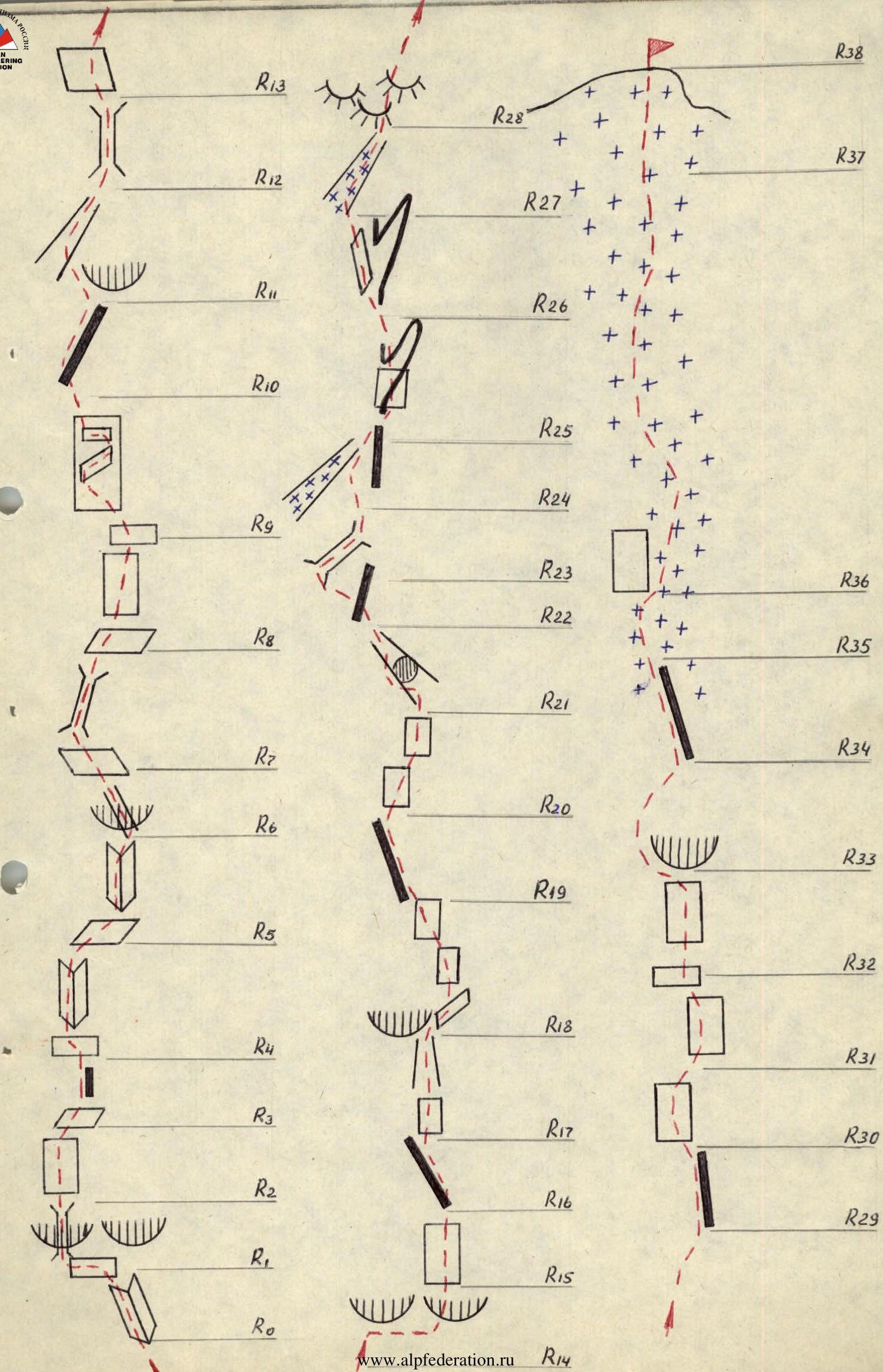 Table 2

| Date | Ref. | Avg. slope in degrees | Length in meters | Terrain character | Diff. cat. | Condition | Weather conditions | Rock | Ice | Used |
|---|---|---|---|---|---|---|---|---|---|---|
| July 22, 1984 | R0–R1 | 65° | 13 | inner angle + ledges | 4 | monolith | clear | 2 + 3Б | — | — |
| R1–R2 | 90° | 8–10 | crevice | 5 | monolith | clear | 5 | — | — | |
| R2–R3 | 70° | 10 | wall | 4 | monolith | clear | 3 + 2Б | — | — | |
| R3–R4 | 55–60° | 15 | inner angle | 3 | monolith | clear | 1 + Б | — | — | |
| R4–R5 | 55–58° | 15 | inner angle | 4 | monolith | clear | 4 + 1Б | — | — | |
| R5–R6 | 65–70° | 6 | ledge, inner angle | 4 | monolith | clear | 2 | — | — | |
| R6–R7 | 85–95° | 7–8 | cornice, crack | 5 | monolith | clear | 4 + 2 | — | — | |
| R7–R8 | 65–70° | 25 | gully | 4 | broken rock | cloudy | 4 | — | — | |
| R8–R9 | 45–47° | 15 | wall | 3 | monolith | cloudy | 1 + 3Б | — | — | |
| R9–R10 | 55–60° | 100 | wall | 3–4 | monolith | cloudy | 13 + 2Б | — | — | |
| R10–R11 | 30–35° | 80 | ridge | 2 | broken rock | cloudy | alternately | — | — | |
| R11–R12 | 45–50° | 30 | steep gully | 3 | broken rock | overcast, cloudy | alternately | — | — | |
| R12–R13 | 80–95° | 8 | chimney with overhang | 4 | monolith | overcast, cloudy | 3 + 1Б | — | — | |
| July 23, 1984 | R13–R14 | 50° | 15 | inclined slab | 2 | monolith | overcast, cloudy | 2 | — | — |
| R14–R15 | 95° | 3–4 | cornice | 5 | monolith | overcast, cloudy | 4 | — | — |

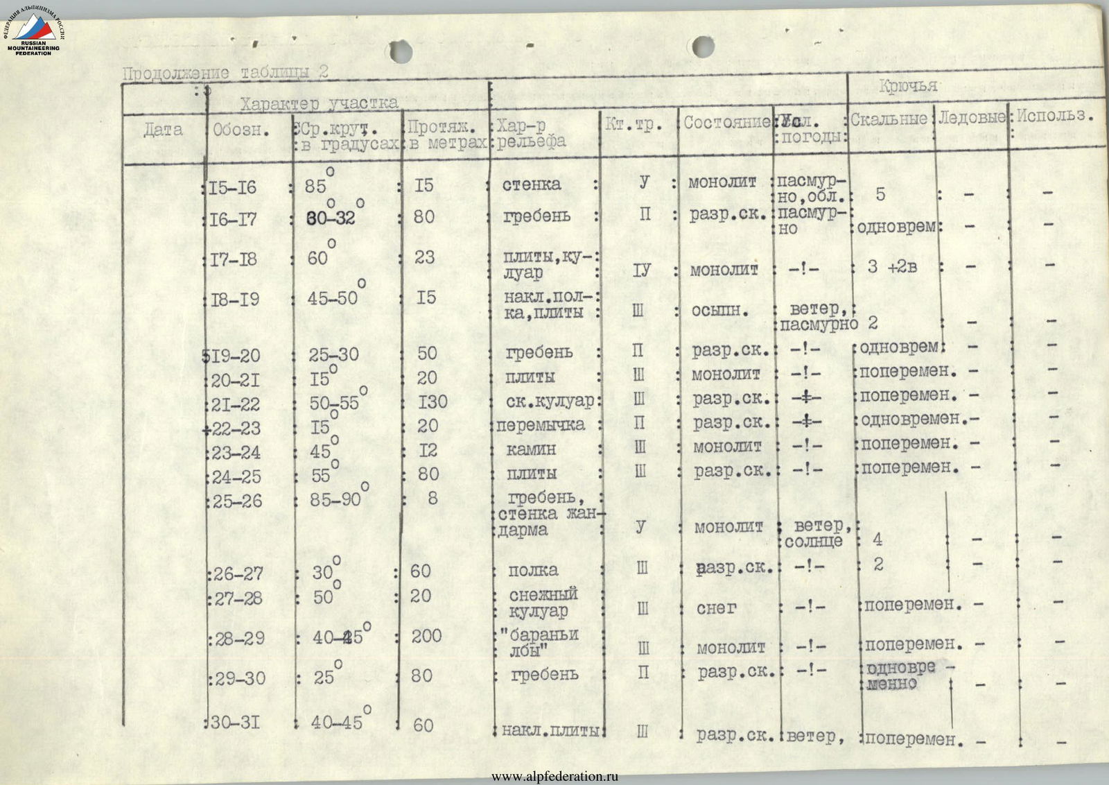
Continuation of Table 2
| Date | Ref. | Avg. slope in degrees | Length in meters | Terrain character | Diff. cat. | Condition | Weather conditions | Rock | Ice | Used |
|---|---|---|---|---|---|---|---|---|---|---|
| R15–R16 | 85° | 15 | wall | 5 | monolith | overcast, cloudy | 5 | — | — | |
| R16–R17 | 80–82° | 80 | ridge | 2 | broken rock | overcast | simultaneously | — | — | |
| R17–R18 | 60° | 23 | slabs, gully | 4 | monolith | — | 3 + 2Б | — | — | |
| R18–R19 | 45–50° | 15 | inclined ledge, slabs | 2 | scree | wind, overcast | 2 | — | — | |
| R19–R20 | 25–30° | 50 | ridge | 2 | broken rock | — | simultaneously | — | — | |
| R20–R21 | 15° | 20 | slabs | 2 | monolith | — | alternately | — | — | |
| R21–R22 | 50–55° | 30 | rocky gully | 2 | broken rock | — | alternately | — | — | |
| R22–R23 | 15° | 20 | saddle | 2 | broken rock | — | simultaneously | — | — | |
| R23–R24 | 45° | 12 | chimney | 3 | monolith | — | alternately | — | — | |
| R24–R25 | 55° | 80 | slabs | 3 | broken rock | — | alternately | — | — | |
| R25–R26 | 85–90° | 8 | ridge, wall of a pinnacle | 5 | monolith | wind, sun | 4 | — | — | |
| R26–R27 | 30° | 60 | ledge | 3 | broken rock | — | 2 | — | — | |
| R27–R28 | 50° | 20 | snowy gully | 3 | snow | — | alternately | — | — | |
| R28–R29 | 40–45° | 200 | "ram's foreheads" | 3 | monolith | — | alternately | — | — | |
| R29–R30 | 25° | 80 | ridge | 2 | broken rock | — | simultaneously | — | — | |
| R30–R31 | 40–45° | 60 | inclined slabs | 3 | broken rock | wind | alternately | — | — |
Continuation of Table 2
| Date | Ref. | Avg. slope in degrees | Length in meters | Terrain character | Diff. cat. | Condition | Weather conditions | Rock | Ice | Used |
|---|---|---|---|---|---|---|---|---|---|---|
| R31–R32 | 80° | 30 | wall | 4 | broken rock | wind, cloudy | 5 | — | — | |
| R32–R33 | 85–90° | 40 | wall | 5 | monolith | wind, sun | 8 | — | — | |
| R33–R34 | 30–35° | 100 | snowy rocky ridge | 3 | snowy rock | — | alternately | — | — | |
| R34–R35 | 30–35° | 160 | rocks | 2 | broken rock | wind, cloudy | simultaneously | — | — | |
| R35–R36 | 40–45° | 50 | snowy rocky slope | 2 | snow | — | simultaneously | — | — | |
| R36–R37 | 45–50° | 370 | snowy slope | 2 | snow | — | simultaneously | — | — | |
| R37–R38 | 55–60° | 40 | ice-snow slope | 3 | firn | — | alternately | — | — |
Brief description of the approach
From the "TORPEDO" alpine camp, an asphalt road leads up to the "TSEY" tourist base. Then the trail enters the forest zone and ascends to the Tsey Glacier along the territory of the reserve (1 h). Exiting the forest zone to the glacier tongue, the trail turns right upwards under the slopes (Tsey horseshoe). Along the slope, crossing several lateral tributaries on the right, the trail leads to the Tsey overnight stays (2 h from "Torpedo" a/c). From the overnight stays, the trail first follows the moraine ridge, then along the slope approaches the "ram's foreheads" located to the right of the icefall (1st stage of the Tsey Glacier).
Climbing up the "ram's foreheads", which are snow-covered in the upper part, to the first stage of the glacier. Avoiding crevices, the trail leads to the middle part of the glacier (here the glacier is open).
Following the stream running along the center of the glacier, ascend to the confluence of the Southern and Northern branches of the Tsey Glacier and further, staying close to its right side (dangerous due to crevices), under the slopes of Peak Khitsan, where the Nikolaevskaya hut is located (2 h from Tsey overnight stays).
From the hut, ascend right upwards to the Khitsan Pass (1 h). Descending from the pass (dangerous due to crevices), the trail crosses the glacier in the direction of a scree moraine under the opposite slopes (Uilpatinskye overnight stays).
From the Uilpatinskye overnight stays, in the direction of Peak Uilpata, bypassing the rocky "fence" on the left, approach the left counterfort of the peak (1 h).
From "Torpedo" alpine camp — 6–8 h.