UKRAINIAN REPUBLICAN COUNCIL OF THE STUDENT SPORTS SOCIETY "BUREVESTNIK"
FIRST ASCENT TO THE SUMMIT OF UILPATA-TAU VIA THE CENTRAL RIB FROM THE EAST, 5B category of difficulty (report) Caucasus, Tsey, July 26–28, 1968
I. Introduction
1. Brief characteristics of the ascent area
The summit of Uilpata-tau (4646 m) is located in close proximity to the Main Caucasian Range and towers above all other peaks in the Tsey region of the Caucasus.
The Tsey mountain region is situated to the northeast of the Main Caucasian Range, encompassing peaks from Nokauk-sakh-zayne in the west to Mamison-Khokh in the east.
The main peaks of the region — Fday-khokh, Zomag-taU, Ronketti, Mamison-Khokh, ChanchaKhi-Khokh, Uilpata-tau — are arranged in two "horseshoes" that divide the Tsey Glacier into two cirques: the South and North cirques.
In the North cirque of the Tsey Glacier are located the peaks:
- Mamison-Khokh to the west,
- ChanchaKhi-Khokh to the north,
- Dubl-peak,
- with the cirque being closed by the summit of Uilpata-tau to the east.
2. Sporting characteristics of the summit Uilpata-tau
The summit of Uilpata-tau is the highest peak in the Tsey region, and this fact, considering the climatic conditions of the area, imposes certain requirements on the physical and technical preparation of climbers.
There are several popular routes to the summit of Uilpata-tau. From the north, a route of 5A category of difficulty passes.
To the east, towards the North cirque of the Tsey Glacier, Uilpata-tau drops with three distinct ribs separated by narrow, rockfall-prone couloirs. To the left, on the border with the peak Krasnoflotets, to the right of the icefall, a route of 2B category of difficulty passes, which serves as the descent route when ascending Uilpata-tau.
The right rib, traversed by a group led by G.V. Polevoy, represents a route of 5A category of difficulty. The Central rib, being the most complex and lengthy, naturally drew interest and became the objective of our ascent.
II. Composition of the assault group
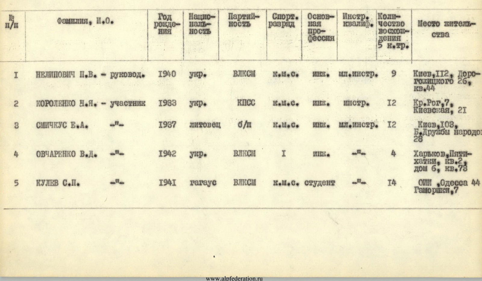
| № | Surname, Initials | Year of birth | Nationality | Party affiliation | Sports rank | Main profession | Instr. qualification | Number of ascents of 5th category of difficulty | Place of residence |
|---|---|---|---|---|---|---|---|---|---|
| 1 | Nelipovich P.V. - leader | 1940 | Ukrainian | VLKSM | CMS | Engineer | Junior instructor | 9 | Kiev, 112, Dorogolitskogo, 26, apt. 44 |
| 2 | Korolenko N.Ya. - participant | 1933 | Ukrainian | CPSU | CMS | Engineer | Instructor | 12 | Kr. Rog, 7, Kievskaya, 21 |
| 3 | Smickus E.A. | 1937 | Lithuanian | Non-party | CMS | Engineer | Junior instructor | 12 | Kiev, 103, B. Druzhby Narodov, 28 |
| 4 | Ovcharenko V.D. | 1942 | Ukrainian | VLKSM | 1st sports rank | Engineer | — | 4 | Kharkov, Pyatikhatki, bldg. 2, apt. 73 |
| 5 | Kulev S.P. | 1941 | Gagauz | VLKSM | CMS | Student | — | 14 | OII, Odessa 44, Gamorishki, 7 |
VI. Description of the ascent
From the overnight camp, the path leads towards the junction of two snow aprons into a single avalanche slope. The steepness of the avalanche slope is approximately 25–30°. The route begins in the middle of this slope.
The route starts from left to right along an oblique steep ledge. The roped teams link up at the beginning of the rock section. The ledge, 100–120 m long, consists of slab-like walls, occasionally interspersed with less steep smooth sections. The average steepness of the oblique ledge is 60–70°.
The ledge ends with a 2–3 m vertical wall, which is overcome directly. The protection is hook belay. A distinctive feature of this section is the shingle-like structure of the rocks, with completely smooth surfaces and very narrow cracks. To ensure safety, as well as to create artificial handholds, it is necessary to use pitons.
At the end of the ledge, on a distinct shoulder, is the I control cairn. Climbing is difficult throughout. The protection is hook belay.
After the I control cairn, the route passes along a degraded ledge, at the beginning of which there is snow (15 m), and then we approach a wall. About 80 m is traversed along the ledge. The wall is initially climbed directly upwards (6–8 m), then traversed to the right and upwards to exit onto a counterfort leading towards the ridge (25–30 m). The protection is hook belay. Climbing is complex, requiring the use of artificial aids — ladders. The counterfort transitions into a vertical wall (10–15 m), which is bypassed via steep slabs to the right and then along degraded slabs at 60° to a wall near the ridge (40 m). We exit onto the ridge via a 3–4 m vertical corner (Zaltsug). We emerge onto a large slab. Here is the II control cairn.
From the II control cairn, a 40 m wall is climbed using complex climbing techniques. The wall has negative sections. The first climber ascends without a backpack. It is necessary to use artificial aids, ladders, pitons with carabiners, and hand loops. All backpacks are pulled up to the overhanging section, a distance of 20 m. The protection is hook belay. For safety, it is advisable to use drilled pitons.
Further on, the route exits onto the ridge via a steep 70–75° ledge, 10 m long. Climbing is complex and exposed. The beginning of the ridge is very challenging. It is climbed at the top until an acute rock outcrop is reached, which is overcome by hanging and stepping over to the right, towards a negative corner where there is a good foothold. Then, 20 m further to the rise of the ridge, there is a good platform for an overnight bivouac. Here is the III control cairn (hanging on a piton). Overnight stay. From the start of the route, 14–16 ropes of 40 m each have been used.
From the overnight bivouac (III control cairn), the path goes along a wall to the left of the ridge, 30 m. Climbing is complex, and at the beginning, an artificial aid (piton) is used.
Further along the ridge, we approach a high gendarme with vertically sheer walls. The gendarme is bypassed along a steep, not clearly defined ledge to the right, obliquely downwards in the direction of travel. The total length of the descending ledge is approximately 120 m. To the right, a stream flows down the wall.
We approach a wall. The path goes to the left of the stream, 20 m. Climbing is difficult. Artificial aids are used.
Further on, the path leads to degraded rocks of moderate difficulty in the direction of a couloir filled with snow, descending from the ridge above the "gendarme" (180 m). The couloir is safe.
To the right of the couloir is a wall, over which water flows in a wide front. It is climbed directly. Climbing is complex. The protection is hook belay. Then, we exit onto a ledge with a large number of loose rocks. To avoid dislodging rocks, movement is made towards the ridge (obliquely) with alternating belay via outcrops.
Having reached the ridge, we continue moving until a 3-meter rise is encountered, and then along the left side of a snowy couloir (60 m), after which we exit onto rocks of moderate difficulty. The ridge leads to the beginning of the pre-summit snowy ridge. Here is a platform for an overnight bivouac.
Further on, the path follows along a snowy slope to the summit. The descent is made via the route of 2B category of difficulty.

VIII. Conclusion
The route to the summit of Uilpata-tau, 4646 m, from the east via the Central rib can be classified as a combined route. This route is exceptionally logical and objectively safe, featuring diverse forms of mountain relief.
A distinctive feature of this route in the Tsey region of the Caucasus is its relatively great length, as well as the fact that its first half (15 ropes of 40 m each) presents the main technical difficulty.
To traverse the route, it is necessary to have a diverse set of rock pitons. The mandatory presence of petal pitons, as well as duralumin or titanium wedges, is required.
The group used:
- 78 rock pitons
- 4 ice pitons
- 12 wedges
To complete the route, 26 hours of climbing time were required.
The successful and swift traversal of the route was facilitated by good weather conditions throughout the ascent.
The optimal number of participants in the group is 4–6 people, as some sections of the route are best traversed without backpacks, with their subsequent hauling.
Main characteristics of the route:
- First ascent to the summit of Uilpata-tau from the east via the Central rib.
- Height difference — 1000 m, including the most complex sections — 400 m.
- Steepness of the route (average) — 50°, including the most complex sections — 70–80°.
| Date | Sections traversed | Average steepness | Length of section | Characteristics of sections and conditions of passage | Exit to bivouac | Stop at bivouac | Climbing time | Pitons (steel) | Pitons ( feathered) | Pitons (wedges) | Pitons (drilled) | Bivouac conditions | Notes |
|---|---|---|---|---|---|---|---|---|---|---|---|---|---|
| 1 | R1 | 60° | 40 m | ledge, difficult, hook belay, clear | 3:00 | 4 | 0 | 1 | |||||
| 2 | R2 | ~70° | 40 m | wall, very difficult | 6 | 0 | 1 | ||||||
| 3 | R3 | 60° | 40 m | wall, difficult | 6 | 0 | 2 | ||||||
| 4 | R4 | 40° | 80 m | degraded ledge, moderate difficulty, alternating, outcrops (I control cairn) | 2 | 0 | 0 | ||||||
| 5 | R5 | ✓ 70° | 30 m | wall, very difficult, ladders, hook belay | 8 | 0 | 1 | ||||||
| 6 | R6 | ✓ 50° | 40 m | slabs, moderate difficulty | 4 | 0 | 0 | ||||||
| 7 | R7 | 80° | 20 m | wall, very difficult | 5 | 0 | 0 | ||||||
| 8 | R8 | ✓ 50° | 120 m | slabs, moderate difficulty, alternating, hook belay | 6 | 1 | 2 | ||||||
| 9 | R9 | 80° | 10 m | wall, very difficult, hook belay, Zaltsug (II control cairn) | 2 | 0 | 1 | ||||||
| 10 | R10 | 80° | 40 m | wall, hook belay, ladders | 8 | 0 | 2 | ||||||
| 11 | R11 | ✓ 50° | 40 m | slabs, simultaneous | 14:20 | 5 | 0 | 0 | Overnight stay | ||||
| 12 | R12 | 40° | 20 m | ridge, moderate difficulty, simultaneous (III control cairn) | 17:20 | 14:20 | |||||||
| 13 | R13 | ✓ 70° | 40 m | difficult, hook belay, hook belay | 5:30 | 4 | 0 | 1 | |||||
| 14 | R14 | ✓ 40° | 120 m | traverse, ledges, moderate difficulty, alternating | 4 | 0 | 0 | ||||||
| 15 | R15 | ✓ 75° | 20 m | wall, very difficult, hook belay | 5 | 0 | 1 | ||||||
| 16 | R16 | 35° | 180 m | ridge, moderate difficulty, simultaneous | 3 | 0 | 0 | ||||||
| 17 | R17 | ✓ 45° | 60 m | rocks with snow, not difficult | 2 | 0 | 0 | ||||||
| 18 | R18 | ✓ 40° | 240 m | rocks, moderate difficulty | 4 | 1 | 0 | ||||||
| 19 | R19 | 35° | 180 m | rocks with snow, not difficult | 2 | 0 | |||||||
| 20 | Descent from the summit via the route of 2B category of difficulty | 14:20 | 17:40 | 3:20 |
Diagram of sections R1–R3
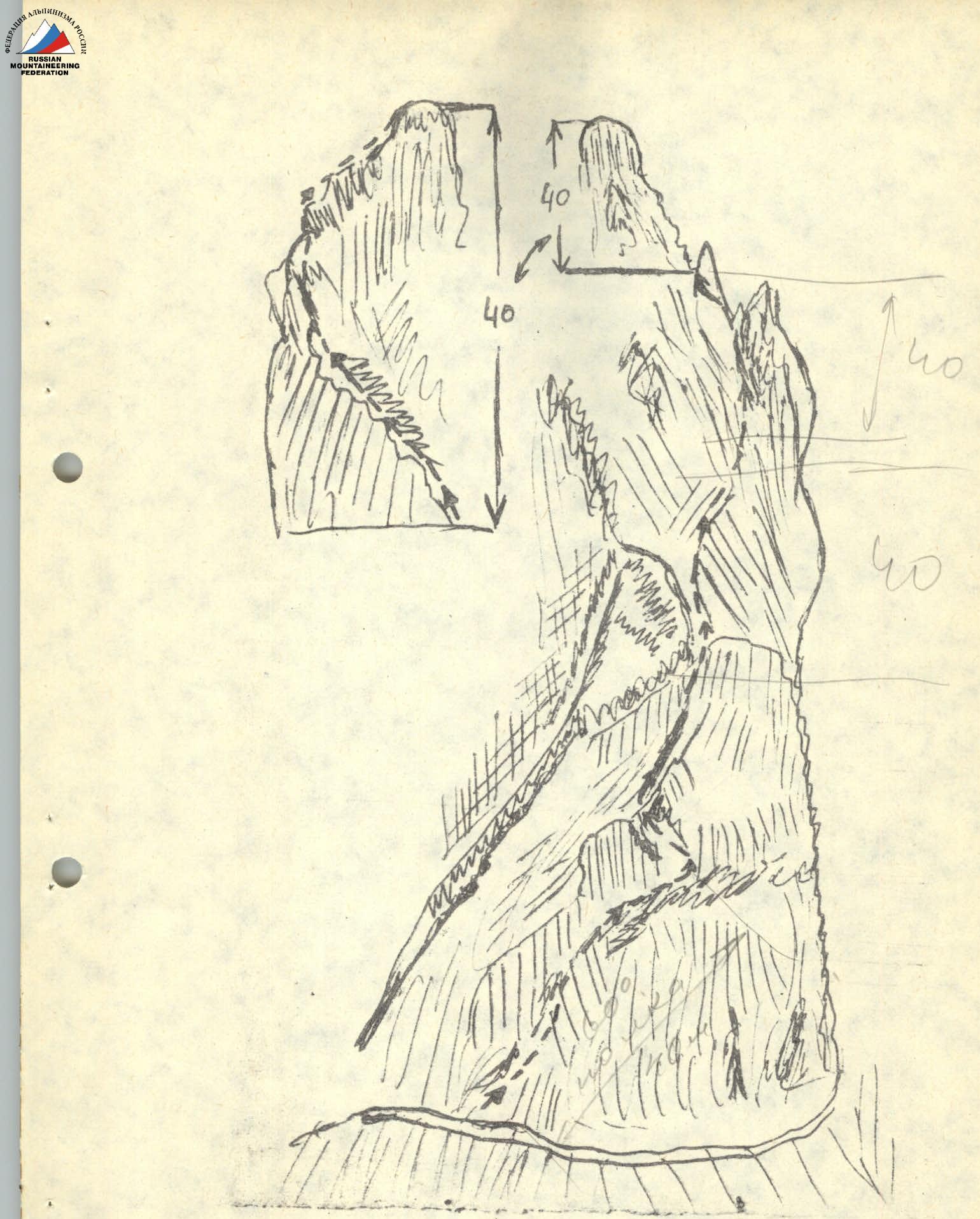
Section R3 (I control cairn)
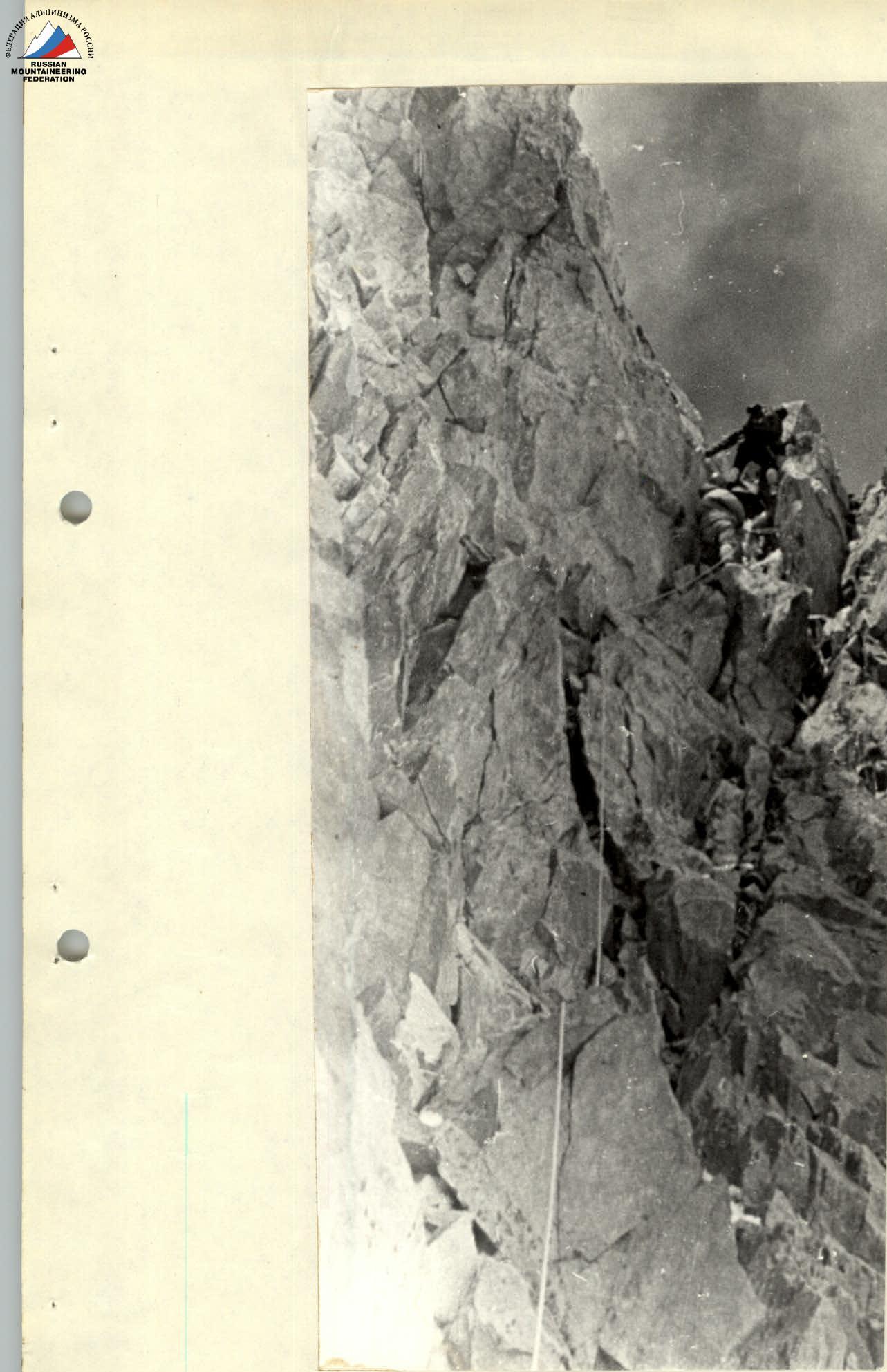
Diagram of section R10