Fig. 24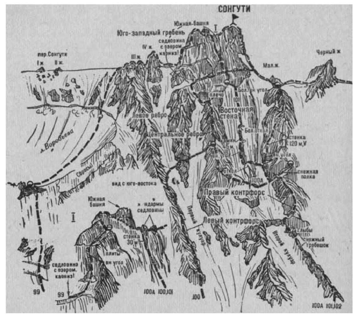
Fig. 25
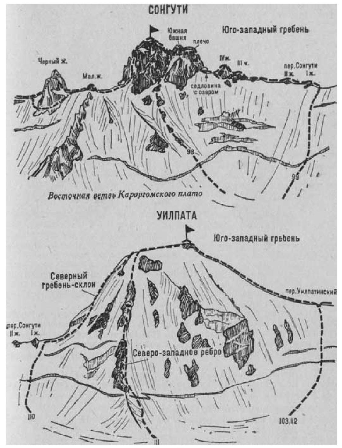
- Songuti (4368 m) via the Southwest Ridge (combined route, F. Zauberer, 4A cat. diff., Fig. 24–26).
The path from the village of Dzinaga (group of 4–8 people) to the initial bivouac on the platforms of the Western ridge of the Bivouachnaya peak is described in route 83.
From the platforms, along the Eastern branch of the Karaugom plateau (closed crevices), approach the right side of the col of the Songuti pass, connecting the Songuti peak on the left with Uilpata on the right. From the plateau, ascend a snow slope to the bergschrund, cross it via a snow bridge, and move 200–250 m straight up a steep ice-snow slope (avalanche danger — piton protection). Then, overcoming the upper crevice, ascend a steep ice-snow slope (avalanche danger — piton protection) for 100 m to the Songuti pass. From the initial bivouac, 3–5 hours.
Alternative ascent to the Songuti pass from the CSP of the Tsey region. The path from the CSP to the Lower Ice Overnight Camps on the right-bank moraine of the Tsey glacier is described in route 83.
From the overnight camps:
- Turn right and ascend the scree slopes of the right bank of the Uilpatinka river.
- Cross the stream and move up along the trail on the left bank of the Uilpatinka, flowing in a narrow canyon.
- Beyond the canyon, ascend grassy slopes, then "ram's foreheads" (rockfall).
- Reach the sandy platforms near the lake under the tongue of the Uilpatinsky glacier.
From the CSP of the Tsey region — 4–5 hours.
From the lake, a steep ascent up the ice slope to the glacier tongue. Further, bypassing crevices and the lower part of the icefall on the right side, reach its narrowest part, which is also passed on the right side.
Along the surface right moraine of the glacier, reach its upper snow plateau. On the right side of the plateau, on the southeastern buttress of the peak Oniani, there are good platforms — Volgin's overnight camps.
From the CSP of the Tsey region to Volgin's overnight camps — 7–8 hours.
From the point of exit to the plateau, cross it to the left and approach the snow slope under the col of the ridge-spur, departing from the right side of the Songuti pass to the east, between the ice falls on the right and the Western ridge of SKVO on the left.
From the plateau, overcoming the bergschrund, ascend a steep snow slope, then simple, weathered, and snow-covered rocks to the ridge-spur, left of the hanging ice falls. Here, turn left and reach the rocky platforms of Vorobiev's overnight camps.
- From Volgin's overnight camps — 3–4 hours
- From the CSP of the Tsey region — 10–12 hours
On the platforms, the initial bivouac is set.
From the platforms (exit to the ridge), turn right. Ascend the right side of the wide ice-snow slope of the Vorobiev glacier, left of the ice falls of the ridge-spur, in the direction of the Songuti pass, located between the peaks of Uilpata on the left and Songuti on the right.
From the glacier, having passed along the snow bridge over the bergschrund, move up along the wide, steep snow slope — a couloir on the right or left of the wall of the elongated rocky ridge (avalanches, rockfall).
Along the heavily destroyed, possibly snow-covered, couloir, ascend to the Southwest ridge of the Songuti peak, right of the II pinnacle of the Songuti pass.
Here, turn right and ascend the simple, gently sloping, snow-covered rocky Southwest ridge. A small III pinnacle is passed directly, can be bypassed on the left (protection).
Further along the simple, snow-covered rocky ridge, reach the IV pinnacle, which:
- is overcome directly along steep rocks of medium difficulty
- or bypassed on the left along a steep ice slope (piton protection)
From the pinnacle, along simple rocks of the destroyed couloir, descend to a snow col. Along the steep snow slope on the left side of the col ridge (cornices on the right), reach a platform with a lake. Here, organize a bivouac. From the initial bivouac — 5–8 hours.
From the lake:
- along a steep snow slope (cornices on the right), approach under the wall of the South tower of the peak
- from here, 20 m straight up along rocks of above medium difficulty
- then 20–25 m along steep, destroyed, medium difficulty rocks of the inner corner — a crack (piton protection) — a 40–45-meter wall ascent to a ledge
- from it, along plate-like steep rocks of above medium difficulty, ascend to a platform
- further along simple and medium difficulty rocks — to the shoulder of the South tower of the peak
- along the ridge of the shoulder, approach under the ascent of the South tower
- from here, along simple but steep rocks on the left side, descend to a platform of the col between the South tower peaks
from the platform, along the col ridge, bypassing:
- the first small pinnacle on the left
- and the second on the right
approach under the summit tower.
From the col, along steep rocks of medium difficulty, then along the left side of a smooth plate (piton protection), 20 m up to the "Iron" platform. From the platform:
- along a 15-meter steep couloir of the wall,
- then along rocks of medium difficulty, 120–150 meters of the summit ridge — ascent to the Songuti peak.
From the col with a lake — 6–8 hours.
Descent along the ascent route with rappels from the walls to the col with a lake takes 4–6 hours. The duration of the route is 3–4 days.
Naumov A. F. Karaugom, Digoria, Tsey (Central Caucasus), M., "Fizkultura i sport", 1976.