ASCENT PASSPORT
I. Climbing category: technical 2. Climbing area: Caucasus (2.7 from Gurdzyvcek Pass to Mamisson Pass), p. Passionarii 4000 m, via West wall of the bastion and Northwest ridge 3. Peak, its height, and ascent route 4. Proposed difficulty category: 5A cat. diff. 5. Route characteristics: Height difference: 940 m Length of sections with 5th-6th cat. diff.: 290 m Average steepness: 42° 6. Pitons driven: for belaying: rock 29 ice 2 bolt – for creating ITO: rock 4 ice – bolt – 7. Number of walking hours: 14 8. Number of overnight stays and their characteristics: one (at the summit), comfortable 9. Full name of the leader, participants, and their qualifications: Gorbachevsky Alexander Dmitrievich — 1st sports category Krivov Vasily Nikolaevich — 1st sports category 10. Team coach: MS USSR Shchepalova Galina Nikolaevna II. Date of departure and return: August 7-8, 1978
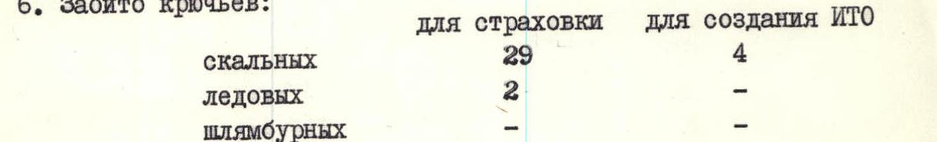
TABLE OF MAIN ROUTE CHARACTERISTICS
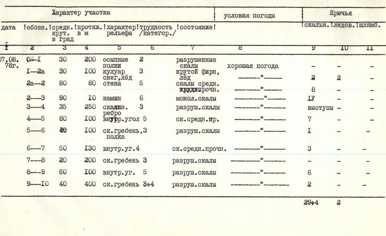
| Date | Designation | Average steepness, in degrees | Length, in m | Terrain character | Difficulty (category) | Condition | Weather conditions | Rock | Ice | Bolt |
|---|---|---|---|---|---|---|---|---|---|---|
| 07.08.1978 | R0–R1 | 30 | 200 | scree shelves | 2 | broken rocks | good weather | – | – | – |
| R1–R2a | 30 | 100 | couloir, snow, ice | 3 | steep firn, ice | " | 2 | 2 | – | |
| R2a–R2 | 80 | 80 | wall | 5 | rocks of medium strength | " | 8 | – | – | |
| R2–R3 | 90 | 10 | chimney | 6 | monolithic rocks | " | 14 | – | – | |
| R3–R4 | 35 | 250 | rocky ridge | 3 | broken rocks | " | – | – | – | |
| R4–R5 | 80 | 100 | inner corner | 5 | rocks of medium strength | " | 7 | – | – | |
| R5–R6 | 40 | 100 | rocky ridge, shelf | 3 | broken rocks | " | 1 | – | – | |
| R6–R7 | 50 | 130 | inner corner | 4 | rocks of medium strength | " | 3 | – | – | |
| R7–R8 | 20 | 200 | rocky ridge | 3 | broken rocks | " | – | – | – | |
| R8–R9 | 60 | 100 | inner corner | 5 | broken rocks | " | 6 | – | – | |
| R9–R10 | 40 | 400 | rocky ridge | 3–4 | broken rocks | " | 2 | – | – |
Total: rock 29 + 4 = 33, ice 2.
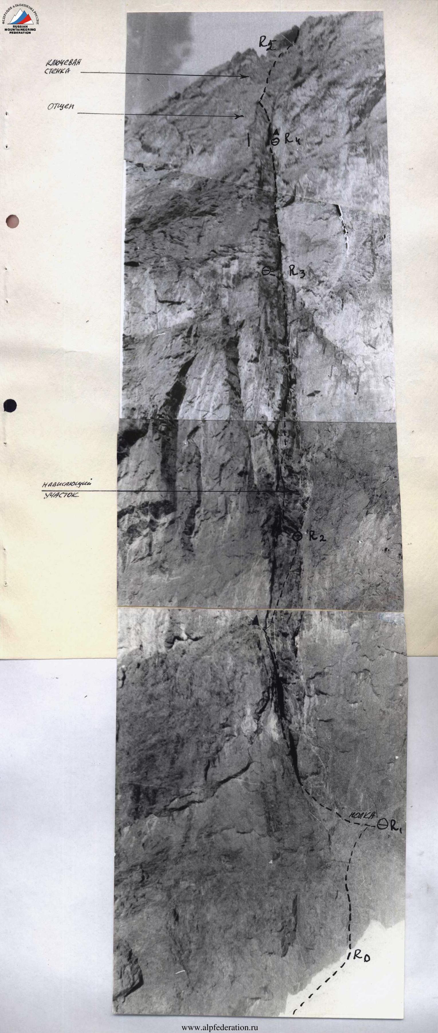
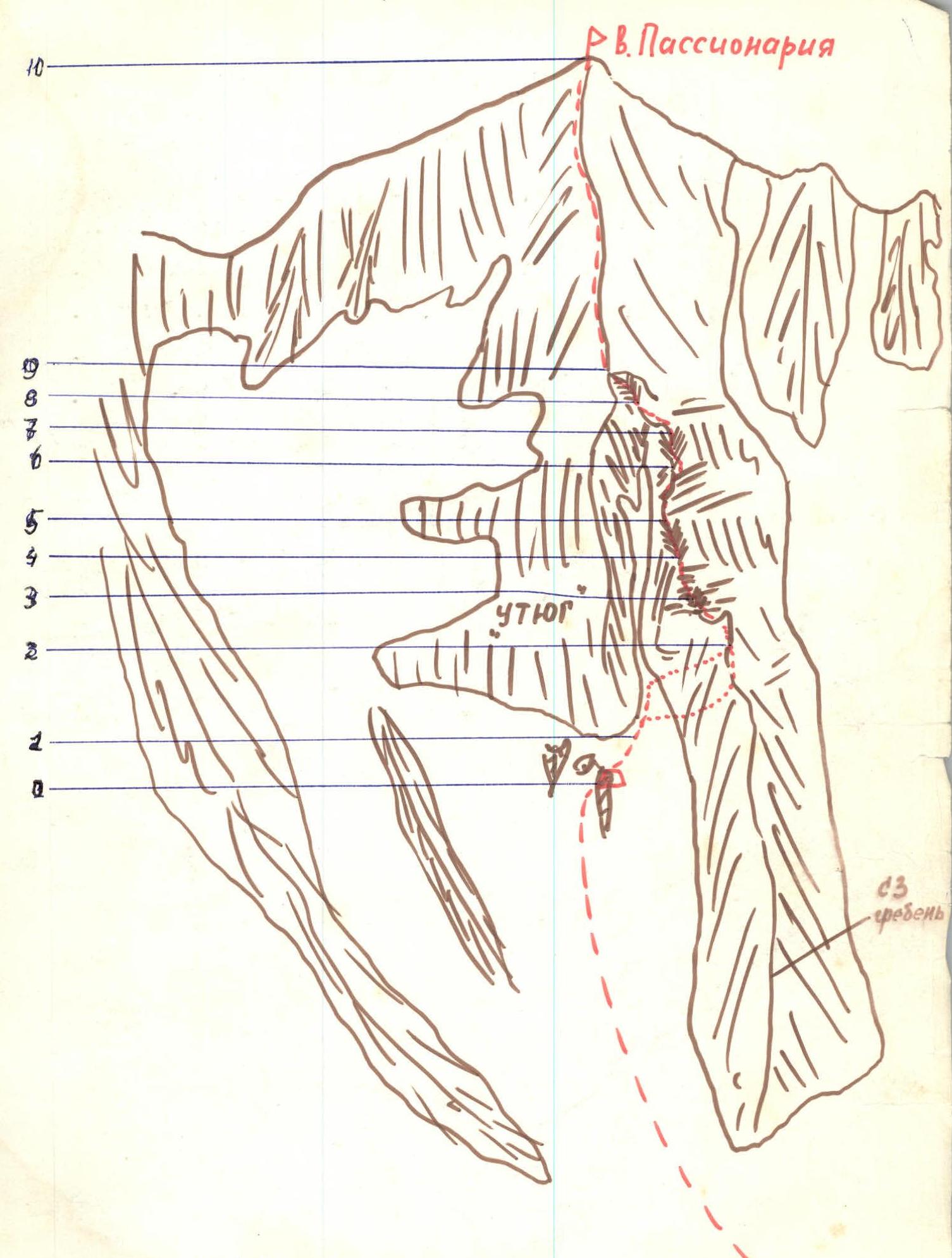 Route diagram and its division into sections.
PASSIONARIA VIA WEST WALL OF THE BASTION AND NORTHWEST RIDGE (Vasiliev's route)
The route description is given in sections (see table).
From the CSP of the Tsey district, follow the trail on the left bank of the Skazdon River to approach the "green" hill of the left-bank moraine of the Skazsky glacier. From the "green" hill, turn left and ascend via scree (at the beginning of summer — via a snowy slope) to the gates of a wide snowy couloir with a huge sharp rock at the entrance. Behind the rock, turn immediately left into the couloir descending from the Western Passionaria glacier, which lies between the peak of Vils and the peak of Passionaria.
On the right side of this couloir — ascent to the place of its bifurcation, then via the right branch of the ice-snow couloir (on the left — ice falls) and, bypassing rocky islands, exit onto their platforms 100 m from the base of the "Bastion" ("Iron"), standing to the left of the Northwest ridge of the peak Passionaria.
On the platforms of the islands — initial bivouac (from CSP of Tsey district — 3-4 hours).
- From the overnight stay under the "Iron" 100-200 m to the right-up via scree shelves to the entrance to the couloir separating the "Bastion" and the Northwest ridge.
- Further up via the left side of the ice-snow couloir, adhering to the wall of the "Bastion". Two options are possible here depending on the state of the route: Option 1 — via the couloir to a narrow canyon with an overhanging rocky plug. Then via the rocky wall of the couloir to the right 20-30 m (rocks of medium difficulty) — onto a shelf. Then up via difficult rocks, piton belay, exit onto the Northwest ridge under the gendarme "Finger". Option 2 (if the couloir is exposed to falling rocks) — via the left side of the couloir up to the turn of the couloir to the left. Movement is carried out under the cover of the "Iron" wall. Then it is necessary to cross the couloir to the right (one rope, crampons) and exit onto scree shelves. Then to the right-up via simple rocks along the wall of the couloir 40 m to the inner corner. Via the inner corner (difficult climbing) 40 m — exit onto the ridge. Via the ridge, via rocks of medium difficulty under the gendarme "Finger".
- The gendarme "Finger" is bypassed in a spiral from left-up to right. Control cairn. Then via the ridge 10 m to the chimney. Via the chimney (10 m difficult climbing, ladders) — exit onto scree shelves (live rocks).
- Via scree shelves and rocks of medium difficulty 250 m to the inner corner.
- Via the left part of the inner corner (100 m) via rocks of medium difficulty onto the Northwest ridge.
- Via the Northwest ridge — two ropes to the wall of the bastion, then without losing height (traversing the wall to the right via a shelf 70-100 m, piton belay) — to the inner corner. Possible bivouac site, water.
- Via the inner corner, first via difficult, and then via rocks of medium difficulty, three ropes — exit onto the Northwest ridge. Control cairn. To the left, 20 meters away — a narrow deep canyon separating the Northwest ridge and the bastion of the "Iron".
- Further via simple and medium difficulty rocks of the ridge 200 m to the inner corner descending from the saddle between the Northwest ridge and the bastion of the "Iron".
- Via the inner corner — 100 m onto the saddle between the Northwest ridge and the bastion. Overnight stay is possible.
- From the saddle via the Northwest ridge under the gendarme "Finger", overcome head-on via a difficult wall with a simple descent behind it onto the ridge. From here, ascent via smooth slabs of the ridge or via its right side under the gendarme II, which should be bypassed via steep broken rocks on the left. Further via rocks of medium and above medium difficulty on the left side of the Northwest ridge, then via a snowy saddle to reach a large gendarme. The large gendarme is bypassed on the left with an ascent via steep, heavily broken rocks onto a sharp ridge. From here, via the sharp Northwest ridge, approach under the pre-summit gendarme. Via a steep ascent above medium difficulty, ascend under the summit tower of the gendarme and, bypassing it on the left via shelves and simple rocks of the Northwest ridge, ascend to the peak Passionaria.
The entire route takes about 14 hours. Recommendations for climbers:
- Have crampons in case of ice in the couloir.
- Rock pitons 20-25 pieces.
- Consumable rope 10 m.
- Depart from the bivouac under the "Iron" no later than 3-4 am.
EXCERPT FROM THE ASCENT REVIEW PROTOCOL
Releasing (Shchepalova): "How do you assess the complexity category of the route and its compliance with the description of the first ascenders?"
Gorbachevsky: "We evaluated it as 5A cat. diff., it probably doesn't deserve more".
Krivov: "The description is generally clear and allows for orientation on the route. We divided the route into sections a bit more clearly in the description, as it seems to us. The declared category of difficulty corresponds to the route".
Releasing: "I consider it possible to count the ascent and ask the group to prepare a report on the third passage. One copy to be given to the CSP of the Tsey district, the other — to the Alpinism Federation of the USSR".