Ascent Passport
-
Category: ice and snow climb
-
Caucasus, Tsey Gorge
-
Mamisong, 4358 m, via the left icefall of the north face
-
Proposed route — Category 5B difficulty, first ascent
-
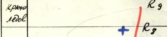
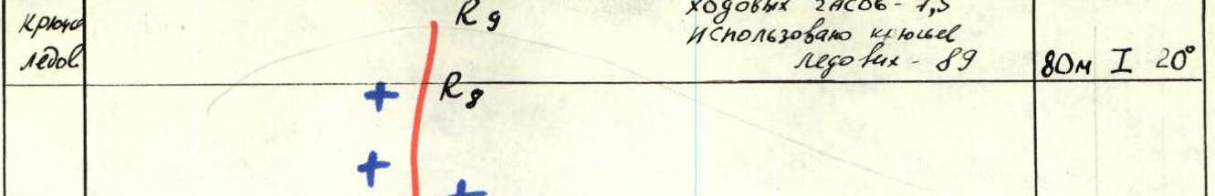
Elevation gain: 780 m, route length 1060 m.
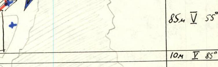
Length of Category 5B sections — 380 m, average steepness of the main part of the route — 60° (3820 m — 4140 m).
-
Ice screws used: 89
-
Team's climbing hours — 7, days — II.
-
No overnight stays.
-
Team leader: Leonid Borisovich Volkov, Master of Sports
Team members: Boris Markovich Polyakovsky, Candidate for Master of Sports; Pavel Petrovich Sizonov, 1st sports category; Petr Vladimirovich Evteev, Candidate for Master of Sports.
-
Coach: Valentin Stepanovich Neborak, Master of Sports.
-
Entry to and exit from the route — July 6, 1984.
-
Alplager "Tsey" of the All-Union Central Council of Trade Unions.

Photo 1. Mt. Mamisong from the north. "Helios 44" lens with teleconverter. Point 1. C=3000 m, h=3800 m. July 4, 1984. Routes marked:
- via North ridge, 5A category (Barov, 1954)
- via the right icefall of the North face, 5B category (Shopin, 1983)
- via the right part of the North face, 5B category (Bodnik, 1980)
- Route of the "Tsey" team, first ascent, 1984
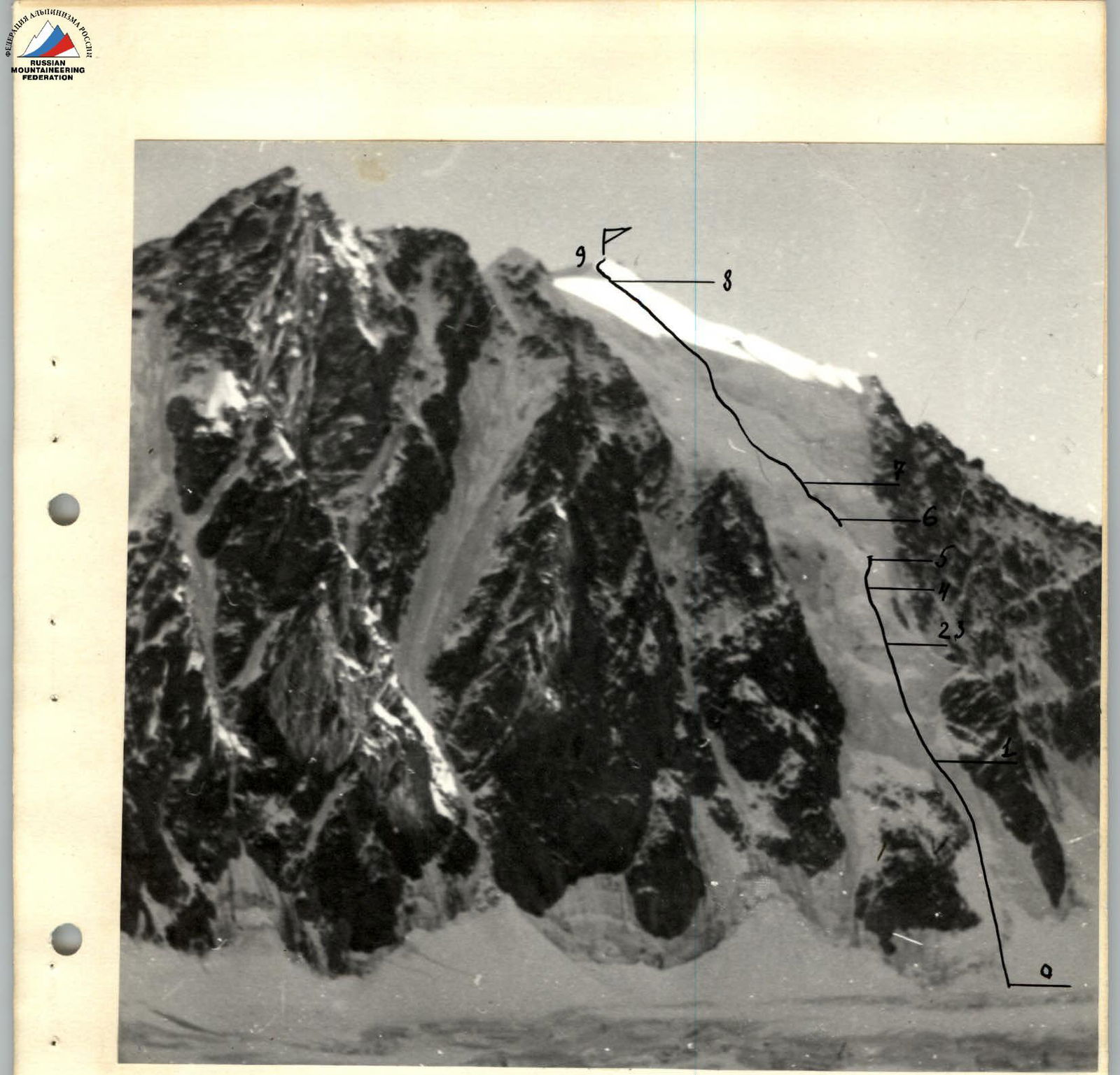
Photo 2. Profile of the left part of the wall. Point 2. "Helios-44" lens, C=2000 m, h=3400 m. July 3, 1984, 18:30
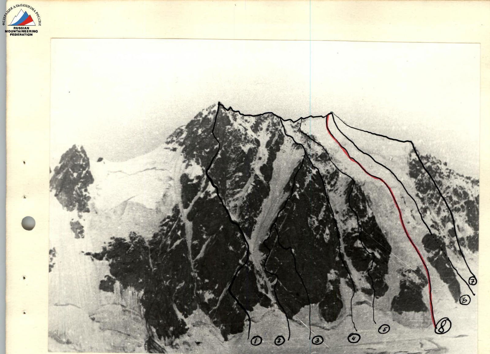
Photo 3. Panorama of the Mamisong massif from the north. Point 3. h=3400 m, C=2000 m. "Helios-44" lens, July 3, 1984, 17:00. Routes marked:
- via North ridge of the East shoulder (Bolchisevsky) — 5A category
- via the left edge of the "Triangle" on the North face (Polevoy) — 5B category
- via the center of the "Triangle" on the North face (Rusyayev) — 5B category
- via the right edge of the "Triangle" on the North face (Grigorenko-Prigoda) — 5B category
- via the North buttress (K. Barov) — 5A category
- via the right icefall of the North face (Shopin) — 5B category
- via the right part of the North face (Bodnik) — 5B category
- Route via the left icefall of the North face, ascended by L. Volkov's team, 1984
Overview of the ascent area (exploration of the Mamisong massif)
Mamisong peak, 4358 m, along with ChanchaKhi, is the most interesting mountaineering area in the Tsey region. There are 10 classified routes on Mamisong, 8 of which are on the North face, all with a difficulty category of 5. The exploration of this massif illustrates the development of mountaineering in the Soviet Union.
In 1948–1949, simple routes of 3A and 3B categories were laid from the south. Then the North face was explored, starting with simpler routes on the North buttress (K. Barov, 1954) and the North ridge of the East shoulder (Yu. Bolizhevsky, 1964) — both 5A category. Later, attention turned to the steep rocks of the "Triangle" on the North face (G. Polevoy's route along the left edge of the triangle, 5B category, 1964, and Yu. Grigorenko-Prigoda's route along the right edge, 5B category, 1967).
In 1972, V. Obruchnikov's group ascended the North face, and it seemed that there were no more logical routes left. However, experts considered the route through the center of the "Triangle" on the North face a "problematic" route in the Tsey region, but the possibility of traversing hanging glaciers was not even discussed.
In 1980, Vitaly Bodnik, with his characteristic boldness, "scoped out" and ascended an interesting route "via the right part of the North face," 5B category. Meanwhile, ice climbing techniques improved, new equipment appeared, and ice walls became more attractive.
In 1983, Leningrad athletes completed the exploration of the "Triangle" by laying a 5B category route through its center and "tackled" the ice by overcoming the right icefall on the North face (5B category). The same year, the "Tsey" team attempted to ascend the left icefall but gave up due to weather conditions.
And so, the ninth route from the north on Mamisong was completed. It is worth noting that our route is not identical to V. Shopin's route via the right icefall. Although the average steepness of the routes appears to be the same, the left icefall is characterized by a sharp dissection of the glacier body, a greater variety of ice relief — from smooth ice slopes to areas of ice jumble, ice icicles, and steep firn-ice walls in the middle part of the route. The average steepness (48°) is similar to that of the well-known ice routes on the North face of Dykhtau via Abalakov's route (49°) and V. Grishchenko's route on East Mizhirgi (47°).
Preparation for the ascent
The route via the left icefall on the North face of Mamisong interested the "Tsey" team back in 1983 when they were preparing for the USSR Championship (ice and snow climbing class).
The team planned to ascend it as a training climb before the Championship, but it didn't happen due to a lack of time for observation and reconnaissance.
The route became more appealing after:
- V. Shopin's team ascended the right icefall on the North face in the same season;
- after participating in the Championship (on Dykhtau's North face), four instructors from the camp, led by L. Volkov, embarked on a first ascent.
For 2 days (August 24 and 25, 1983), the team observed the icefall and photographed the route.
The day before the ascent, the weather worsened significantly, and the climb was cancelled. However, the team planned to attempt the icefall as part of the 1984 K TUA Championship.
Immediately before the ascent, the team, in its final composition, conducted training sessions on the Tsey icefall, practicing technical techniques for moving on steep ice. They tested:
- Ice screws;
- Homemade "rigid" crampons;
- Titanium ice screws.
All team members passed physical fitness tests with excellent marks. Two team members (L. Volkov and P. Sizonov) spent two days in the Mamisong cirque, observing the route directly before the ascent. As a result, a tactical plan was developed, and the final route through the icefall was determined. A nighttime ascent through the center of the hanging glacier was considered the safest, as the right (orographic) edge of the icefall is prone to serac collapses, and rockfall is possible along the left edge (see "Additions").
Ascent schedule
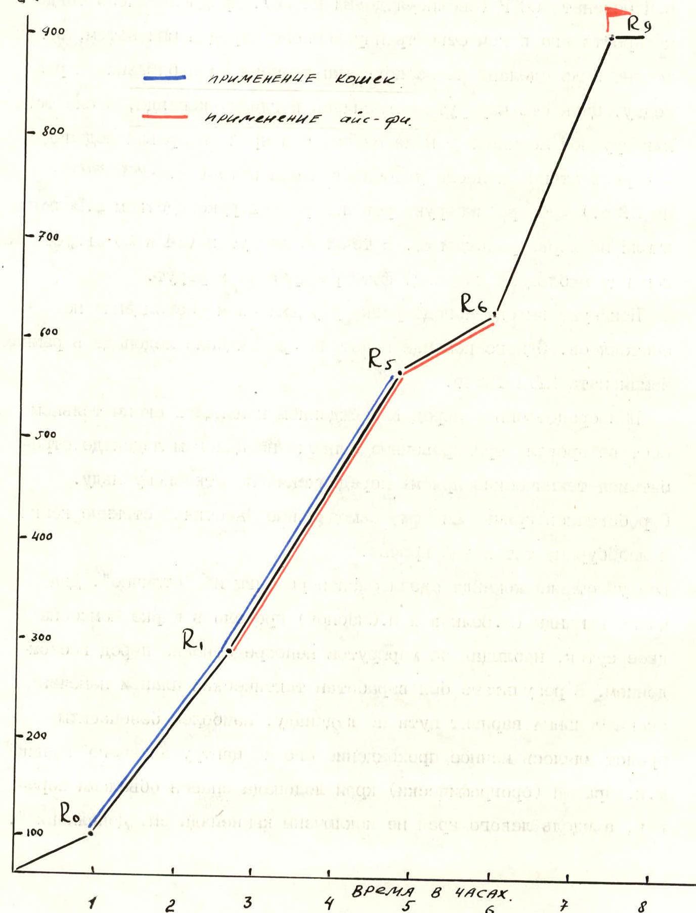
Technical actions of the team
The planned tactical ascent plan was followed in every detail (early nighttime start on the route, movement through the center of the icefall). The lower section (ice slope) was ascended using front points with careful piton protection. The team moved under the cover of the left (orographic) edge of the rocky outcrop.
The path through the middle section (sections R1–R7) is practically safe from rockfall and ice avalanches. Here, the team could rest while moving at a slower pace through more complex terrain (using ice axes). Here, as in the lower part, the rope teams moved independently.
To avoid losing ice screws in the dark, the following measures were taken:
- The second climber in the second rope team followed at a minimal distance from the lead climber;
- This allowed for quick equipment transfer to the lead rope team.
Particular attention was paid to clear, concise commands in the complete darkness. All four team members used headlamps, but dense fog reduced visibility to a minimum.
The ascent night was exceptionally warm, so one of the key sections — a steep ice-firn wall ("lopata") — was ascended via a more complex but safer variant (on its left side, where the "lopata" is higher and steeper), leading to a safe ridge.
On this section, the following proved particularly useful:
- Long, large-diameter ice screws;
- Ice axes with firn blades.
On the upper part of the "lopata" wall, ice screws were placed at intervals of no more than 1 m; often, for added reliability. Intermediate protection points on loose ice required blocking with two screws. Ropes were used on this section — the technically complex area was ascended solo by the first climber to reduce the risk of falls (R5–R6).
Throughout the route, the lead climber rotated, and the rope teams alternated. All team members worked as lead climbers evenly.
There were no injuries, falls, or other hazardous situations during the ascent. The first communication with the camp (at 7:45) was made from the main ridge of the summit.
| | | |
| : Q--------------------------------------------------------------------------------------------------------------------------------------------------------: | :--------------------------------------------------------------------------------------------------------------------------------------------------------: | :---------------------------------------------------------------------------------------------------------------------------------------------------------: |
|  |
|  |
|  |
|
|
|  |
|  |
|  |
|
|
|  |
|  |
|  |
|
|
|  |
|  |
|  |
|
|
|  |
|  |
|  |
|
|
|  |
|  |
|  |
|
Description of the route by sections
From the bivouac under the North face of Mamisong, ascend via avalanche-prone cones to the bergschrund, heading towards the right (here and further — in the direction of travel) edge of the rocky outcrop.
R0–R1. Cross the bergschrund and exit onto an ice slope with a steepness of 45° (lower sections) to 50°. Ascend the slope directly upwards along the rocky outcrops. Section length 300 m.
R1–R2. The next section of the route — three consecutive ice "foreheads" (30 m each), separated by gentler (40°) ledges (10–15 m long). Steepness of the "foreheads" — 70–75°, length of the ledges between them — 10–15 m. Movement on the ledges is difficult due to snow. Total section length — 130 m.
- Ice wall ("forehead") — 30 m, 70–75°
- Ledge — 10–15 m, 40°
- Ice wall ("forehead") — 30 m, 70–75°
- Ledge — 10–15 m, 40°
- Ice wall ("forehead") — 30 m, 70–75°
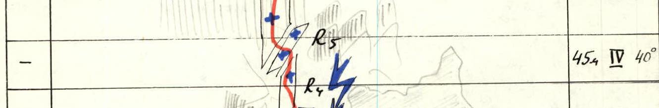
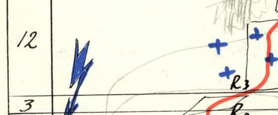
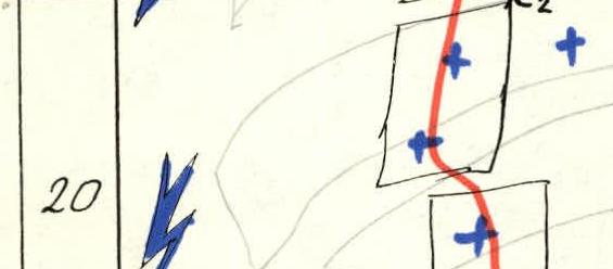
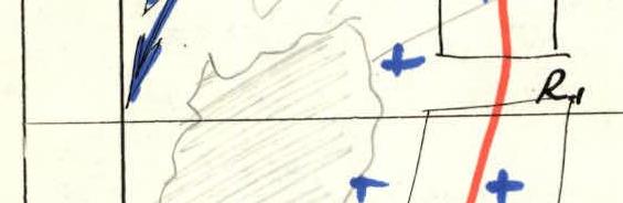
R2–R3. Then exit under an overhanging, "destroyed" ice wall. Further ascent is dangerous due to:
- Overhanging, unstable seracs;
- Ice collapses. Traverse right 10 m along a steep ice wall to the right edge of the overhang.
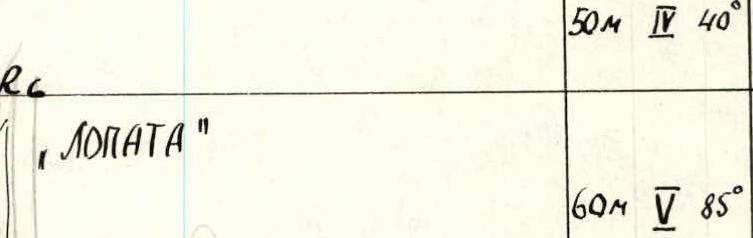
R3–R4. Continue up a 75° wall for 30 m to a snowy ledge (40°, 25 m), then to a second ice wall (70°, 30 m). The ice is partially unstable and layered (careful protection needed). Exit onto a snowy "shoulder".
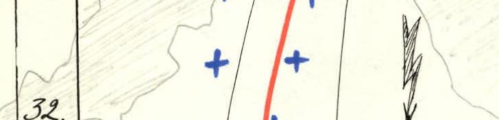
R4–R5. The "shoulder" has a steepness of 35°–40° and is 45 m long. It is overloaded with loose snow (avalanche risk 1). Move along the pronounced ridge of the "shoulder". Approach the key section of the route.
R5–R6. Ascend a steep ice-firn wall — 60 m, with a steepness of 85–90°. The first 40 m of the route are on smooth ice; above, the wall is composed of loose ice, mixed with firn and granular ice.
Recommendations:
- Careful protection;
- Use of long, large-diameter ice screws;
- First climber uses ice axes with firn blades.
Difficult exit from the wall onto the "lopata" — a saddle-shaped break in the firn field of Mamisong.
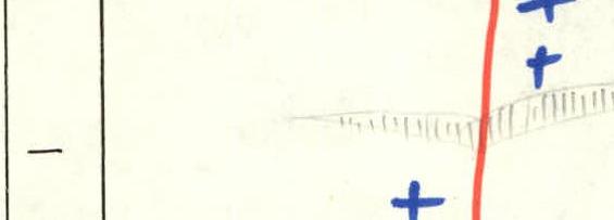
R6–R7. Continue, following the right edge — the ridge of the "lopata". (Danger of avalanches, deep, loose snow). Section length 50 m, steepness — 45°, easing to 30°. Approach under a wide gap in the firn plateau, traverse left 15 m to the easiest crossing point of the bergschrund. Cross the overhanging 2-meter wall of the bergschrund and continue on firn-snow fields towards the ridge, left of the final pitch. Slope steepness — from 35° in the lower sections to 45° before reaching the ridge. Two small bergschrunds are crossed along the way. Exit onto the main ridge of the summit.
R8–R9. Follow the ridge right for 80 m to reach the summit of Mamisong.
Team leader /L. E. Volkov/
Route recommendations
- The route via the left icefall on the North face of Mamisong changes significantly not only from year to year but also during different periods of a single season. Therefore, its actual condition and safe route options may not match our description. We recommend careful observation of the route for 1–2 days before attempting it.
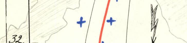
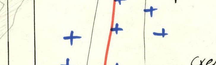
- Apparently, the left (in the direction of travel) edge of the icefall is always dangerous due to collapsing ice seracs, and rockfall is possible on the right. The exit onto the "lopata" via its center can be avalanche-prone (see "Additions" — Observations on the route).
- We recommend ascending the route without overnight stays. In case of a forced bivouac, safe locations are under the "lopata" wall or under the cover of the bergschrund (R7). Exiting onto the right rocky ridge is also recommended.
- At the debriefing, the head of the camp's rescue team, V. N. Sukharev, suggested monitoring the climbers regardless of their team size.
Photo 4. Technical photograph of the route. Point 4. "Helios-44" lens with teleconverter, C=2000 m, h=3800 m, June 4, 1984. Routes marked:
- via the right icefall of the North face (Shopin, 1983) 5B category
- via the left icefall (first ascent)
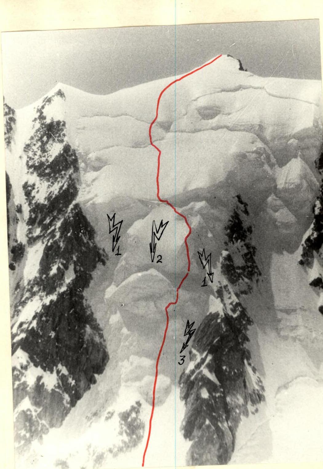
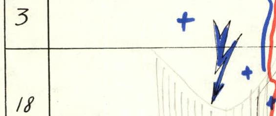
Photo 4. Observations on the route on July 4 and 5, 1984. Rationale for the chosen path and tactical plan.
- Sections prone to ice collapses on the left and right edges of the icefall.
- Area most prone to avalanches ("lopata").
- Rockfall-prone section. The safest route variant.


