Passport
- Climbing type: rock climbing
- Climbing region: Caucasus, 26: Komidon River valley
- Peak, route: KION-KHOKH peak (3420 m): from the South, right of the ridge
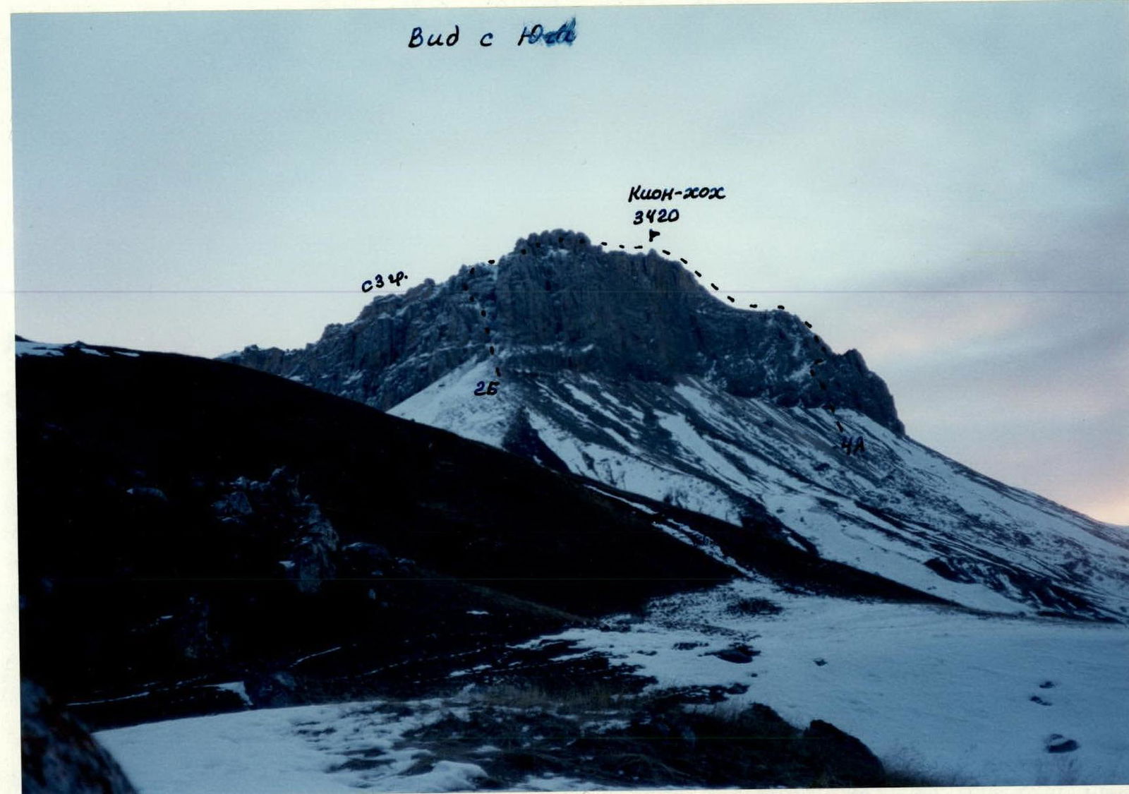
- Expected category of difficulty: 4A: partially explored
- Route characteristics:
height difference — 300 m, route length — 450 m, section lengths:
- 3 — 140 m
- 4 — 30 m
- 5 — 55 m, average steepness of the main part of the route — 60–70°
- Pitons hammered: rock — 8 pcs. закладных — none, ice screws — none
- Number of walking hours/days — 14/2
- Number of overnight stays: 1st on the approach 2nd on the descent bivouac at one location
- Leader: Levkovsky Yury Vasilyevich — 1st sports category. Lunyev Alexander Vladimirovich — 2nd sports category.
- Coach: Gudenko Vladimir Pavlovich — Candidate Master of Sports
- Entry to the route: October 4, 1996 return to bivouac: October 5, 1996
- Organization: FST RSO-A
Brief Overview of the Climbing Region
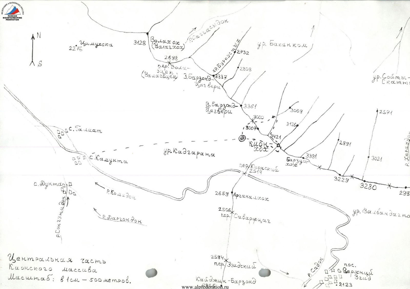
On the territory of the Republic of North Ossetia, between the Ardon River to the East and the Urukh River to the West, lies the Rocky Range with its highest peak, Ki-on-khokh (3420 m), in its central part.
The entire Rocky Range stretches in a latitudinal direction for 30 km. Its most interesting central part, from Vala-khokh peak (3128 m) to Khovtsek peak (3075 m), is 12 km long.
From the northern slopes of the Rocky Range, numerous streams flow, giving rise to the rivers:
- Tsrau-don
- Urs-don
- Dur-Dur
- and others.
On the southern side, the largest number of streams occur during the winter-spring period. The northern slopes of the range are extensive, heavily dissected by canyons, and have a large number of ridges. The upper part is formed by destroyed limestones, while the middle and lower parts on the North are covered with grass and forest, making them difficult to traverse. The southern slopes are rocky, steep, and drier, with height differences of up to 400 m.
The rocks that make up the Rocky Range are of sedimentary origin: limestones, dolomites, and locally marble.
On the southern side, there are many scree slopes in the upper part, and below are grassy slopes.
On this side, along the entire massif, a road has been laid, connecting the villages:
- Upper Zgid
- Kamunta via the Kionsky Pass (2514 m), from which approaches to the routes to the peaks of the Rocky Range are possible.
Previously, this region was explored by tourists who traversed routes through the passes:
- VALA-vtsek
- KHODSKY and others.
Alpinist ascents to the peaks of the range were practically non-existent, and there were no classified routes. Only since 1995 has the region begun to be explored by North Ossetian alpinists due to the convenience of ascending peaks during the winter-spring period.
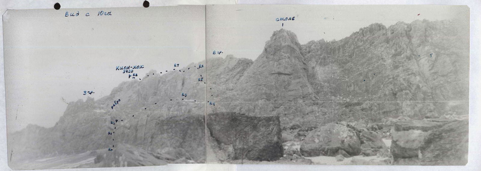
The Kion-khokh peak massif drops to the south with sheer walls composed of limestones and dolomites, with a height difference of up to 350–400 m, making them interesting for alpinists to climb. Against this backdrop, the following stand out:
- a huge monolithic stone pillar with overhangs
- a steep rocky ridge composed of dolomites to its left, in the area of which this route is laid.
Route Description
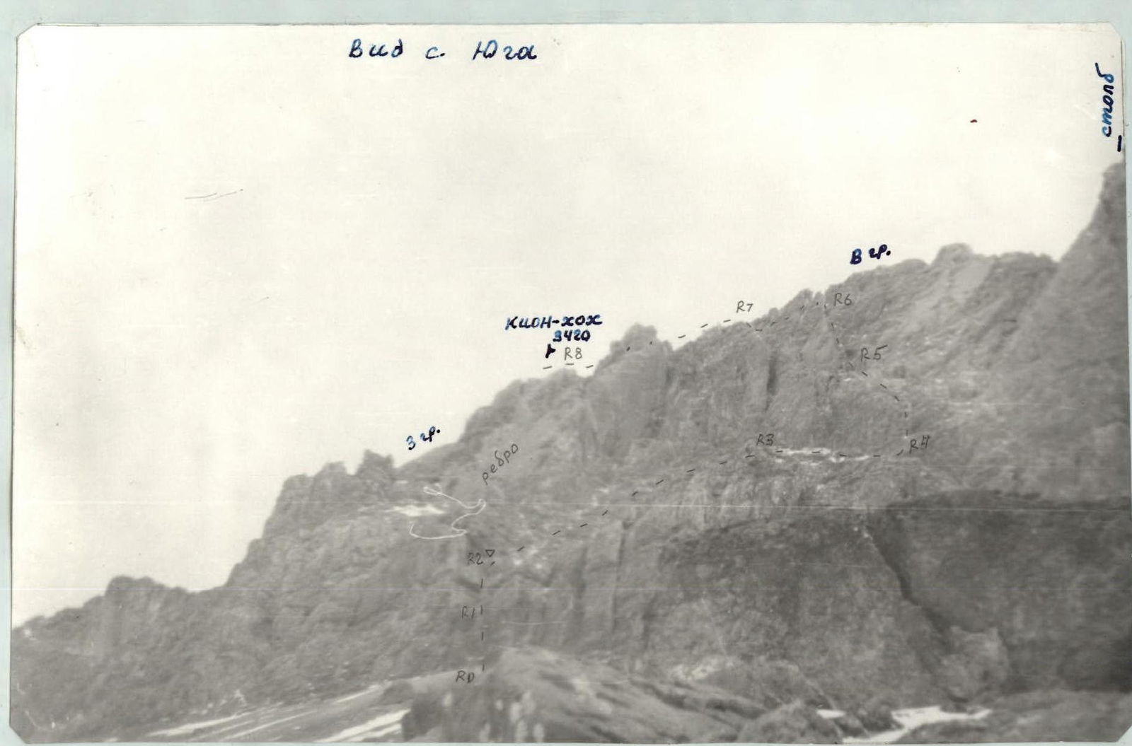
From the bivouac, move traversing right-upwards under the southern walls of the Kion-khokh peak massif (3420 m) in the direction of a clearly visible large, rising to the full height of the wall, and located to the right of the peak, monolithic stone pillar with overhangs. 120–150 m before the pillar, ascend a steep, fine scree slope for 200 m to the base of a steep ridge composed of dolomites. From the bivouac — 2 hours.
The starting point of the route is an internal corner, not visible from the approach, and open towards the pillar.
Up the internal corner, left-upwards for 25 m: 70°: 5 to a crevice, then 5 m: 90°: 5+, and further 5 m: 70°: 5 to a small ledge, where a good belay point is possible — 1st key section. From here, left-upwards on the left side (wall) of the internal corner with a small number of holds: 20 m: 70–80°: 5 to a large rocky-scree ledge on the right side of the ridge — 2nd key section. Control cairn.
It is advisable to pre-process these two sections by hanging a rope, which was done by the first ascenders.
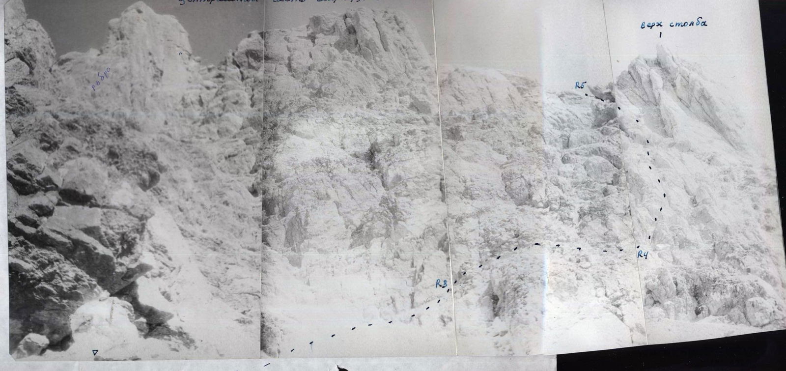
Further, move right-upwards on steep, destroyed rocks 3: 40–50 m and then on a steep scree slope, approach traversing right to the base of a rocky ridge, separated from the pillar by a steep rocky couloir in its middle part.
Ascend directly upwards on the rocks of the ridge 4: 25 m. Then 80–90 m: 2–3 to the base of a steep scree couloir.
Move upwards on the fine scree of the couloir to a large boulder in its middle part, which is bypassed on the right on the wall 4: 70°: 5 m and further upwards to a col under a steep wall on the right.
From the col, descend left on fine scree to the second steep scree couloir and exit onto it, then onto a col, from where descend left into the third couloir and exit onto the Eastern ridge of Kion-khokh peak.
From the control cairn — 5 hours. Turning left, ascend the simple rocky-scree ridge to Kion-khokh peak — 20 minutes.
Descent Description
Descend from Kion-khokh peak onto the Western ridge and along it, overcoming frequent obstacles of 2nd category of difficulty with a small number of holds, to the junction with the NW ridge. Move right onto the NW ridge and along the broad, simple ridge, descend 500 m to its lower part, from where, in one of the couloirs, left-downwards, exit north of the col between Barzond-Tsagveri peak and Kion-khokh peak. Ascending to the col, descend from it to the South to the bivouac. From the peak — 3–4 hours. View © Drz
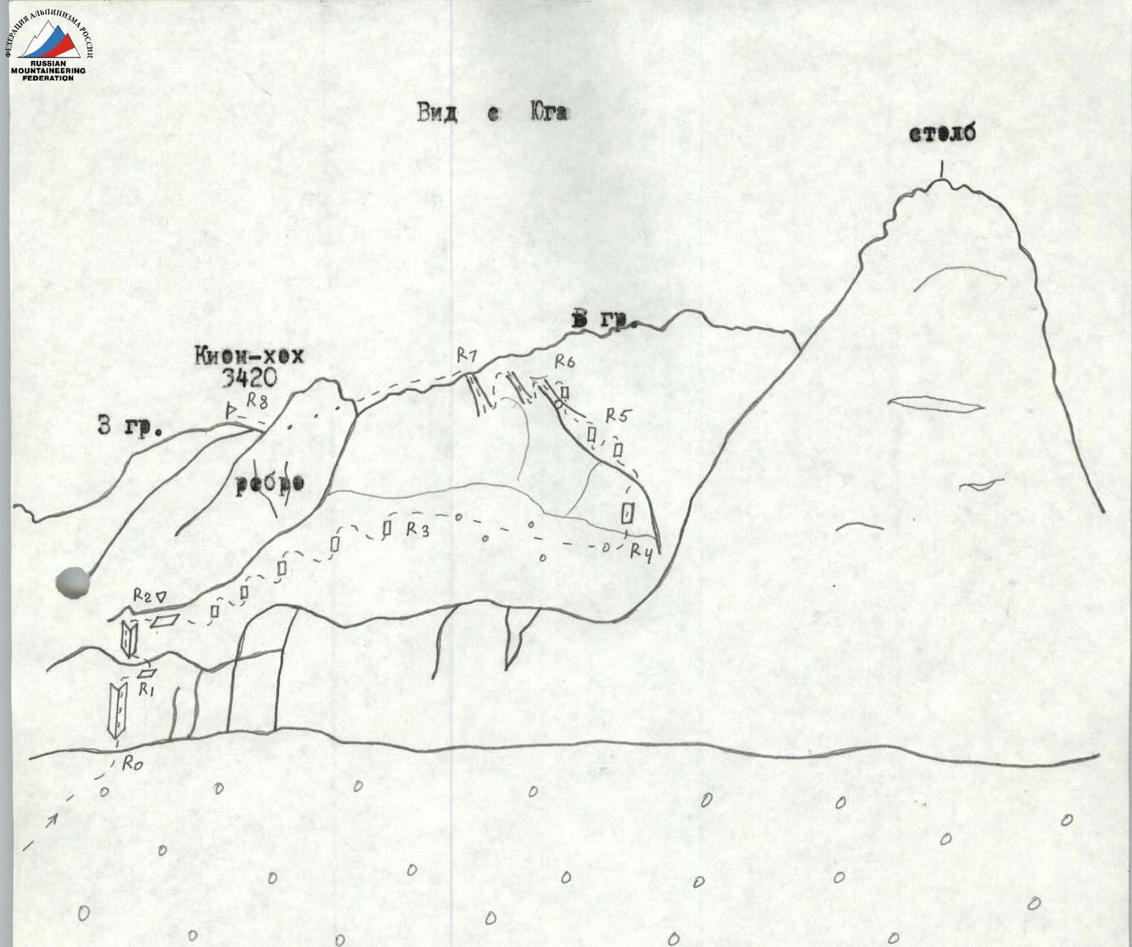
R0–R1–5+: 70–90°: 35 m — internal corner R1–R2–5: 70°: 20 m — internal corner R2–R3–3: 55°: 50 m — rocks R3–R4–1: 45°: 120 m — scree R4–R5–4: 70°: 20 m — wall R5–R6–2–4: 45° — rocks, couloir R6–R7–45°: 250 m — scree couloir R7–R8–40°: 200 m — rocky-scree ridge
2594 Zgidsky Kaydzhin-Barzond pass
 К. Т.
К. Т.