PASSPORT
Ascent to peak Kalper via the Northeast Edge.
- Category of ascent: Combined
- Area of ascent: Tsey, Kalper ridge
- Summit: Kalper, 3800 m, route via Northeast Edge
- Estimated category difficulty: 5A–4B
- Route characteristics: height difference –1100 m, length of sections with 5–6 category difficulty –250 m, average steepness – 45°
- Pitons used: for belay – 23, for artificial holds – 8, including rock pitons – 29, ice screws – 2.
- Duration: 20 hours
- Number of bivouacs: 2, with available tent sites.
- Participants: Vorotilin Vyacheslav Nikolayevich, Candidate Master of Sports, team leader Ryazhskey Boris Sergeyevich, Master of Sports Shagurin Vitaly Ivanovich, 1st sports category Khokhlov Ivan Grigoryevich, 1st sports category
- Team coach: Vorotilin V.N.
- Dates of departure and return: July 30, 1979 – August 1, 1979
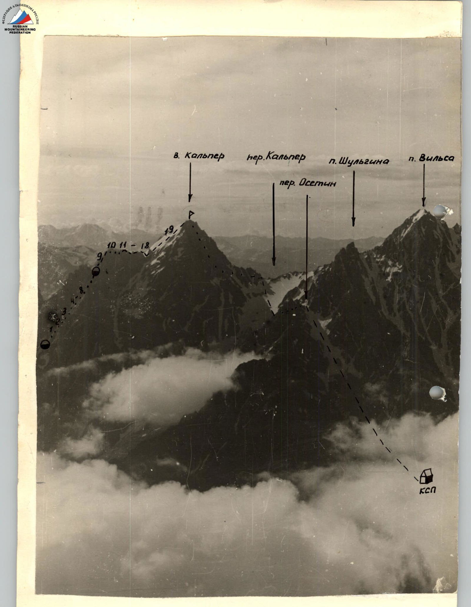
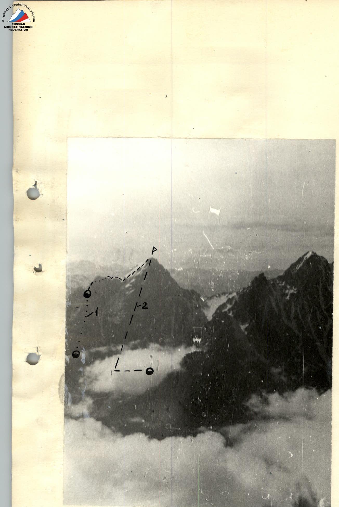
Photo 1. Panorama of the route:
- Group's route.
- Route via North Edge, category 4A.
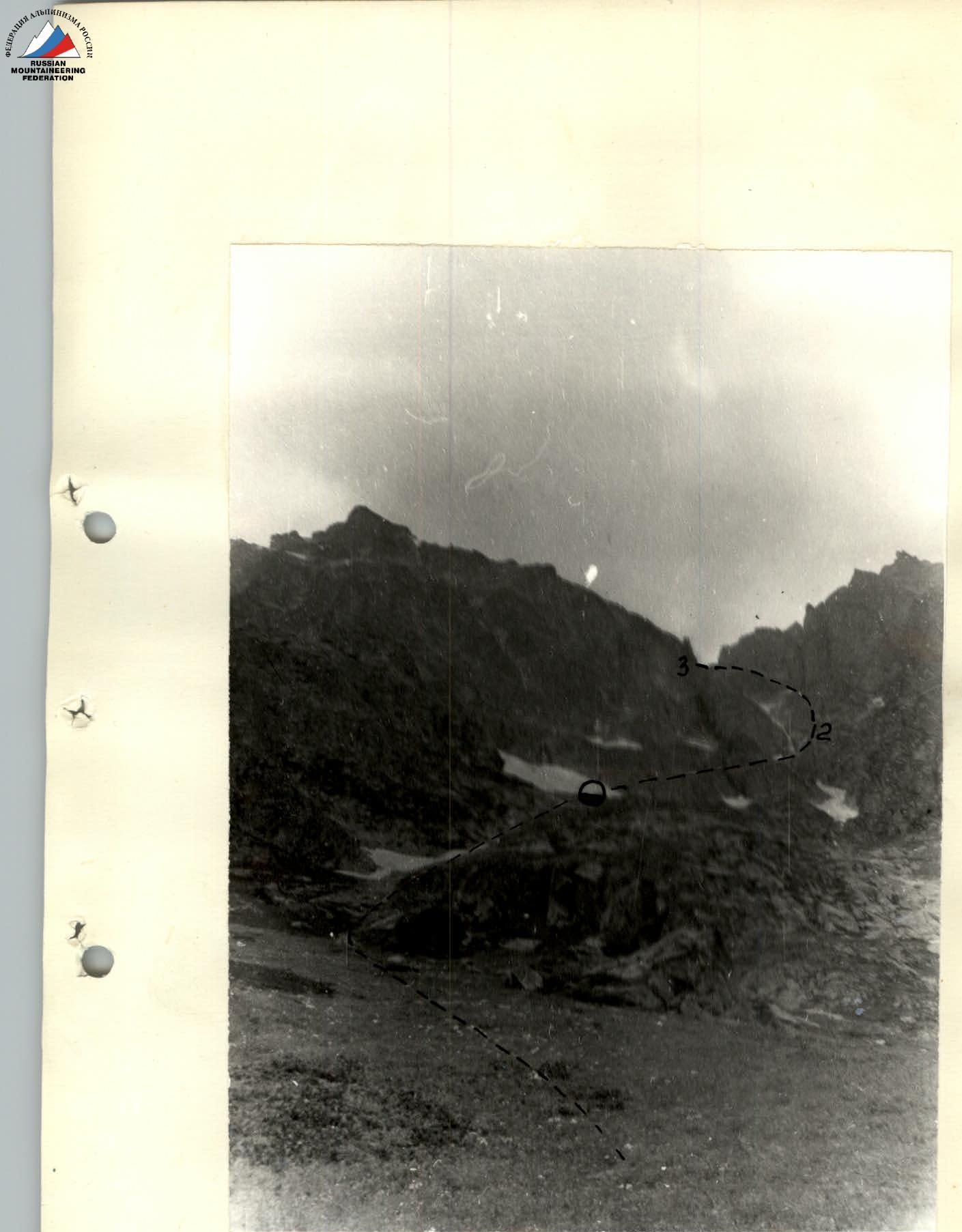
Photo 2. Beginning of the route. The Kalper ridge – the southeastern spur of peak Mamison – is a developed system of peaks and connecting ridges between the rivers Tseydon and Ardon, attracting the attention of mountaineers. Several routes of categories 2B to 5B have been established on the peaks of this ridge.
Among other mountaineering objects in the Kalper ridge, its extreme northeastern peak – Kalper (3800 m) – is of significant interest. Three classified routes have been established on peak Kalper:
- Via the Eastern slope of the South ridge (category 2B);
- Via the North Edge (category 4A);
- Via the Northwest wall (category 4A).
All these routes are purely rock routes and start from the Kalper glacier and the Vils glacier. Meanwhile, the eastern wall of the Kalper glacier, visible from the Vils gorge, and the northeast edge remain unexplored by climbers.
At the suggestion of a great enthusiast and excellent knowledge of the area, the head of CSP, Master of Sports B.S. Ryazhskey, the group chose the northeast edge of the peak for the first ascent, with an ascent to it via the rock wall from the Vils gorge. The northeast edge starts in the area of the confluence of the rivers Tseydon and Ardon and steeply rises to the peak in the form of a system of powerful tower-like gendarmes, bordering on the right an extensive snow-ice plate of the eastern slope. The ascent via the wall, dropping into the upper reaches of the Vils gorge, seems to be the most natural path to the northeast edge.
1. Approach to the route
From CSP of the Tsey region, down the highway to the settlement of Buron – 12 km, then left, up the highway to Zoromag – 2 km to the cable crossing over the Ardon river. Cross the river and move up the stream bed of the Vils gorge to the first waterfall – 1.5 hours from the mouth. The first waterfall is bypassed on the right via "barany lby". Then again along the stream bed to the second waterfall, which is bypassed on the left via "barany lby" (1 hour from the first waterfall). Then again along the stream bed to the edge of the shrub zone and further left-up along the grassy slopes of the right orographic bank of the stream to the "barany lby" under the start of the route. The "barany lby" are bypassed on the left via the talus. On the "barany lby" – a bivouac (2 hours from the second waterfall).
2. Route description
From the bivouac on the "barany lby", up the middle talus and then to the right to a snow patch, ascend in the direction of the waterfall descending from the wall. Further – into the right narrow couloir with sheer rock walls (300 m). The bottom of the couloir is an alternation of snow patches and very difficult rock walls-steps, 5 to 10 m high. The walls are overcome with piton belay using artificial holds. The length of the couloir is 120 m.
From the couloir, left to the saddle (R1 control tour). Further, crossing a wide snow couloir, left, up into a narrow snow couloir with two rock islands. Further ascent 100 m to the end of the couloir, from where, via a very difficult sheer 40-meter wall on the right, to a wide destroyed ridge (piton belay).
Then left up the ridge 120 m under the sheer wall of a gendarme (belay via outcrops). The sheer wall is bypassed on the left via a snow patch, abutting against a sheer chimney with a plug. Up the chimney 20 m – very difficult climbing with an exit onto the plug.
Further from the plug, the path goes along a wide talus couloir onto the saddle of the northeast edge. On the saddle – a bivouac. From the first bivouac – 10–12 hours.
From the saddle – left up the slabs of medium difficulty to ascend under the peak of R1 gendarme. The peak itself is bypassed on the left via ledges. Further, the path goes along the ridge, bypassing the second gendarme also on the left in the upper part. On R3 gendarme, the ascent is direct.
From its peak, a 10-meter rappel down the rope. A short traverse and a 40-meter rappel down to a sharp rock knife, separating R3 and R4 gendarmes. Along the knife (20 m), approach R4 gendarme, which is bypassed on the left via a characteristic flake and then via ledges in the middle part.
Further, a 40-meter rappel down to the base of the last, R5 gendarme, which is bypassed on the left along the boundary of rocks and snow and further along the snow-ice slope.
Above R5 gendarme on the ridge – R2 control tour. Further, the path passes along the snow-ice plate on crampons. On the ice sections, belay via ice screws. The plate leads to the destroyed rocks of the peak (from the bivouac on the saddle of the northeast edge – 10–12 hours). Descent – via the Southwest slope to Kalper 2B.
Table
Main characteristics of the ascent route.

| Date | Designation of point | Average steepness | Length in m | Character of terrain | Difficulty | Condition | Weather conditions | Pitons: Rock | Pitons: Ice | Pitons: Bolts |
|---|---|---|---|---|---|---|---|---|---|---|
| 31.07.1979 | R1 | 45° | 400 m | Snow slope | 3–4 | Firn | Fog | 6, outcrops | ||
| R2 | 50° | 120 m | Rock couloir | 5 | Smoothed rocks | Fog | ||||
| R3 | 45° | 100 m | Snow-ice couloir | 3 | Firn | Fog, snowfall | 8 | |||
| R4 | 85° | 40 m | Rock wall | 5 | Smoothed rocks, ice crust | Fog, snowfall | ||||
| R5 | 45° | 120 m | Wide rock ridge | 2–3 | Destroyed rocks | "–" | outcrops | |||
| R6 | 45° | 80 m | Snow couloir | 3 | Firn | "–" | ||||
| R7 | 90° | 20 m | Chimney with a plug | 5 | Smoothed rocks | "–" | 4, outcrops | |||
| R8 | 45° | 100 m | Rock couloir | 2–3 | Destroyed rocks | "–" | outcrops | |||
| 01.08.1979 | R9 | 50° | 100 m | Slabs | 4 | Rocks, smoothed | Clear, cold | 3, outcrops | ||
| R10 | 20° | 40 m | Rock ledges | 5 | "–" | "–" | 2, outcrops | |||
| R11 | 70° | 20 m | Wall of gendarme | 4 | Rocks with good holds | "–" | outcrops | |||
| R12 | 90° | 10 m | Wall of gendarme (rappel) | 5 | "–" | 2 | ||||
| R13 | 70° | 20 m | Wall of gendarme | 4 | Solid rocks | "–" | outcrops | |||
| R14 | 90° | 40 m | Wall of gendarme (rappel) | 5 | "–" | outcrops | ||||
| R15 | 10° | 30 m | Rock knife | 4 | Solid rocks | |||||
| R16 | 20° | 30 m | Rock ledges | |||||||
| R17 | 80° | 40 m | Wall of gendarme (rappel) | 5 | "–" | 2 | ||||
| R18 | 50° | 80 m | Snow-ice slope | 4 | Firn, ice | Clear | 2 | |||
| R19 | 50–55° | 250 m | "–" | 4 | "–" | "–" | 2 |