ASCENT DOCUMENT
- Ascent category: rock.
- Ascent area: Caucasus; 2,6; Sugansky Ridge.
- Peak, route: p. 3661 (3661 m) from the East via the couloir.
- Expected category of difficulty: 2A rock; p/p.
- Route characteristics:
Height difference — 500 m. Route length — 750 m. Section lengths:
4th cat. diff. — 10 m. 3rd cat. diff. — 40 m. 2nd cat. diff. — 150 m. Average steepness of the main part of the route — 50°.
- Pitons hammered: 2 pcs.
- Number of climbing hours/days — 5 h/1 day.
- Number of overnight stays: 1 at a bivouac.
- Leader: Levkovsky Yu. V. — CMS
Participants:
- Baranov A. N. — 3rd sports category
- Gertsog E. V. — 3rd sports category
- Leontyeva A. S. — 1st sports category
- Prevysh A. S. — 2nd sports category
- Coach: Levkovsky Yu. V. — CMS
- Route entry: August 8, 2003.
Return to bivouac: August 8, 2003. Organization: AUSV "Digoria"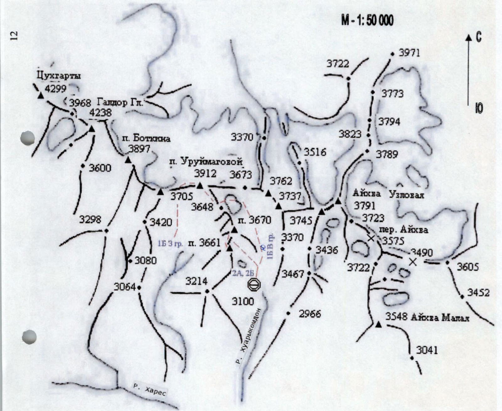
Area diagram: Galdor Gl. — Aikhva Uzlovaya.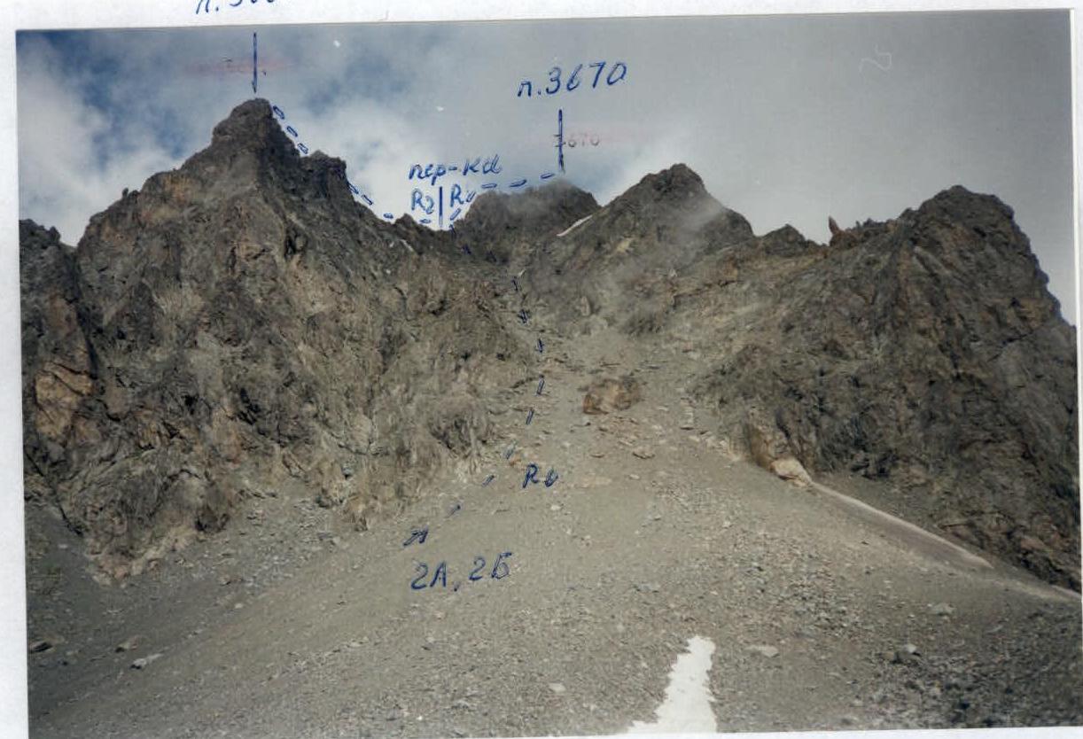
ROUTE DESCRIPTION
From the overnight stay, ascent up steep rises of moraine hills in the circus, sticking to its left part, in the direction towards the beginning of a wide scree couloir descending between peaks 3661 m and 3670 m — 1.5 h.
Further path goes:
- under cliffs along the left (in the direction of travel) side of the couloir to its middle part;
- then — transition to its central part;
- ascent up steep fine and medium scree with large stones;
- 50 m before reaching the saddle — turn right into a small convenient niche for belay, located between the wall and a large stone broken off from it.
Further:
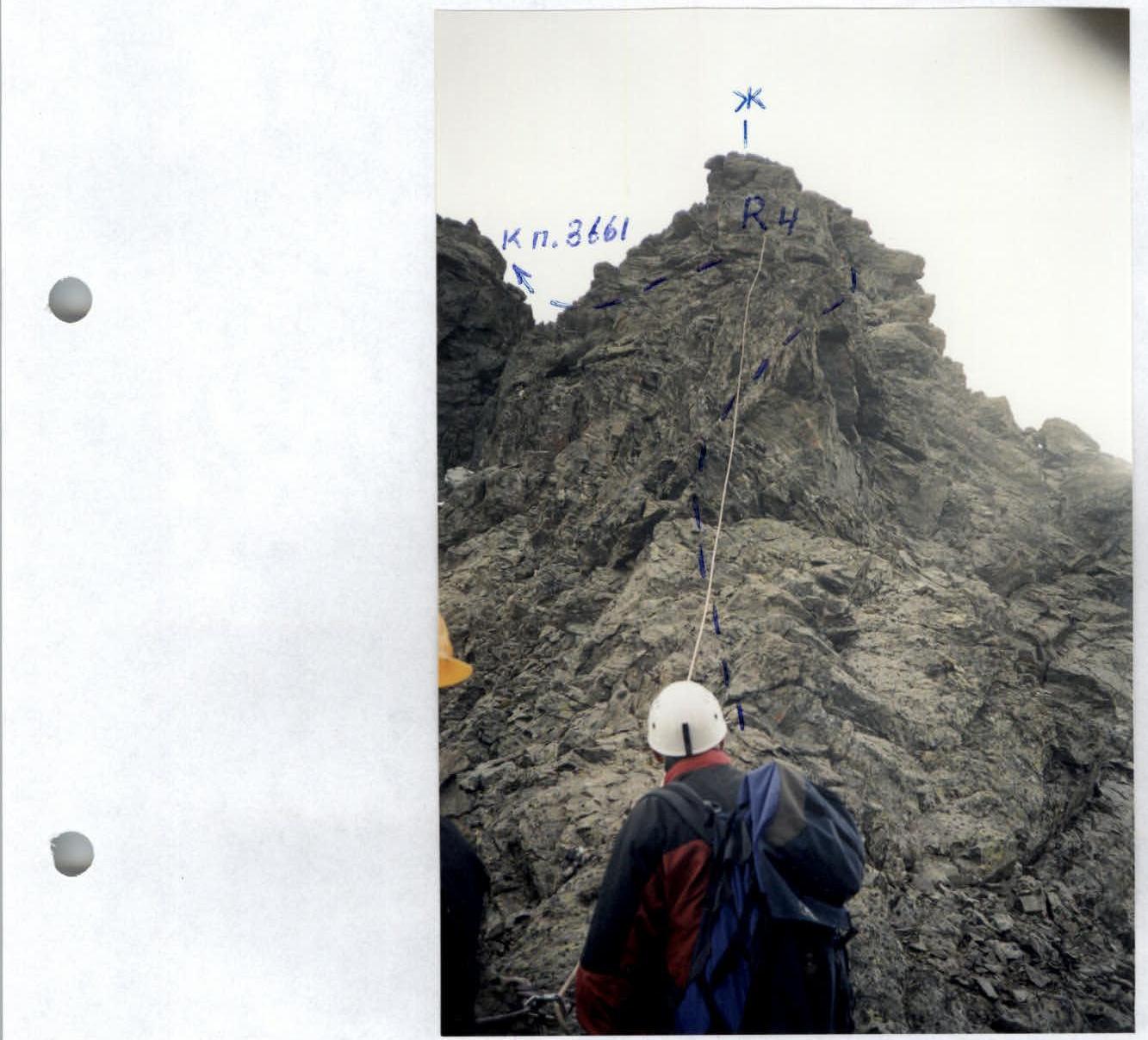
- ascent straight up 50 m on steep broken rocks to the saddle (belays through ledges, ropes).
Turning left, bypass the ridge gendarmes on the right along broken rock shelves with an exit back to the ridge under the wall. Ascent straight up 35 m on the wall (good holds), then transition to the right 5 m along the shelf under the wall, followed by ascent to the top of the wall onto a wide shelf. From here, movement to the left along the wide shelf (belays through ledges), bypassing ridge rocks with an exit to a small saddle in the ridge. Ascent to the summit follows broken rock shelves on the right side of the ridge.
From the overnight stay in the circus to the summit — 4–5 h.
p. 3661
View from the East. Taken from the circus (3300 m).
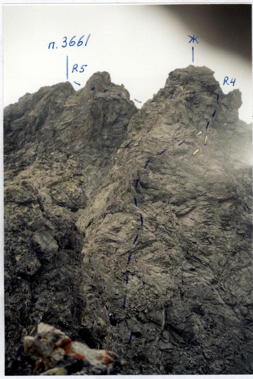
UIAA DIAGRAM
R0–R1 — 500 m; 40–45° — scree couloir. R1–R2 — 2nd cat. diff.; 50 m; 50° — broken rocks. R2–R3 — 2nd cat. diff.; 50 m; 30° — broken rock shelves. R3–R4 — 3–4 cat. diff.; 50 m; 50–60° — wall. R4–R5 — 2nd cat. diff.; 50 m — broken rock shelves.
DESCRIPTION OF THE APPROACH TO THE ROUTE
Bivouac is located in the lower part of the circus under the pass Zagadok. From AUSV "Digoria" move along the road to the waterfall — 1 h. Further, the road turns right — up, leading to the farm. 300 m before reaching the farm, descend to the right along the path to the river Aikhvadon. Having crossed it over stones, turn left, ascend straight up a gentle grassy slope to the beginning of a grassy ridge stretching north along the river. Reach the top of the ridge along a steep slope, wide at first, narrowing at the top, and overgrown with thick grass. Further movement along the top of the ridge follows an indistinct trail to a wide flattening.
At the top, the circus is visible on the left, located under the passes Uruimagovoy and Zagadok. The path to it goes from the flattening:
- with a smooth traverse to the left — up along a grassy gentle slope in the direction of the river Khuarykomdon,
- then — along it straight up grassy rises leading to the lower part of the circus. Near a large rusty stone — good areas for a tent, 40 m below under stones a stream flows. At the point of its emergence to the surface, a cairn is installed.
From AUSV "Digoria" to the overnight stay, the approach takes 5–6 h.
View from NE. Taken from the circus (3350 m).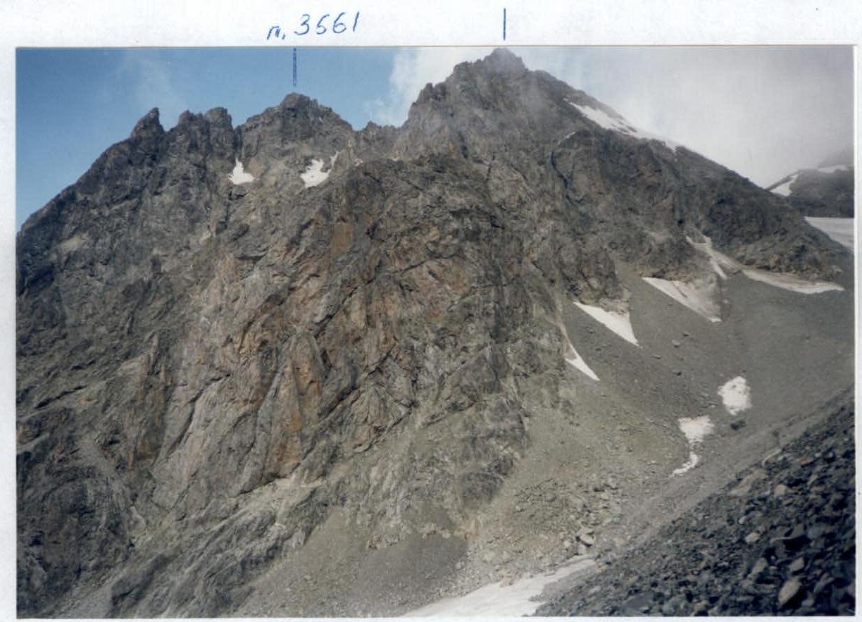
 R3
R3