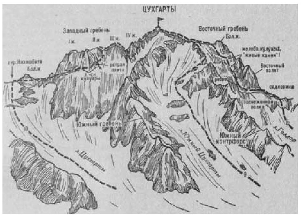
Fig. 4
- Tsukhgarty via Western Ridge (combined route by I. Suzhaev, category 4A difficulty, Fig. 4).
From the "Nakhashbita" meadow (group of 4–6 people) ascend via grassy slopes and then moraines to the right and upwards (northeast) towards the areas near a small lake below the Tsukhgarty glacier, beneath the Sugansky Ridge saddle, which connects the Nakhashbita peak on the left and Tsukhgarty on the right. The journey from the "Nakhashbita" meadow takes 1 hour 15 minutes.
From the lake, ascend the steep slope (possible rockfall — belaying required) of the Tsukhgarty glacier:
- approach a small icefall, which is bypassed on the right side closer to the rocks of Tsukhgarty peak
- after the icefall, ascend the narrow glacier (exposed to rockfall from Nakhashbita and Tsukhgarty slopes) in the direction of the snowy slope of the couloir descending from Nakhashbita pass, located between its large gendarme and the Main Nakhashbita peak — on the left
The journey from the lake takes 2–2.5 hours.
From the glacier, overcome the bergschrund via a snow bridge (belaying required) and continue ascending, sticking to the right side of the ice-snow couloir (possible rockfall) or the destroyed rocks on its right side (belaying required). In the middle part of the couloir, exit onto the ridge and then ascend an 70–80-meter slope (pitons belay) to reach the Sugansky Ridge saddle to the left of the Big Gendarme.
Ascent time:
- From the glacier: 3.5–4 hours
- From the "Nakhashbita" meadow: 6–7 hours
At the saddle near a small lake is the starting bivouac.
From the bivouac, turn right and via simple rocks alternating with snowy sections of a gently sloping slope, bypass the Big Gendarme of the saddle on the right. Behind it, along a sharp 60-meter ridge, reach a small saddle. Via simple but steep ridge rocks, descend 20 meters to the saddle, and then ascend a steep short edge to a standalone rock under the rocky ascent of the Western ridge of Tsukhgarty peak. Bypass the rock on the right and exit under the rocky ascent of the I gendarme of Tsukhgarty's Western ridge.
From under the ascent, traverse 60–80 meters to the right via rocks of above average difficulty and occasionally very narrow ledges with overhanging rock sections (pitons belay). Then, via steep rocks of average difficulty, reach a steep ice-snow couloir, which is traversed 45 meters to the right to exit onto a rocky edge. Having passed the edge via slabs with a small number of cracks, ascend via a traverse across simple and average difficulty rocks to the second ice-snow couloir with a protruding sharp slab in its middle.
Cross the second couloir above the slab. Initially on its right side, and then via rocks of average, occasionally above average difficulty, ascend to the II gendarme of the Western ridge.
From it:
- via simple and average difficulty destroyed rocks of the ridge,
- overcome a small gendarme on the saddle head-on to exit under the III gendarme.
From the saddle, via steep average difficulty slabs on the right side of the ridge, ascend 50 meters to the III gendarme.
From the gendarme, via simple rocks, descend 70–80 meters to the saddle of the Western ridge under the IV gendarme.
From under the IV gendarme, descend via an 80–90-meter rappel to the right. Then, via a traverse across rocks of average difficulty on the right slope of the Western ridge, through numerous narrow ice-snow couloirs and slopes, exit to a wide ice-snow slope — a couloir, which is used to ascend to the Western ridge.
Further, via simple and average difficulty, occasionally snow-covered rocks of the Western ridge with small gendarmes, which are easily overcome head-on or bypassed (bivouacs possible), ascend to the summit of Tsukhgarty. The journey from the bivouac on Tsukhgarty pass takes 8–10 hours.
Descent is via the Eastern ridge and Southern counter- slope (refer to route 9). Naumov A. F. Karaugom, Digoria, Tsey (Central Caucasus), M., "Fizkultura i sport", 1976.