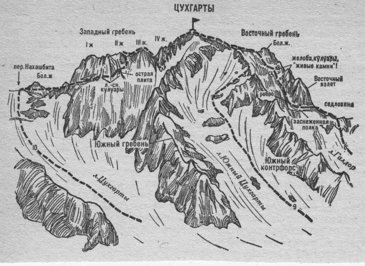
- Tsukhgarty via the Southern Counterfort and Eastern Ridge (combined route, 2A cat. dif., Fig. 2, 4). From the “Nakhashbita” meadow (group of 4–8 people) upwards to the left (north-east) along grassy slopes, then scree to the Southern Tsukhgarty glacier, which flows down from the Tsukhgarty massif between its Southern Ridge and Southern Counterfort.
From here, straight up the snow slope with simple rock outcrops (protection) of the Southern Tsukhgarty glacier. In the upper part of the glacier, where it widens, turn right and:
- via simple rock outcrops, alternating with ice and snow slopes (protection)
- then via simple rocks and scree ascend to the Southern Counterfort.
Here, turn left and via simple rocks and scree of the long Southern Counterfort ascend to the Eastern vertebral ridge of Tsukhgarty. Further, move left, along simple rocks of the Eastern Ridge approach a small gendarme and overcome it via simple rocks of the Ridge (can be circumvented on the right). Behind it, via simple rocks of the Eastern Ridge ascend to the summit of Tsukhgarty.
Movement scheme:
- Ascend via scree and rocks of the Southern Counterfort to the Eastern vertebral ridge
- Movement left along simple rocks of the Eastern Ridge
- Overcoming a small gendarme (along the Ridge or bypass on the right)
- Continuation along the Eastern Ridge to the summit of Tsukhgarty
From the “Nakhashbita” meadow — 6–8 hours.
Descent along the ascend path.