Russian Mountaineering Championship 1997. Technical Climbing Category. Sugan-Bashi Peak (4450 m). Route: Right part of the Eastern wall — KTSHGV point 2.6.52. Climbed by the team of North Ossetian Republican Search and Rescue Service of the Ministry of Emergency Situations of Russia and the "Ossetia" mountaineering club.
Leader: Egorin Sergei Vladimirovich, CMS.
Coach: Korablin Boris Nikolaevich, MS USSR, Honored Coach of the RSFSR.
Year of ascent: 1997.
Address and phone number of the North Ossetian Republican Search and Rescue Service of the Ministry of Emergency Situations of Russia:
- 362035, RSO-Alania, Vladikavkaz
- Kostа Street—273; phone: 74-11-03
Coach Korablin Boris Nikolaevich's phone:
- St. Petersburg
- 246-05-19 (home)
Address and phone number of team leader Egorin Sergei Vladimirovich.
Address and phone number for report-related inquiries:
- 362019, RSO-Alania, Vladikavkaz
- Shmulevich Street—16, building 4, apt. 9; phone (home): 33-77-70; phone (work): 74-11-03
Ascent Passport
- Technical Climbing Category.
- Ascent area: Caucasus, Digoria, Sugan range.
- Peak, route: Sugan-Bashi (4450 m), right part of the Eastern wall.
- Category of difficulty: 6A, 6th ascent.
- Height difference: 930 m.
- wall section: 800 m.
- total route length: 1230 m.
- wall section length: 890 m.
- including:
- category 5: 360 m.
- category 6: 150 m.
- average steepness of the wall section: 60°
- average steepness of the route: 55°
- average steepness of key sections: 95°
- Pitons driven:
- rock: 67/11, ice: 12/0, chocks: 22/6, bolt pitons: 2/2.
- Climbing hours/days: 29 h/3.
- Overnight stops: 1st — on the plateau under the route after a day of processing, comfortable, lying down. 2nd — on a ledge below the second bastion, lying down.
- Leader: Egorin Sergei Vladimirovich, CMS. Participants: Afanasiev Igor Oleg-Slavyanovich, MS, Ivanov Vitaly Valentinovich, CMS.
- Coach: Korablin Boris Nikolaevich, MS, Honored Coach of the RSFSR.
- Approach start: August 26, 1997. Route start: August 28, 1997. Summit: August 30, 1997. Return: August 31, 1997.
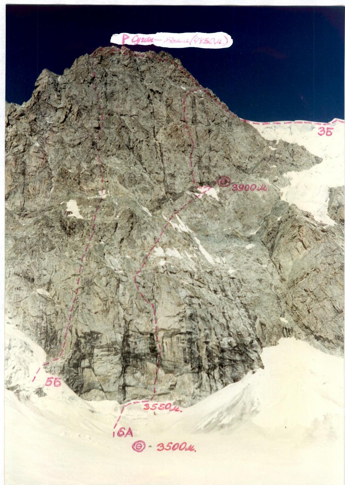
General view of Sugan-Bashi peak (4450 m). The route on the left part of the Eastern wall, category 5B, is marked on the left. In the center is the route climbed by the SORSRS team. On the right is the route via the North-Eastern ridge, category 3B. Photo taken from the plateau under the route, end of August, 11:00, altitude 3500 m. Distance to the wall is about 800 m. T-43 lens, focal length 40 mm. Shot point number 1.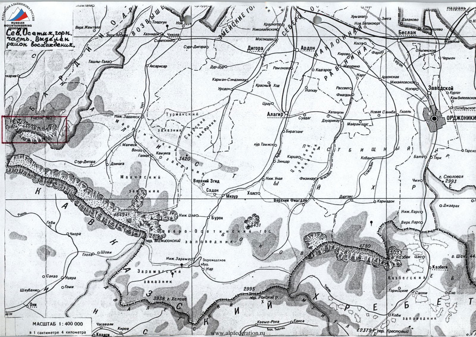
Scale 1:400 000, 1 cm — 4 km.
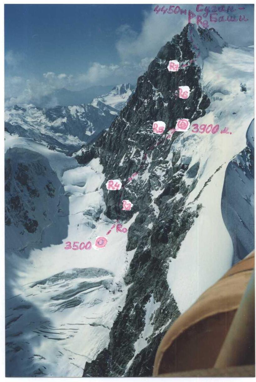
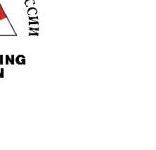
Right wall profile, end of August. Photo taken from a helicopter, altitude about 4000 m. Noon, distance to the peak about 1000 m. T-43 lens, focal length 40 mm.
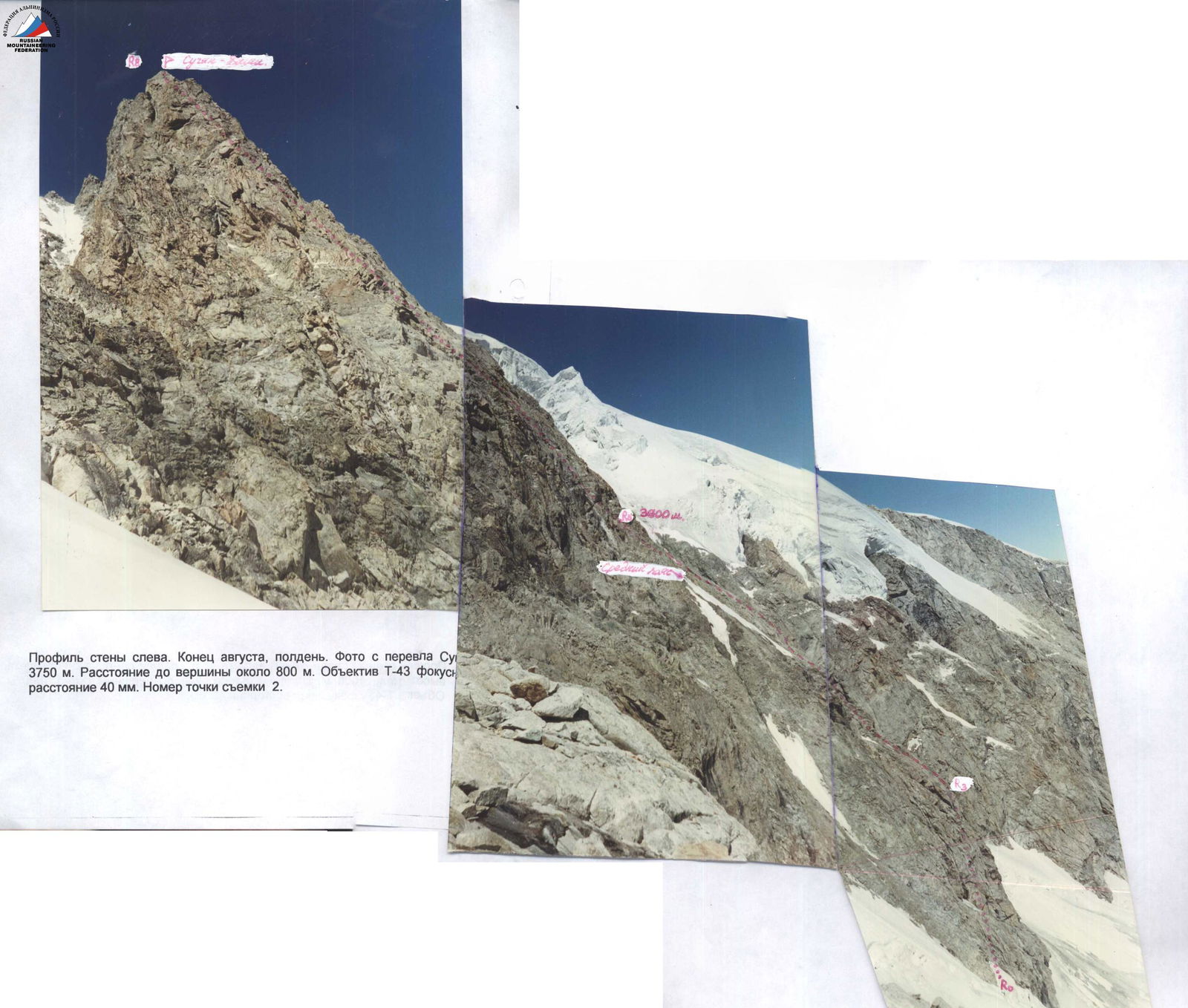
Left wall profile. End of August, noon. Photo taken from Suan pass 3750 m. Distance to the peak about 800 m. T-43 lens, focal length 40 mm. Shot point number 2.
Classified
Coordinate system 1942.
Area photopanorama. View from the north. End of August, photo taken from a helicopter. Altitude 4300 m. Noon, distance to the peak about 3 km. T-43 lens, focal length 40 mm.
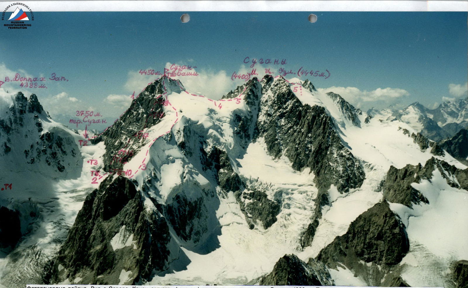
Marked routes:
- Number 1: route to Sugan-Bashi peak, category 5A, via the South-Eastern ridge.
- Number 2: route climbed by the SORSRS team.
- Number 3: route via the North-Eastern ridge, category 3B.
- Number 4: North-Western ridge, category 3B.
- Number 5: Traverse of Sugans (Maly — Centralny — Uzlovoy), category 5A.
Brief Overview of the Ascent Area
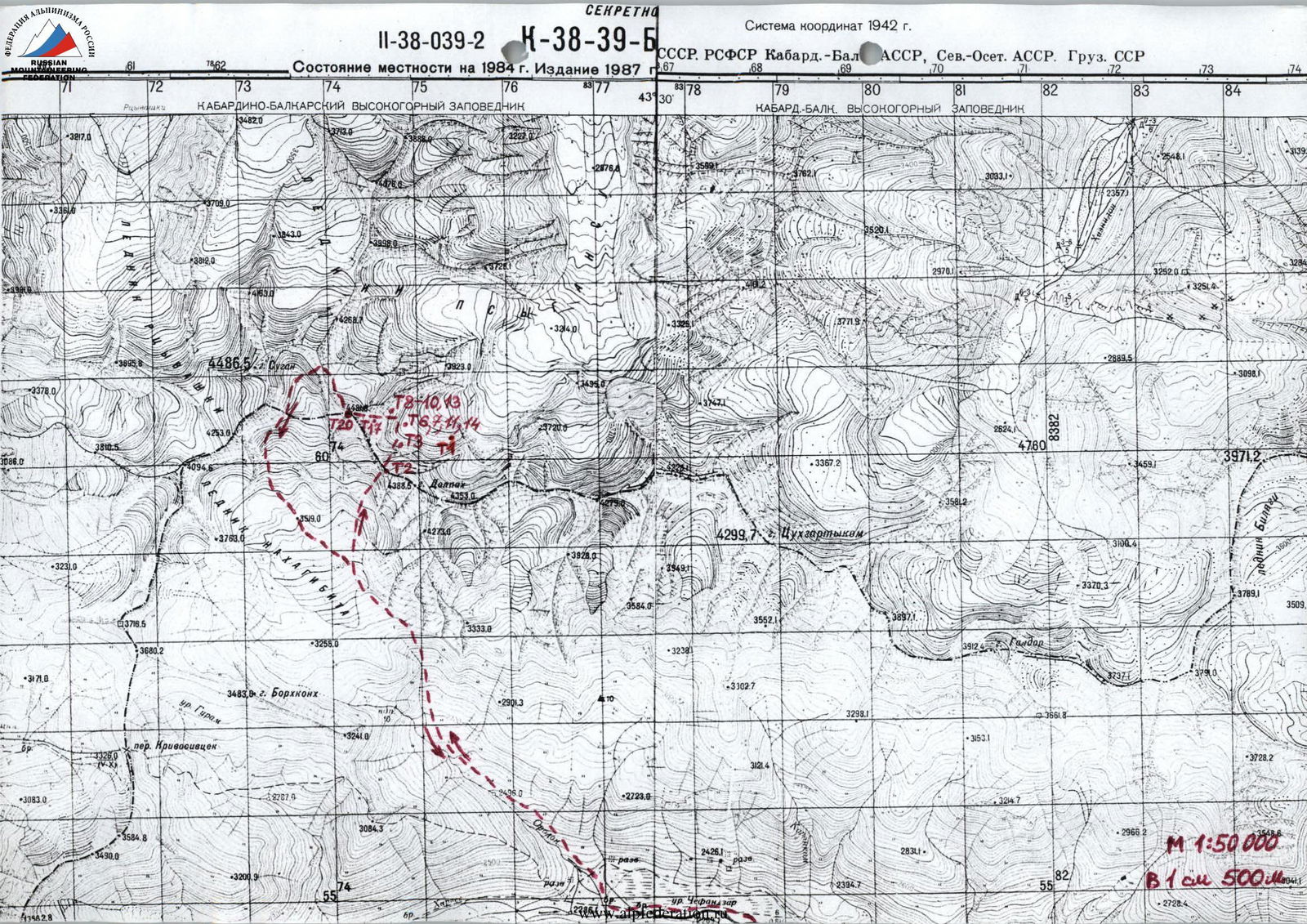
Sugan-Bashi peak (4450 m) is located in the center of the Sugan range. The southern slopes of the Sugan range are situated on the territory of the Republic of North Ossetia-Alania. The northern slopes are on the territory of the Kabardino-Balkar Republic. The Sugan range is located between the basins of the Cherek-Balkarsky river to the west and the Urukh river to the east. Numerous rivers flow from its slopes: Rtsyvaashki, Psiganisu, Khazhdon, Belyagidon, Karasu, Khares.
The Sugan range stretches for almost forty kilometers in the latitudinal direction. It reaches an average height of 3800 meters. Its highest peaks, reaching about 4500 m, rise 1000 meters above the snow line. All its passes, even the lowest and relatively accessible ones, are located above 3300 meters, and in the central part of the massif — above 3700 meters.
The Sugan range is composed of ancient rocks: light gray granites of the Paleozoic and dense, highly metamorphosed clay shales of the Lower Mesozoic. The range has an asymmetric structure of its slopes: steep and short to the south, gentle and long to the north. The southern slopes are composed of numerous destroyed ridges and counterforts, between which are steep, heavily torn, short hanging glaciers; below them are numerous scree slopes. The southern slopes are well освоened by mountaineers, who have laid dozens of routes here from category 1B to 5B.
The northern slopes are characterized by:
- large glaciation
- rare rocky ridges
- a larger height difference compared to the south.
Ascents from the north are technically complex and harsher in terms of weather conditions. The routes climbed have fourth and fifth categories of difficulty, and most are still waiting for their first ascenders.
The climate of the area can be characterized as mountainous, cold, with high humidity (1500–1600 mm of precipitation per year).
Summer in the mountains (July–August) is short and cold (+14…+16 °C).
Winter lasts from November to March, and in the highlands, there can be frosts down to –30 °C, but relatively little precipitation falls. Most of it occurs from May to August.
From an altitude of 3200–3500 m, the climate is eternal cold, reminiscent in its severity of the Arctic climate:
- The average temperature even of the warmest month does not rise above 0 °C;
- Cloudy, windy weather prevails;
- A large amount of precipitation, mostly in the form of snow.
Brief Description of the Approach to the Route
From Vladikavkaz to the "Digoria" Huts by car takes about 3 hours.
Further up the Khares river valley, along the old road to the waterfall on the left orographic slope of the valley — 1 hour. Then ascend along the same side of the valley up the trail through the narzan (you need to follow the lower one) to the Galdoridon river, which is crossed by stones (another 1 hour).
Continue moving west, walking along the boggy bank of the Khares river, crossing the stream flowing from the Nakhashbita meadow. From the Galdoridon river to this point takes about 40 minutes.
Then ascend along the right (in the direction of travel) board of the Orsdon river valley towards the visible waterfall on the left. By-passing the waterfall and the "ram's foreheads" via scree slopes, exit left onto the moraine (to the Sugan overnight camps) — another about 2.5 hours. It is advisable to spend the night here.
The next day, start early in the morning, and first along the moraine, then along the Doppakh glacier, move north towards the pass visible ahead between the peaks: Sugan-Bashi on the left, Doppakh Western on the right. This is the Suan pass (350 m, category 3A). After crossing the glacier, ascend the steep southern snow-ice slopes of the pass. Cross bergschrunds and crevasses via snow bridges with insurance. Be cautious of falling rocks from above! Above the middle part of this steep slope, turn right onto destroyed rocks. Ascend via ledges directly upwards, below the Western wall of Doppakh Western, via rocks of categories 2–3, beware of loose rocks! Insure using ledges and pitons driven into the wall on the right. The pass ascent is a narrow ice couloir up to 45°, about 100 m long. Reach the snow-scree saddle of the Suan pass. From the overnight camps, it takes about 5 hours.
Descent down a steep ice slope (up to 50°) directly from the pass — 50 m. Then down a snowy slope. Cross crevasses via snow bridges. Exit onto a plateau (3500 m) under the Eastern wall of Sugan-Bashi. From the pass, it takes another 1 hour.
The approach takes two days.
Alternative approach:
- from the village of Verkhnyaya Balkaria
- in the Cherek-Balkarsky river valley
- via the Kurnoyat pass (2100 m)
- cross into the Psiganisu river valley
- ascend the valley
- exit onto the Nakhashbita glacier
- approach the wall via the glacier
This alternative approach also takes two days.
Preparation for the Ascent
Before the ascent, reconnaissance trips were made under the route and to the area of the future ascent. Available topographic maps of the massif were studied. This determined the route's orientation and identified the most logical and safe path. The climate of the area was studied to plan the ascent during safe, good weather. Principles of radio communication on the route were clarified; it was decided to use Japanese VHF radio stations. With their help, stable communication was maintained throughout the route with the North Ossetian Republican Search and Rescue Service in Vladikavkaz, where a team of professional rescuers is always on duty. Available literary and local history materials on the ascent area were also studied. Interviews were conducted with people who had been in the ascent area and knew the approach paths. Relevant mountaineering and tourist literature on the area was studied (books, reports).
Maps available at the North Ossetian Republican Search and Rescue Service were used, scale 1:50 000 (1 cm — 500 m), corrected using aerial photographs in 1987. These topographic maps are still classified as "for official use". The map diagram provided in the report was copied from these topographic maps.
The team became familiar with the ascent object back in the early 1990s when they made ascents to the 2nd and 1st discharge levels. Most participants of the current ascent had then climbed category 5A on Sugan-Bashi via the South-Eastern rib. The approach path under the wall via the Suan pass was also known to them. The descent path from the ridge between Sugan-Bashi and Sugan Maly via three hanging rappels to the south, onto the Doppakh glacier, was traversed twice. Photography of the peak and wall was partially done from a helicopter during search operations last year.
Before the ascent, the team made several training ascents in the Sugan range and in their own area. The team regularly went on rock and ice training sessions in Karmadon.
The tactical plan for the ascent was developed after familiarizing themselves with the route description. Since the lower part of the wall is key to the route and there is nowhere to spend the night there, it was decided to process it. For this, it was planned to take three ropes.
The lower part of the wall was planned to be ascended in the same manner as previous teams:
- up to the second control tour on artificial aids,
- above — free climbing.
Two pairs of étriers were prepared for movement on artificial aids:
- for the first,
- for the second, straightening the ropes.
For better insurance on cornices, it was decided to take "Petzl" brand bolt pitons. For the climber ascending via free climbing — rock shoes.
Given the unstable weather in the area at this time, with possible bad weather days, food and fuel were taken with a reserve for a sit-in. To accurately determine altitudes, an altimeter was taken.
Ascent Schedule
The ascent schedule displays altitude and time of day relative to the days of ascent.
- On the vertical axis "Time of day" from 6 to 18.
- On the horizontal axis "Days of ascent": 1st day (August 28) and 3rd day (August 30).
- On the 1st day (August 28) at 3500 m — overnight stop on the plateau under the route, lying down, clear.
- On the 3rd day (August 30) at 3900 m — overnight stop under the 2nd bastion, lying down, variable cloudiness.
- Sugan-Bashi peak (4450 m) reached on the 3rd day (August 30) with variable cloudiness and strong wind.
- Route sections have a steepness of 60°.
Team's Tactical Actions
The ascent was made without deviations from the tactical plan in terms of time and overnight stops.
It was planned to process the lower part of the first bastion on the first day, slightly above the second control tour. Everything went according to plan on the day of processing.
On the second day, as previously planned:
- Climbed the processed part of the wall.
- Ascended under the second bastion.
- Processed it over three ropes.
On the third day, in accordance with the tactical plan:
- Climbed the second bastion.
- Reached the summit towards the evening.
On the route, due to the complex relief and high difficulty of the rocks, the first climber almost always moved without a backpack or, at least, lightly loaded. When moving via free climbing, the first climber wore rock shoes. When ascending the processed sections of the first bastion, backpacks were pulled up. Higher, when ascending via fixed ropes, backpacks were either carried on the back or suspended underneath using the "American method".
The ropes used were all French with a UIAA quality certificate (44 mm). Climbing devices used were also of high quality: "Petzl" brand.
Mostly, due to the significant steepness of the rocks, two jumar ascenders were used when climbing via fixed ropes. Insurance for the lead climber was through an "eight" and in leather gloves.
Attachment points:
- Ropes.
- Lead climber's insurance.
- Second climber's insurance.
- Self-insurance. — were always separate.
A station consisted of four to five points (pitons, chocks) or was anchored on two to three bolt pitons (first bastion).
When ascending via the North-Eastern ridge, category 3B:
- For lead climber's insurance.
- For organizing stations. — ice screws were used.
For work on the route, they tried to use the entire daylight period. Woke up at 3–4 am, prepared breakfast, and started moving at dawn. Became stationary for the night 2 hours before dark (on the day of processing), and 1 hour before dark (after the summit).
During the overnight stop on the wall, the tent was set up at noon; thus, there was ample time to prepare the site and cook food. All overnight stops were comfortable, lying down, and in safe locations:
- First — on the plateau under the first bastion,
- Second — at the start of the second bastion under an overhanging rock,
- After the summit — on the ridge in the saddle between Sugan-Bashi and Sugan Maly.
During the ascent, they did not stop for lunch: each had a pocket snack. Hot drinks and food were consumed in the morning and evening. The entire route was climbed without injuries or falls.
To solve key sections of the route, all planned equipment was used:
- Bolt pitons (2 pcs. driven),
- Étriers with ladders,
- Rock shoes, etc.
The ascent demonstrated the team's significant physical and technical capabilities; there were no injuries or falls, the tactical plan was followed and fully executed, and the team descended from the summit with a substantial reserve of strength.
During the ascent and approaches, there was constant communication with Vladikavkaz, with the North Ossetian Republican Search and Rescue Service, where a team of professional rescuers is always on duty. A Japanese-made VHF radio station was used. All altitudes were determined using an altimeter.
 www.alpfederation.ru↗
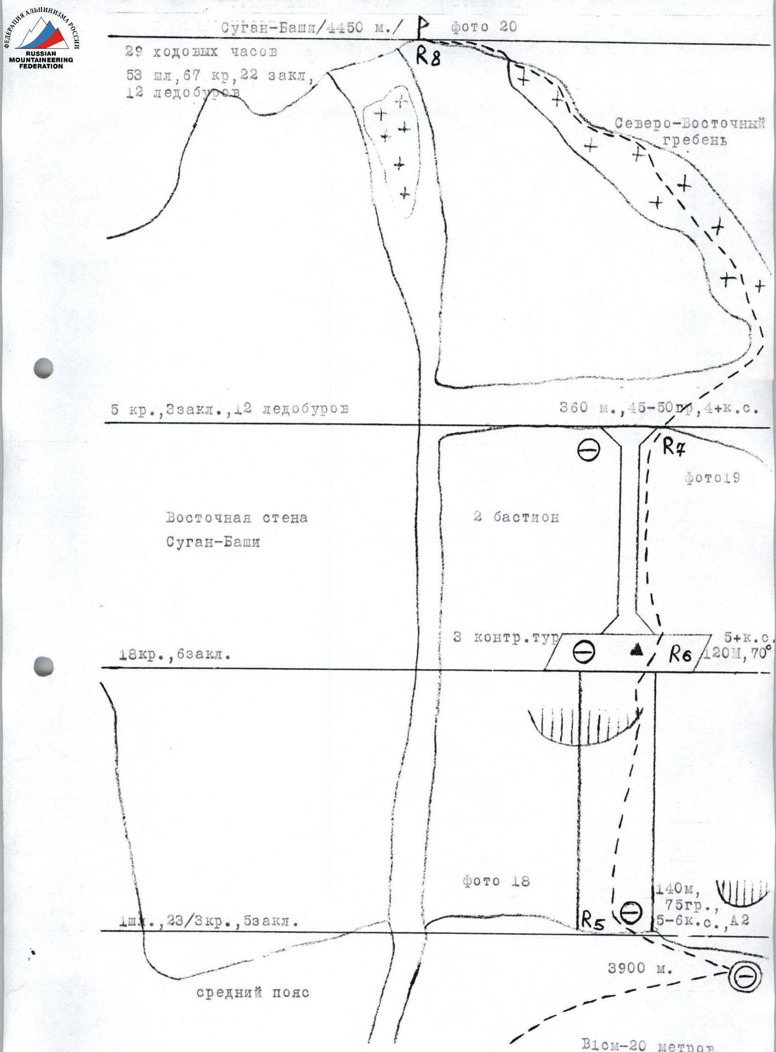 www.alpfederation.ru↗
Route Description by Sections
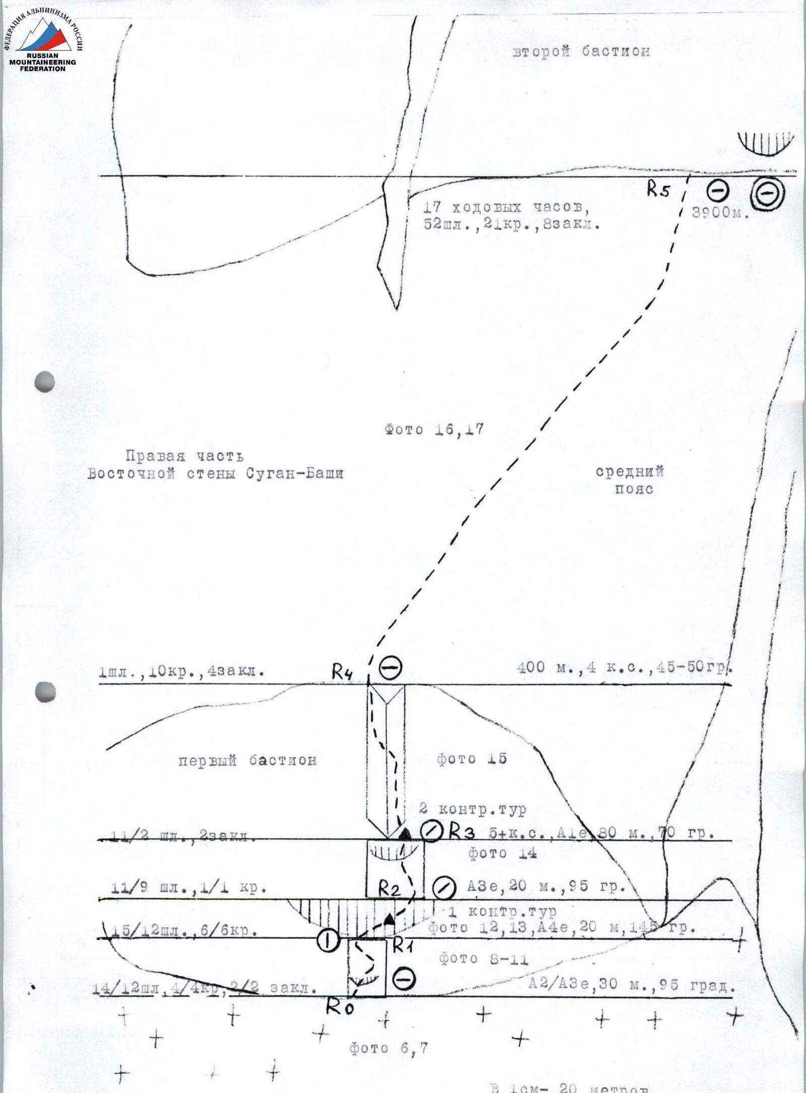
From the overnight camps on the plateau under the Eastern wall of Sugan-Bashi, approach through the bergschrund (via a snow plug, crampons) under the waterfall to the start of the route.
Section R0–R1:
Find the start of the ascent via driven pitons. Ascend upwards using artificial aids, utilizing driven bolt pitons and own pitons. After passing through the first small overhang, ascend under a large cornice with black streaks.
- A2/A3e, 30 m, 95°.
- Monolithic rocks.
Section R1–R2:
Along the cornice ceiling, using driven bolt pitons for artificial aids and insurance, exit beyond the cornice onto an uncomfortable ledge.
- A4e, 20 m, 145°.
Beyond the cornice bend:
- observation of the partner is difficult;
- for straightening the ropes for the second climber, étriers (ladders) are also desirable;
- on the cornice bend, in a tin can — 1st control tour.
From section R2 down — vertical fixed ropes 50 m.
Section R2–R3:
Up the wall towards the visible red triangular cornice. Through the cornice upwards onto a ledge.
- A3e, 20 m, 95°.
Up to this point, movement from the start of the route is entirely on artificial aids. Here, on the ledge — 2nd control tour. It is recommended to process the route up to this point.
Section R3–R4
From the control tour upwards along the right part of the inner corner. Water flows through the center of the corner, its intensity depends on the amount of snow on the middle belt. After 20–25 m, cross the inner corner and ascend along its left part. This section is mostly climbed via free climbing. The rocks are monolithic, pleasant for climbing. After 5–6 m, driven bolt pitons are encountered for insurance. At the end of the section, exit onto a scree ledge. Here is the end of the first bastion.
- 5+ category, A1e, 30 m, 70°.
- Time to reach here: 10–12 hours.
Section R4–R5
Ascend along the middle belt to the right and upwards towards the visible second bastion. The rocks are heavily destroyed. Organizing reliable insurance is problematic.
Features of the section:
- Frequent rockfalls occur in the upper part of the Eastern wall.
- The path of falling rocks is along a vertical gully-couloir that bisects the upper part of the wall.
- Section length: 400 m.
- Category: 4.
- Angle of inclination: 45–50°.
Section R5–R6:
Approach under the second bastion to the right of the gully-couloir. Overnight stop on a scree ledge under an overhanging rock. To the left of the overnight stop, ascend upwards along the wall of the second bastion. The rocks are tile-like, with many overhanging blocks; there are few cracks suitable for driving pitons. In the upper part of the section, ascend to the right of the overhanging rust-colored rocks. Pass the overhang using artificial aids, utilizing chocks and pitons. Above, exit onto a scree ledge, almost in the center of the second bastion.
- Section length: 140 m, 75°, 5–6 category, A2.
Section R6–R7
- On the ledge, our own control tour was left, as the 3rd control tour on the second bastion was not found.
- Continue from the ledge via destroyed rocks for 20 m, about category 4, then ascend upwards to the right of the overhanging ice-filled chimney.
- Ascend along the wall to the right and upwards towards the bend of the second bastion.
The entire section: 120 m, 70°, 5+ category, to the end of the second bastion — about 26 hours.
Section R7–R8:
- Beyond the bend of the second bastion, exit onto a belt of destroyed rocks.
- Along them, turn right onto the North-Eastern ridge of Sugan-Bashi (category 4B, organizing reliable insurance is difficult, live rocks!).
- Along the North-Eastern ridge, via the route of category 3B, ascend via ice up to 45° to the summit of Sugan-Bashi (4450 m).
The entire section: 45–50°, about 360 m, 4+ category. Took 3 hours.
From the summit, descend along the North-Western ridge, category 3B. Upon reaching the ridge between Sugan-Bashi and Sugan Maly, descend to the south via three 50 m rappels onto the Doppakh glacier. From there, to the Sugan overnight camps.
Supplement
We believe that our passage of the route is the sixth. Since the last team on the route — K. Khamitsaev's team (February 1995) — did not complete the route fully. This can be judged by the rappel loops on the first bastion — at the top of the large cornice and on the second control tour. The rope from which these loops are made, cut with an axe, is from the Everest expedition in 1995, in which all three of us participated and know well that no one else had such a rope before. The fact that they did not climb above the second control tour is also indicated by the fact that, despite our requests, no one from their team showed us photos of the route. They also said they did not find a note on the summit but left their own. We, when we reached the summit, quickly found a note from the summer of 1996, left by a group that had removed the note from 1993 (the note is attached to the report). So, we believe the route was not fully climbed for at least four years.
Recommendations for the route: it is better to take 50 m ropes. The first bastion must be processed, at least up to the second control tour. After processing, it's necessary to start as early as possible, as rockfalls start very quickly after the second bastion due to the wall's exposure, and the middle belt is heavily affected.
It's also necessary to have "Petzl" brand bolt piton ears, as they are threaded. About 10 pitons were driven by us and K. Khamitsaev's team on the first bastion. The eyes (speleo-pitons, also called "spits") have been unscrewed.
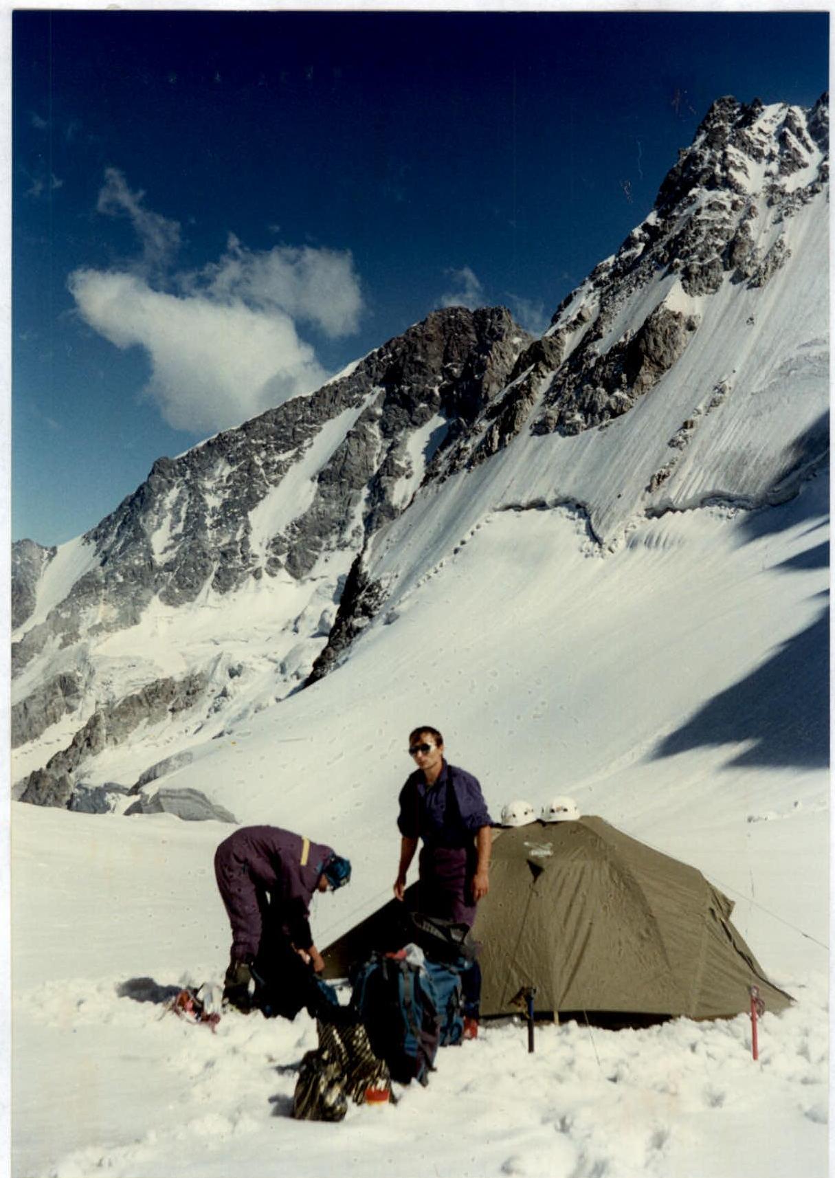
Photo #6. Overnight stop on the plateau at 3500 m. Under the route. Nakhashbita peak is visible in the distance. August 27, 1997, 16:00.
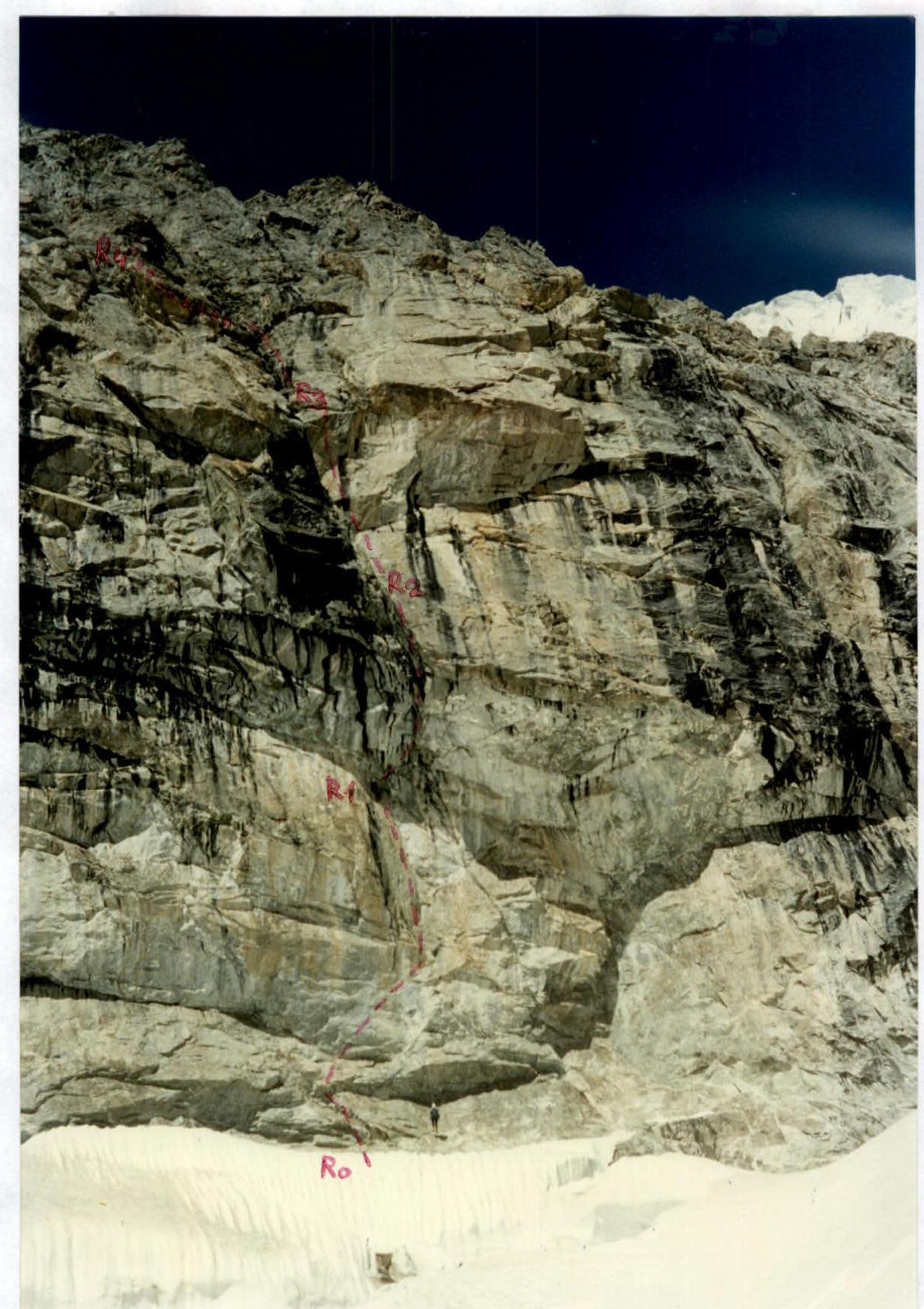
Photo #7. First bastion. View from the plateau (route marked). August 28, 1997, 11:00.
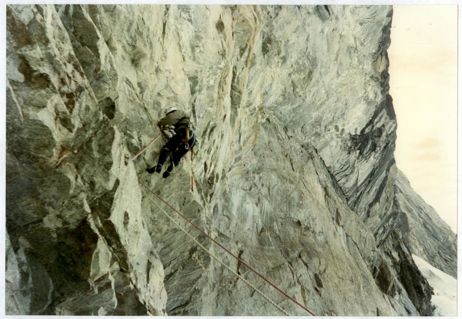
Photo #8. Climbing the first overhang on section R0–R1. Lower part of the section. Photo taken from R0. August 28, 1997, 10:00.
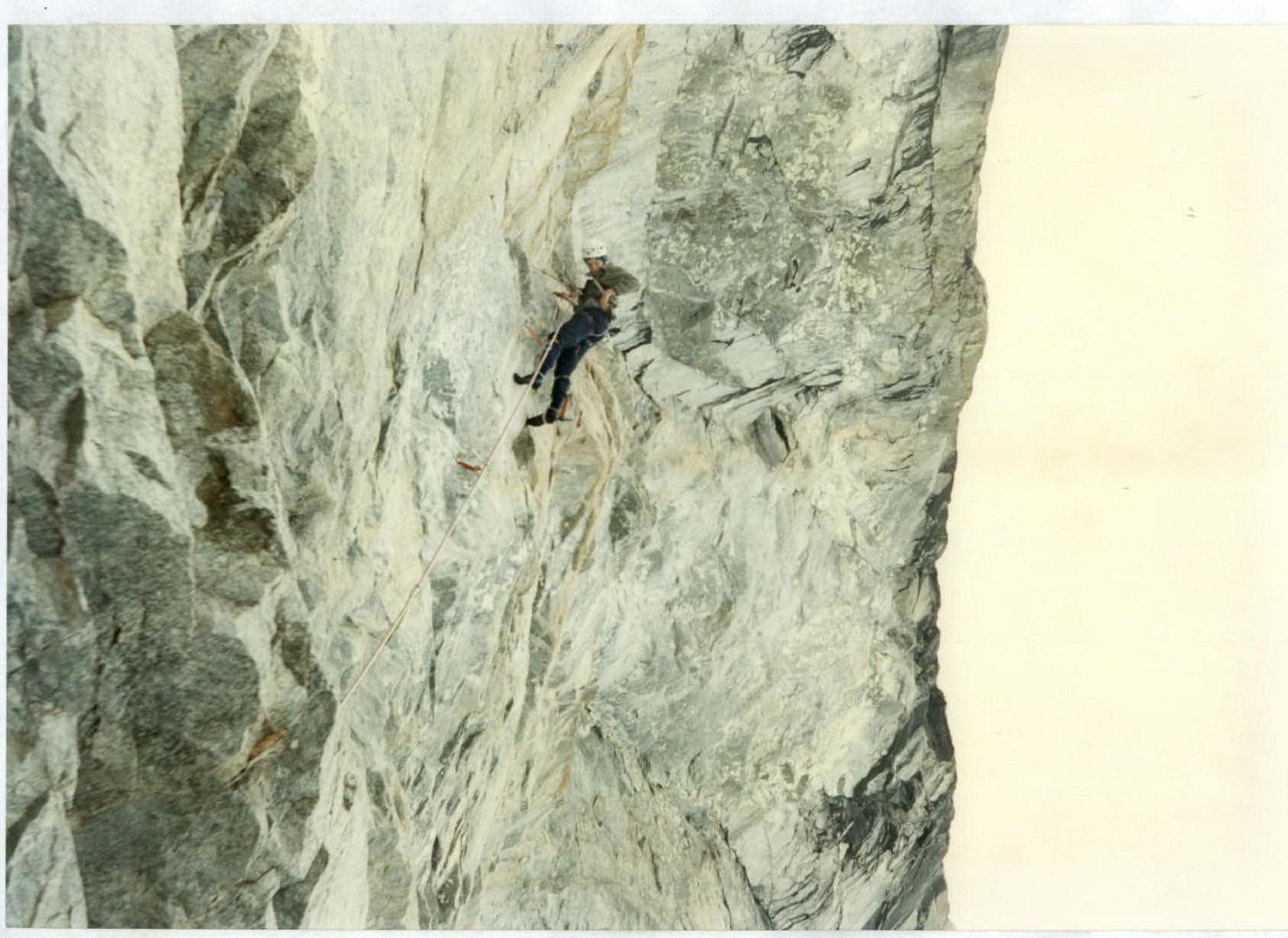
Photo #9. Climbing the middle part of section R0–R1. Photo taken from R0. August 28, 1997, 10:30.
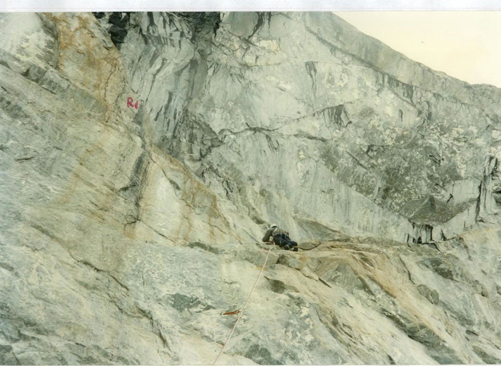
Photo #10. Climbing the upper part of section R0–R1. Photo taken from R0. August 28, 1997, 11:00.
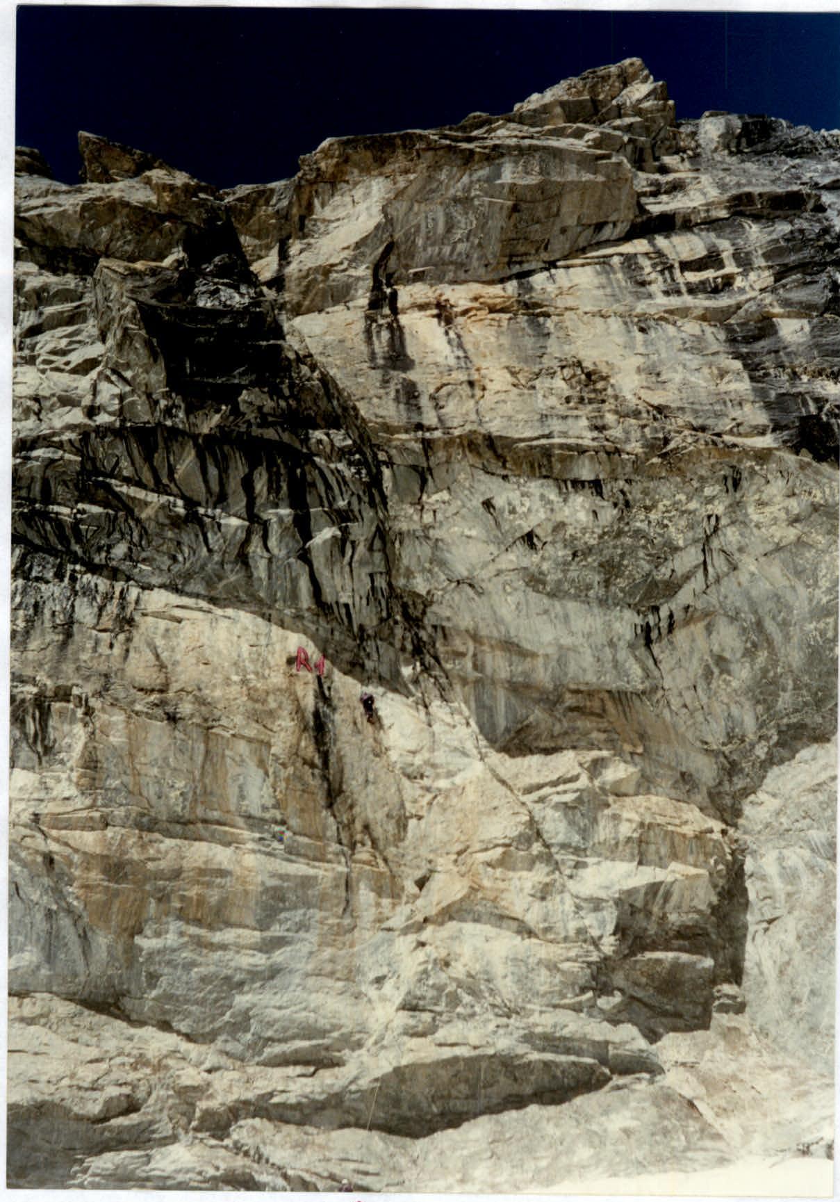
Photo #11. Climbing the upper part of section R0–R1. Photo taken from the plateau. August 28, 1997, 11:15.
Photo #12. Movement along the cornice ceiling on section R1–R2. Photo taken from R1. August 28, 1997, 13:30.
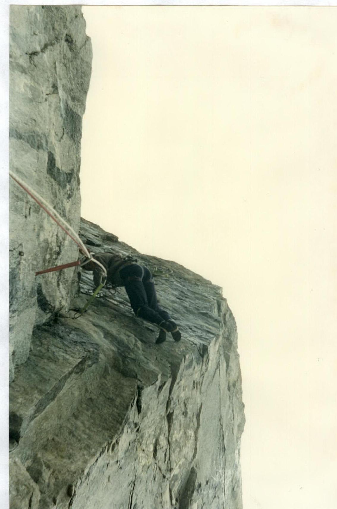
Photo #13. Ascent via fixed ropes on section R0–R2. Photo taken from R0. The R1–R2 cornice is visible in the center, Doppakh Western peak in the background. August 29, 1997, 6:30.
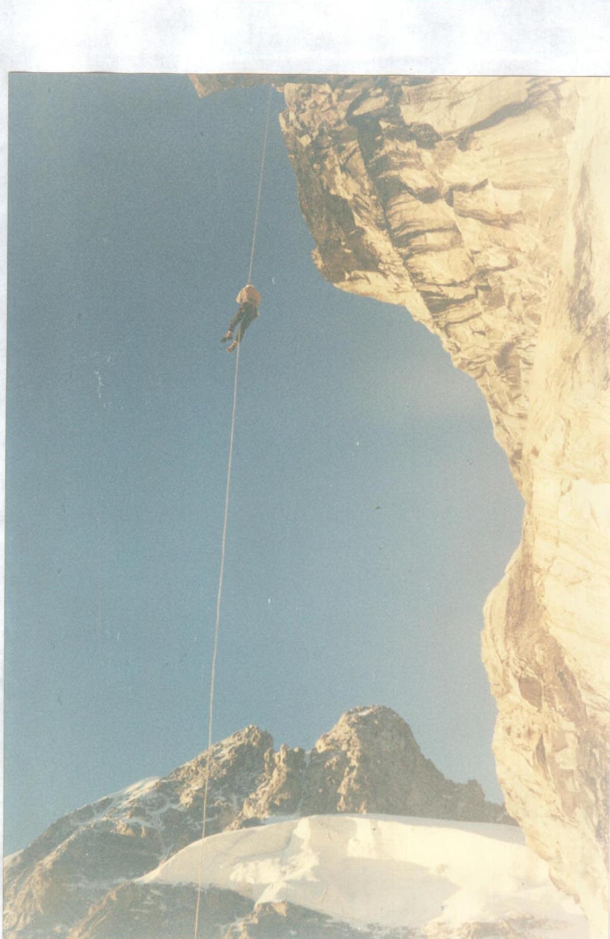
Photo #14. Climbing section R2–R3. Photo taken from the plateau. August 28, 1997, 15:00.

Photo #15. Upper part of the first bastion. Section R3–R4. Photo taken from the middle of the section. August 29, 1997, 11:00.
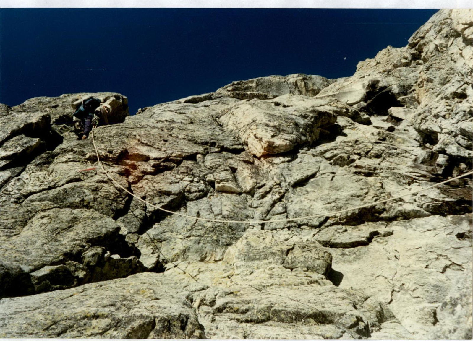
Photo #16. Climbing the start of section R4–R5. Photo taken from R4. The second bastion is visible in the distance. August 29, 1997, 12:00.
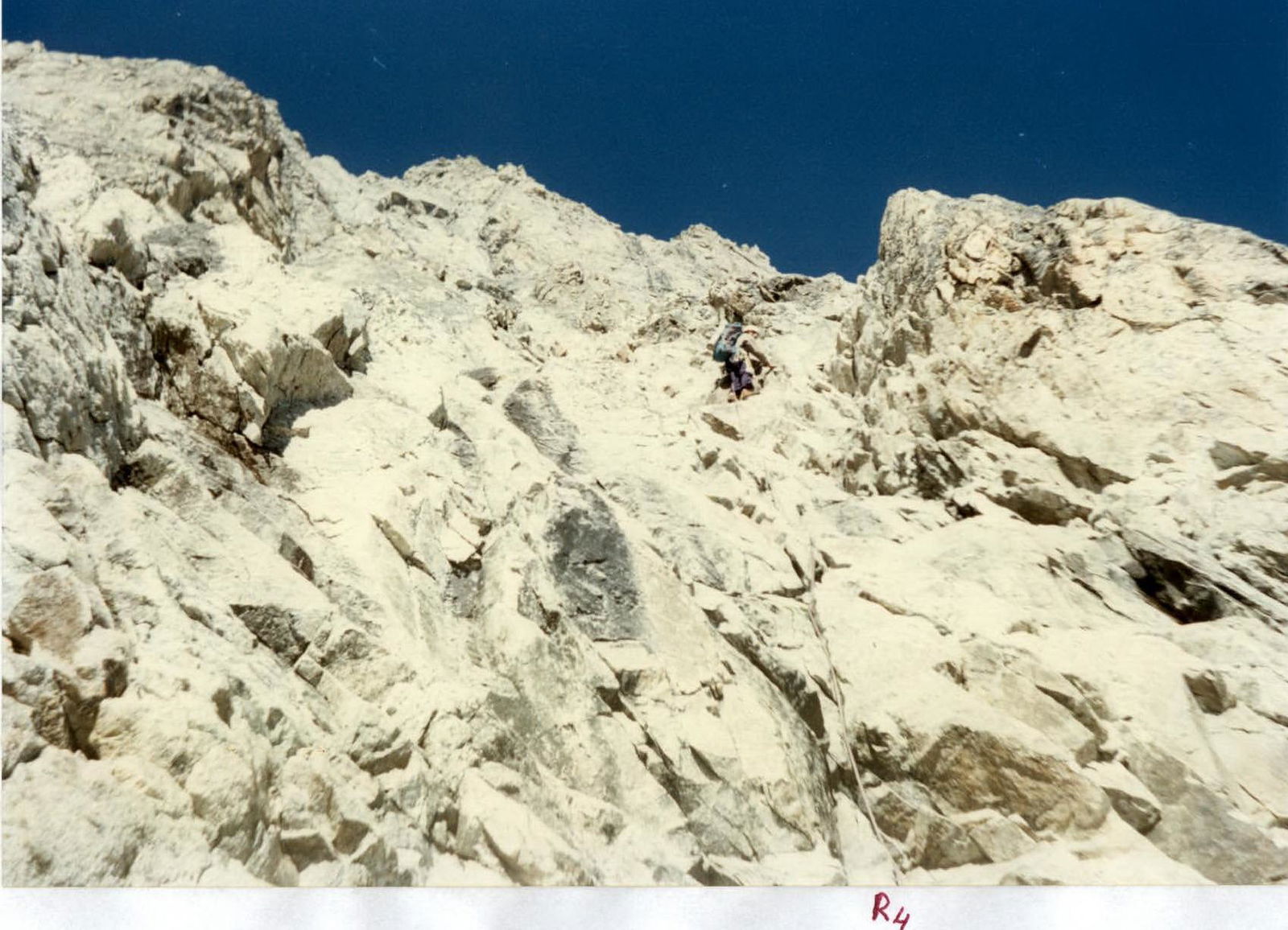
Photo #17. Climbing the upper part of section R4–R5. Photo taken from the upper part of section R4–R5. The second bastion is visible on the right in the foreground. August 29, 1997, 13:30.
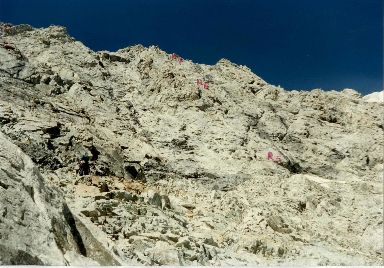
Photo #18. Climbing the upper part of section R5–R6 (above the overhang). Photo taken from the upper part of section R5–R6. August 30, 1997, 11:00.
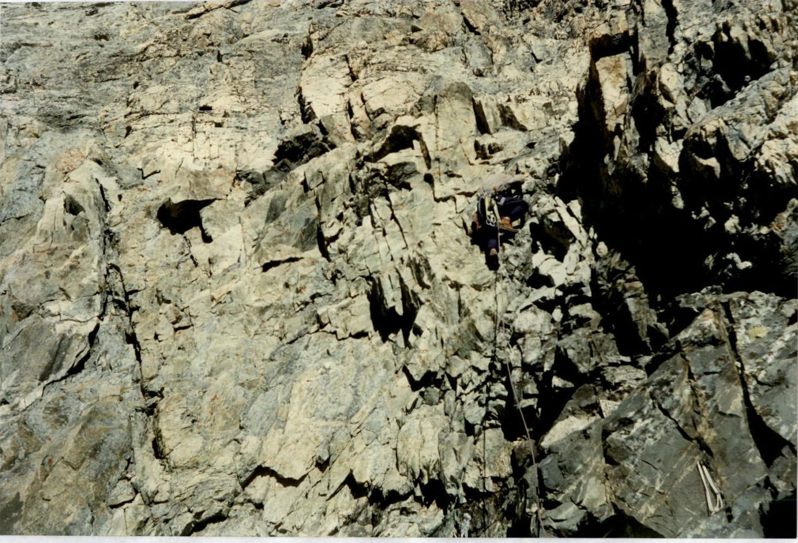
Photo #19. Climbing the upper part of section R6–R7. Photo taken from the upper part of section R6–R7. August 30, 1997, 14:30.
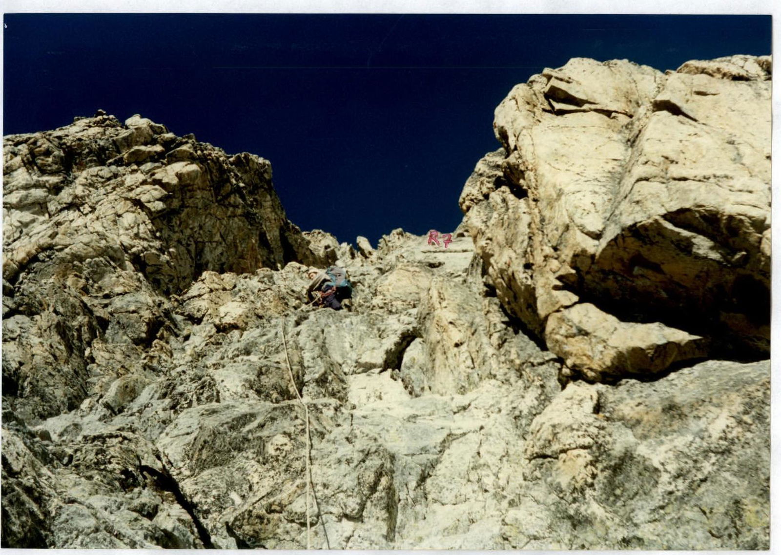
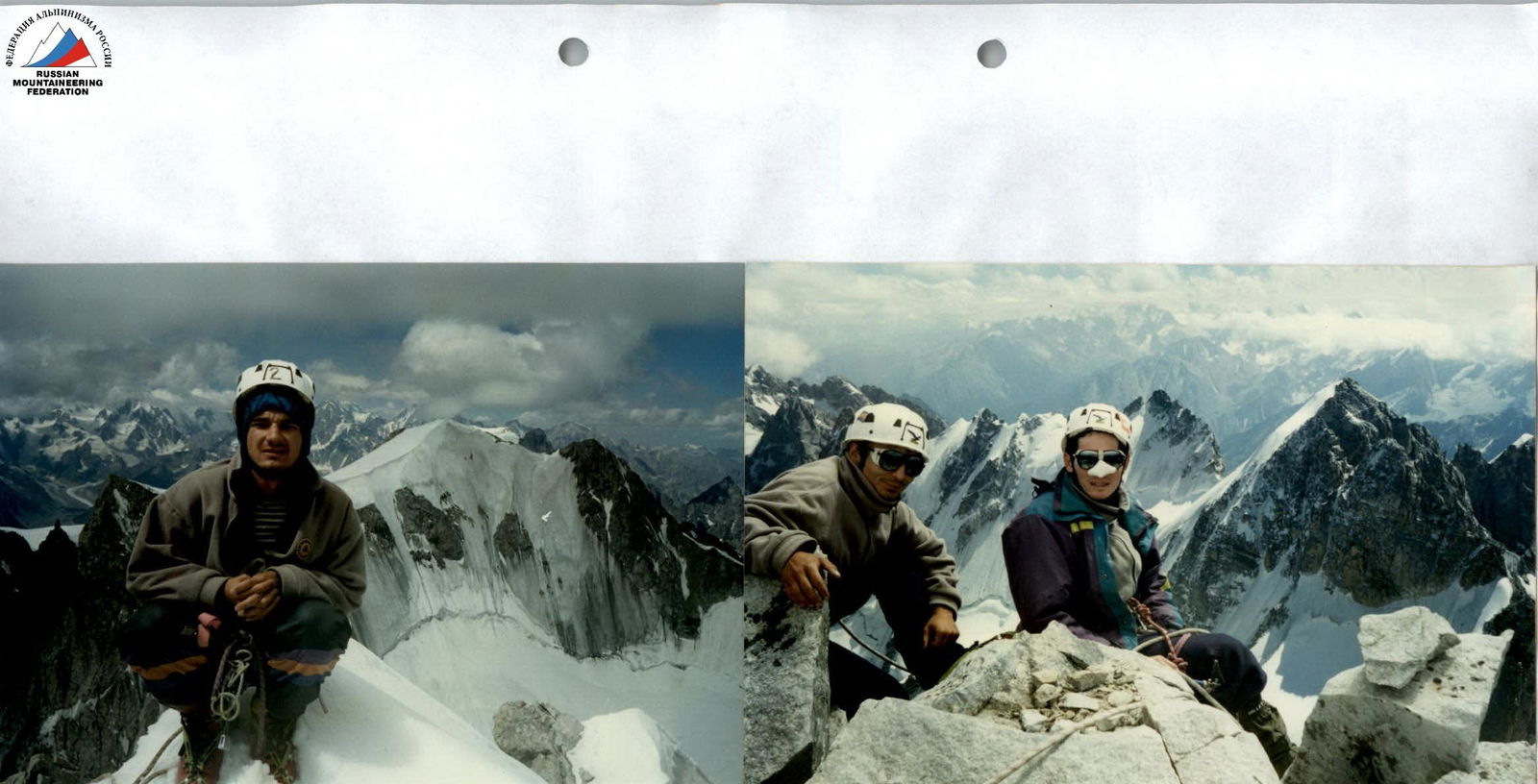
Photo #20. Team on the summit of Sugan-Bashi. From left to right: Egorin S. V. (Sugan-Tau in the background), Afanasiev I. O-S., Ivanov V. V. (Doppakh ridge in the background). August 30, 1997, 17:00.
Ascent Debriefing Protocol
Protocol of the debriefing of the ascent by the SORSRS team and the "Ossetia" mountaineering club to Sugan-Bashi peak via the right part of the Eastern wall, category 6A, from August 28 to 30, 1997.
Attendees: Team:
-
Egorin S. V. — ascent leader
-
Afanasiev I. O. — participant
-
Ivanov V. V. — participant
-
Korablin B. N. — team coach
-
Rodionov V. T. — head of the Tsey PSS
-
Lunev B. G.
-
Rudnev D. Ya.
The debriefing began with the ascent leader, Egorin S. V., presenting.
"Started the approach on August 26. The weather was good. By evening, we reached the Sugan overnight camps and spent the night there. The next day, we started early to reach the Suan pass as quickly as possible. It's necessary to ascend its southern slopes as soon as they are lit by the sun, as rockfalls