- Rtsyvashki — Gyul'chi (combined route by I. Leonov, category 4B, fig.
14). From the tourist center lodge under the slopes of the North-Eastern ridge of the Nameless
peak, on a wide grassy clearing in the Karasu valley, on the right bank of the Dykhsu river,
at the entrance to the canyon of the same name (group of 4-8 people), descend along the trail
to the Karasu river and cross it via the bridge. From the river, ascend along the grassy slopes,
then along the scree and simple, destroyed, partly steep rocks to the 1st gendarme of the
South-Western ridge of Rtsyvashki peak. Further along the long, destroyed, simple and
moderately difficult, partly snowy (possible cornices) rocky South-Western ridge with short
sections of above average difficulty, overcoming gendarmes head-on or bypassing them,
approach the Big Gendarme. From here, along the snowy steep rocks of moderate and above
average difficulty (“live” stones, possible snow cornices — piton protection) of the
South-Western ridge, ascend 150-170 m to the Big Gendarme. From the gendarme, descend via
rappel, then sport climbing, further along simple rocks — to the saddle of the South-Western
ridge. Along a short horizontal sharp snowy (cornices) ridge, then along a steep snowy slope,
further along steep rocks above average difficulty of a 25-meter wall (piton protection),
ascend to the Pre-summit Gendarme. From the gendarme, along the destroyed South-Western
ridge, descend to a snowy saddle. 200 m behind the gendarme is a bivouac. From the initial
bivouac 14-16 hours. From the bivouac, along steep rocks of moderate difficulty, then along a
steep ice-snow (cornices) 250-300-meter South-Western ridge (piton protection), ascend to
the Western Rtsyvashki summit. From the bivouac 1.5-2 hours. From Western Rtsyvashki,
along a sharp snowy (cornices) arcuate 120-150-meter ridge with a deep saddle and a steep
60-meter ascent (piton protection), ascend to the Eastern (Main) Rtsyvashki summit. From
the Eastern summit, descend 120 m towards Gyul'chi peak, first along a steep snowy,
moderately difficult rocky ridge, then along the slope, further along a steep, narrow
40-meter ice-snow couloir to the ridge of the main massif. From here, along a sharp snowy
(cornice) 100-120-meter ridge, approach the Black Gendarme. Overcome it head-on along
rocks above average difficulty of a 40-meter wall (piton protection) and descend along
rocks of moderate difficulty to a saddle below the rocky “saw”. Further, move along a sharp
simple and moderately difficult, partly snowy 150-170-meter rocky ridge of the “saw” with
numerous low gendarmes and a 30 m rappel from the last gendarme. Behind the “saw”, 120 m
along a simple ridge, overcoming small gendarmes head-on, then 120 m along the edge of
rocks and snow until exiting onto a snowy pad below Gyul'chi summit rise. Here is a bivouac.
From the previous bivouac 10-12 hours. From the pad, along a short snowy ridge (left —
cornices), then 200 m along a steep and sharp (piton protection) ridge, ascend to Gyul'chi
summit. From Western Rtsyvashki 7-9 hours. Descend from the summit along the ice-snow
Eastern slope (see route 52). Duration of the route is 3-4 days. It is better to descend from
the summit early in the morning due to avalanche danger.
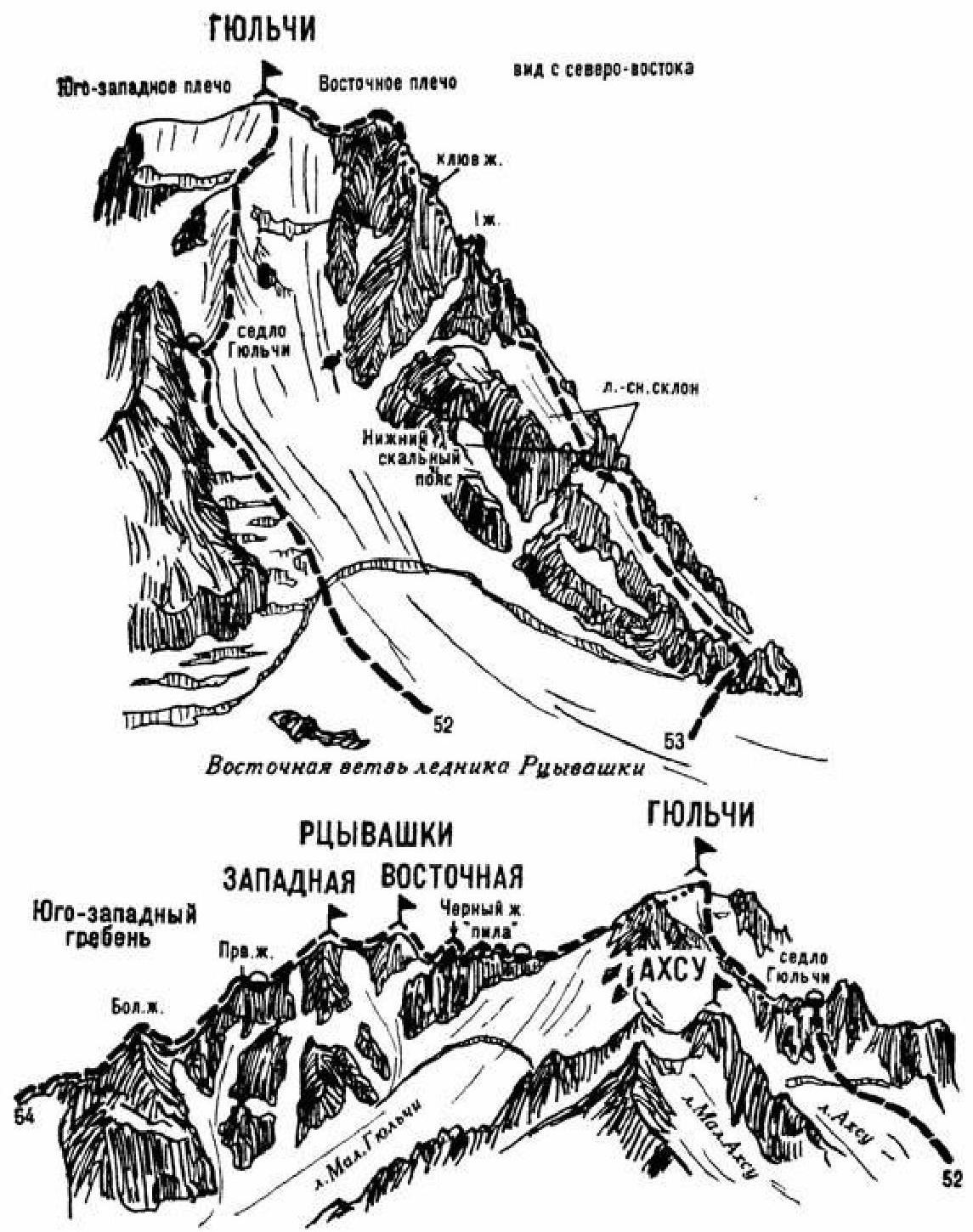
Fig. 14.
