Ascent Passport
-
Digoria, Sugansky ridge, Classification section number 2.6.
-
p. Naumova (3602 m) – from the South.
-
Proposed 2A category of complexity, first ascent.
-
Route character — rocky.
-
Route height difference – 300 m (from point R0).
Total route length – 510 m. Length of sections with 4th category of complexity – 30 m. Average steepness:
- key sections – 70°
- entire route – 40°
-
Hooks left on the route – none.
Number of placed protection gear on the route – 7.
-
Climbing hours – 5; 1 day.
-
Leader: Egorin Sergey Vladimirovich – Master of Sports
Participants:
- Zhirnov Dmitry Nikolaevich – 2nd sports category
- Rodin Alexander Vladimirovich – 2nd sports category
-
Coach: Egorin Sergey Vladimirovich.
-
Approach to the route: July 8, 2004.
Summit ascent: July 8, 2004. Return to the Base Camp: July 8, 2004.
-
Organization: North Ossetian Search and Rescue Team of the Russian Emergency Ministry.

General view of the summit. Peak Naumova from the South. The first ascent route is marked. July. Photo taken during the approach.
Brief Overview of the Ascent Area
The ascent was made in the Eastern part of the Sugansky ridge, the Southern slopes of which are located in the territory of the Republic of North Ossetia – Alania.
The Sugansky ridge is composed mainly of magmatic rocks – granites and diorites.
In the Eastern part of the Sugansky ridge, on its Southern slopes, glaciation is weakly expressed compared to the Western part of the ridge, since the heights of the peaks in the area under consideration drop below 4000 m.
In the cirques, numerous snowfields or remnants of once large glaciers can be found. Everywhere, signs of their activity are visible — scree, moraine ridges, "sheep's foreheads". Above 3000 m, the southern slopes, especially the couloirs and cirques, are covered with numerous scree, which are already starting to become overgrown with advancing vegetation.
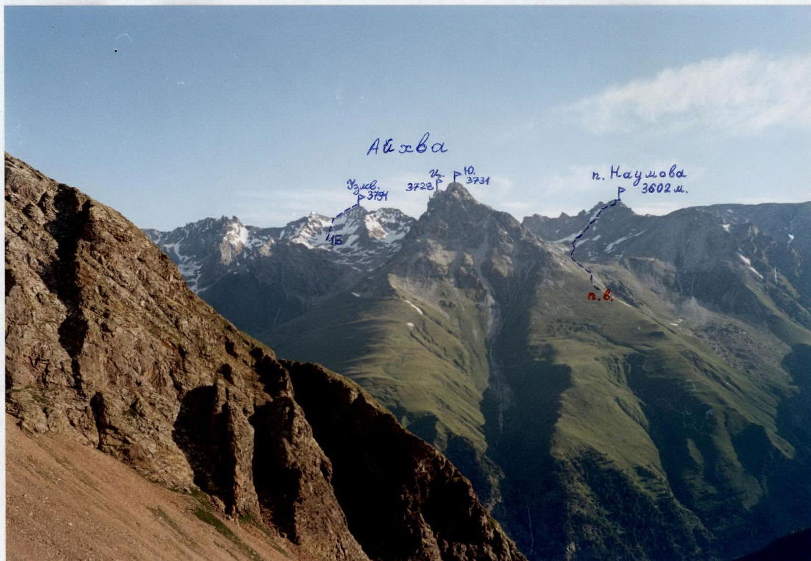
The heights of the peaks after Galdor Glavny and further East nowhere reach 4 km. The average height of the peaks here is 3700–3800 m. The Sugansky ridge has a mainly latitudinal direction and stretches for about 8 km from Peak Botkina to Dashikhoh. Its main spurs in this area are the Belagsky ridge, extending North from v. Aikhva Uzlovaya, and the Aikhvinsky ridge, extending South from v. Aikhva Severnaya.
The Eastern part of the Sugansky ridge was rarely visited by climbers. But starting from 2000, ascents began to be made more frequently. Many new routes were climbed, and the development of the peaks in this area began.
Ascents in this part of the Sugansky ridge are optimal in the first half of summer; the snow melts quickly here, and
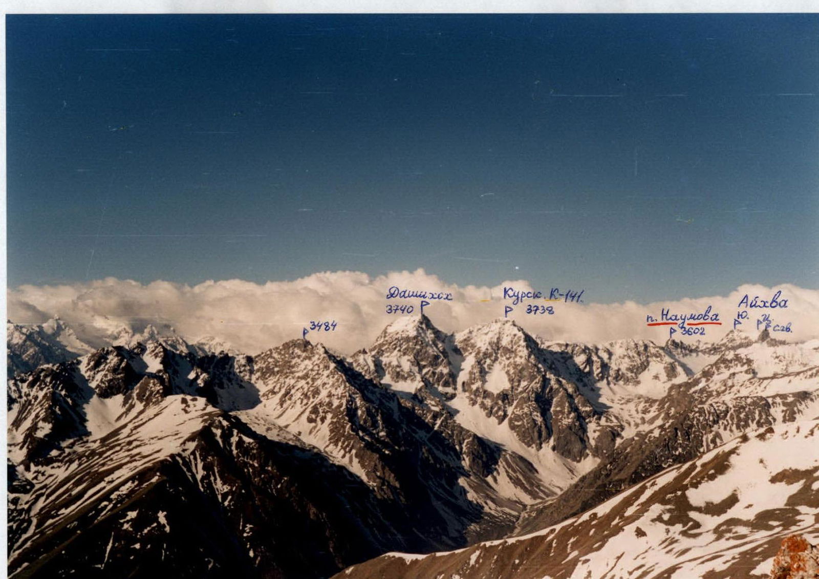
Photopanorama of the area. Sugansky ridge from the South. July. View from the Taymazi glacier. The first ascent route on p. Naumova is marked.

Eastern part of the Sugansky ridge from the North. May. Photo taken from the summit of Uaz (3529 m) – Skalisty ridge.
Description of the Approach to the Route (to the Eastern Aikhvinsky Cirque)
1st option:
From the "Digoria" alpine camp (now the "Komy-Art" sports and recreation camp), ascend along the road up the Khares gorge to the waterfall – about an hour. The waterfall near the road is the Aikhvadon river, flowing out of the Western Aikhvinsky cirque, which is located West of the Southern Aikhvinsky spur of the Sugansky ridge.
Bypass the waterfall along the road and above it, cross the Aikhvadon to the right bank of the river. Then ascend up towards the visible massif of Aikhva. First, walk through the meadows, then exit onto the right grassy ridge and continue along it until it flattens out into a wide, almost flat, grassy valley — another 1.5 hours. From here, move to the right and cross the river (altitude 2700 m), then ascend up to the right along the slope to a terrace with an old geological road. First, follow the road, then use the trails to move up to the right (East), bypassing the Southern slopes of Aikhva Malaya. In another hour or an hour and a half, gradually enter the lower part of the Eastern Aikhvinsky cirque. The path goes through scree and, in the first half of summer, through snowfields. Overnight stay is possible here — altitude about 3100 m.
2nd option:
From the "Digoria" alpine camp, descend down the Khares gorge for 1.5 km (from the "Rostselmash" sports and recreation camp, ascend up the gorge for 0.5 km) to the river with a waterfall upstream — here is the water intake for the "Rostselmash" S.R.C.
To the left of the river, follow the trail up through the forest. About 50–70 m before the waterfall, turn left onto a trail that bypasses the waterfall. The trail is trodden by animals and is not always visible.
The path up goes mainly along the ridge, through grass, and in places through a pine forest. Rocks are bypassed along ledges or walls of 1–2 category of complexity. The trail is steep, and during rain, belaying may be necessary (especially during descent).
Gradually, as the forest and rocky sections end, the ridge begins to flatten out, and the lower part of the Eastern Aikhvinsky cirque becomes visible ahead. Then traverse the grassy right slope and enter the cirque along the scree; overnight stay is possible here, altitude about 3100 m. The ascent from the road is about 1300 m, 3–4 climbing hours. The second approach option is shorter but technically more complex and can be recommended only for strong groups.
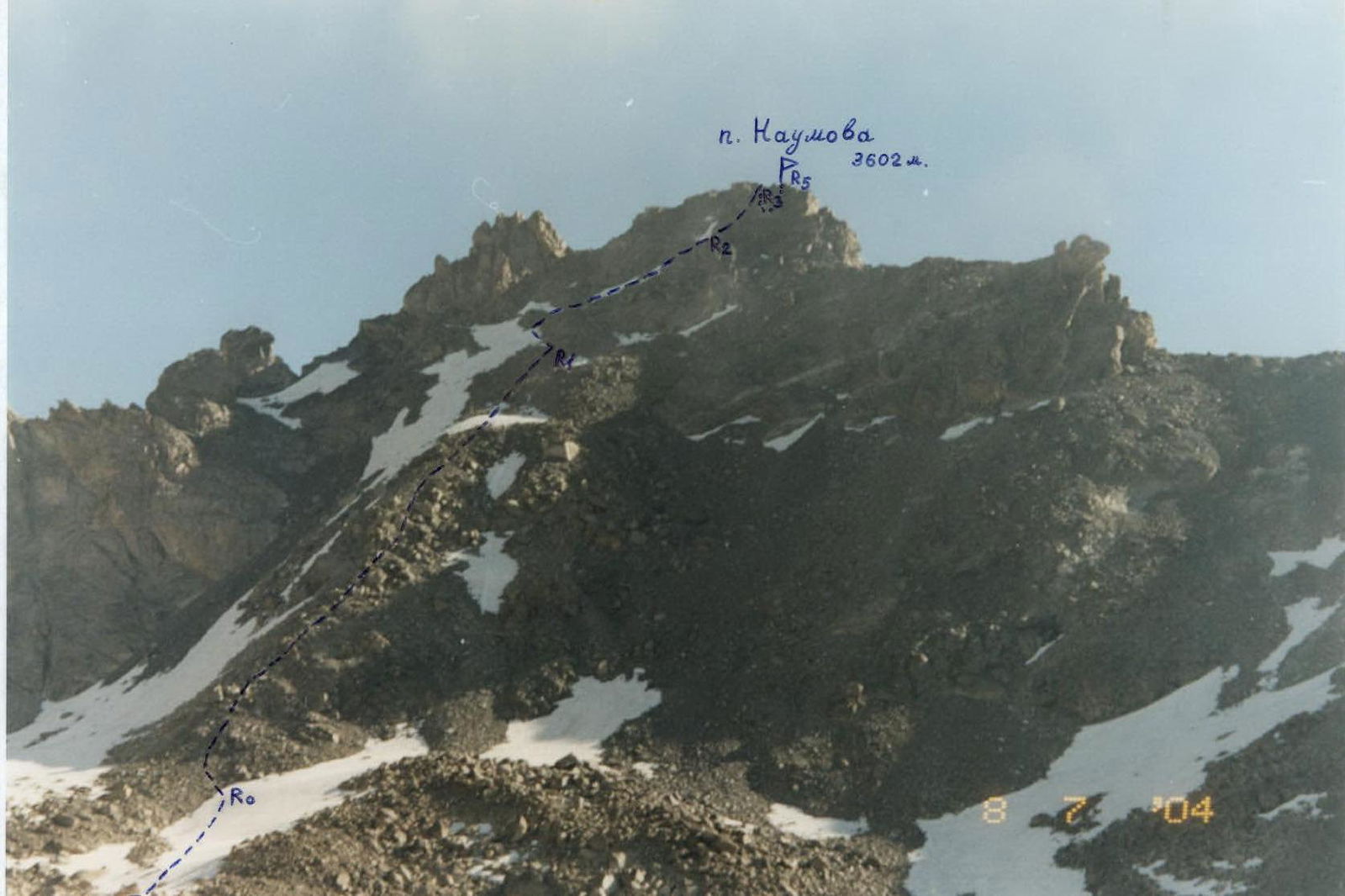
Peak Naumova from the South. The first ascent route is marked. July.

Route Description
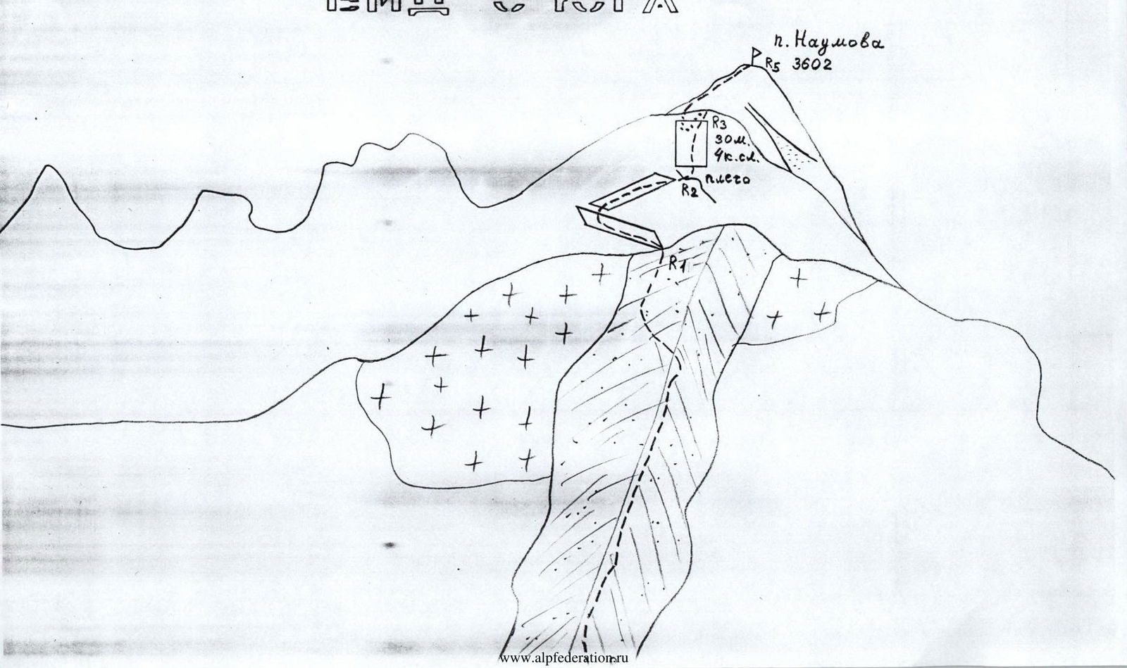
From the overnight stay in the Eastern Aikhvinsky cirque, ascend directly up the scree towards the visible sub-summit of Peak Naumova. A wide, not clearly defined rocky-scree counterfort approaches it; approach its base.
Section R0–R1:
Along the right part of this counterfort, bypassing rocks along ledges, ascend up to rocky outcrops. Section 300 m; 1–2 category of complexity; 20–25°.
Section R1–R2:
Under the rocks, first move up to the left along scree, then up to the right along a ledge (possibly snow-covered) to a scree shoulder. The entire section is about 100 m; 1–2 category of complexity; 30°.
Section R2–R3:
From the shoulder, up the wall to the right — 40 m to the ridge against the sky. This is the sub-summit. On this section, 30 m is 4th category of complexity, and 10 m is 3rd category of complexity.
Wall is 60–70°.
Belaying is necessary!
Section R3–R4:
From the sub-summit, on the North side of the ridge, move down to the left onto a connecting ridge (loose rocks!) — 40 m; 3rd category of complexity.
Section R4–R5:
From the connecting ridge, along a 40° ridge, 30 m long; 2–3 category of complexity, ascend to Peak Naumova (3602 m). The summit is a good panoramic point.
No signs of human presence were found on the summit. We propose to name the summit in memory of the well-known mountaineer Naumov A.F.
From the overnight stay to the summit, it takes about 5 hours for a training group. Descent is via the ascent route.
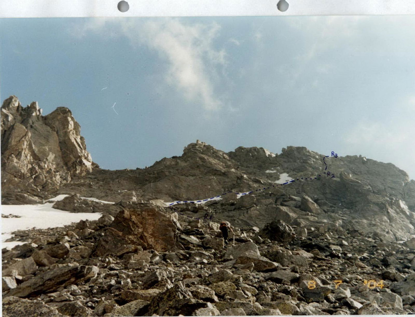
Passage of the upper part of section R0–R1.
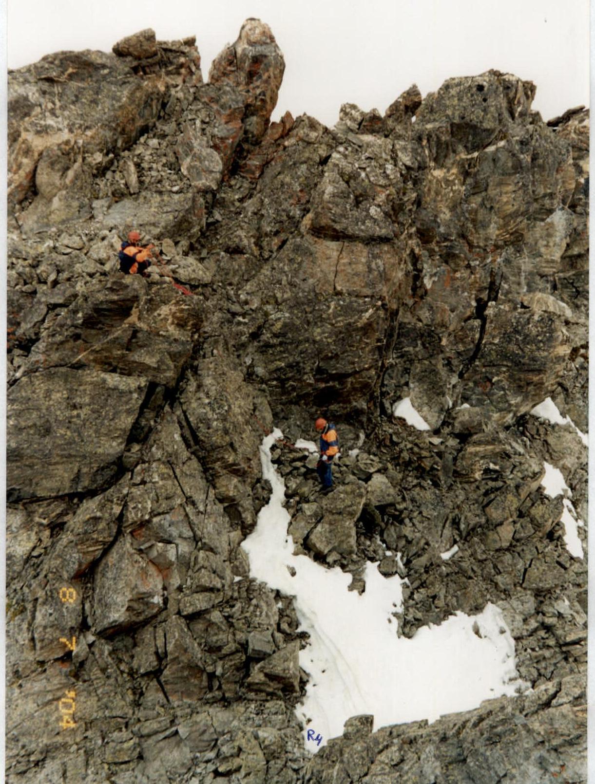
Passage of section R3–R4. Descent from the sub-summit.
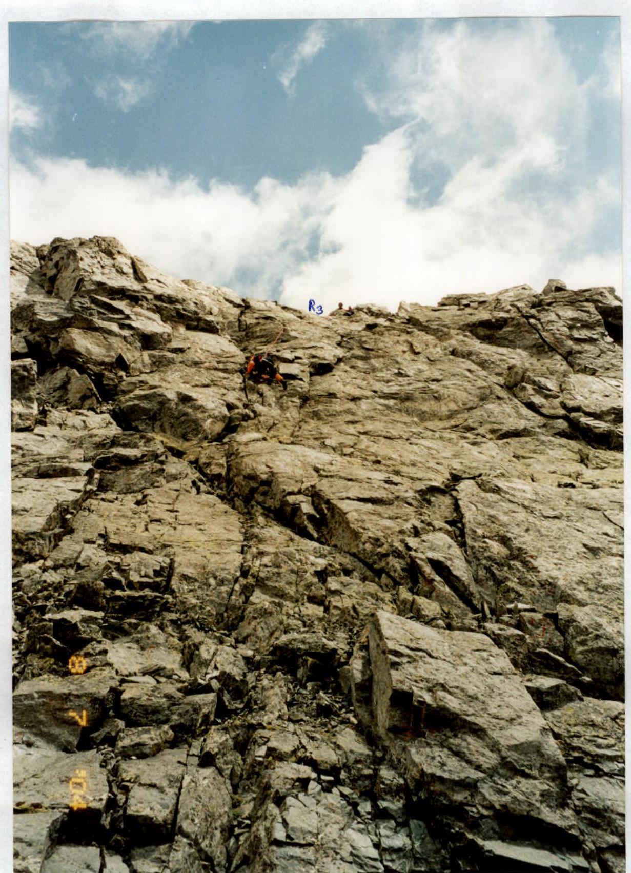
Passage of the key part of the route. Along the wall — on section R2–R3.