To the Classification Commission of the USSR Alpine Federation
Description
of the ascent route to the summit LABODA GLAVNAYA (4134 m) via the right northwestern counterfort (first ascent)
Leningrad — 1971
I. Brief information on the geography of the area, group composition, and tactical plan of the ascent
The ascent to the summit Laboda Glavnaya via the right northwestern counterfort was made from July 5 to July 11, 1971, by a group of climbers from LOS DSO "Trud" comprising:
- Shevchenko Yu.S. — Master of Sports — leader
- Shalygin Yu.V. — Candidate Master of Sports — participant
- Smirnov A.A. — Candidate Master of Sports — participant
- Lazarev V.P. — Candidate Master of Sports — participant
- Nosov A.P. — Candidate Master of Sports — participant
The Laboda massif is located in the central part of the Main Caucasian Range in mountainous Digoria. To the west of Laboda lies the vast area of Caucasian giants — Bezengi, and to the east — the Tsey peaks. The massif includes three peaks: Western, Main (4134 m), and Eastern. Laboda drops steeply to the northwest with 1.5 km high walls, on which several routes of 5B and 4B difficulty categories are laid. The most challenging and interesting routes from an alpinist's perspective are the paths taken by V. Gerasimov's group (5B–6A category) and V. Egorov's group (5B–6A category) along the walls of Western Laboda.
Approaching the northern walls of the Laboda massif, although not technically difficult, takes about 8 hours from the Taymazhi meadow, where the alpine camp is usually located (see the map of the area). The southern slopes of the Laboda massif are relatively gentle and not difficult (2–3 category).
The ascent route via the right northwestern counterfort, proposed by our group by V.A. Gerasimov, the head of the training department at the "Torpedo" alpine camp, immediately attracted attention with its strict logic. It is clearly demarcated from other sections of the Laboda massif and, judging by the photographs, had a length of not less than the known path to peak Krumkol along the junction of the walls (6B category), i.e., approximately 2000 m.
Characteristics of the route:
- Although the overall steepness of the route is not very great, its rocky bastions are sheer, monolithic, and do not allow for safe retreats.
- The upper bastions and ridge leading to the plateau under the summit snow-ice dome have a combined rock-ice character.
- The route, in its severity, combined nature, and length, had a Bezengi character.
Despite the fact that the group leader Shevchenko Yu.S. and participant Nosov A.P. had about 15 first ascents of routes of 5B and 6B categories, they approached the counterfort with some trepidation. In the conditions of unstable weather in this area, the route required the group to be cohesive and have clear, thought-out actions.
As can be partly seen in photo 1, the counterfort consists of four rocky bastions and a rocky-ice ridge leading to the snowy plateau under the snow-ice dome of the summit. The bastions are connected by rocky-ice ridges.
The tactical plan included passing the route with 3–4 bivouacs on the counterfort (see the route sheet).
It is worth noting that by the time of the ascent to Laboda, the group was in excellent sports form, having completed the first ascent in the Tsey area to peak Moskvich through the "black" gendarme (4B–5A category) and peak Passionarii (5B–6A category), with the latter route being completed in 6 hours thanks to the application of several tactical techniques:
- traversal of most sections by independent pairs;
- movement in galoshes;
- reduction of backpack weight through the use of titanium gear, special down-filled clothing, and special sublimated and tubed rations.
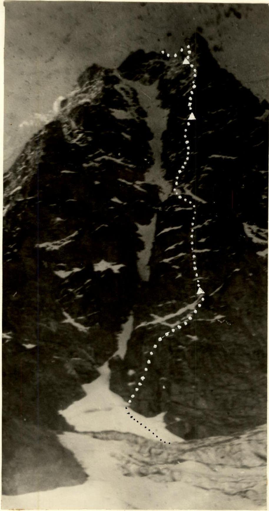
Photo 1-B. Northern counterforts of Laboda mountain
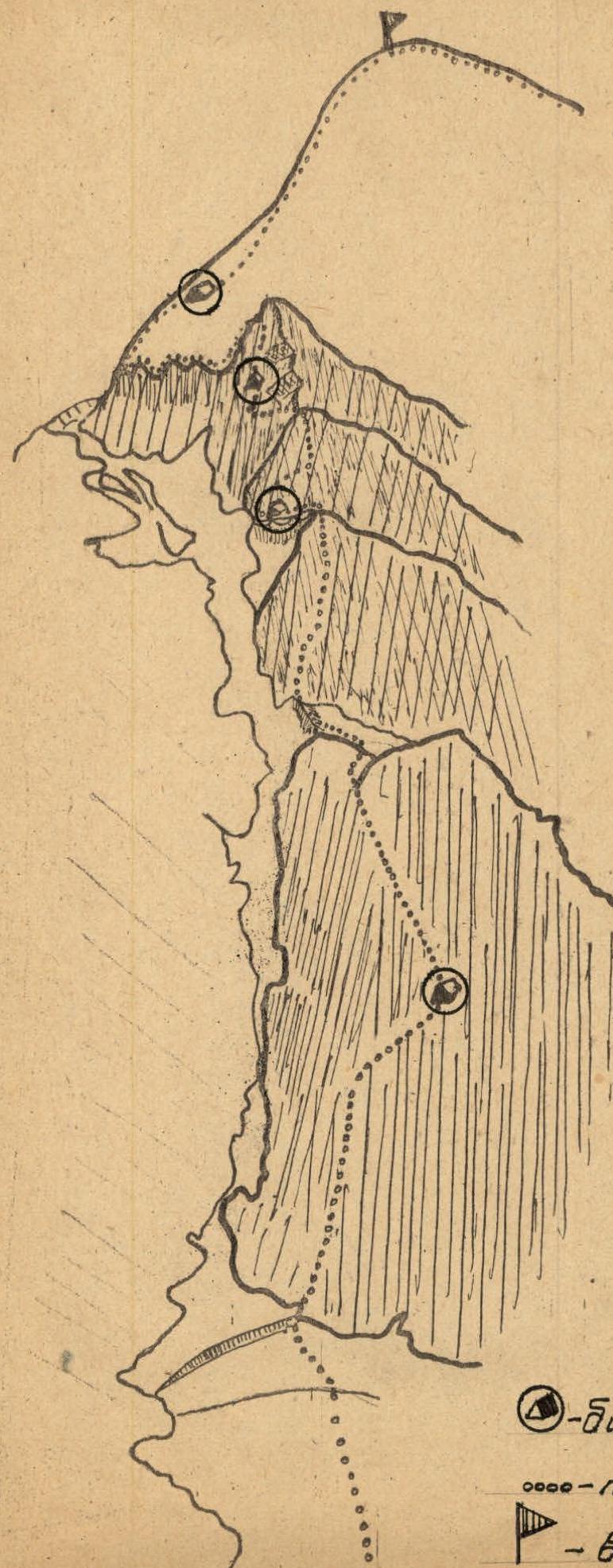
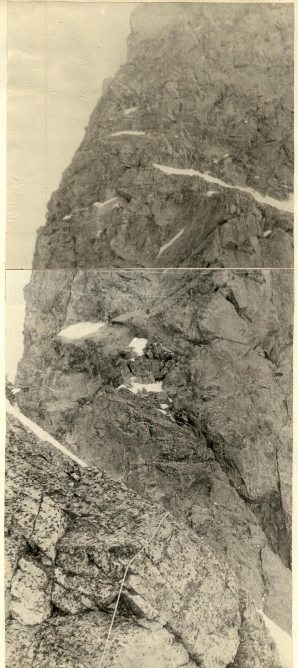
Photo 2. Base of the wall of the II bastion (sect. 21–24)
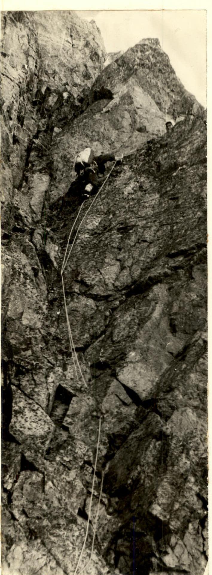
Photo 8. Slabs on the wall of the III bastion (sect. 32)
II. Description of the ascent
1st day. The group left the camp at Taymazhi meadow on July 6, 1971, at 6:00 and set up a bivouac on the Tshubuni glacier at 16:20, observing the route.
2nd day. Departure at 6:30. Movement in crampons. Initially, the path goes along a 40-degree snow-ice slope and in places along cemented avalanche debris in the general direction towards the throat of the main couloir. They approached the bergschrund and then traversed complexly along the accumulations of ice blocks to the rентклуфт and rocks of the right counterfort. Overcoming the rентклуфт and exiting to a snowy shelf is complex and requires piton belay.
The path along the rocks of the I bastion initially goes upwards to the right (2 ropes). Here, on the shelf, a control note is left in a cairn. Sections 2–3–4 up to the I control cairn represent an alternation of vertical steep walls (85–90°) and narrow oblique shelves. From the control cairn, they turned left towards the couloir separating the right and left counterforts. At the end of the day, a bivouac was set up under an overhanging wall. A 2nd control cairn is also located here.
Overall, the route of this day (about 300 m of the lower part of the I bastion) can be characterized as a combination of diverse forms of rocky relief:
- sheer walls with overhangs and few holds;
- internal and external corners;
- sections overcome by friction and more.
Confident overcoming of it is possible only for climbers with good rock climbing technique and physical fitness. Particularly noteworthy are sections 4 and 7, where the group had to organize 10-meter rope hauling and use ladders. All rocky sections on this day were traversed by the group members in galoshes. Many unstable rocks required constant attention and caution.
On the first day of the ascent, the group worked for about 10 hours.
3rd day.
- Departure at 7:00
- Overcast
- Poor visibility
- Wind
- Cold
For the day, the upper part of the I bastion (sections 10–17), the ridge leading to the 2nd bastion (sections 18–20), and the wall of the 2nd bastion (sections 21–30) were traversed. On the snow-ice ridge under the wall of the 3rd bastion, a platform was hewn out, and a 3rd control cairn was left.
Overcoming the relief of the 3rd day of ascent required enormous physical and mental strain from the participants (a path of approximately 800 m was laid, which took 14 hours 30 minutes).
The upper part of the I bastion consists of multiple repetitions of internal and external corners up to 40–50 m long. Exits from internal corners were usually blocked by overhangs, which forced:
- complex detours;
- use of ladders;
- rope hauling (sections 11 and 14).
The wall of the 2nd bastion is shorter but much more technically complex than the wall of the I bastion. In many areas, the rocks are covered with rime ice, and the first climber expended a lot of effort on pathfinding and organizing belay points. Particularly challenging were sections 21, 23, 25, 27. For example, section 25 is a 20-meter wall with a steepness of 90–100° and overhanging unstable rock blocks. There are very few places for piton placement.
4th day. The weather is overcast. Wind. Sleet. Poor visibility. On this day, the group overcame the wall of the 3rd bastion. Climbing is complex and very challenging, with additional psychological strain: 4 overhanging sections, one of which is 20 meters with rope hauling and the use of artificial holds. Then, a moderately difficult rocky ridge was traversed, and part of the 4th bastion was climbed. It is impossible to climb the wall of the 4th bastion directly head-on because it rises above the ridge with sheer steps to a height of more than 200 m. The group conducted a reconnaissance of a detour to the right but, not finding an acceptable path, chose a variant of overcoming the bastion to the left along its northern face. The detour begins with a traverse of 80 m (section 43) along a slope of rime ice flowing from under the overhanging wall. Individually protruding rocks. Steepness 65–70°. A glacial couloir is intersected, exiting onto a saddle. The traverse was made in crampons with multiple step-cutting. The difficulty of this section is characterized by the need to place 8 rock pitons, 12 ice screws, and use a ladder. The work was complicated by poor visibility (30–50 m), wind, and wet snow. On the same day, the group managed to climb from the saddle upwards through an overhanging section 44 about 100 m and on an ice slope with a steepness of 55° under the negative wall, they hewed out a narrow shelf in the ice where they organized a sitting bivouac. Due to the insignificant thickness of the ice, it was not possible to hew out a larger platform. The group worked on the route for 14 hours 30 minutes on this day.
5th day. Departure at 7:00. Calm. Fog. Visibility not more than 50 m. From the sitting bivouac to the left and then upwards, very complex climbing was done along an oblique internal corner filled with rime ice, 30 m long, with a steepness of 60°. The right face overhangs. Then follows a vertical convex wall almost without holds, 15 m (type of "ram's forehead") — section 50. Very complex. After 40 meters of climbing of moderate difficulty along the rocks, it was possible to exit onto the ridge above the 4th bastion. The path after the 4th bastion is a stepped ridge (300 m) with vertical 15–30-meter walls. Technically, the movement is not more than moderately difficult. The rocky ridge leads to an extensive snow-ice plateau. At the exit, a 4th control cairn was left. Movement was greatly hindered by fog, and the group had to wait for an improvement in weather. The path across the plateau and along the snow-ice ridge for a qualified group does not present complexity, although it requires increased attention due to the danger of avalanches from the summit dome.
At 17:00, the ascent participants reached the summit and soon began their descent along the ridge of 2B category to the Tana–Tsete glacier, where they stopped for the night. The path to the summit required 10 hours of work on this day.
6th day:
- Descent to the camp along the Tana–Don glacier and valley (6 hours).
The technical characteristics of the route are given in the table.
III. Main equipment of the group
- 4-person tent — 1
- Main rope 45 m — 2
- Auxiliary rope 45 m — 1
TABLE OF MAIN CHARACTERISTICS OF THE ASCENT ROUTE
Ascent route — Glavnaya Laboda (4134 m) via the right northwestern counterfort — (first ascent)
Height difference of the route 4134 m – 2500 m (Tshubuni Glacier). Average steepness of the route – 62° (up to the exit to the plateau). Length of the traversed path – 2520 m
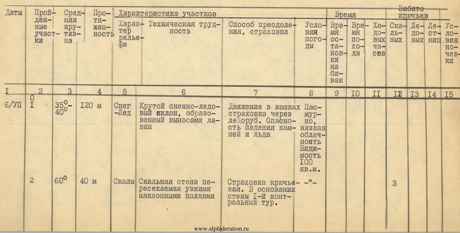
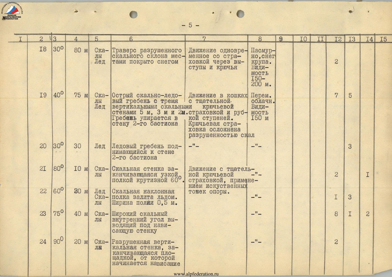
| 1 | 2 | 3 | 4 | 5 | 6 | 7 | 8 | 9 | 10 | 11 | 12 | 13 | 14 | 15 |
|---|---|---|---|---|---|---|---|---|---|---|---|---|---|---|
| 6/VII | 3 | 85–90° | 15 м | Скалы | Vertical internal corner formed by a chipped-off rock feather and an overhanging wall | Piton belay, few cracks. | Overcast, low cloud cover. Visibility 100 m | 2 | ||||||
| 4 | 80–85° | 30 м | Скалы | Vertical wall with an overhang. Holds are fragile and very small. | The overhang is bypassed by a complex traverse to the right 5 m and then upwards along the wall 25 m. | "–" | 8 | 3 | ||||||
| 5 | 50° | 10 м | Скалы | Inclined rocky shelf ending in a convenient ledge for belaying through a выступ | Easy climbing, belaying through ledges | "–" | ||||||||
| 6 | 75–80° | 40 м | Скалы, лёд | Rocky wall with ice in the lower part. The wall turns into a broad rocky-ice couloir in the upper part, the throat of which is bypassed on the left along an internal corner with an overhanging left side of the corner. The internal corner ends in a dead end. | Complex climbing, piton belay. Rockfall hazard! | "–" | 5 |
| 1 | 2 | 3 | 4 | 5 | 6 | 7 | 8 | 9 | 10 | 11 | 12 | 13 | 14 | 15 |
|---|---|---|---|---|---|---|---|---|---|---|---|---|---|---|
| 7 | 75° | 40 м | Скалы | Rocky wall with a 3-meter vertical wall and then an overhanging 5 m rocky chute leading to slabs. | Piton belay. Use of artificial holds. | "–" | 5 | 2 | ||||||
| 8 | 60° | 40 м | Скалы | Rocky slabs | Few holds, few cracks for pitons, friction climbing | "–" | 2 | |||||||
| 9 | 45° | 60 м | Скалы, лёд | Oblique shelf under an overhanging wall. The shelf is covered with ice, leading to a rocky-ice ridge where a platform can be constructed for setting up a bivouac. | Movement along the shelf along the rocky edge. Belaying through ice screw pitons. 2nd control cairn. | "–" | 3 | 3 | ||||||
| 10 | 30° | 10 м | Скалы | Rocky-ice ridge leading to an overhanging wall. To the right is a deep vertical chute. | At the beginning of the ridge, through a 2-meter wall on a snowy ridge, a platform for the 1st bivouac on the wall was constructed. | "–" | 1 | Good condition. 5 people in the tent | ||||||
| 7/VII | 11 | 95° | 7 м | Скалы | Overhanging destroyed wall | Passed by complex climbing without a backpack and using ladders | Overcast | 3 | 2 | |||||
| 12 | 90° | 35 м | Скалы | External corner with a smoothed edge. | Complex climbing with piton belay | Low cloud cover | 3 |
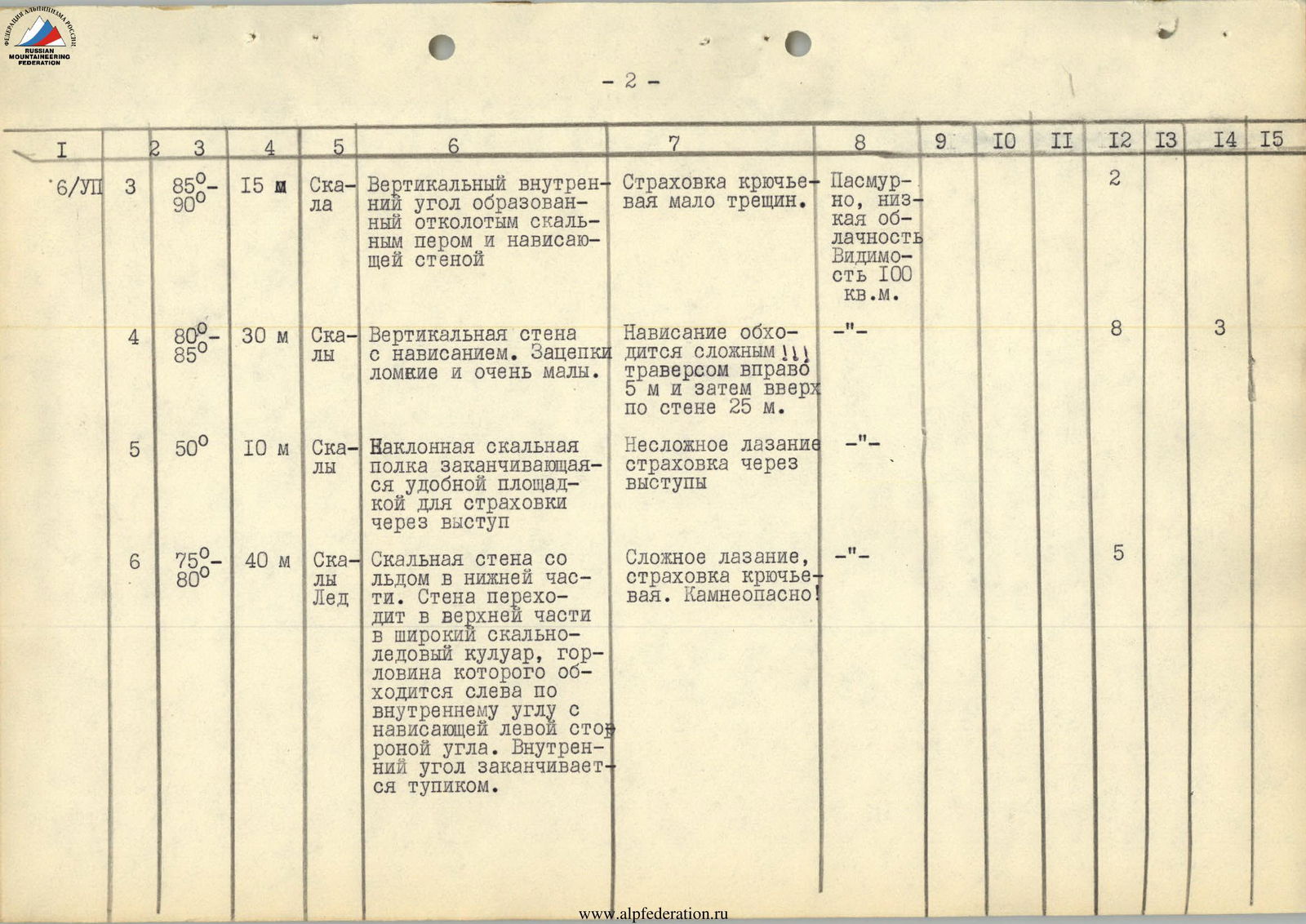
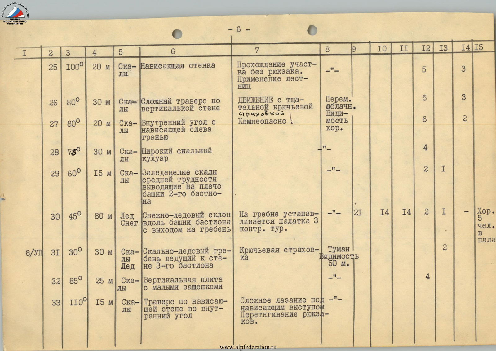
| 1 | 2 | 3 | 4 | 5 | 6 | 7 | 8 | 9 | 10 | 11 | 12 | 13 | 14 | 15 |
|---|---|---|---|---|---|---|---|---|---|---|---|---|---|---|
| 13 | 60° | 30 м | Скалы | Rocky wall of moderate difficulty leading to a narrow shelf | Climbing of moderate difficulty, belaying through pitons and ledges | Overcast. Low cloud cover. Visibility 100–150 m | 1 | |||||||
| 14 | 80° | 45 м | Скалы, лёд | Rocky wall ending in an obliquely overhanging cornice, which is bypassed by complex 5 m climbing to the right | Complex climbing! Rockfall hazard from the chute on the right. The first person goes without a backpack on a 10 m section | "–" | 6 | 1 | ||||||
| 15 | 70–75° | 75 м | Скалы | Steep slabs complicated by rime ice. Behind the slabs follows an overhanging tower of the I bastion | Movement along the slabs is complicated by ice. Necessary to clear rocks from ice in search of cracks for pitons. | "–" | 6 | 2 | ||||||
| 16 | 60° | 30 м | Скалы, лёд | Steep slabs with snow and ice | Descent along the slabs bypassing the tower of the I bastion | "–" | 1 | |||||||
| 17 | 80° | 30 м | Скалы | Vertical destroyed rocky chute leading to the shoulder of the tower of the I bastion | The chute is passed by climbing in opposition with piton belay. Rockfall hazard! | "–" | 5 |
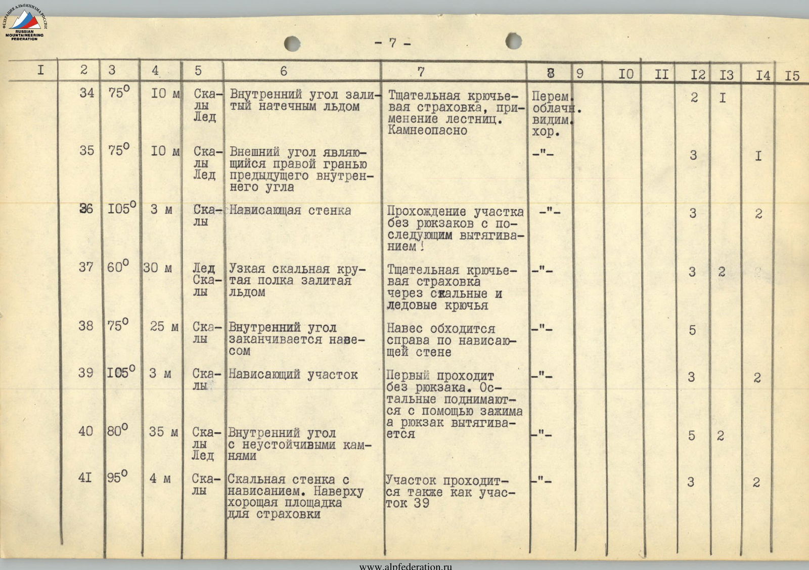
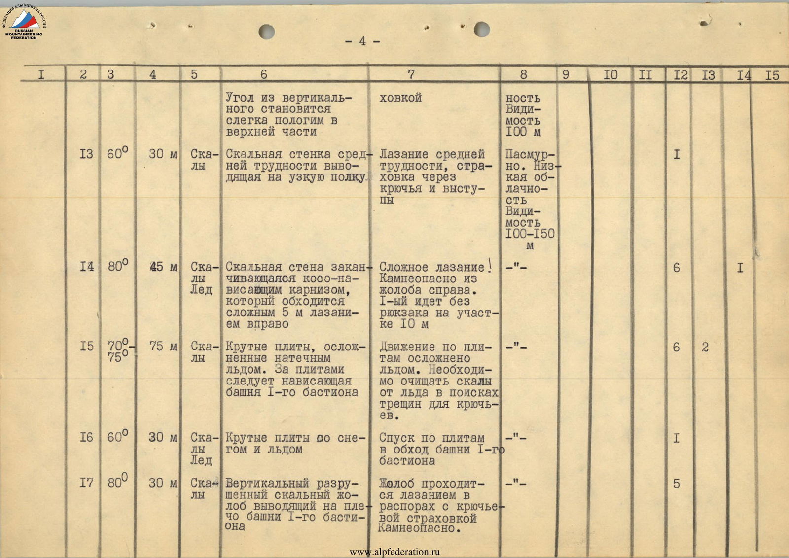
| 1 | 2 | 3 | 4 | 5 | 6 | 7 | 8 | 9 | 10 | 11 | 12 | 13 | 14 | 15 |
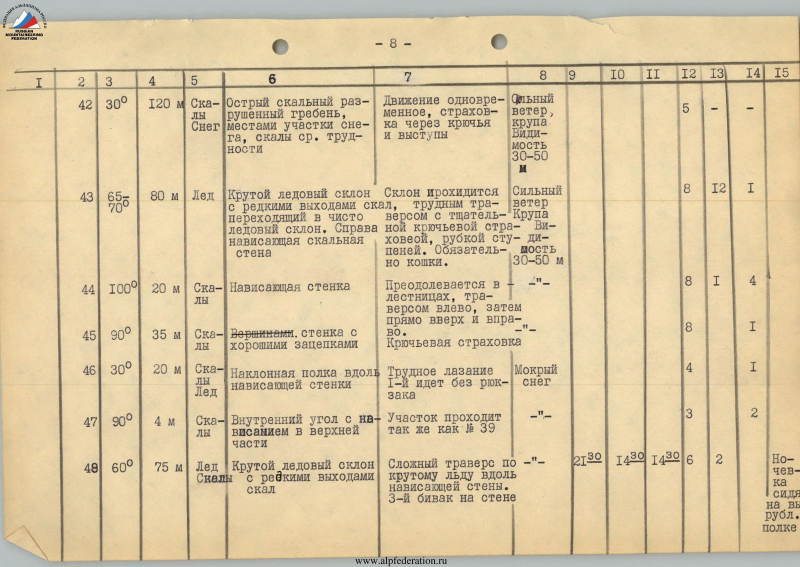
|---|---|---|---|---|---|---|---|---|---|---|---|---|---|---|
| 42 | 30° | 120 м | Скалы, снег | Sharp rocky destroyed ridge, местами участки снега, скалы средней трудности | Simultaneous movement, страховка through pitons and ledges | Strong wind, sleet. Visibility 30–50 m | 5 | |||||||
| 43 | 65–70° | 80 м | Лёд | Steep ice slope with rare rock outcrops, turning into a purely ice slope. To the right is an overhanging rocky wall | The slope is traversed with careful piton belay, step-cutting. Crampons mandatory. | Strong wind. Sleet. Visibility 30–50 m | 8 | 12 | 1 | |||||
| 44 | 100° | 20 м | Скалы | Overhanging wall | Overcome in ladders, traversing left, then straight up and right. | "–" | 8 | 1 | 4 | |||||
| 45 | 90° | 35 м | Скалы | Wall with good holds | Piton belay | "–" | 8 | 1 | ||||||
| 46 | 30° | 20 м | Скалы, лёд | Inclined shelf along an overhanging wall | Difficult climbing. The first person goes without a backpack | Wet snow | 4 | 1 | ||||||
| 47 | 90° | 4 м | Скалы | Internal corner with an overhang in the upper part | The section is passed similarly to section 39 | "–" | 3 | 2 | ||||||
| 48 | 60° | 75 м | Лёд, скалы | Steep ice slope with rare rock outcrops | Complex traverse along steep ice along the overhanging wall. 3rd bivouac on the wall | "–" | 21:30 | 14:30 | 14:30 | 6 | 2 | Overnight stay sitting on a hewn shelf |
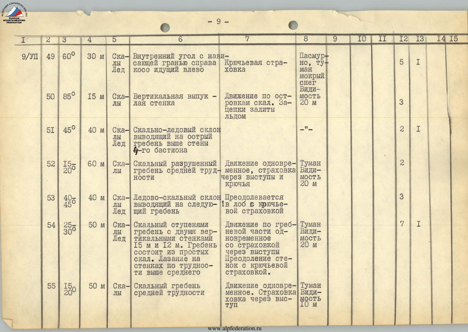
| 1 | 2 | 3 | 4 | 5 | 6 | 7 | 8 | 9 | 10 | 11 | 12 | 13 | 14 | 15 |
|---|---|---|---|---|---|---|---|---|---|---|---|---|---|---|
| 56 | 70° | 30 м | Скалы | Destroyed rocky wall | Belaying through ledges and pitons | Fog. Visibility 10 m | 3 | |||||||
| 57 | 15° | 200 м | Снег | Snowy plateau, slightly rising towards the summit in a couloir | Simultaneous movement in rope teams | Clear | ||||||||
| 58 | 30–40° | 350 м | Снег, лёд | Snow-ice ridge leading to the summit | Simultaneous movement in rope teams, belaying through an ice axe | Clear | 6 | 6 | ||||||
| Descent along the ridge 2Б кат. сл. Bivouac on the Tana–Tsete glacier | ||||||||||||||
| Total: | 195 | 44 | 30 |
Group Leader /SHEVCHENKO/