Ascent Passport
- Ascent type: rock climbing
- Ascent area: Caucasus: 2.6: Sugansky Ridge
- Peak, route: Pik Zagadok, 3737 m: Eastern tower via the Eastern wall
- Estimated category of difficulty: 2A rock: semi-independent
- Route characteristics:
elevation gain — about 650 m, route length — 800 m, section lengths: 2nd category of difficulty — 700 m, average steepness of the main part of the route — 65°
- Pitons used: 3 pcs., chocks — 4, "friends" — 2
- Time spent on the route / days: 7 / 1
- Number of nights spent: 1 — at a bivouac
- Leader: Aleksashin M.I. — II sports category
team members: Baranov A.N. — badge holder + Ashpetov D.A. — III sports category Levitsky Ya.G. — III sports category + Lyublinsky D. — III sports category + Tarasova K.N. — III sports category + Belonozhko M.V. — III sports category
-
Coach: Akhtyrchenko Galina Vasilievna — Master of Sports
-
Departure to the route: August 3, 2003, 05:00 Moscow time Return to the bivouac: August 3, 2003, 12:00 Moscow time
-
Organized by: AUSB "Digoria"
Approach Description
After leaving the AUSB "Digoria" camp, come to the fork in the road along the Sugansky Ridge and turn left. Moving along the serpentine for approximately 1 hour, approach a large waterfall on the right. Take a break here. Then, move 100 m along the road and turn right, where the road makes a sharp turn upwards. Cross the stream on the right (a destroyed kosh remains on the left side) and move to the trail that leads along the grassy ridge past small rock formations steeply upwards (20 minutes from the waterfall). The ascent up the trail along the ridge takes 1 hour. Then, finding yourself on a relatively flat section, turn left and cross the neighboring (left) grassy ridge.
The massif of Pik Zagadok should come into view. Continue up the grassy slope to the scree fields — 1–1.5 hours. Near a large boulder, there are grassy areas. This is where the overnight stay is located.
Important:
- It is not recommended to proceed without a person familiar with the approach in fog!
- For orientation: the overnight stay is separated by two large scree ridges on the left and right.
- The left ridge is "smoothed out" by fine scree.
- Straight ahead, a large couloir should be visible, cutting through the massif of Pik Zagadok.
- The left branch of the moraine formations leads to the glacier of Pik Uruimamagova, the right one — under the Zagadok pass (between the Eastern peak of Pik Zagadok and Aikhva Western).
- Near the campsite, the towers of Pik 3661 rise on the left.
The total time to reach the overnight stay from the camp is 4–4.5 hours.
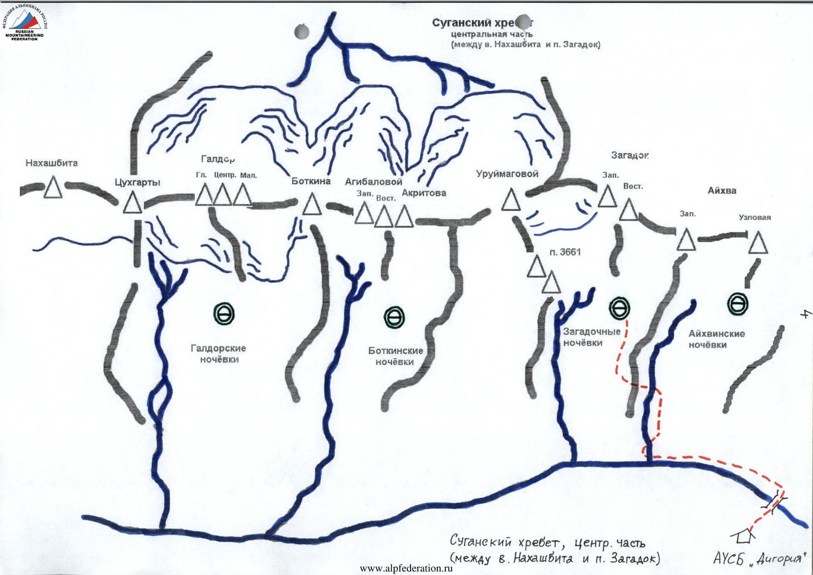
Sugansky Ridge, central part (between v. Nakhashbita and p. Zagadok)
Route Description
After leaving the Zagadochnye campsite and bypassing the spur of p. Zagadok on the right, cross the large scree slope and enter the cirque. The transition takes 30–40 minutes.
Moving across the scree, approach the long couloir leading to the pass between the peaks of Pik Zagadok and Aikhva Western. Ascend the scree (in the lower part — possibly snowy) couloir to the Zagadok pass between Pik Zagadok and Aikhva Western (2–3 hours), keeping to the left side.
From the pass, turn left. After reaching a small, possibly snowy, couloir (100 m) to the wall, organize the first belay station. The wall is circumvented on the left via a wide ledge (35 m) and an internal corner. After 20 m, sharply turn right and exit to the upper part of the wall. A control cairn is located here.
Easy climbing leads to the sub-summit, and then to the summit itself. Confirmation of reaching the summit is the view of the Western peak's wall and the peaks of the western branch of the Sugansky Ridge.
Descent from the summit:
- initially via easy climbing,
- then via rappelling down the eastern wall towards the saddle between Pik Zagadok and Aikhva Western.
Once on the saddle, descend south through the scree (possibly snowy in places) couloir.
The route is logical and objectively safe.
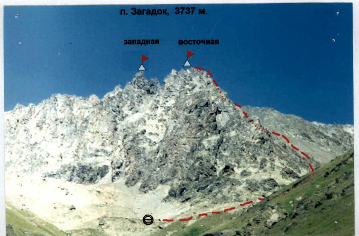
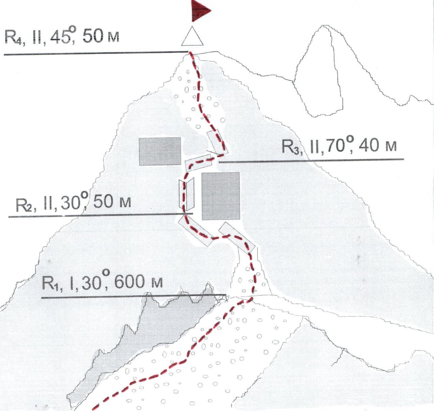
Table of Main Characteristics of Route Sections
| Section # | Steepness, degrees | Length, m | Terrain characteristics | Category of difficulty | Belaying method |
|---|---|---|---|---|---|
| R0 | 30 | 100 | Scree | 1 | simultaneous belaying |
| R0–R1 | 30 | 600 | Scree | 1 | simultaneous belaying |
| R1–R2 | 30 | 50 | Scree, broken rocks | 2 | Pitons, chock stones |
| R2–R3 | 70 | 40 | Internal corner, chimney, wall | 2 | Pitons, chock stones |
| R3–R4 | 45 | 50 | Inclined ledge, scree. Exit to the Eastern peak of Pik Zagadok | 2 | Pitons, chock stones |
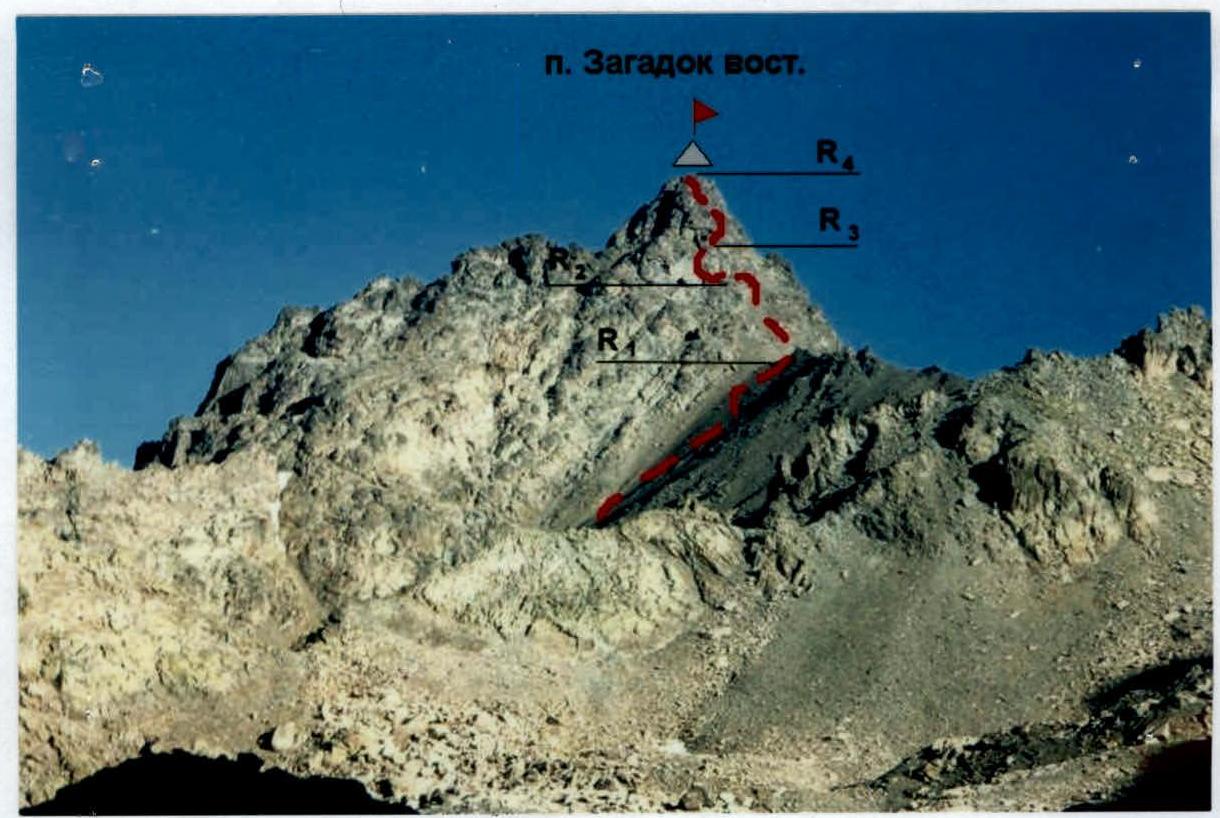 p. Zagadok East (3737 m) R4, II, 45°, 50 m
Recommendations
The route is logical and objectively safe, passable at any time of the year. The approach is convenient from the Zagadochnye campsite.
Only start the route in good weather. Recommended for training groups and sports teams. Plan the departure for 4:00–5:00.
The ridge is heavily destroyed — belaying to protrusions is problematic in some places due to the risk of dislodging them.
Since the Sugansky Ridge serves as a barrier to clouds moving from the Khares river valley, good visibility on the route is only ensured from the east and south sides.
There are many cracks on the route suitable for using chock stones such as:
- "friends"
- pitons (mainly channel-type)
For other types of chock stones, finding a suitable crack is less likely. Use belaying to protrusions on the ridge. Ice equipment is practically not used (except for crampons and ice axes in the initial part of the route in case of snow cover in the couloir). Descending slings will be needed.
Having 2 ropes of 50 m each is sufficient. This significantly simplifies the passage of key sections and rappelling.
The route is completed entirely in boots, without using special rock climbing footwear.
The route is recommended as the first for those starting to climb routes of 2B category of difficulty.