Fig.
7
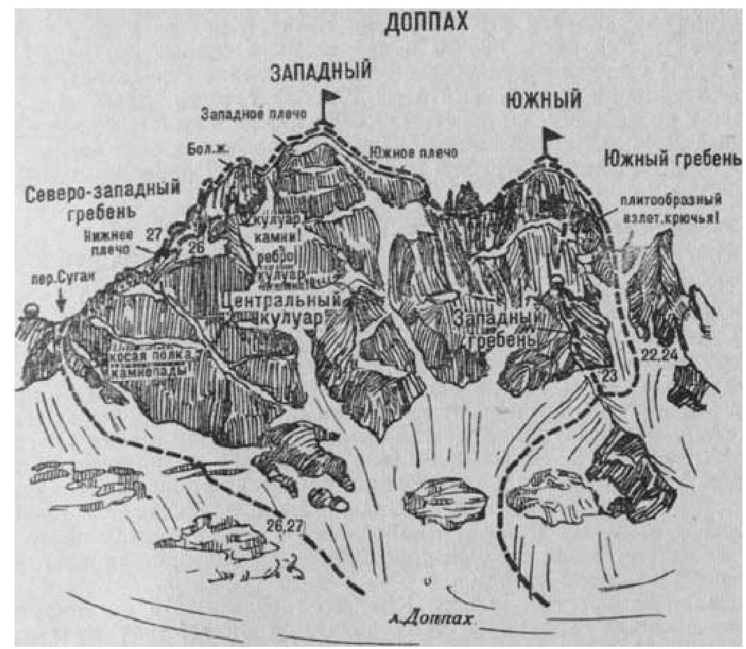
Fig. 8
- Western Doppakh via Southwestern slopes and Northwestern ridge (I. Suzhaev's combined route, category 4A, fig. 7, 8).
The path from the Nakhashbita meadow (group of 4-8 people) to the Doppakh glacier is described in route 22. On the right side of the glacier, approach a small steep lateral glacier descending onto the Doppakh glacier from the right, from under the Sugansky Pass located between:
- the Doppakh massif on the right
- Suganbashi on the left.
Here, turn right and, bypassing two small icefalls, ascend on the right side of the steep lateral, heavily crevassed glacier (stonefall possible from the Doppakh walls).
From the upper part of the lateral glacier - via a steep, narrow, and moderately difficult couloir (120-150 m) on the left of a wide, inclined, snow-covered shelf of the Doppakh massif, where stonefall is frequent. Ascent ("live" rocks - piton belay) to the Sugansky Pass. From the "Nakhashbita" meadow - 5-7 hours.
In a small cirque, 80-100 m left of the pass, under the Southeastern edge of the Suganbashi summit - initial bivouac.
From the bivouac:
- Cross the pass and reach the Northwestern ridge of the Western Doppakh summit.
- Ascent (piton belay) on the left side of the steep ice-and-snow slope of the Northwestern ridge.
- Further - along a 60-meter narrow ice-and-snow ridge.
- Then - 100-120 m right-up into a snow mulda.
- From the mulda - via a steep 30-35-meter ice wall (piton belay) to the "cushion" of the Northwestern ridge.
- From the cushion - along a steep ice-and-snow ridge-slope, ascent of 220-240 m (piton belay) to the lower shoulder of the Northwestern ridge.
From the Sugansky Pass - 3-4 hours.
From the shoulder, traverse 30 m right along a smooth, partially interrupted, above-average difficulty (piton belay), narrow rock shelf on the right side of the Northwestern ridge to a steep couloir.
Further:
- ascend 100-120 m (piton belay) along the steep ice slope of the couloir, along the edge of rocks and ice;
- higher, ascend rocks under the wall into which the couloir abuts;
- from here, traverse 30 m right along moderately difficult rocks to a steep, slab-like edge.
Then, along rocks of above-average difficulty, ascend the steep edge 90 m straight up (piton belay).
From under a giant slab:
- make a 30-40 m sport descent from the edge right along a smooth slab to a small snow platform under overhanging rocks.
- from the platform, traverse 15-20 m along a narrow rock shelf to the second deep, steep ice couloir.
- Then, traverse 40-45 m right-up, crossing the ice couloir (stonefall possible, piton belay) and reach an icy, wide, inclined rock shelf.
Having traversed 30 m along it, ascend 180-200 m straight up along steep rocks of moderate difficulty ("live" rocks) with ice sections to the snow saddle of the Northwestern ridge between the Big (Western) gendarme on the left and the summit tower of Western Doppakh on the right.
From the saddle:
- Turn right.
- Ascent of 100-120 m along a snow-covered, steep, wide rock Northwestern ridge to the Western shoulder.
- From the Western shoulder - along a wide snow ridge to the summit of Western Doppakh.
From the Sugansky Pass - 9-11 hours.
Descent along the Eastern ridge and southern couloir with a bivouac on the summit or near the saddle (see route 29). Duration of the route - 3 days.
Naumov A. F. Karaugom, Digoria, Tsey (Central Caucasus), M., "Fizkultura i sport", 1976.