Fig. 8
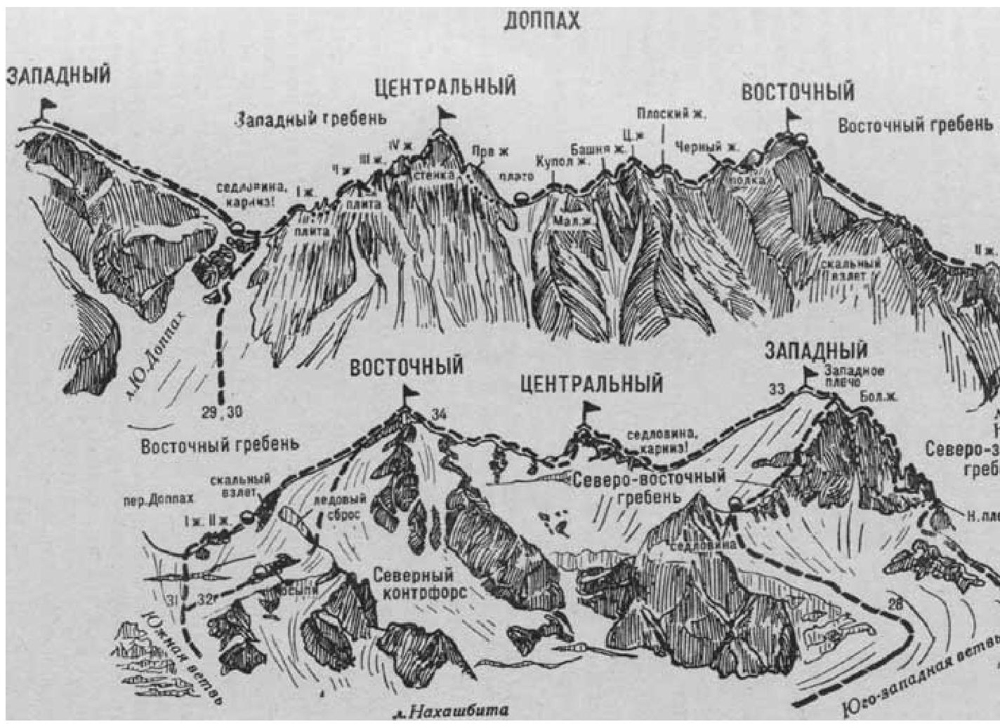
- Doppakh East via the North-Eastern Slope (combined route A. Zyuzin, cat. 4B, Fig. 8).
From the base camp on the right bank of the Psygan-su River, near the tongue of the Nakhashbita Glacier (group of 4-8 people), ascend via the crest of the left-bank moraine of the glacier to its end. Here, descend to the right onto the Nakhashbita Glacier and approach the serac zone of its Southern branch.
On the route:
- Ascend the powerful, steep, and heavily crevassed serac zone to the upper snow plateau leading to the Doppakh Pass.
- Traverse the plateau to the right and upwards onto the scree of the short Northern counterfort of the North-Eastern slope of the Eastern ridge of the Vostochny Doppakh peak.
The initial bivouac is on the scree. From the base camp, it takes 6-7 hours.
The approach path from the "Nakhashbita" meadow to the Doppakh Pass is described in route 17. From the pass, descend northwards down a steep ice-snow slope with an 8-10-meter sheer wall of the bergschrund in the lower part. Further, keeping to the left side of the Nakhashbita Glacier, it is necessary:
- to descend a steep slope with numerous crevasses;
- then, traverse a gentle, heavily crevassed upper part of the snow plateau to the left, onto the scree of the short North-Eastern counterfort of the North-Eastern slope of the Eastern ridge of the Vostochny Doppakh peak.
From the pass, it takes 2-3 hours. The initial bivouac is here.
From the bivouac, ascend via the scree and simple rocks of the Northern counterfort to the right side of a large ice fall of the hanging glacier on the North-Eastern slope of the Vostochny Doppakh. Traverse the ice fall to the right via a 35-50-meter ice wall (running belay).
Further:
- ascend a steep ice-snow North-Eastern slope,
- bypassing or overcoming numerous crevasses and steep sections,
- 700-800 meters ascent to the gentle part of the Eastern ridge,
- along the ridge - approach the summit pitch.
Bivouac here. From the initial bivouac on the scree, it takes 8-10 hours.
From here, overcome a small bergschrund and an 80-100-meter ice-snow slope, then ascend via the destroyed rocks of the Eastern ridge to the Vostochny Doppakh summit. From the bivouac, it takes 2-2.5 hours.
Descend via the ascent route or along the Eastern ridge (see route 31). The duration of the route is 3 days.
Naumov A. F. Karau gom, Digoriya, Tsey (Central Caucasus), M., "Fizkultura i sport", 1976.