Ascent Passport
- Class of technical ascents to the peaks of Digorsky gorge and nearby gorges of North Ossetia.
- Digoria. Eastern part of the Central Caucasus.
- Peak Galdor Glavny (4130 m) via the Southeast wall.
- 5B cat. sl. (approximately) first ascent.
- Height difference 1330 m. Length 900 m. Length of the wall section 380 m. Length of sections 4–5 cat. sl. 310 m. Length of sections 6 cat. sl. 20 m. Average steepness of the route.
- Pitons hammered: rock 10; ice 0; chocks 46.
- Team's working hours: 10 h, 2 days.
- Processing and overnight stay at the bivouac.
- Leader — Moiseev Alexander Anatolyevich, Master of Sports Participants:
- Fedorchenko Roman Viktorovich, 1st sports category
- Babaev Alexander Alexandrovich, 1st sports category
- Spinev Alexander Nikolaevich, 1st sports category
- Sokolov Alexander Vladimirovich, 1st sports category
- Berezhnaya Vera Nikolaevna, Candidate for Master of Sports
- Coach — Shandulin Vladimir Ivanovich.
- Processing — July 7, 1994. Work on the route — July 8, 1994, and descent to the bivouac. Return to base camp — July 9, 1994.
- Educational and sports center "Planeta" of the sports club of the plant
Brief Overview of the Ascent Area and Access Options
The object of the ascent — peak Galdor Glavny (4130 m), is located in the mountainous region of Digoria, in the eastern part of the Central Caucasus, in the central part of the Sugansky ridge, between the peaks of Botkin and Tsukhgarty. The area is well освоен by climbers (see A. F. Naumova "Karaugom, Digoria, Tsey"). Access to the ascent area is as follows:
- From the cities of Vladikavkaz, Nalchik to the village of Chikola.
- Further along the road up the gorge 4 km to the alpine camp "Digoria" of the "Rostselmash" plant. The approach to the route takes 6–7 hours of walking time. From the base camp up the road to its end (1.5 h), then along the trail to the farm (0.5 h), from the farm rise up to a small plateau and move in the direction of the ridge of peak Botkin, cross the river and, crossing the ridge, ascend to the lower Galdor bivouac. From here, up to the right along the ridge in the direction of a large couloir descending from the saddle between Middle and Small Galdor. The entire path from the farm to the upper Galdor bivouac takes 4 hours.
Tactical Actions of the Team
According to the tactical plan, on July 7, 1994, the group went out for processing, which was necessitated by the need for a faster passage of the route, as the weather in the Digorsky gorge area is extremely unstable and it is necessary to have some time reserve. 3.5 ropes were processed, further work was impossible due to the intensified rain.
On the next day, July 8, 1994, due to dense fog, the group started the route only at 7:00 am instead of the planned 4:00 am.
The key sections of the route were R5–R6, R6–R7. The first participant ascended in rock shoes, free climbing, on a UIAA rope, the other participants moved along the rope with top rope, or along double ropes with two jumar.
Team's nutrition: hot meals in the morning and evening. During the climb, each rope team had a dry ration. In addition, to quench thirst, each rope team had 1.0 l of water. There were no falls, injuries, or frostbite.
Throughout the route, the group used the "Bukashka Koshevnik-3" braking device to belay the first participant. The route is rockfall-prone, so for safety reasons, the "thread" of the route was chosen so that it passed away from the belay point.
The group maintained communication with the group at the Galdor bivouac and with the base camp. There were no radio communication disruptions. The rescue team was located at the base camp.
| Rock Pitons | Ice Pitons | Chocks | Route Diagram in UIAA Symbols | Section Number | Length, m | Steepness, ° | Difficulty Category |
|---|---|---|---|---|---|---|---|
| Total | |||||||
| 10 | 0 | 46 | |||||
| Team's Working Time | |||||||
| Total 10 h, active work 8 h | |||||||
| By Sections | |||||||
| R0–R1 | 400 | 35 | 2 | ||||
| 2 | R2–R3 | 40 | 60 | 3 | |||
| 3 | R3–R4 | 15 | 70 | 4 | |||
| 2 | R4–R5 | 10 | 80 | 5 | |||
| 3 | R5–R6 | ||||||
| 2 | R6–R7 | 25 | 85 | 5 | |||
| R7–R8 | 15 | 25 | 2 | ||||
| 3 | R8–R9 | 10 | 70 | 4 | |||
| 5 | R9–R10 | 20 | 80 | 5 | |||
| 4 | R10–R11 | 20 | 85 | 4 | |||
| 2 | R11–R12 | 10 | 80 | 4 | |||
| 7 | R12–R13 | 20 | 75 | 5 | |||
| 5 | R13–R14 | 20 | 75 | 5 | |||
| 2 | R14–R15 | 20 | 75 | 5 | |||
| 6 | R15–R16 | 20 | 95 | 6 | |||
| 1 | R16–R17 | 10 | 70 | 4 | |||
| 3 | R17–R18 | 5 | 65 | 5 | |||
| 1 | R18–R19 | 5 | 20 | 1 | |||
| 3 | R19–R20 | 30 | 65 | 4 | |||
| 1 | R20–R21 | 10 | 70 | 4 | |||
| R21–R22 | 40 | 70 | 5 | ||||
| 2 | R22–R23 | 20 | 70 | 4 | |||
| R23–R24 | 120 | 40 | 3 |
Route Description by Sections
R0–R1 Snow-ice couloir. R1–R2 Snow-ice slope, approach to the start of the rock section. R2–R3 Medium complexity section (system of alternating ledges, rocks are heavily destroyed). R3–R4 Inner corner with seepage ice and a small number of holds, protection via chocks, leads to a small ledge. R4–R5 Steep complex wall with small holds, protection via chocks. Move in the direction of two cracks. R5–R6 Up the left directly to its middle, here is the belay station, protection via pitons. R6–R7 Traverse left and straight up the steep wall with small holds, protection via pitons. R7–R8 Large ledge at the base of a large crack. R8–R9 Wall with a small number of holds, hanging belay station, protection via pitons. R9–R10 From here, traverse right into an inner corner, closed at the top by a plug. Good cracks for chocks. Leads to a small ledge. R10–R11 From the ledge up the steep inner corner. Holds are good, but many "live" stones. Protection via chocks. Leads to a small ledge. Here is a good belay station. R11–R12 Along the steep wall in the direction of a large inner corner. R12–R13 Approach the inner corner along a small ledge and along the right part of the inner corner with a transition in the upper part to the left part to exit onto a ledge, good belay station via a protrusion. Protection via chocks. R13–R15 Wall with "ram's foreheads" type rocks, sloping holds, small chocks are used for protection. Straight up in the direction of an overhanging chimney, and then left traverse through a large crack, up the crack going left, ascend to the edge of a large crack. Protection via pitons and chocks. R15–R16 Along the wall up a ice-filled crack 15 m, and then move left to an overhang and straight up to a ledge. Key section of the route. R16–R17 Inner corner with good holds. R17–R18 System of ledges and inner corners with good holds. Protection via chocks. R18–R19 Large rock ledge. R19–R20 Smooth inner corner. Protection via large chocks. R20–R21 Inner corner with good holds. Hanging belay station. R21–R22 Wall with good holds. Belay points are difficult to organize, as there are few cracks. Protection via pitons. R22–R23 Same rock terrain as on the previous section. Exit to the ridge. R23–R24 Narrow rock ridge. Protection via protrusions.
Photo 3. Approach to the start of the wall. Section R0–R1. July 7, 1994. Camera "Smena". Shooting point 3.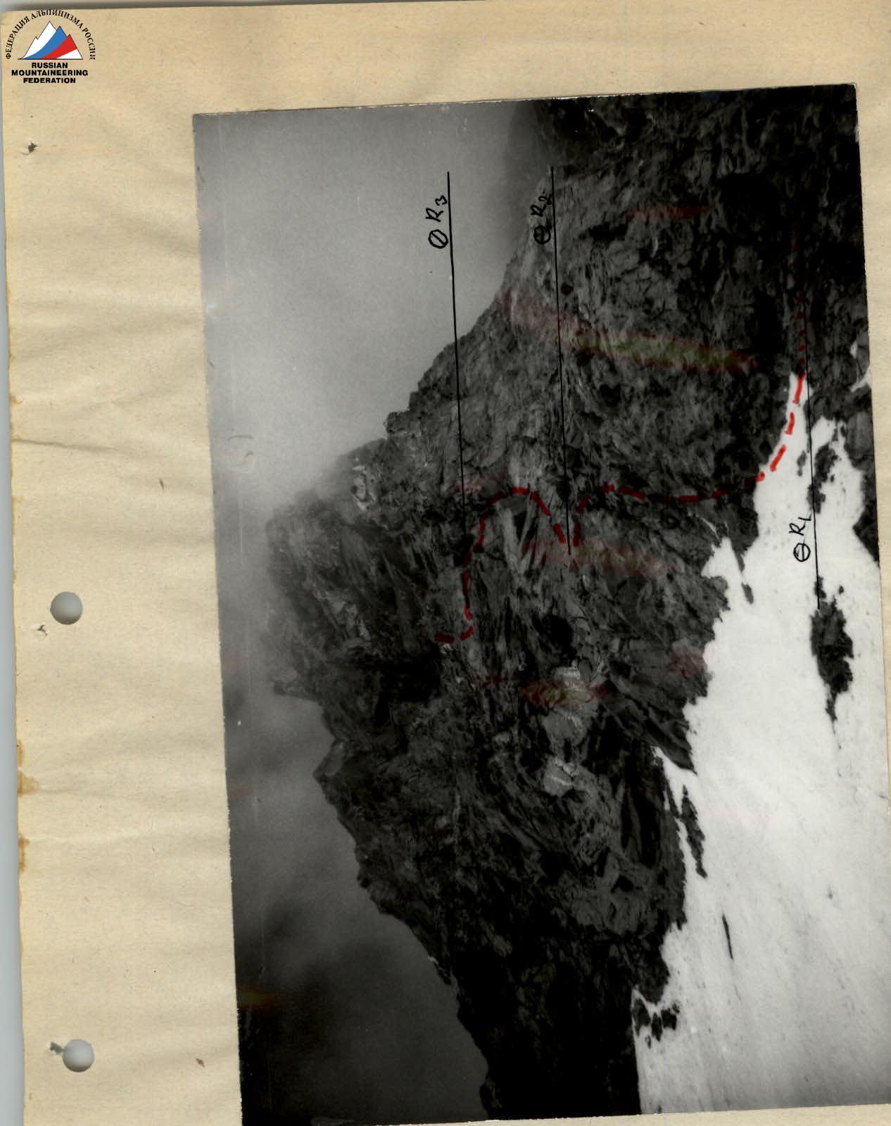
Photo 4. Start of the wall. Sections R1–R2, R2–R3. July 7, 1994. Camera "Smena". Shooting point 4.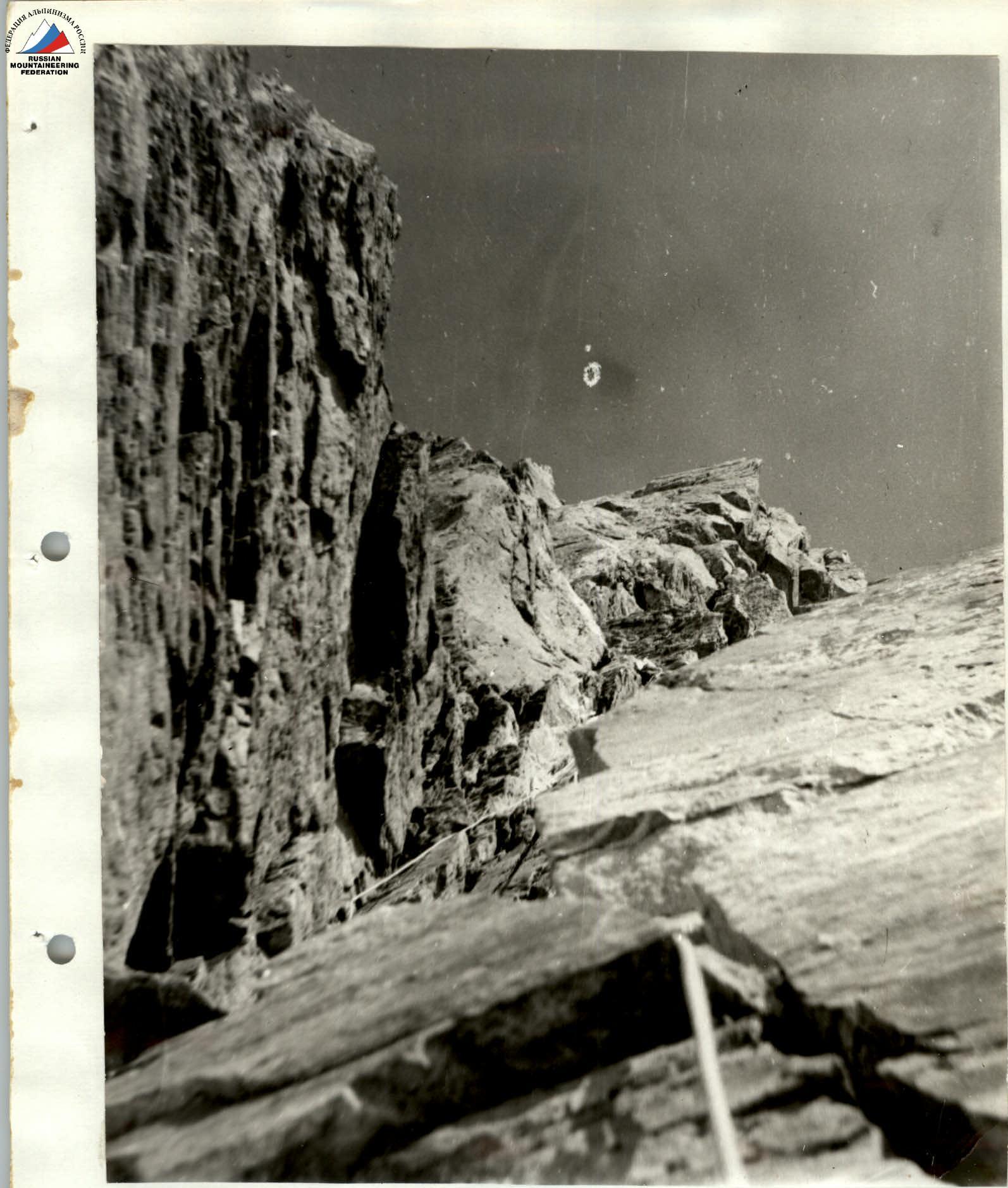
Photo 8. Section R11–R12. July 7, 1994. Camera "Smena". Shooting point 6.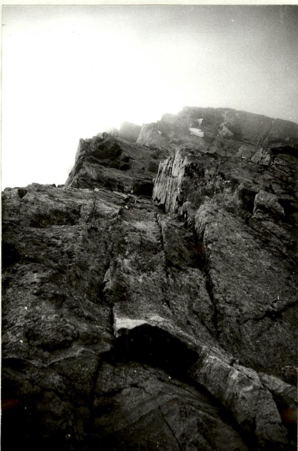
Photo 9. Section R13–R14. July 8, 1994. Camera "Smena". Shooting point 9.
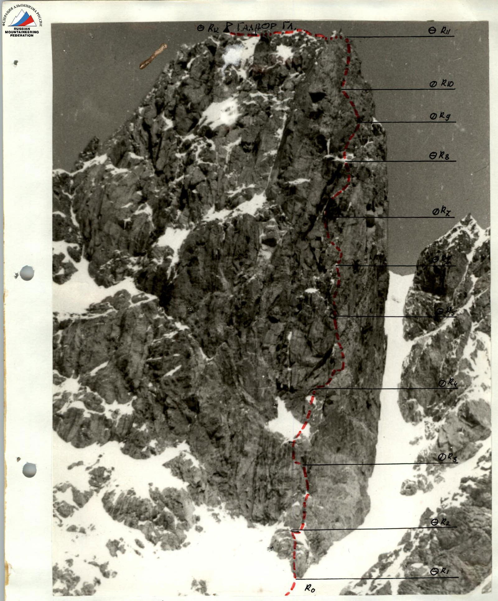 Photo 2/21. Profile of the wall on the right. July 7, 1994. 15:00. Camera "Smena". Shooting point 2. 2.2. Technical photo of the route.