Ascent Passport
-
Ascent class: rock climbing.
-
Ascent area: Caucasus, Gebidon river valley, 2.6.
-
Peak, route: Abduramanova (3250 m), North ridge.
-
Expected category of difficulty: 2A rock, p/p
-
Route characteristics: Height difference — about 300 m
Route length — 500–600 m; Length of sections: 3rd category of difficulty — 80 m; 2nd category of difficulty — 180 m, average steepness of the main part of the route — 45°
- Belaying through ledges, rock pitons.
- Number of walking hours/days — 5–6/1
- Number of overnight stays: 1 — at a bivouac.
- Leader and coach: Yu. V. Levkovsky — Candidate Master of Sports
Participants: 3 people.
- Departure to the route from the bivouac: August 24, 2006
Return to the bivouac: August 24, 2006
- Organization: DSAT
"Digoria".
 w.
Abduramanova from the north-west
w.
Abduramanova from the north-west
Brief overview of the ascent area, peak
The peak R. Abduramanova is located in the Gebidon river valley, at the end of the northern spur of the Main Caucasian Range in Western Digoria.
To the south, the peak is bounded by the Kороткий pass (3172 m), beyond which lies the massif of v. Rostselmash.
To the north, a long and steep rocky ridge descends.
The western slopes of the peak descend into the Gebidon river valley with the Gebe glacier.
To the east, the path through the Afsanau pass (3065 m) leads to the Bartuy glacier.
The massif of the peak is composed of schists and granites, broken in the lower part, monolithic in the upper part. To the west and east, steep narrow scree couloirs descend from the massif, filled with snow.
The peak is named after Abduramanov Rustem Umarovich, a well-known geologist and alpinist, researcher of alpine routes in North Ossetia.
Preparation for the ascent
In preparation for the ascent, available materials were studied in the card catalog of DSAT "Digoria", determining:
- the location of the peak,
- preliminary assessment of the route,
- path to the approach and bivouac site,
- principle of ensuring radio communication.
Description of the approach
The approach to the overnight stays, located in the upper reaches of the Gebidon river valley, begins from DSAT "Digoria". The movement goes down the road, past the "Digoria — Rostselmash" base, to a large stationary metal bridge over the Khares river (3 km).
After crossing the bridge over the Khares river and then overcoming the turbulent stream of this river via a temporary bridge or fording, one reaches the trail. A clearly marked trail leads through the Taymazi clearing, descending beyond it into the Tanadon riverbed.
Further movement proceeds:
- in the riverbed along its right bank (100 m),
- then along the trail, sometimes going through the forest along the riverbank.
250–300 meters beyond the confluence of the Tanadon and Gebidon rivers, the trail steeply rises to the left up the slope in a dense forest. From the bridge over the Khares river — 1.5–2 hours.
After 20–30 minutes, the trail leads to a wide, forest-free hillock, where a convenient rest is possible.
Further, the trail:
- steeply climbs the slope,
- gradually goes to the right up through the grass,
- crosses deep narrow gullies with small streams high above the Gebidon river,
- leads to a wide couloir descending from the slopes of v. 300-letiya Sankt-Peterburga.
In the couloir, a stream with clear water flows — a convenient place for a rest. From the start of the ascent — 1 hour.
The trail, steeply rising from the couloir, traverses to a small valley, overgrown with dense tall grass and littered with large stones. Nearby, the Gebidon river waterfall descends.
Beyond the valley, the trail again steeply rises to the left up the grassy slope, higher going to the right to a wide scree groove with a stream. The forest thins out and ends. Ahead, two grassy ascents are visible, leading to the upper reaches of the Gebidon river.
After passing the groove, the trail goes along the right bank of the river, initially gently, then — more steeply — rising along the grassy ascents, beyond which the gorge turns into a wide valley, overgrown with grass.
In the upper part of the valley, the peaks of Rostselmash and Gebe rise, to the left a wide couloir leads to the Afsanau pass. Here, to the right of the stream, there are convenient grassy areas for a bivouac. Height 2600 m above sea level.
These are the warm lower overnight stays, the upper ones — higher, on the moraines of the Gebe glacier, 1 hour walk away.
To the left of the stream, behind the moraine, a small lake is located, the water level of which depends on the amount of snow and moisture in the valley. In the summer period, it dries up.
From DSAT "Digoria" 5–6 hours.
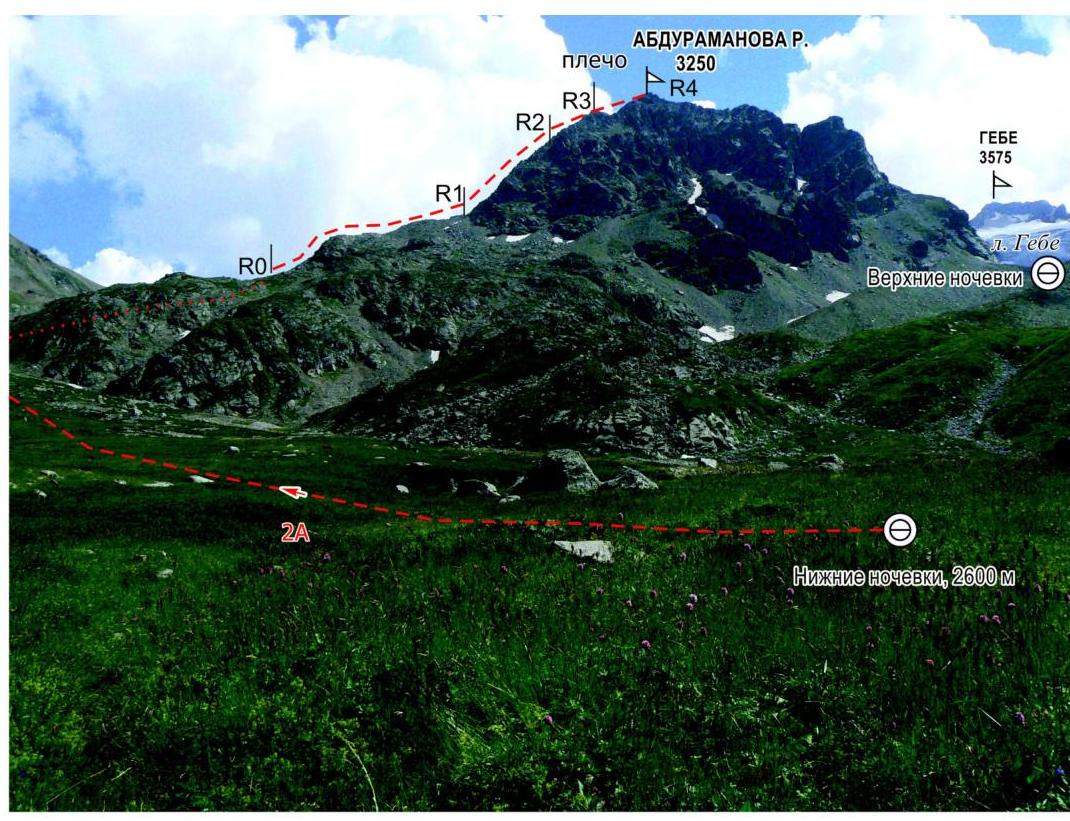
Description of the route
The approach to the route begins from the lower overnight stays in the upper reaches of the Gebidon river valley. From the initial bivouac, we follow the clearly marked trail in the valley, leading to the Afsanau pass. Bypassing the massif of Abduramanova R. from the north, turning to the right, we ascend along the gentle grassy-scree slopes to the beginning of the North ridge, from the east (1.5–2 hours).
Bypass and ascent:
- Bypassing the beginning of the North ridge from the left (in the direction of travel), we come out onto a wide steep grassy slope.
- We move to the right up the slope under the sheer smooth rock, coming out onto a narrow saddle in the North ridge.
- Turning to the left, we approach along the несложным скалам гребня (250–300 м) к взлёту.
Ascent to the взлёт:
- We pass along steep rocks (2–2+ category of difficulty, 50°, 60–80 m).
- Further, we ascend along steep rocks of the ridge, in the upper part overcoming a wall (the entire section 3 category of difficulty, 50–60°, 20 m), coming out onto the shoulder of the взлёт.
Final section:
- We ascend to the peak of Abduramanova R. along steep rocky ledges and rocks.
From the initial bivouac — 4–5
hours.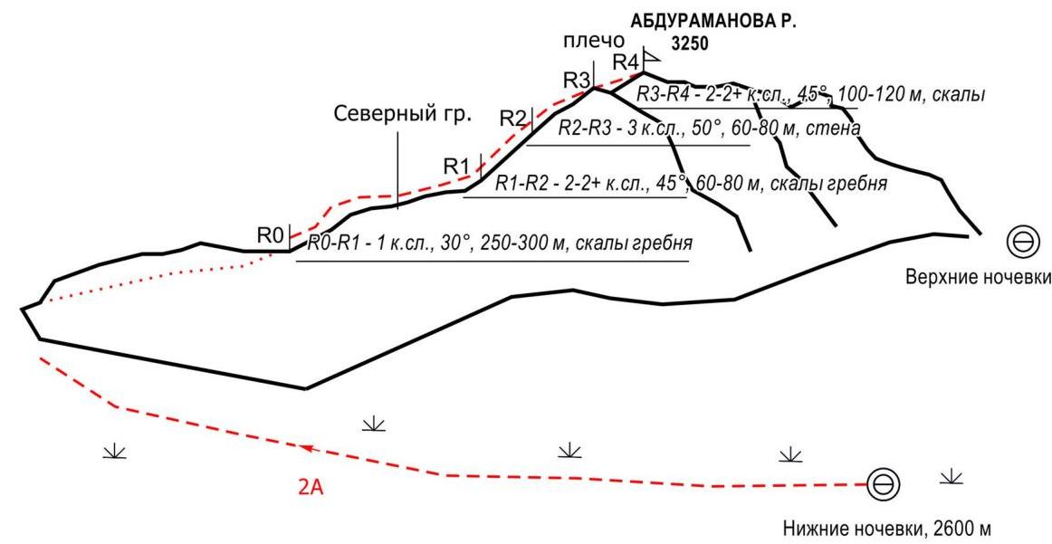
Scheme of the route Abduramanova R. 2A category of difficulty
ridge. w.
Abduramanova from the
east
w.
Abduramanova from the
east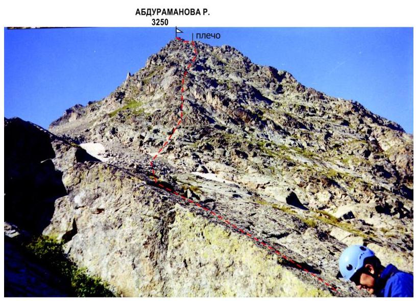
Abduramanova R. North
ridge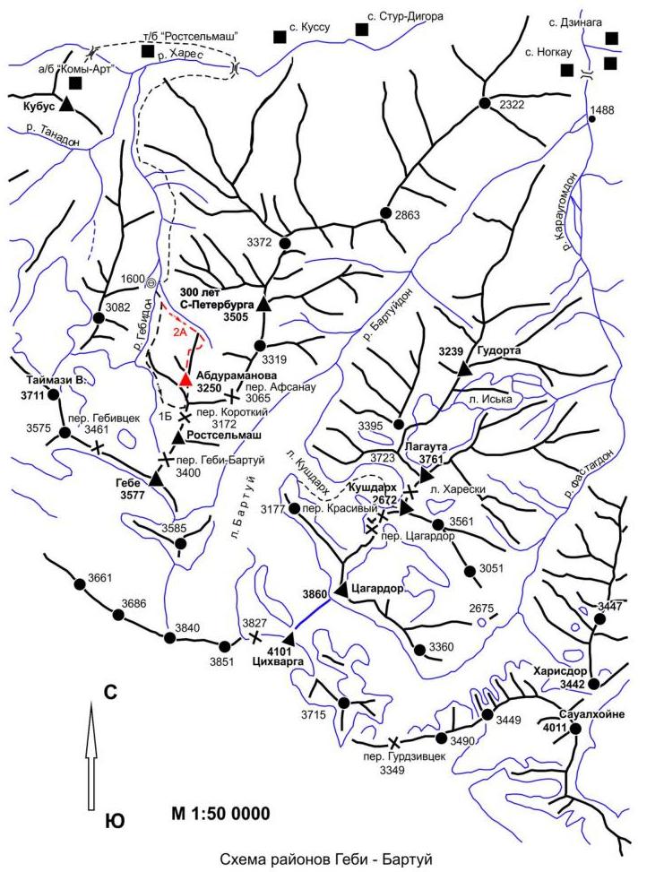
Recommendations
- The route is logical, objectively safe, passable at any time of the year.
- Belaying on the route through ledges, rock pitons.
- Recommended for passage by training, sports groups.
- Descent is possible to the west, 40 m south of the peak, down a narrow scree couloir, leading slightly above the upper overnight stays.
- Belaying in the couloir through an ice axe.