Ascent Passport
- Ascent category: rock.
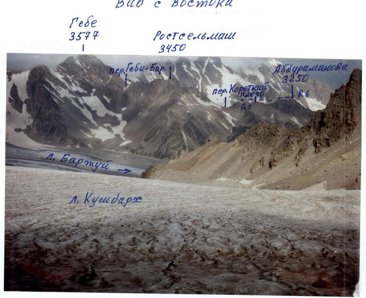
- Ascent area: Caucasus, Gebidon river gorge, 2.6.
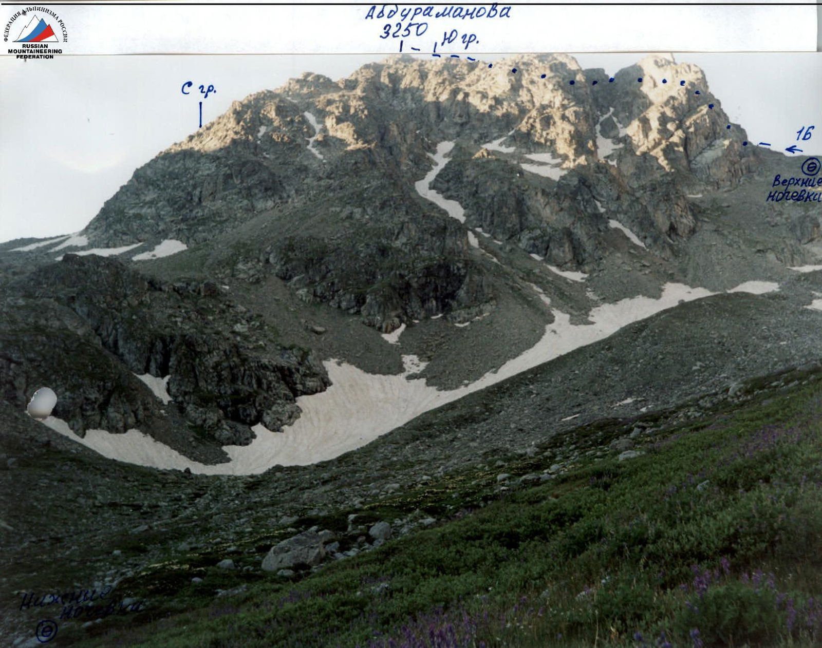
- Peak, route: Abduramanova (3250 m), South ridge.
- Expected difficulty category: 1B rock, p/p
- Route characteristics:
Height difference — about 80 m. Route length — 320 m. Section lengths: 3rd difficulty category – 20 m 2nd difficulty category – 180 m average steepness of the main part of the route — 45°
- Belaying through ledges.
- Number of climbing hours/days — 4–5/1
- Number of overnight stays: 1 — at a bivouac.
- Leader: Yu. V. Levkovsky — Candidate Master of Sports
Team members: A. I. Gorbunov — 2nd sports category
- Coach: Levkovsky Yuri Vasilyevich, Candidate Master of Sports.
- Departure to the route from the bivouac: July 24, 2005.
Return to the bivouac: July 24, 2005.
- Organization: AUSV "Digoria".
Taken from Kushdarh (3400 m). View from the east. F. 1

R0–R1 — 1st difficulty category; 45°–50°; 50 m; grassy slope with rock outcrops. R1–R2 — 2nd difficulty category; 45°; 40 m; rocks. R2–R3 — 2nd difficulty category; 45°; 50 m; rock ledges. R3–R4 — 3rd difficulty category; 50°; 20 m; wall. R4–R5 — 2+ difficulty category; 45°; 40 m; rock ledges. R5–R6 — 2nd difficulty category; 45°; 50 m; grassy slope with rock outcrops.
fig. v. Abduramanova; 1B rock; South ridge.
Route Description
The approach to the route begins from the upper overnight stays in the upper reaches of the Gebidon river gorge. The movement goes on a traverse along a snowy gentle slope in the direction of Gebi-Bartuy pass. After 250–300 m, there is a turn to the left and an ascent to the beginning of the scree couloir descending from under Kороткий pass. The path goes up along the gentle scree on the right side of the couloir, along the stream, leading to a wide snow-scree circus. Further, there is an ascent along a gentle (20°–30°) snowfield with an exit to the second stage of the circus. Turning to the left, there is a transition from snow to a scree slope, along which the ascent leads to the counterfort of the South ridge of v. Abduramanova. The scree counterfort with simple rocks leads to a scree shoulder in the South ridge. From the upper overnight stays, 2 hours.
The first pillar is bypassed on the right along a steep grassy-rock slope with an exit to a narrow isthmus above the pillar.
The second pillar is overcome along simple rocks.
The third pillar is bypassed on the left along rock ledges with an exit to the right onto the South ridge.
Further follows:
- descent along rocks of the wall of medium complexity with good holds to a narrow isthmus;
- bypassing the fourth pillar from the left side along rocks of medium complexity;
- ascent along a steep grassy-scree slope, leading under the tower of the peak;
- ascent to the tower on the right along rock-scree ledges.
From the scree shoulder in the South ridge, 2–3 hours.
Brief Overview of the Ascent Area, Peak
The peak R. Abduramanova is located in the Gebidon river gorge, at the end of the northern spur of the Main Caucasian Ridge. From the south, the peak is bounded by Kороткий pass (3172 m), behind which the massif of v. Rostselmash begins. To the north, a long and steep rocky ridge descends. To the west, the upper reaches of the Gebidon river gorge with l. Gebi stretch, to the east, Avsanau pass (3065 m) leads to l. Bartuy.
The massif of the peak is composed of schists and granites, destroyed in the lower part, and monolithic in the upper part. To the west and east, steep narrow scree couloirs descend from the massif, filled with snow.
The peak is named after Rustem Umarovich Abduramanov, a well-known geologist-alpinist, researcher of alpinist routes in North Ossetia.
Approach Description
The approach to the overnight stays, located in the upper reaches of the Gebidon river gorge, begins from AUSV "Digoria". The movement goes down the road, past the "Digoria-Rostselmash" base, to a large stationary metal bridge over the Khares river (3 km).
After crossing the Khares river by the bridge and then overcoming the turbulent stream of this river by a temporary bridge or fording, there is an exit to the trail. A clearly marked trail leads through Taymazi clearing, descending behind it into the bed of the Tanadon river. Further movement passes:
- in the riverbed along its right bank (100 m),
- then along the trail, sometimes going through the forest along the river bank.
250–300 m behind the confluence of the Tanadon and Gebidon rivers, the trail steeply rises to the left up the slope in a dense forest. From the bridge over the Khares river, 1.5–2 hours.
After 20–30 minutes, the trail leads to a wide, free from forest hillock, on which a convenient halt is possible.
Further, the trail again steeply climbs up the slope, gradually going on a traverse to the right. Crossing deep narrow gullies with small streams high above the Gebidon river, it leads to a wide couloir descending from the slopes of v. 300th anniversary of St. Petersburg.
In the couloir, a stream with clear water flows, here is a convenient place for a halt. From the beginning of the ascent, 1 hour.
The trail, steeply rising from the couloir, leads on a traverse to a small valley, overgrown with dense tall grass and littered with large stones. Nearby, a waterfall of the Gebidon river descends.
Behind the valley, the trail again steeply rises to the left up the grassy slope, higher going to the right to a wide scree gully with a stream. The forest thins out and ends.
Ahead, two grassy ascents are visible, leading to the upper reaches of the Gebidon river.
Bypassing the gully, the trail goes along the right bank of the river, initially gently, then more steeply rising along the grassy ascents, behind which the gorge turns into a wide valley overgrown with grass.
In the upper part of the valley:
- The peaks Rostselmash and Gebe rise
- To the left, a wide couloir goes to Avsanau pass
- To the right of the stream, there are convenient areas for a bivouac
Height 2600 m above sea level.
Overnight stays:
- Warm lower ones — here
- Upper ones — higher, on the moraines of l. Gebe, in 1 hour of walking
To the left of the stream, behind the moraine, there is a small lake, the water level of which depends on the amount of snow and moisture in the valley. In the summer, it dries up.
From AUSV "Digoria", 5–6 hours.
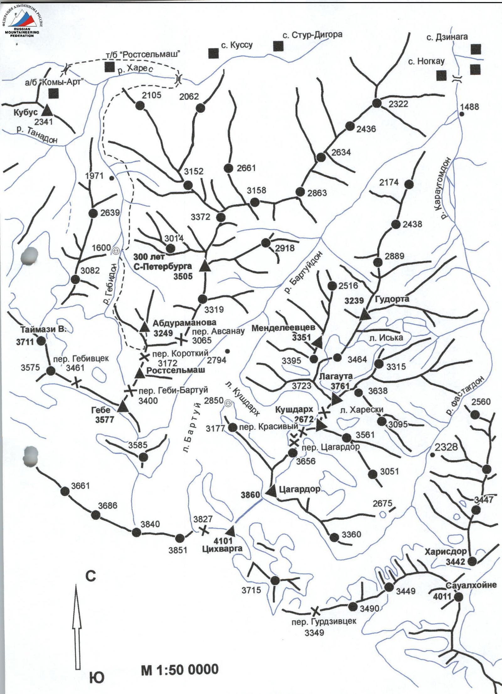
Map of the Gebi – Bartuy area.
View from the northwest (1600 m). F. 2
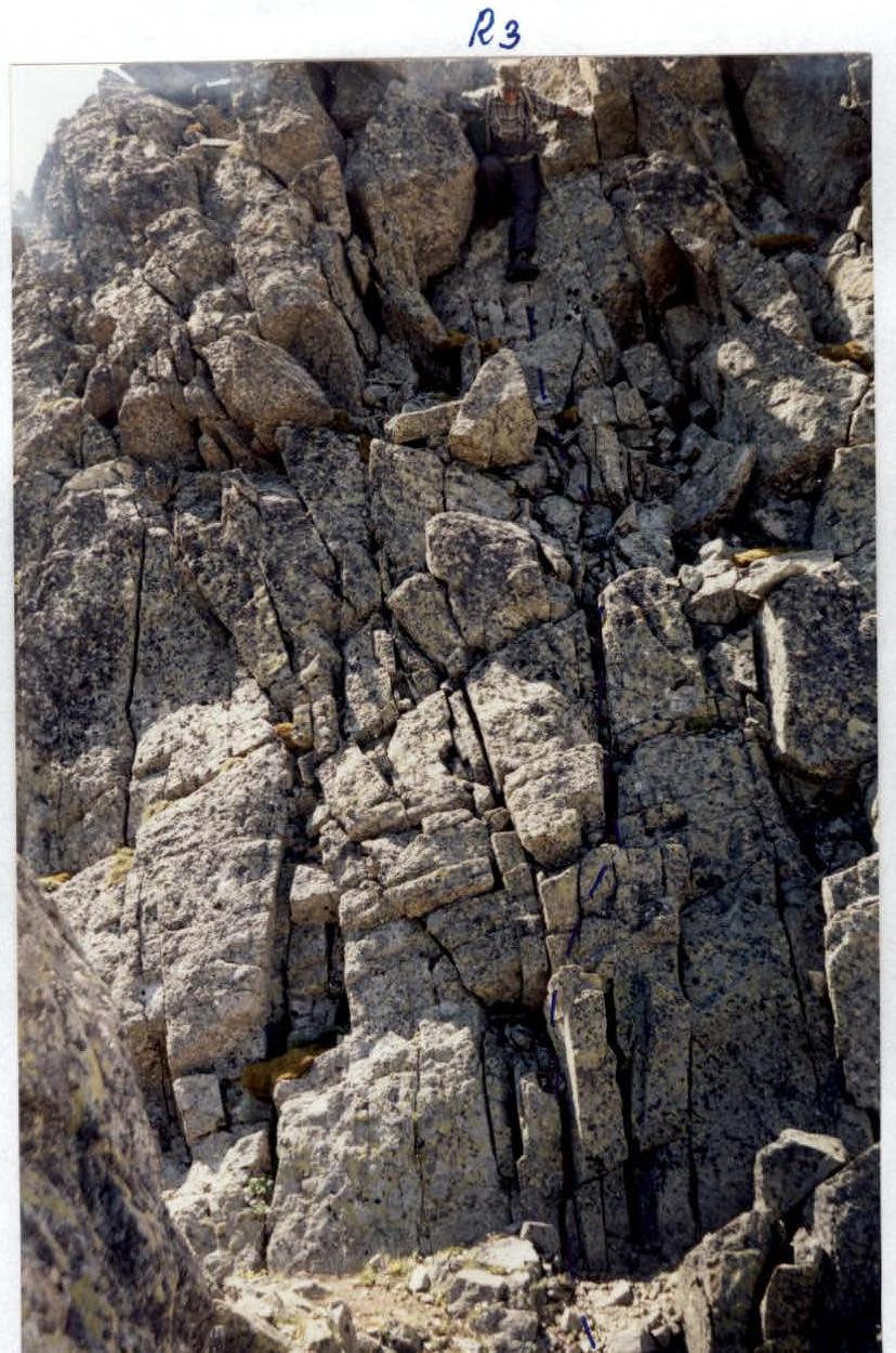
Section R3–R4
F. 3