- Climbing area: Central Caucasus, Lateral Ridge, Krumkol glacier valley. KMGV section number: 2.5
- Peak: 4443 via the Southwest couloir and Northwest ridge.
- Category of complexity: proposed 4A category, first ascent.
- Route character: combined.
- Height difference: about 1000 m.
- Route length: about 1500 m, including:
- length of rock sections IV — 25 m,
- rock sections III — 45 m,
- ice sections with a slope of at least 40° — 200 m.
- Number of pitons used:
- ice screws — 4,
- chocks (including "frenzy") — 12,
- tape loops — 10.
- Number of climbing hours: to the summit — 10 hours, descent via the ascent route — 5 hours.
- Number of bivouacs — 0 (one-day route).
- Team composition:
| Name | Qualification |
|---|---|
| Anisimov N.B. | 1st sports category |
| Kaluzhsky S.N. | 1st sports category |
| Torubarин A.Y. | 2nd sports category |
| Kolchinskaya E.E. | 2nd sports category |
- Team coach: Shibaev S.A., Candidate Master of Sports
- Departure to the route — July 21, 2004 at 5:30,
reaching the summit — July 21, 2004 at 15:30,
descent to the glacier — July 21, 2004 at 21:00 (return to base camp — 21:40).

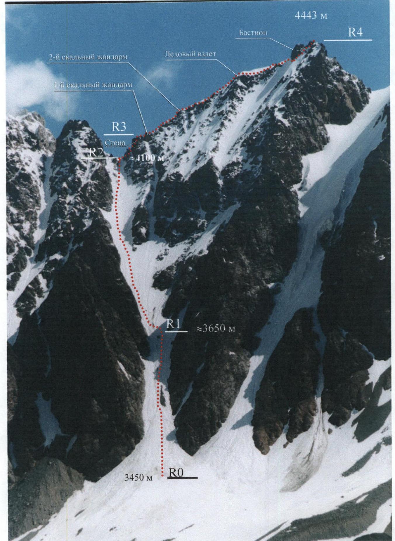
Fig. 1. Route thread and division into sections
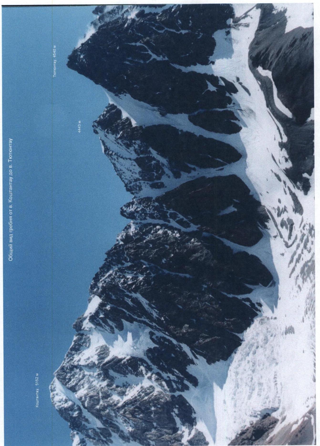
Fig. 2. General view of the "4443" peak in the Koshtantau – Tyutyunta peaks ridge
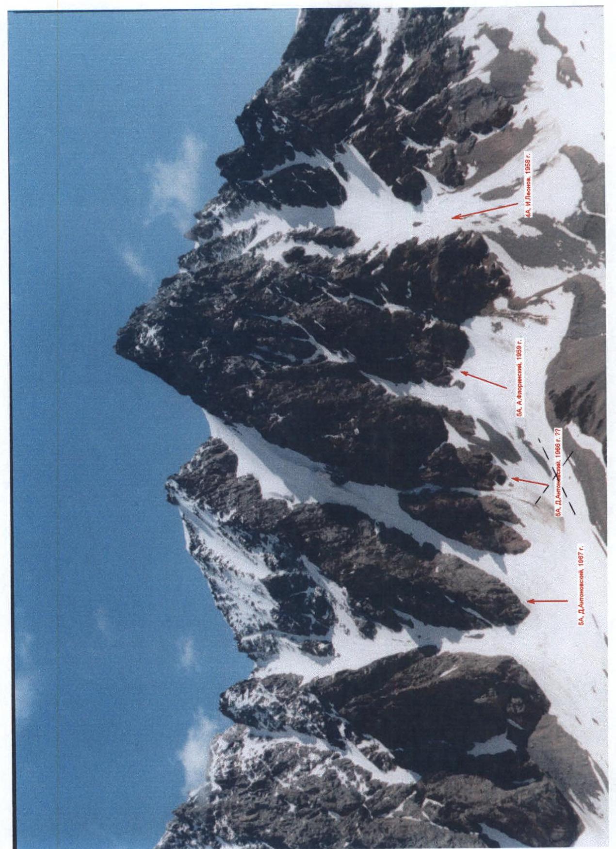
Fig. 3. Known routes on Tyutyun-tau and 4443
Climbing area map
(Extract from the map «Scheme of mutual arrangement of peaks and passes of the Greater Caucasus. K-38-27-V. Bezengi Glacier»)
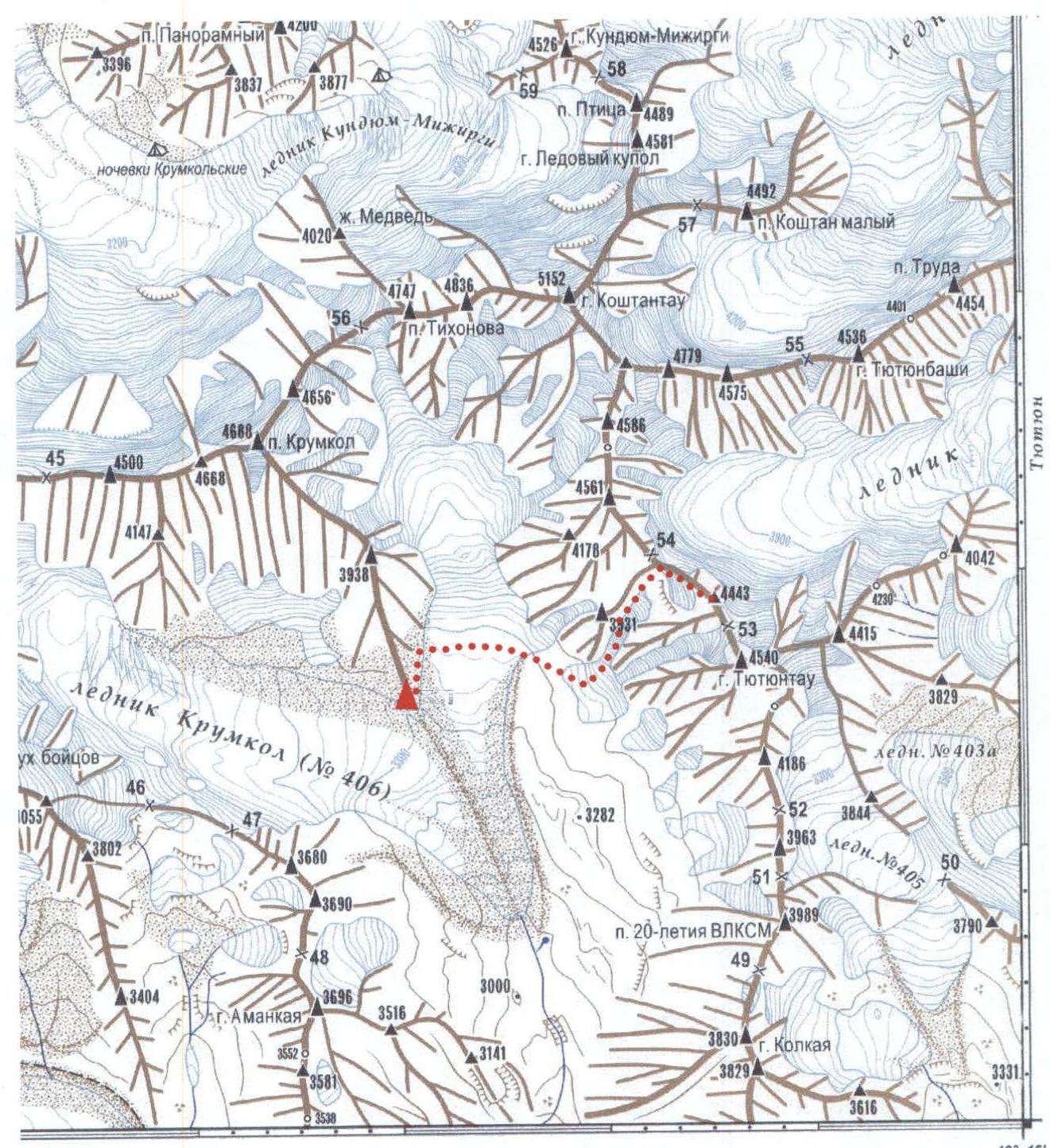
Magnetic declination east 5° 39′ © Geographical basis. VTU GS MO USSR 1966–1970 © Scheme compilation, field survey. V.G. Lyapin 2003
The scheme is made on the basis and with the accuracy of a topographic map with a scale of 1:100 000. Updates, clarifications and additions were made using:
- Landsat7 and MK-4 satellite images,
- Aster and SRTM radar sounding data,
- tourist scheme edition of 1993.
Additional load is given according to the materials of tourist and mountaineering expeditions and events. Glacier numbers are given according to the "Catalog of glaciers of the USSR" editions 1967–1977. Partially surveyed in the field in 2000–2003.
Fig. 4
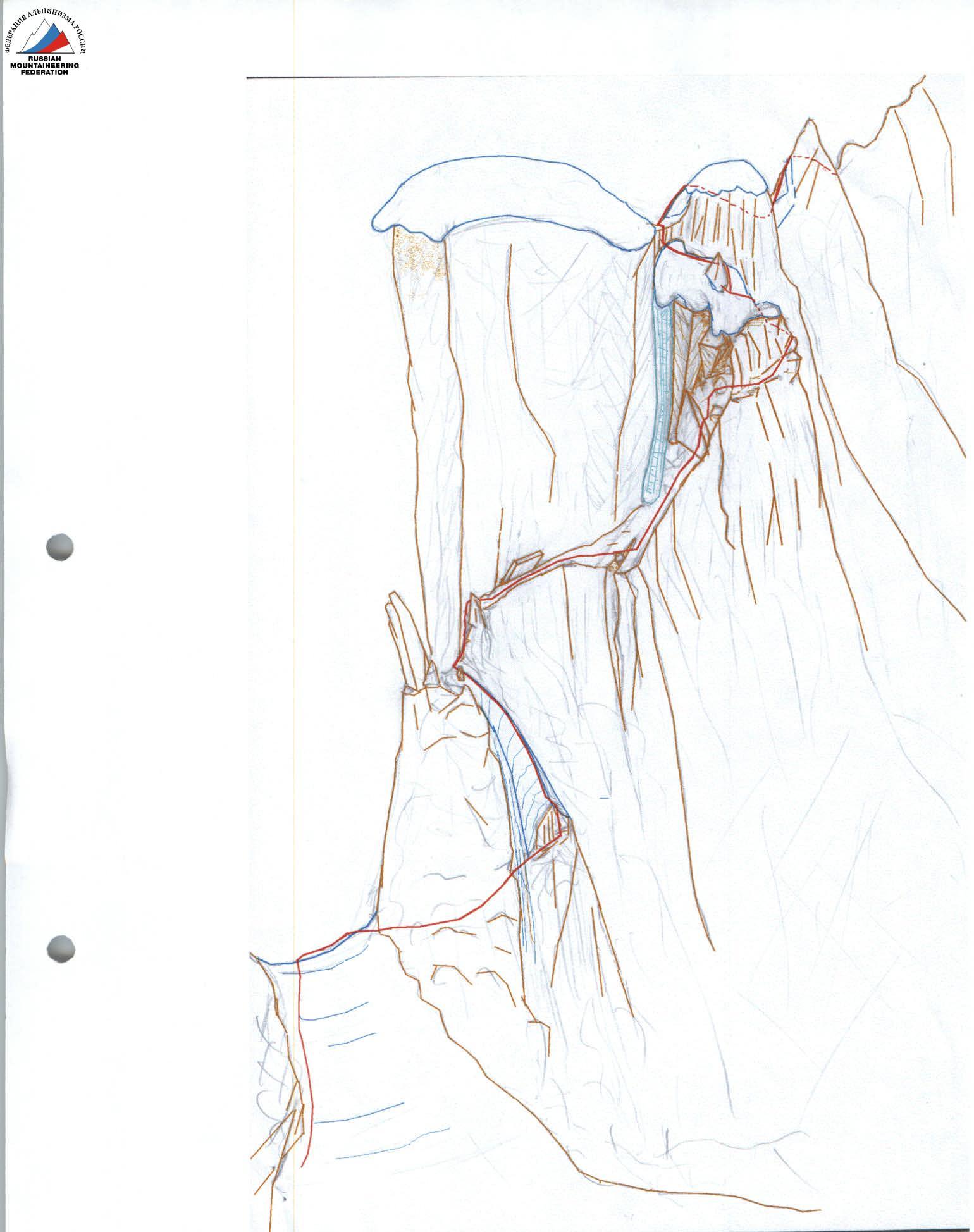
Fig. 5. Key point of the route — exit to the NW ridge
ROUTE SCHEME IN UIAA SYMBOLS

Brief description of the route
The route description is given from the base camp located on the moraine under the SE ridge of Krukol peak at the confluence of the right and left branches of the Krumkol glacier. The transition to the base camp from the Bezengi alpine base takes at least 2 days:
- On the first day — to the Janghi-kosh hut (with heavy backpacks 8–9 hours);
- On the second day — through the Kamnepadniy pass and Spartak pass to the upper reaches of the Krumkol glacier (8–9 hours) and further down the closed Krumkol glacier to the moraine under the SE ridge of Krukol peak (3–5 hours, depending on the presence of fog). In this case, cargo delivery by the shuttle method took 5 days.
Base camp — start of the route. From the base camp:
- descent from the moraine to the left (orographically) branch of the Krumkol glacier
- crossing perpendicular to the glacier flow
- exit to the route — to the Southwest couloir of the Northwest ridge of the "4443" peak (from the camp 40 minutes)
In poor visibility, a good landmark for finding the start of the route is a large stone scree from the neighboring rocky couloir, located approximately 100 m to the left of the start of the route.
Section R0–R1: — lower part of the couloir. Up the avalanche cone with a slope of 25° about 100 m. Then 150 m along the snowy slope with a slope of 30–35°:
- to the left of rock outcrops
- to the right of avalanche gullies
- straight up to a large separate stone in the middle of the couloir. Movement is simultaneous, on hard (in the morning) snow with crampons.
Section R1–R2: middle and upper parts of the couloir. Above the stone, move to the left side of the couloir and along the avalanche gullies 500 m along the ice-snow slope with a slope of 40° ( местами 45°) to the saddle in the ridge.
Movement in rope teams is mostly simultaneous, sometimes alternating, with insurance through an ice axe (under a thin layer of snow — a layer of fragile ice, which can be broken through with an ice axe, under it firn).
In the morning, the snow is hard throughout the height of the couloir, except for the last 100 m near the ridge, where under the crust there is a layer of loose snow.
Exit to the saddle along the right boundary of rocky islands in the upper part of the couloir.
The saddle is located between:
- the 4250 m peak on the left (according to Naumov — Trapezia gendarme)
- the ridge ascent on the right.
From the start of the route to the saddle — 4 hours.
Section R2–R3 — rocky ascent (see Fig. 5). The Northwest ridge of the 4443 m peak drops to the saddle with a sheer wall about 80 m high. Exit to the ridge along the ledges on the right side of the wall.
At the beginning from the saddle, traverse to the right 15 m along rocky ledges (chocks, tape loops, climbing of medium difficulty), then through a snowy gully to a rocky outcrop, from which an acute snowy ridge goes up, with a slope of 45°. Along the acute snowy ridge about 20 m up to the exit to the saddle between the wall and a large separate rocky "wing". Rappel. Insurance for rocky outcrops. Be careful, on the saddle there is a snowy cornice!
Further 3 m up the crevice between the wall and the acute rocky outcrop — exit to a narrow horizontal ledge. Along the ledge 8 m, passing under a granite slab of correct rectangular shape 2.5×1.5 m inclined over the ledge (be careful, do not load the slab!) — exit to a wide inclined (45°) icy and snowy ledge (insurance: chocks, friends, loops).
Along the right edge of the ledge, increasing in steepness and turning into a wall, leaving the ice-filled inner corner on the left, 15 m up, under an overhang (icy rocks, insurance). Further, two variants of exit to the snowy ledge located above are possible:
- The first — passage of the overhanging section (about 2.5–3 m) head-on with the help of artificial climbing aids and a ladder;
- The second — bypassing the rocky tower on the right and exiting to the snowy ledge from the opposite side (difficult climbing).
Further on the inclined snowy ledge, insurance for a large acute rocky outcrop. Rappel. Then 8–10 m up the snowy slope to a vertical rocky wall 2 m high and along it — exit to the ridge (insurance). From the saddle to the exit to the ridge 1.5–2.5 hours (depending on the group's qualification).
Section R3–R4 — Northwest ridge to the summit. Along the ridge to the summit about 650 m. Average steepness of the ridge 25°. Movement in rope teams is simultaneous, except for some sections.
Throughout the ridge:
- Large snowy cornices on the left
- Two rocky gendarmes and one icy ascent
Rocky gendarmes are passed head-on. Rocks of medium difficulty, height of rocky sections up to 6–8 m, steepness 60°. Icy ascent 10–12 m, steepness about 50° (ice screws).
At the end of the ridge — a rocky bastion, which is bypassed on the right. The last section of the ridge before the bastion: 40 m traverse of a snowy-icy slope with a slope of 45°. Movement is alternating with insurance through ice screws.
Bypass of the rocky bastion to the right along a convenient snowy-icy ledge, bordering the bastion from the west and south (insurance for rocks, chocks, loops). At the end of the ledge on the south side of the bastion — a convenient insurance spot, protected from above by a rocky outcrop.
Further:
- 50 m along an icy-snowy slope 45–50° and simple destroyed rocks to the summit tower (insurance for rocky outcrops with the help of loops, rappel)
- 15 m along simple rocks — exit to the summit
From the exit to the ridge to the summit — 3 hours 30 minutes (from the start of the route to the summit — 9–10 hours).
Descent along the ascent route 5 hours. On the descent route, there are three rappels:
- one from the summit (can be done in a sports style)
- two rappels from the ridge to the descent couloir.
When descending from the ridge, first descend to the snowy slope — ledge to a large acute outcrop, for which to secure the first rappel rope (rappel loop not less than 3 m). Descent in the direction of the rocky "wing". Be careful, oblique rappel! In case of leaving the ledges, it is possible to hang on the vertical wall. Have jammers ready for lifting along the rope!
The second rappel — from the saddle from the rocky "wing" straight down 40 m to the main couloir (without entering the saddle).
Further down the couloir simultaneously (in the upper half of the couloir on the steepest short sections — descent facing the slope on the front points of crampons).
Note: according to observations the day before the ascent and during the ascent and descent along the southwest couloir, no rockfall was recorded.
As an alternative descent route, it is possible to descend from the summit towards Tyutyunta peak to the saddle and further to the right down the icy-snowy couloir. It should be borne in mind that:
- In the middle of the height of the couloir, there is an icy drop, which is bypassed on the right along the way.
- Below the drop, one should strictly adhere to the right side of the couloir.
- In the lower part of the couloir, possible ice avalanches from this drop pose a threat.
Recommendations for subsequent groups
- Start working on the route at dawn (no later than 5:30).
- Equipment for a group of 4 people:
- main ropes: 2×50 m;
- expendable rope: 8 m;
- carabiners: 8 pcs.;
- crampons: 4 pairs;
- ice axes: 4 pcs.;
- ice screws: 4 pcs.;
- chocks: 1 set + tape loops 6 pcs. or rock pitons — 10 pcs. and hammer (as preferred);
- personal equipment (helmets, harnesses, self-arrest gear, jammers, descenders, carabiners) — 4 sets;
- headlamps — 4 pcs.;
- first aid kit;
- water flasks and "dry rations" — for each participant.
Comparative assessment of the route's category of complexity
The group members have experience of ascents in the Bezengi area on the following combined routes of 3B–4A category:
- Ural Vostochny via the E wall through the saddle, 4A category;
- 4310 via the NE ridge, 3B category;
- Ural Maly via the E ridge, 3B category.
The considered route to the 4443 peak via the Southwest couloir and Northwest ridge:
- in terms of the complexity of rocky sections is not inferior to the first of the above-mentioned routes and surpasses the second and third;
- in terms of the maximum steepness of icy and snowy-icy sections is somewhat inferior to the first of the mentioned routes and is not inferior to the second and third;
- in terms of the overall length of the route is comparable to the second of the mentioned routes and surpasses the first and third.
In addition, the existing route in the classifier of 4A category on the nearby Tyutyunta peak does not seem more complex than the considered route to the 4443 peak by description and visually.
Based on the above comparison, we consider that the route to the 4443 peak via the Southwest couloir and Northwest ridge corresponds to 4A category (combined).
Note:
At the summit, a note was found from a group of climbers from the LOK DSO "Trud" (led by D. Antonovsky), from which it follows that the group, having left the glacier on July 7, 1967, was at the summit on July 9, 1967 at 14:00 and, as written in the note: "made the first (unreadable) ascent to the North Tyutyun-tau peak via the western buttress from the Krumkol glacier, approximately 5th (unreadable) category".
This somewhat does not coincide with the KMGV, where it is stated: "Tyutyunta peak via the left SW edge, 5A, D. Antonovsky, 1966" (see Fig. 3).