Ascent Record
- Category — snow and ice climb
- Main Caucasus Range, Bezengi valley
- Shkhara Main via the ice board on the North face
- Proposed — 5B category difficulty, first ascent
- Height difference — 1800 m, length — 2790 m, length of sections with IV–VI category difficulty — 888 m, including about 130 m of VI category difficulty. Average steepness of main sections — 44°
- Equipment used on the route:
ice screws — 197, rock pitons — 4
- Climbing hours for ascent — 24, days — 1.5
- All overnight stays on snow platforms
- Team leader: Bushmanov Yu.D., Candidate for Master of Sports
Team members:
- Maleev B.V., Master of Sports
- Nekrasov A.O., Candidate for Master of Sports
- Panasyuk V.M., Candidate for Master of Sports
- Coach: Suponitsky M.V.
- Departure to the route: August 10, 1985
Summit: August 11, 1985. Return: August 12, 1985
Preparation for the Ascent
The Leningrad team for the USSR Championship was formed based on three societies:
- Locomotive Sports Society of the October Railway — lead organization;
- SCA-5;
- Spartak Sports Society.
In 1984, Locomotive Sports Society conducted a 20-day training camp in the Bezengi area, which ended with an ascent of Krumkol peak, 6B category difficulty, as part of the Leningrad Championship (2nd place).
Direct preparation began in Leningrad after the announcement of the USSR Championship area for the ice and snow class by the Sports Committee of the USSR. Photographic materials were studied, consultations were held with participants of ascents on the Bezengi wall routes, and special equipment was manufactured and improved.
For candidates to the national team, individual training plans were drawn up, including:
- general physical training in sports halls, sanatoriums, and suburbs of Leningrad;
- special training on the "Svetlana" and Leningrad State University walls;
- ice training in the Sabline area;
- rock climbing training on the rocks of Vyborg, Kuznechnoe, and Impilakhti.
To monitor general physical and special training, candidates for the national team participated in control competitions organized by the city alpine federation and the Locomotive Sports Society of the October Railway.
When determining possible ascent routes within the USSR Championship, the route to Main Shkhara via the ice board on the North face was considered.
The basis of the team's tactical actions on the routes was:
- Night and early departures;
- Intensive and mostly autonomous work of rope teams on extended ice sections, requiring good physical and ice climbing skills;
- Non-contact interaction between rope teams;
- Manufacturing of extended ice screws to ensure safety while moving on loose ice.
From July 12 to 31, 1985, a training camp was conducted before the USSR Championship in the Adyl-Su area. Before the camp started, all team members went through an acclimatization period in the Caucasus or Pamir mountains. The training plan approved by the Leningrad Alpine Federation was completed, except for the ascent to a peak of 5B category difficulty due to the area being closed (there is a certificate from the Elbrus region KSP), and the team members successfully passed control standards for physical and technical training.
Serious attention was paid to selecting food products during preparation for the USSR Championship.
Ascent Schedule
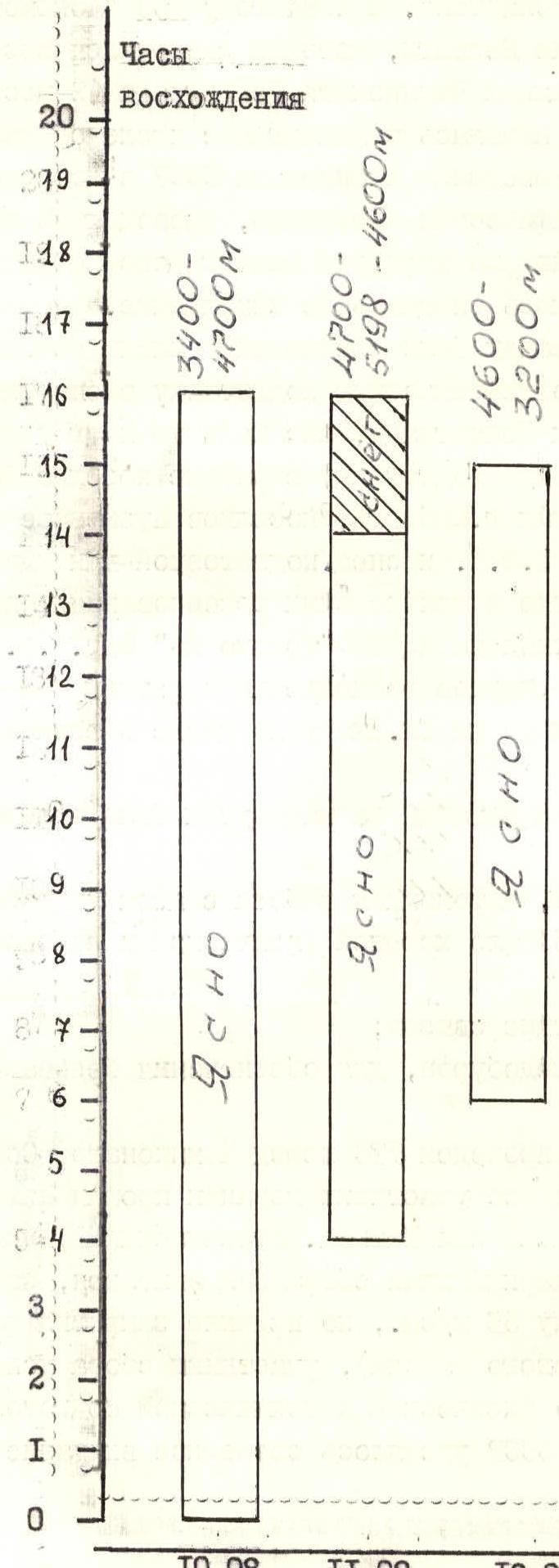
Time of reaching the summit — 2 hours 40 minutes on August 11, 1985.
1st overnight stay in a tent on snow, a convenient crevice before the pillow of the 2nd ice fall. 2nd overnight stay in a tent on snow, convenient, on the ridge after the East summit.
Tactical actions of the team:
- The route to Main Shkhara via the ice board on the North face was climbed by the Leningrad team as part of the USSR Championship in the snow and ice class.
- August 9, 1985 — departure from the Bezengi alpine camp, approach to the route, and viewing the route through binoculars.
- August 10, 1985 — departure at 00:00, setting up camp for the night at 16:30.
- August 11, 1985 — departure from the overnight stay at 4:00, reaching the summit at 11:40, setting up camp for the night on the NE ridge at 16:15.
- August 12, 1985 — departure from the overnight stay at 6:00, descent to Janghi-kosh at 15:00, return to the Bezengi alpine camp at 19:30.
The movement pattern changed depending on the terrain. Sections with IV–V category difficulty were climbed by independent rope teams, with the second team using pitons screwed in by the first team, which allowed reducing the piton stock compared to working with parallel rope teams.
Sections with VI category difficulty (R1–R2, R9–R10, R12–R13) with a total length of 40 m were climbed with fixed ropes.
Snow sections with II–III category difficulty were climbed simultaneously.
Simultaneous movement of rope teams on a full rope length was allowed on certain ice sections with at least three intermediate pitons.
Rope teams: Bushmanov — Nekrasov, Maleev — Panasyuk. Leading teams were switched every 10–12 ropes, so all team members worked as leaders.
The very early departure was due to the need to reach the highest possible altitude on the first day and to safely pass objectively dangerous sections in the dark and early morning.
The tactical plan for the ascent was fully executed by the team. This tactics and intensity of movement allowed the team to cover the ice slope with a height difference of 1300 m in 14 hours on August 10, 1985.
During the ascent, modern equipment was widely used:
- crampons on a rigid platform;
- "ice-fis";
- ice screws 180 mm long.
The first overnight stay was organized in a crevice of the 2nd ice fall, as further movement was not safe due to poor snow conditions. The second overnight stay was on a ridge. Both overnight stays were convenient.
Throughout the ascent, the group maintained stable communication with observers using "Kaktus" radios. There were no falls or injuries during the ascent.
| Ice Pitons | Rock Pitons | Route Diagram | Category, avg. steepness, length | Time | Section № |
|---|---|---|---|---|---|
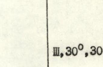
| 10 | - |  | III, 40°, 200 m | 3:00 | R4 |
| 18 | - |  | VI, 90°, 90 m | R3 | |
| 6 | - |  | V, 45°, 60 m | R2 | |
| 5 | - |  | VI, 75°, 15 m | R1 | |
| 5 | - |  | IV, 40°, 210 m | 12:00 | R0 |
| 90 | - | V, 45°, 650 m | R5 | ||
| 8 | - | V, 60°, 40 m | 14:00 | R9 | |
| 20 | - | IV, 45°, 220 m | R8 | ||
| 18 | - | V+, 55°, 180 m | 3:00 | R7 | |
| 3 | - | –V, 50°, 30 m | R6 | ||
| 90 | - | V, 45°, 650 m | R6 | ||
| - | - | IV, 40°, 260 m | 5:00 | R16 | |
| - | - | II, 20°, 170 m | R15 | ||
| 6 | - | IV, 45°, 60 m | R14 | ||
| - | - | Reaching the summit — 11:40. 16 climbing hours. Total on the ascent — 191 ice screws. | II, 20°, 30 m | 6:00 | R13 |
| 2 | - | VI, 90°, 3 m | R12 | ||
| 6 | - | V, 50°, 30 m | R11 | ||
| 5 | - | VI, 80°, 20 m | 10:00 | R10 | |
| - | - | Reaching the summit — 11:40. Total on the ascent — 197 ice screws. | IV, 45°, 50 m | 10:00 | R18 |
| - | - | Scale 1:3000 | III, 30°, 300 m | R17 |

Section R5–R6. Snow slope with a small steepness. Rope teams move simultaneously, the second team follows the tracks of the first. Change of lead.
Section R6–R7. Crossing the bergschrund. Ice slope, piton belay. Independent movement of rope teams.
Section R7–R8. Snow slope with loose deep snow, breaks in the ice dome of the summit filled with snow. Simultaneous movement of rope teams, change of lead in the group. Exit to the ridge into a snow mulde.
Section R8–R9. Traverse of a snow and ice slope with an exit to the rocks of the summit. Independent movement of rope teams, alternate. Belay from rock outcrops on the leeward side.
Route Description by Sections
- Section R0–R1: represents a system of ice couloirs leading under the ice barrier.
- The lower bergschrund was crossed via a snow and ice outwash, then through one of the couloirs with piton belay to the right under a "chimney" in the rocks filled with ice.
Section R1–R2. "Ladder" 15 m long was climbed with piton belay by the first rope team, then the second team followed via the fixed ropes.
Ice:
- apple ice;
- climbing is very difficult.
Section R2–R3. Movement across rocks resembling "lamb's brows" covered with ice to the base of the ice barrier. Piton belay, independent movement of rope teams.
Section R3–R4. Traverse along the base of the ice barrier to the right. "Ice-fis" are used for progression, piton belay, independent movement of rope teams. Very hard ice in some places.
Section R4–R7. Ice board, less steep in the lower part after crossing the ice barrier with a layer of granular snow 10–15 cm deep, then the steepness increases as it approaches the rock island.
Crossing the second bergschrund via a bridge. Independent movement of rope teams, using pitons left by the first team.
Section R7–R8. Crossing the rock island via one of the ice gullies dissecting it. Some areas have bare apple ice. Piton belay, independent movement of rope teams.
Section R8–R9. Ice slope, transition to the right side of the gully leading from the second ice barrier. Movement along the rocks on the right side of the gully. Piton belay, independent movement of rope teams. Near the base of the barrier, there is a large layer of dense snow on an ice substrate.
Section R9–R12. Exit to the base of the barrier with a traverse to the right. Very hard ice among rocks resembling "lamb's brows". Very difficult climbing using "ice-fis", the second team ascends via fixed ropes. Ascent up a steep ice wall into a gap behind a standalone serak. Very hard ice.
Section R12–R13. Exit into a snow and ice pocket with standalone ice blocks, overcoming an ice and snow plug. Piton belay, movement of the second team via fixed ropes.
Section R13–R14. Snow mulde under the wall of the second barrier. The overnight stay is convenient and safe. The wall of the second barrier provides protection from potential avalanches.
Section R14–R15. Crossing the wall of the second barrier with a traverse to the left, along a shoulder that forms an ice ledge on the second barrier. Piton belay, independent movement of rope teams.
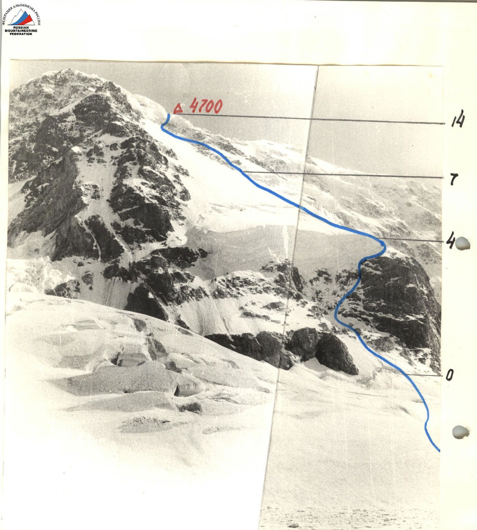
Photo 3. Profile of the wall on the left. Taken from the overnight stays under the wall, 1985, object I-50, focal length — 5 cm.
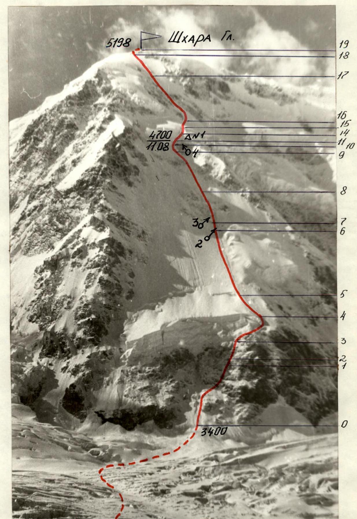
Technical photo of the route. Taken on August 9, 1985, from the moraine of the Bezengi glacier. Shooting point №7, 3400 m, distance — 1.65 km. Lens T-43, focal length 40 mm.
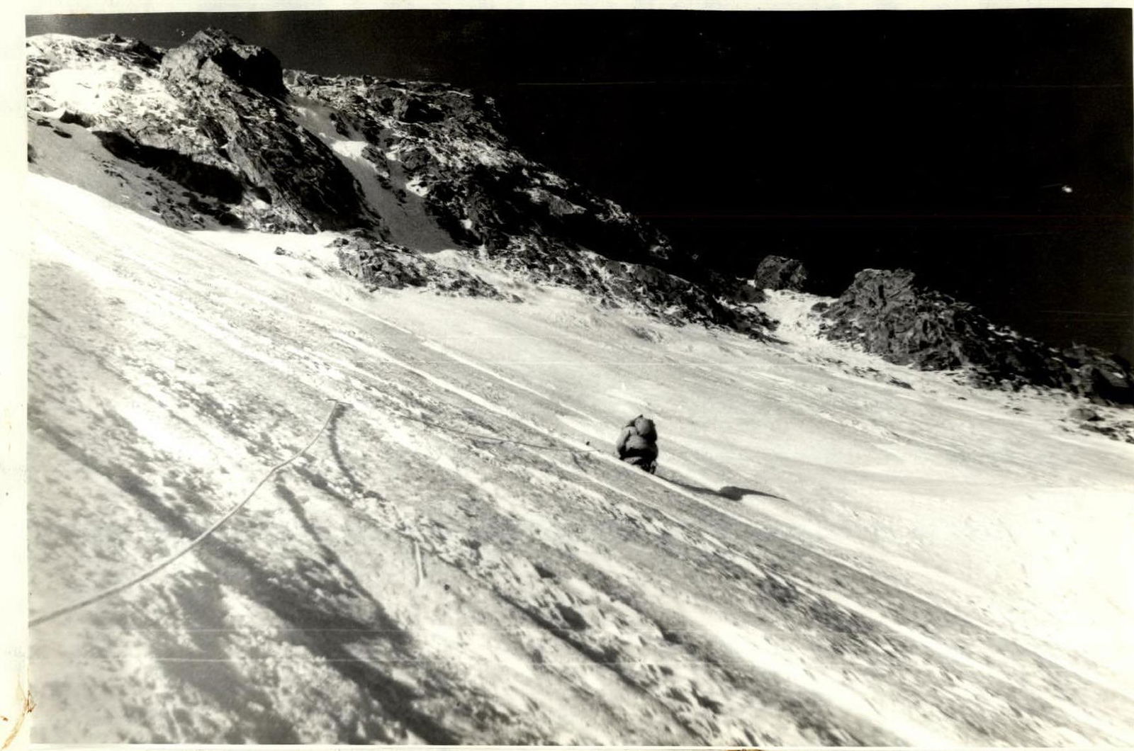
Photo №2. Crossing the ice board under the rock island. Taken on August 10, 1985, at 7:00. Lens T-43, focal length 40 mm.

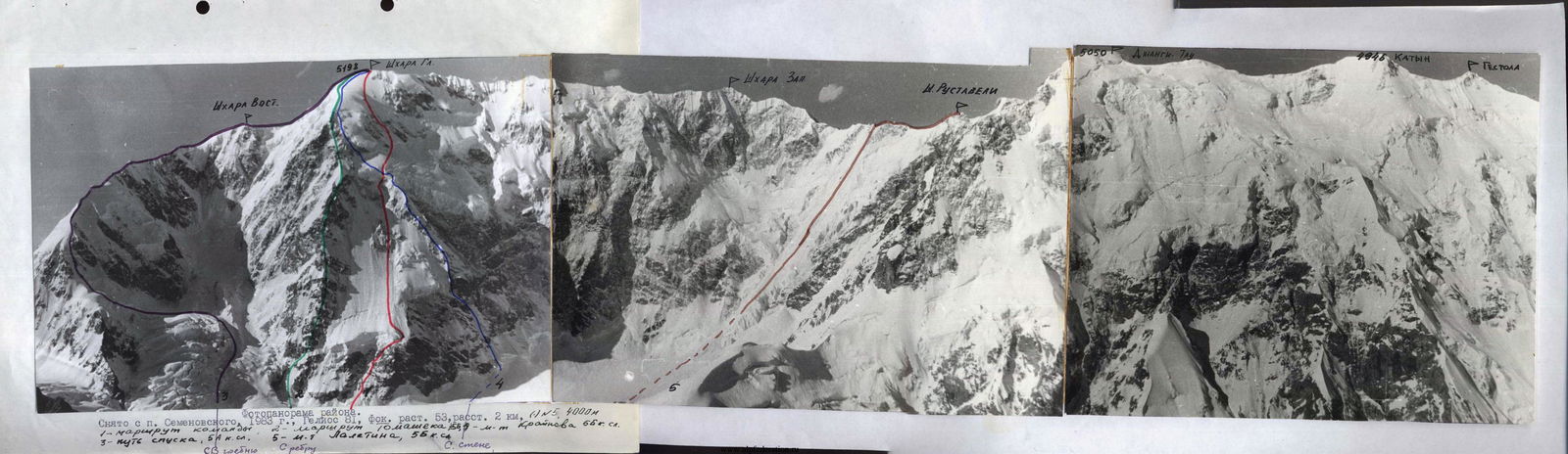
Taken from v. Sh. Rustaveli, 1983, Helios 81, focal length 53, distance 2 km.
Not saved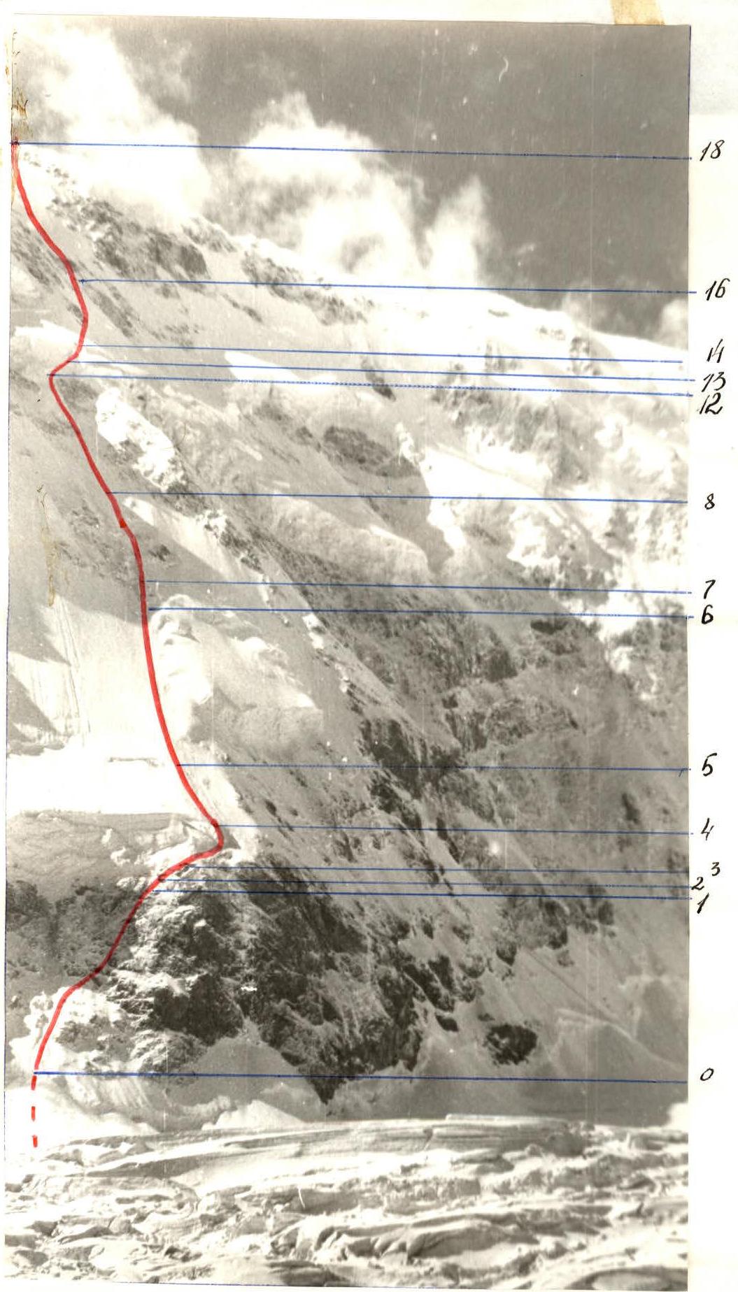
Profile of the wall on the left. Taken: Moraine of the Bezengi glacier, August 9, 1985, 3400 m, distance 1–1.5 km, Lens T-45, focal length 40 mm, Shooting point №3.
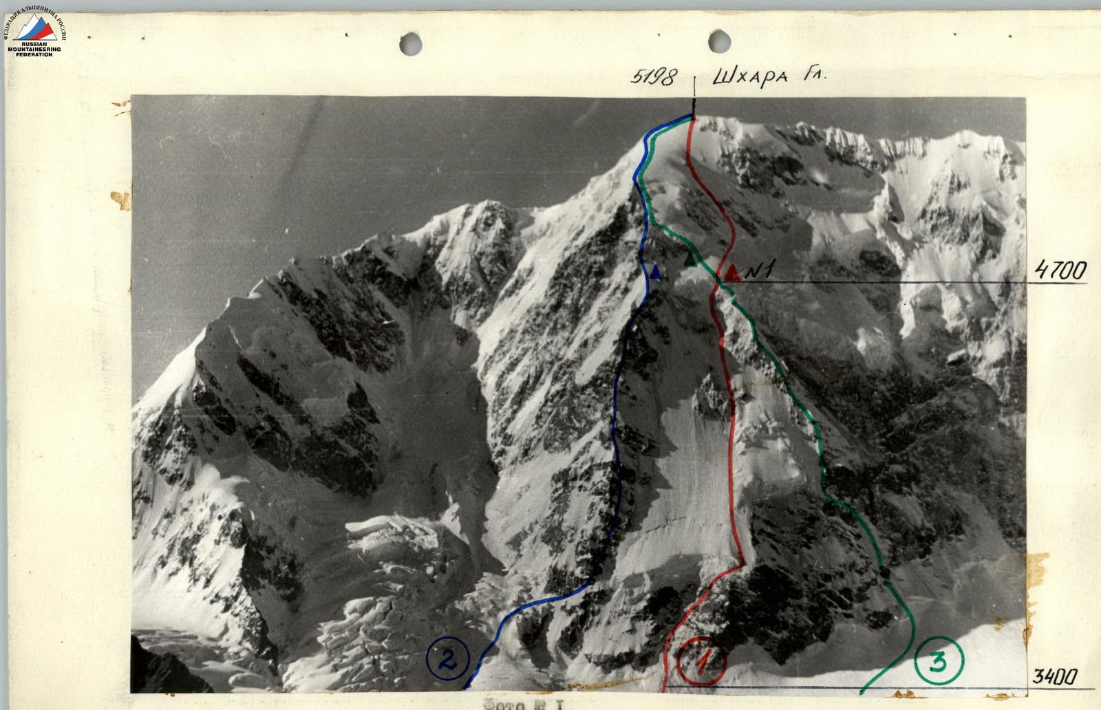
Photo №11. General photo of the summit. Taken from Semenovsky pass, 1984, Helios 81, focal length 53, distance 2 km, HN1, 4010 m. 1. Route climbed by the team. 2. Tomachek's route, 5B category difficulty. 3. Krainov's route, 5B category difficulty.