Ascent Logbook
- Type of ascent: ice and snow climb.
- Ascent area: Central Caucasus, Bezengi.
- Peak Shota Rustaveli, 4960 m, via the north face.
- Estimated difficulty category: 5B.
- Route characteristics: Total height difference of the route 1340 m, height difference of the wall section 1180 m, average steepness of the wall section 48°, route length 2400 m, wall section length 1660 m, length of sections with 5–6 difficulty category 1355 m.
- Pitons used: Ice pitons for belay 257, ITO 6, rock pitons for belay 12.
- Total climbing hours: 24.
- Two bivouacs (one on descent), both comfortable.
- Team members: Laletin A.V., CMS — team captain Razumov Yu.M., MS — team coach Shustrov N.B., CMS — deputy team captain Zhukov S.Ya., CMS Shustrov A.B., CMS Gurevich V.B., CMS Neplokhov A.D., CMS Stroganov Yu.V., CMS.
- Team coach: Razumov Yu.M., MS.
- Date of departure on the route July 15, 1983, date of return from the route July 17, 1983
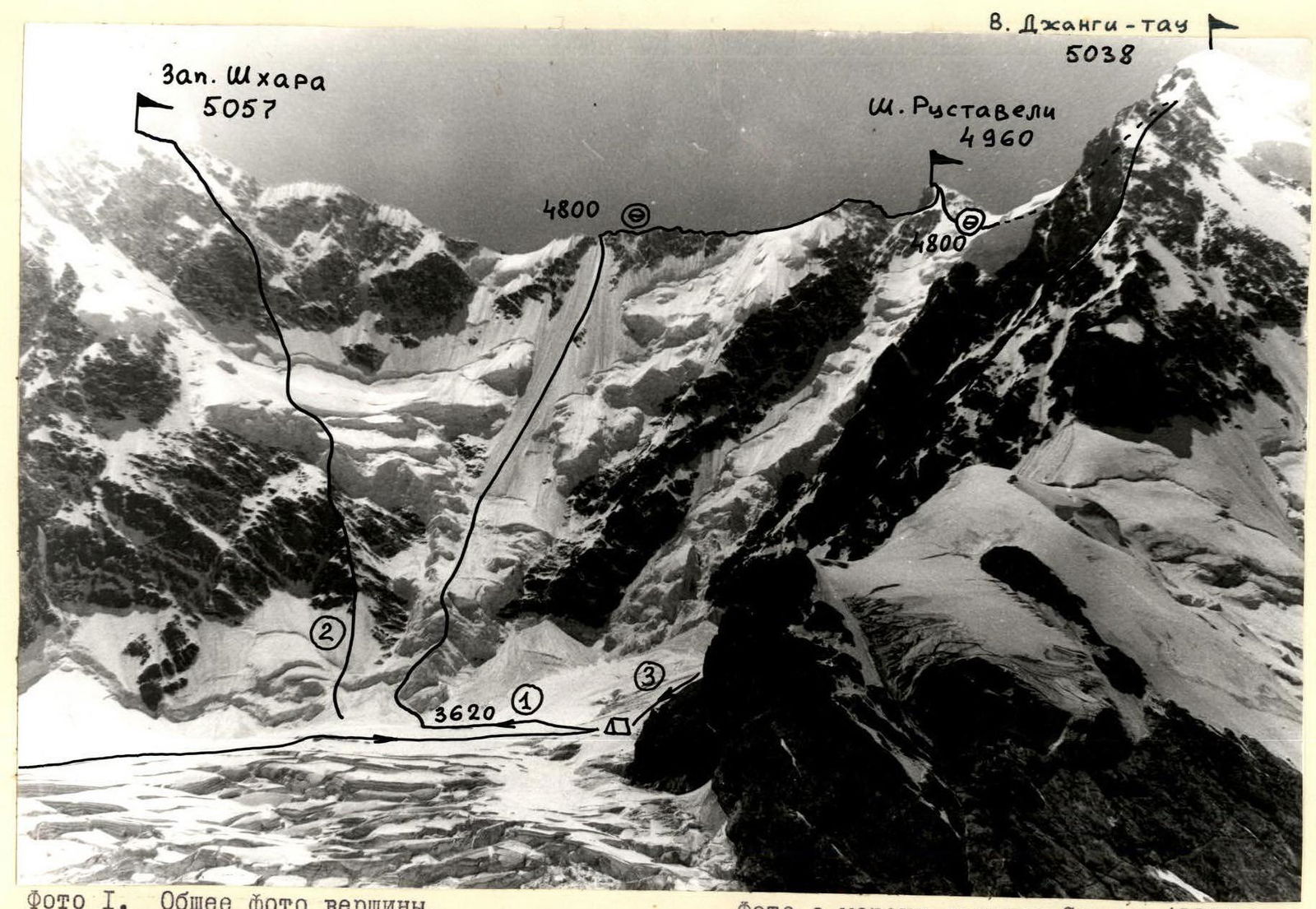
Photo 1. General photo of the summit. 1 — team route 2 — Blankovsky's route, 1980, 5B category 3 — 4B category route to East Dzhangi-tau
Photo taken from the moraine of Sella glacier (3300 m) on July 18, 1983, 11:00, lens I-50, distance 4 km, point #1.
| Ice Pitons | Rock | Diagram | Description of the section (difficulty category, avg. steepness, length, R-number) |
|---|---|---|---|
| 4 | - | ||
| July 16, 4800 m, 80°, 7 m R12 | |||
| 50°, 200 m R11 | |||
| 5 | 7 | 10°, 180 m R10 | |
| 3 | - | 0°, 160 m R9 | |
| 16 | 5 | 0°, 260 m R8 | |
| 5T | - | ||
| 80°, 12 m R7 | |||
| 32 | - | 60°, 135 m R6 | |
| 38 | - | 55°, 170 m R5 | |
| 118 | - | 50°, 550 m R4 | |
| - | - | 30°, 340 m R3 | |
| 12 | - | 50°, 180 m R2 | |
| 94 | - | 80°, 45 m R1 | |
| 15 | - | July 14, 3620 m, 45°, 180 m R0 | |
| 4/I | - |  | |
| 5 | 7 | ||
| 3 | - | ||
| 16 | 5 | ||
| 5/1 | - |  | |
| 32 | - | ||
| 38 | - | ||
| II8 | - | ||
| - | - | ||
| 12 | - | ||
| 9 4 | - |
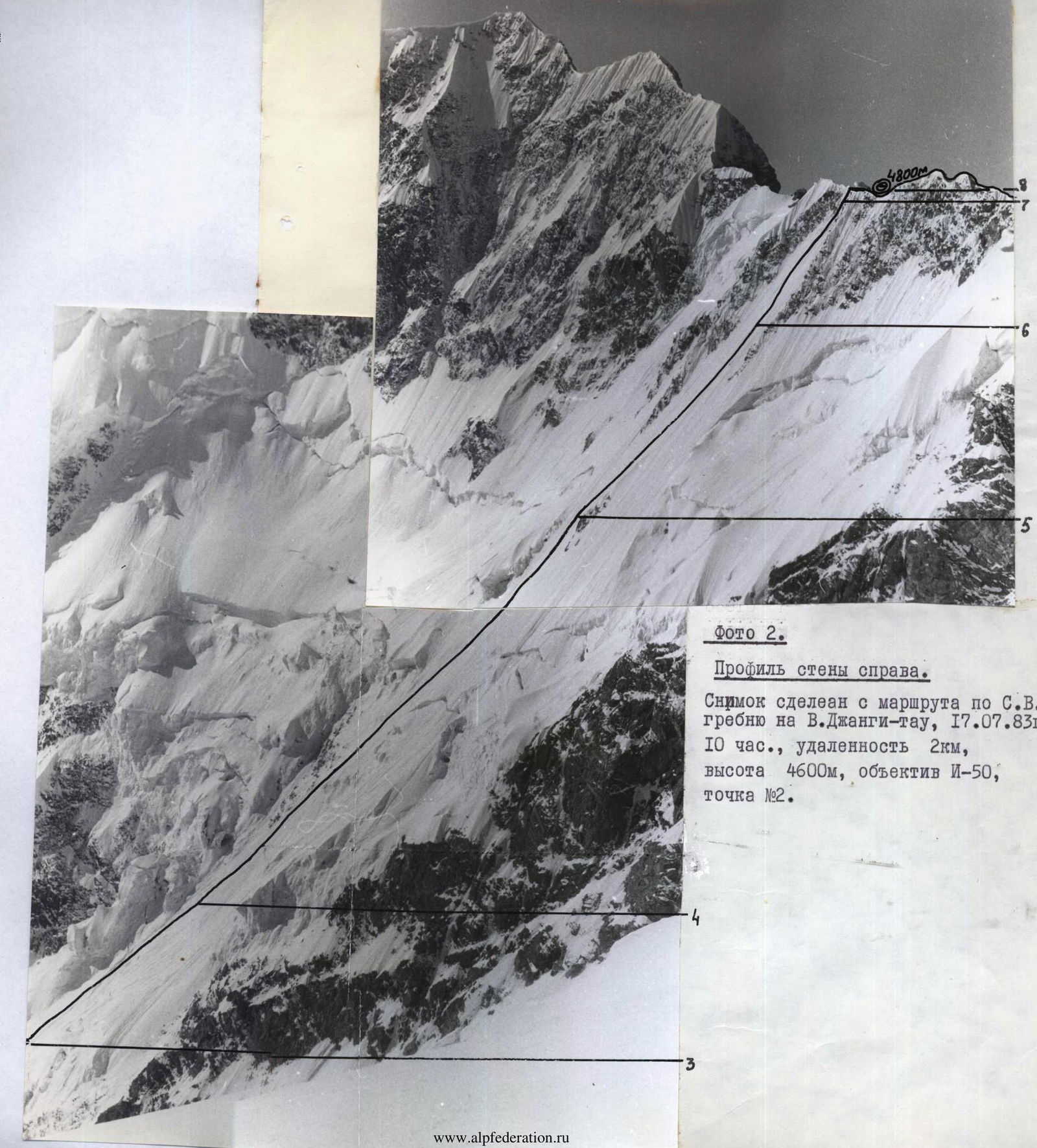
Photo 2. Profile of the wall on the right. Taken from the route along the NE ridge to East Dzhangi-tau, July 17, 1983, 10:00, distance 2 km, height 4600 m, lens I-50, point #2.
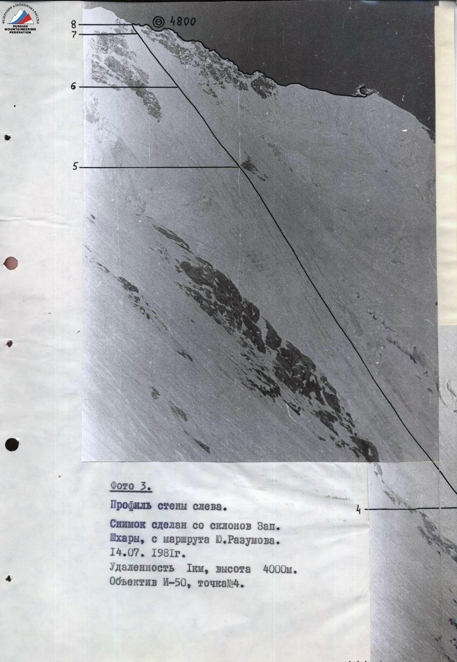
Photo 3. Profile of the wall on the left. Taken from the slopes of West Shkhara, from Yu. Razumov's route. July 14, 1981. Distance 1 km, height 4000 m. Lens I-50, point #4.
The route to Peak Shota Rustaveli via the north face was completed by the LGS DSO "Spartak" team as part of the Leningrad City Championship (ice and snow climbing category) with a full registered team of 8 people.
July 13, 1983 — departure from the "Bezengi" tourist camp, approach to the Dzhangi-kosh hut, viewing the route through binoculars.
July 14, 1983 — departure from the bivouac at 08:00, approaching the route at 09:30 in the upper cirque of the Bezengi glacier. Throughout the day, observing the route, taking photos in different lighting conditions, clarifying the paths and schedule of avalanches and icefall collapses. The Laletin-Razumov pair trod a path through the closed glacier to the start of the route and carefully examined the possible path to overcome the lower icefall of the route.
During the ascent, the team managed to implement a tactical plan option that provided for traversing the wall in one day.
July 15, 1983 — departure from the initial bivouac at 01:00, starting work on the route at 01:50, by 05:00 they had traversed the icefall (section R0–R3) and by 06:00 were at the start of the ice board, around 12:00 they passed the rock island, 17:00 — exit to the main ridge, at 18:00 they set up a bivouac.
July 16, 1983 — departure from the bivouac at 09:00, traversing the ridge towards Peak Shota Rustaveli; 17:00 — reaching the summit; 18:00 — bivouac on the plateau between Peak Shota Rustaveli and East Dzhangi-tau summit.
July 17, 1983 — departure at 08:00, descent along the NE ridge of East Dzhangi-tau summit.
July 18, 1983 — return to the "Bezengi" tourist camp.
The tactical movement scheme of the team flexibly adapted to the changing terrain. The lower part of the icefall (section R0–R1) was traversed by independent pairs, the same scheme was used on sections R2–R4 and on the ridge (section R8–R13).
The pairs were: Laletin A. – Shustrov A., Neplokhov A. – Gurevich V., Razumov Yu. – Zhukov S., Shustrov N. – Stroganov Yu. On sections R1–R2, R7–R8, and R12–R13, interaction between pairs was organized. The most tactically interesting section is the ice board (section R4–R8). Here, to speed up the group's movement and compact its arrangement, movement was carried out by two independent foursomes moving in parallel. The first two pairs and the last two pairs merged. Within the foursomes, pairs moved with constant interaction, the first in each foursome had lighter backpacks. Leaders were rotated every 5–6 ropes, so all team members worked as leaders. Modern ice climbing equipment was widely used: crampons on a rigid platform, ice axes, and "ice fidis". Belaying was done through ice pitons. This tactical scheme allowed the team of 8 people to overcome the ice board with a height difference of about 700 m in 11 climbing hours.
Both bivouacs on the route were set up on the ridge. The first platform was carved into the ice, lying down, with two tents set up. No water. The second — in similar conditions, but dug into the snow. Bivouacs were comfortable.
Throughout the ascent, the group maintained stable radio communication with the Dzhangi-kosh hut according to the schedule provided by the tactical plan. "Lastochka" radios were used.
There were no falls or injuries during the ascent.
Route Description by Sections
Sections R0–R4. Icefall, representing a system of ice walls separated by more gentle sections, often covered with deep heavy snow carried by avalanches. Movement is mostly simultaneous by independent pairs, belaying through ice pitons. From the lower point of the icefall, move left along its wall to a large lower bergschrund crossing the wall and icefall. After the bergschrund — right-up towards the central part of the icefall and further along it. The biggest difficulty is presented by a large ice scoop (section R1–R2). From the central ridge of the icefall, leading under the scoop, move:
- Straight up through a small bergschrund, the upper wall of which overhangs (2.5 m).
- Further along the steep ice wall to a small pocket, where it is convenient to organize a belay point.
Above the pocket — an overhanging wall. It is passed in the right part, where its height decreases to 2 m. Movement is complicated by the fact that solid ice in this section often gives way to soft and even firn ice, making it difficult to organize belaying. The section requires alternating movement with interaction between pairs, belaying through ice pitons. On sections R0–R3, preliminary study is necessary, as they are traversed in the dark.
Sections R4–R8. Traversing the ice board begins with overcoming an overhanging two-meter wall of the bergschrund (point 4), further — towards the rock island (point 5), photograph #. Slightly below the rock island to the right of the ascent path, there are ice crevices where, if necessary, a safe bivouac can be organized. It should be used if the group is climbing in warm weather conditions, when movement along the ice board in the second half of the day is dangerous due to:
- snow avalanches falling from the upper part of the board,
- cornice falls from the ridge,
- rockfalls from the upper rock outcrops.
A bivouac near the rock island is less convenient and less safe. From the rock island — straight up towards the lowest point of the ridge. On sections R4–R8, movement is alternating, belaying through ice pitons. At belay points — 2–3 pitons, as the ice has a layered structure in places. In the upper part, the ice board becomes steeper, and the ice is significantly harder. Section R7–R8 is a steep ice pitch, ending with a snow cornice of the main ridge. A photograph is missing due to fog. The exit to the ridge is at the point where the cornice is minimal (about 1 m).
Sections R8–R11. Along the ridge left towards Peak Shota Rustaveli. Two ropes from the exit point to the ridge — an ice col, slightly below which a bivouac platform can be carved on the south side (photo #12). The ridge is heavily destroyed and snow-covered (photo #13), with an almost continuous cornice on the north side. Movement should be directly along the ridge, detours to the left are irrational. Ridge belaying, there are two rappels (photo #15).
Sections R11–R13. Ascent to the summit of Peak Shota Rustaveli along a snowy ridge turning into a steep snow-ice pitch to the right of the rock wall of the summit tower (photo #14). Backpacks can be left behind. Before the summit — an ice wall with a small cornice (photo #17). Belaying — ice pitons. The summit is to the left along the way at the exit of the rocks; there is no pronounced summit cairn.
Descent initially follows the ascent path for 3–4 ropes, then to the plateau between Peak Shota Rustaveli and East Dzhangi-tau summit. Comfortable bivouac. Further descent along the NE ridge of East Dzhangi-tau summit via the 4B category route.