
200 198
- Climbing category: technical
- Climbing area: Caucasus, Bezengi, Northern spur of MGHR. 2.3.
- Peak: Ural (Western) (4300 m).
- Proposed difficulty category: 5B. 45, pr. 507, p.4, 26/5–81.
- Route character: combined.
Height difference: 520 m. Average steepness: 63°. Length of sections: 4th cat. diff. — 155 m; 5th cat. diff. — 265 m; (of which 5B and 6 cat. diff. — 80 m)
- Driven pitons:
| for belay | for creating ITO |
|---|---|
| rock 32 | — |
| ice (ice screws) 20 | — |
| chocks 1 | — |
-
Number of walking hours – 18
-
Number of overnight stays –
-
Participants:
- Ryabukhin A.G. — Master of Sports
- Lushnikov A.N.
- Tyrtyshny S.A.
- Ulyanov A.R. — 1st sports category
-
Team coach: Ryabukhin Alexander Grigorievich — Honored Coach of the RSFSR, Master of Sports of the USSR.
-
Date of starting route preparation: August 10, 1980.
-
Date of starting the route and returning: August 11, 1980.
Scheme of the climbing area.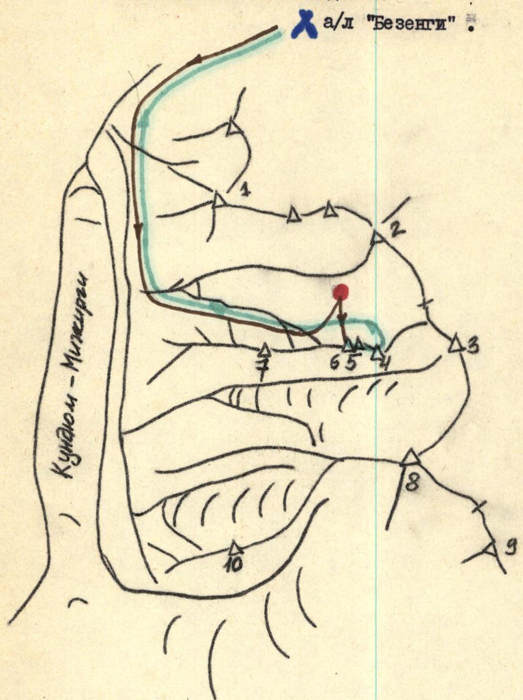
- To the memory of friends.
- Ukyu.
- Dumala.
- Ural (Maly).
- Ural (Eastern).
- Ural (Western).
- Archimedes
- Ullu-Auz-Bashi.
- Skalny.
- Panoramnыy.
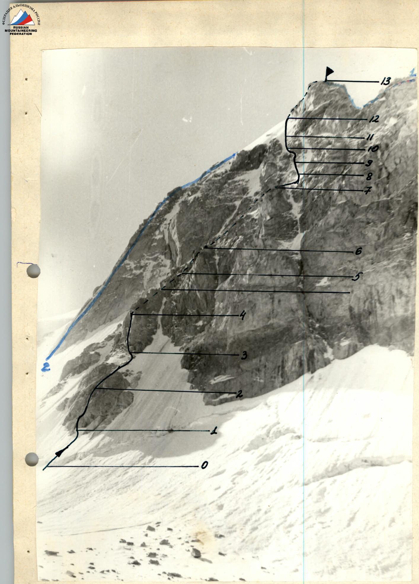
Route profile.
- Traverse W.–E. peaks 5A cat. diff.
- Ural (Eastern) along the counterfort of the N. wall 5B cat. diff.
Sections R0–R8. "Crab". The first ascent to the Western and Eastern peaks and the traverse of the Ural massif was made from July 14 to 18, 1961, by a group consisting of:
-
- Ryazanov V.I. — Master of Sports — leader
-
- Ryabukhin A.G. — 1st sports category
-
- Samokhvalov V.V. — 1st sports category
-
- Benkin V. — 1st sports category
-
- Chernov V.I. — 1st sports category
Currently, the following routes are laid to the peak Ural:
- Traverse W.–E. — 5A cat. diff.
- Eastern along the counterfort of the N. wall — 5B cat. diff.
- Eastern or Western along the N. wall — 4A cat. diff.
- Maly Ural along the E. ridge — 3B cat. diff.
The first ascent to v. Ural (Western) along the counterfort of the N. wall was made by a group from the "Bezengi" alpine camp consisting of:
-
- Ryabukhin A.G. — Master of Sports — leader
-
- Tyrtyshny S.A. — 1st sports category
-
- Lushnikov A.N. — 1st sports category
-
- Ulyanov A.R. — 1st sports category
from August 10, 1980, to August 11, 1980. The approach from the "Bezengi" alpine camp takes 4 hours to the Green overnight stays under the Maly Ukyu glacier and another 1.5 hours to the overnight stays on the moraine of the Maly Ukyu glacier under the peak Ukyu.
August 10, 1980.
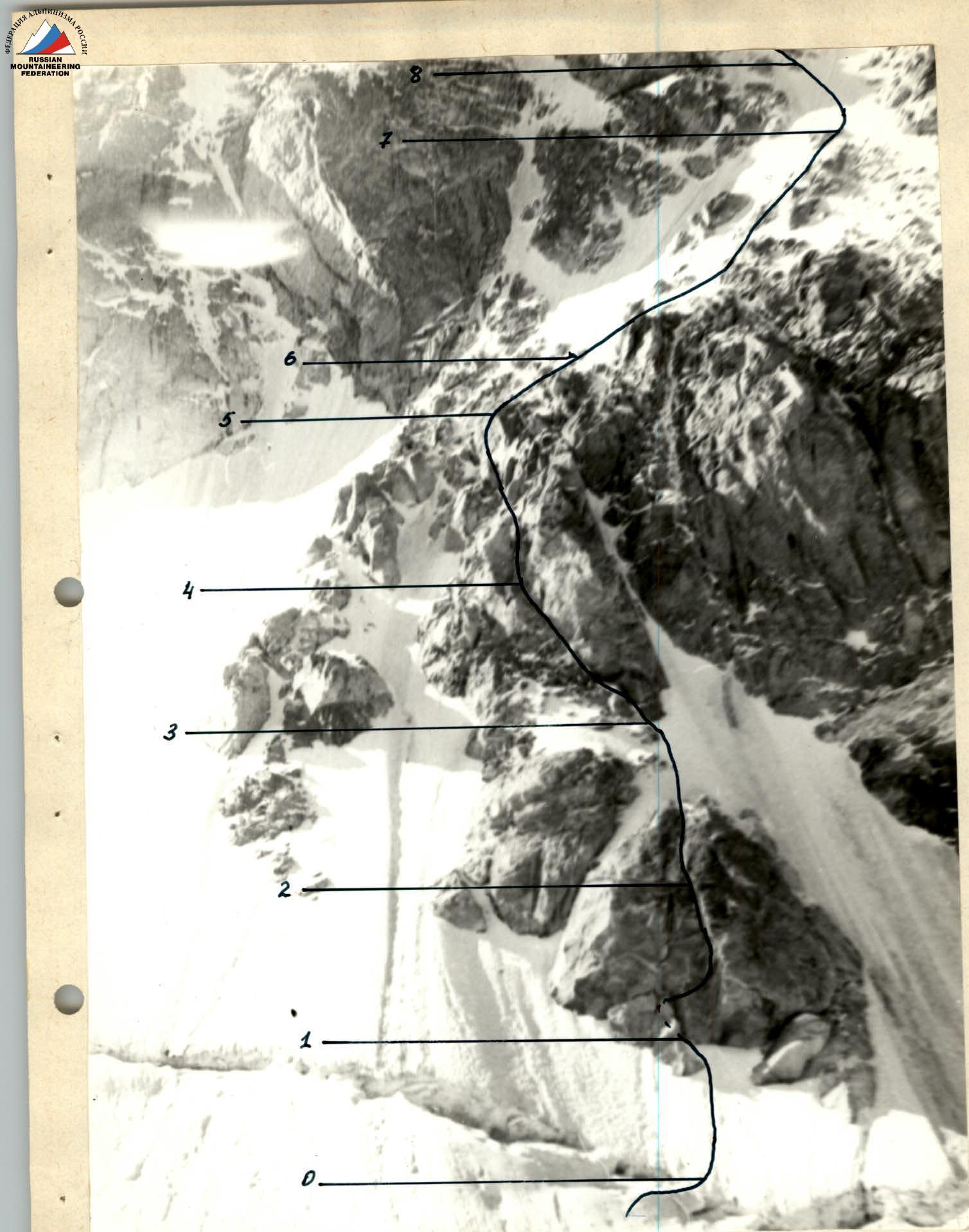
The group went to overnight stays under v. Ukyu and from 8:00 conducted observations of the route. The route itself is not prone to rockfall, as it is under the cover of the counterfort rocks. The bypasses at the start of the route ("crab" and "pyramid") along the couloirs on the left and right are hazardous: traces of stones are visible along the couloirs and stones are seen beyond the bergschrund.
In the second half of the day, the pair Tyrtyshny — Lushnikov went to process the route (sections R0–R3).
Section R0–R1.
Through a snow bridge over the bergschrund into the left claw of the "crab"; 30 m of snow with a steepness of 40–45°.
Section R1–R2.
Left up into a wide crack, and then right along a slab (6 m), difficult rocks. Further up the left crack of the chimney under a cornice (4 m), difficult rocks, partially covered with moss. Cornice (1.5 m) with a wide crack, we hang a ladder on a chock and exit onto a slab – 80°. Along the slab (4 m) onto complex, fragmented rocks covered with moss. We move along the right crack, narrowing towards the top of the chimney (10 m), partially overhanging. (1st control point, a can hung on a piton). Further 10 m along destroyed, snow-covered rocks. We organize a reception point. (6 rock pitons + 1 chock).
Section R2–R3.
Along snow-covered rocks (15 m) exit to the upper part of the "crab" and up the snow – 30–35° with an ice sublayer under the base of the rusty pyramid (25 m). (2 rock pitons).
Processing took 3 hours.
August 11, 1980.
Departure from overnight stays at 5:20. From overnight stays to the start of the route 10 min. At 6:00 the group passed the processed sections and continued moving along the route.
Section R3–R4.
Under the rusty pyramid left along the snow onto a snow-covered ledge and further along snow-covered rocks of medium difficulty (35 m). (4 rock pitons).
Section R4–R5.
Along complex rocks, partially snow-covered, exit to the top of the pyramid (40 m) — 2nd control point. A good platform for overnight stay. Bypassing the pyramid along the rocks is safe, as it is under the cover of the pyramid itself, and then under the cover of a rectangular rock.
Section R5–R6.
Up along the left side of a vaguely expressed counterfort. Having passed 40 m of fragmented rocks of medium difficulty, partially with verglas, snow, we exit under the base of a snow-ice gully going left up. (3 rock pitons + 1 ice piton).
Section R6–R7.
Crossing a steep ice gully (15 m), "Caution! Rocks may fall from above!", we move right onto difficult rocks (partially with verglas, snow) and along them 25 m we move towards a characteristic lowering in the NW ridge. We exit onto the top of a triangle formed by rock islands in 40 m. (4 rock pitons + 1 ice piton). Here the entire group puts on crampons and does not remove them until exiting onto the saddle between the peaks (Eastern) and (Western) Ural.
Section R7–R8.
9:00. From the top of the triangle formed by rock islands, up and left we cross a steep ice couloir separating the counterforts (20 m). "Caution! Rocks may fall from above!".
We have to move on front points with the use of an ice axe. We exit onto rock islands, in the direction of the eastern extremity of v. Ural (Western) 25 m. Rocks are destroyed, of medium difficulty. (2 rock pitons + 2 ice pitons).
Section R8–R9.
9:35. The start is along rocks of medium difficulty 20 m, then up a steep ice-snow couloir in the direction of a lowering in the ridge. 25 m. The first one moves on front points with an ice axe. (3 ice pitons).
Section R9–R10.
From here we pass 40 m up along a complex ice gully with a steepness of 60° between rock islands. We exit right out of the gully 2–3 m closer to the plug along ice-covered, steep, complex rocks. The bypass on the left is very bad along smooth, overhanging rocks. (1 rock piton + 4 ice pitons).
Section R10–R11.
Further 40 m along the continuation of the ice gully. Steepness 60°, climbing is complex. (4 rock pitons + 4 ice pitons).
Section R11–R12.
12:30. Along a steep ice slope – 55° between rock islands we exit onto the saddle between the peaks (Western) and (Eastern) Ural 80 m. (The route leads directly under the summit tower). (1 rock piton + 4 ice pitons). Here in the hollow a good overnight stay is possible.
Section R12–R13.
Along rocks of medium difficulty 6 m and further simple terrain to v. Ural (Western) 40 m.
Time 13:50.
The descent from the summit Ural (Western) coincides with the route 5A cat. diff. — traverse of the Ural massif (through the Eastern peak). The group recommends descending from the summit (coinciding with the start of the W.–E. traverse) onto the saddle between the peaks Ural (Western) and Archimedes.
| Date | Section | Length | Avg. Steepness | Terrain character | Category of difficulty | Pitons driven | Pitons driven | Pitons driven | Weather conditions |
|---|---|---|---|---|---|---|---|---|---|
| rock | ice | chocks | |||||||
| 10.08.1980 | R0–R1 | 30 | 40–45° | snow slope | 2 | — | — | — | good |
| R1–R2 | 6 | 80° | rocks | 3 | 1 | 2 | 2 | —"— | |
| 4 | 70° | —"— | 3 | 1 | 2 | 2 | —"— | ||
| 1.5 | cornice | —"— | 6 | 2 | — | 1 | —"— | ||
| 4 | 80–90° | rocks covered with moss | 6 | 1 | — | — | —"— | ||
| 10 | 80–90° | fragmented rocks | 6 | 2 | — | — | —"— | ||
| 10 | 60–70° | snow-covered rocks | 4–5 | 1 | — | — | —"— | ||
| R2–R3 | 15 | 40–45° | —"— | 4 | 1 | — | — | —"— | |
| 25 | 30–35° | snow with ice sublayer | 3 | 1 | — | — | —"— | ||
| 11.08.1980 | R3–R4 | 35 | 30–35° | snow, snow-covered rocks | 3–4 | 4 | 1 | — | —"— |
| R4–R5 | 40 | 50–60° | rocks | 4–5 | 4 | — | — | —"— | |
| R5–R6 | 40 | 40–50° | fragmented, snow-covered rocks, verglas | 4 | 3 | 1 | — | —"— | |
| R6–R7 | 60 | 50° | ice | 4 | 4 | 1 | — | —"— | |
| R7–R8 | 20 | 40–60° | rock islands | 4–5 | 2 | 2 | 1 | weather deteriorating | |
| R8–R9 | 20 | 40° | rocks | 3–4 | 2 | — | — | —"— | |
| 25 | 40–60° | ice | 4–5 | — | 2 | — | —"— | ||
| R9–R10 | 40 | 60–65° | ice | 4–5 | 1 | 4 | — | fog | |
| R10–R11 | 40 | 60–65° | ice | 5 | 4 | 4 | — | snow | |
| R11–R12 | 80 | 55° | ice, rock islands | 4–5 | 1 | 4 | — | —"— | |
| R12–R13 | 6 | 60° | rocks | 4 | — | — | — | —"— | |
| 40 | 30–40° | —"— | 2 | — | — | — | —"— |
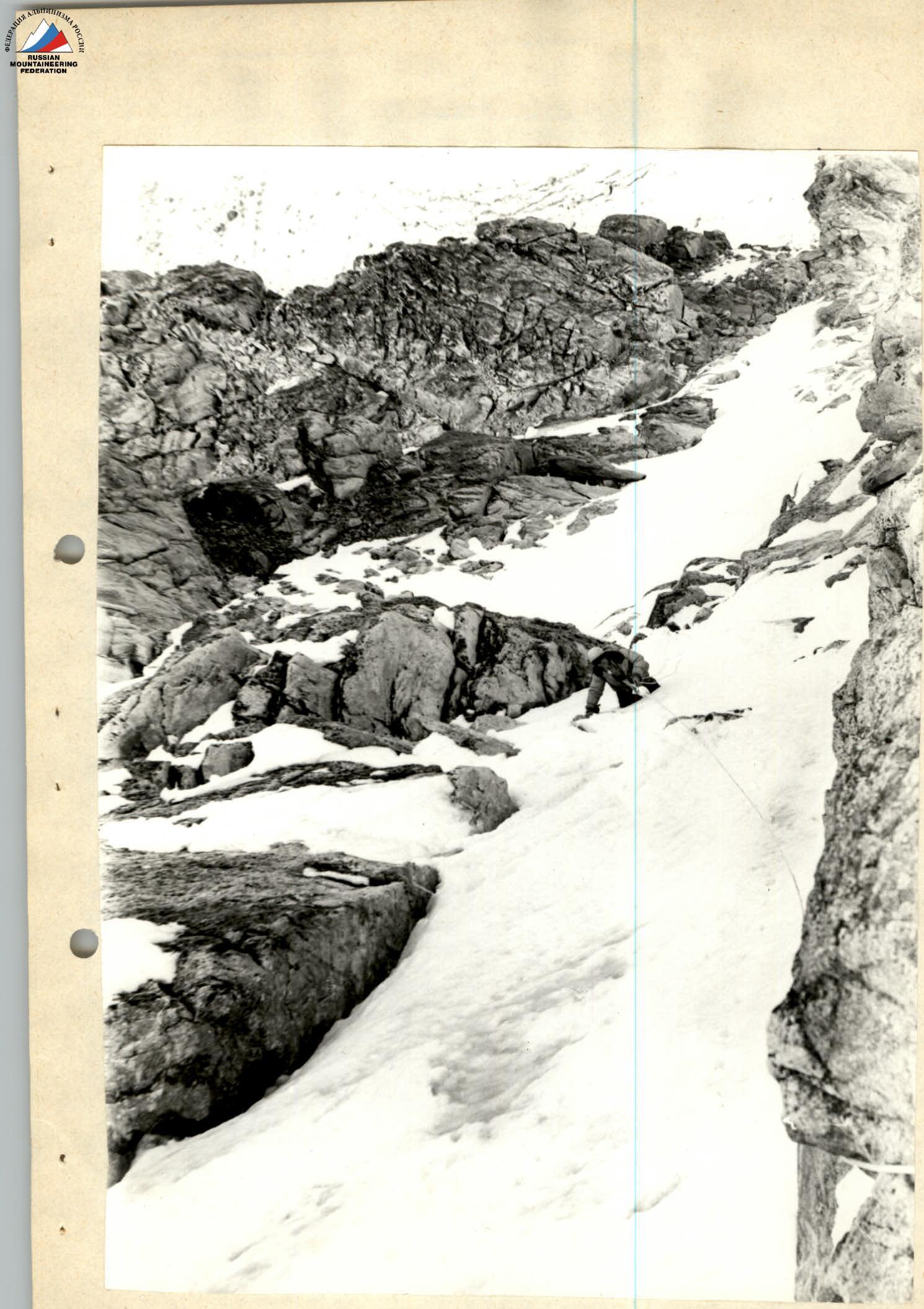
In the ice gully.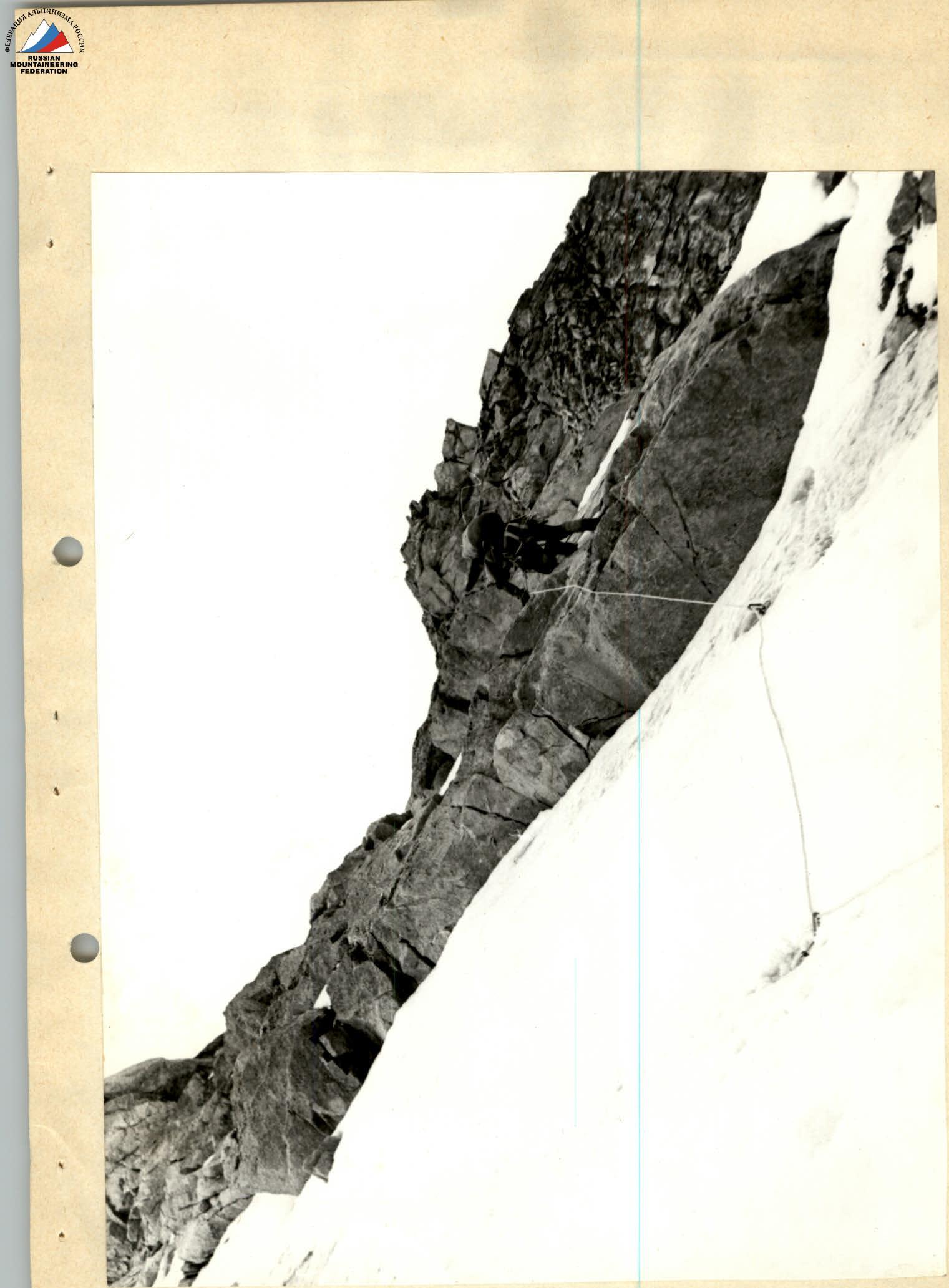
Exit to rock islands.
Comments
Sign in to leave a comment