Ascent Record
ascent of Maly Salynan peak via the North wall
- Ascent type — snow-ice
- Ascent area — Bezengi region, Kargashilsky ridge.
- Peak — Maly Salynan (4050 m)
- Route — via the North wall
- Estimated difficulty category — 4A
- Elevation gain — 400 m, distance — 520 m, average slope — 5°
- Pitons used (ice) — 60 (0)
- Duration — 11 hours
- Number of overnight stays — day trip
- Team leader — Isupov S.M. 1st category Team members: — Gavrilovich N.N. CMS Litinsky I.A. 1st category Rudchenko D.A. 2nd category
- Team coach — Belousov E.B. CMS
- Date of ascent — August 3, 1986 return — August 3, 1986
- Ascent organized by the alpine base "Bezengi" and Bezengi region tourist club.
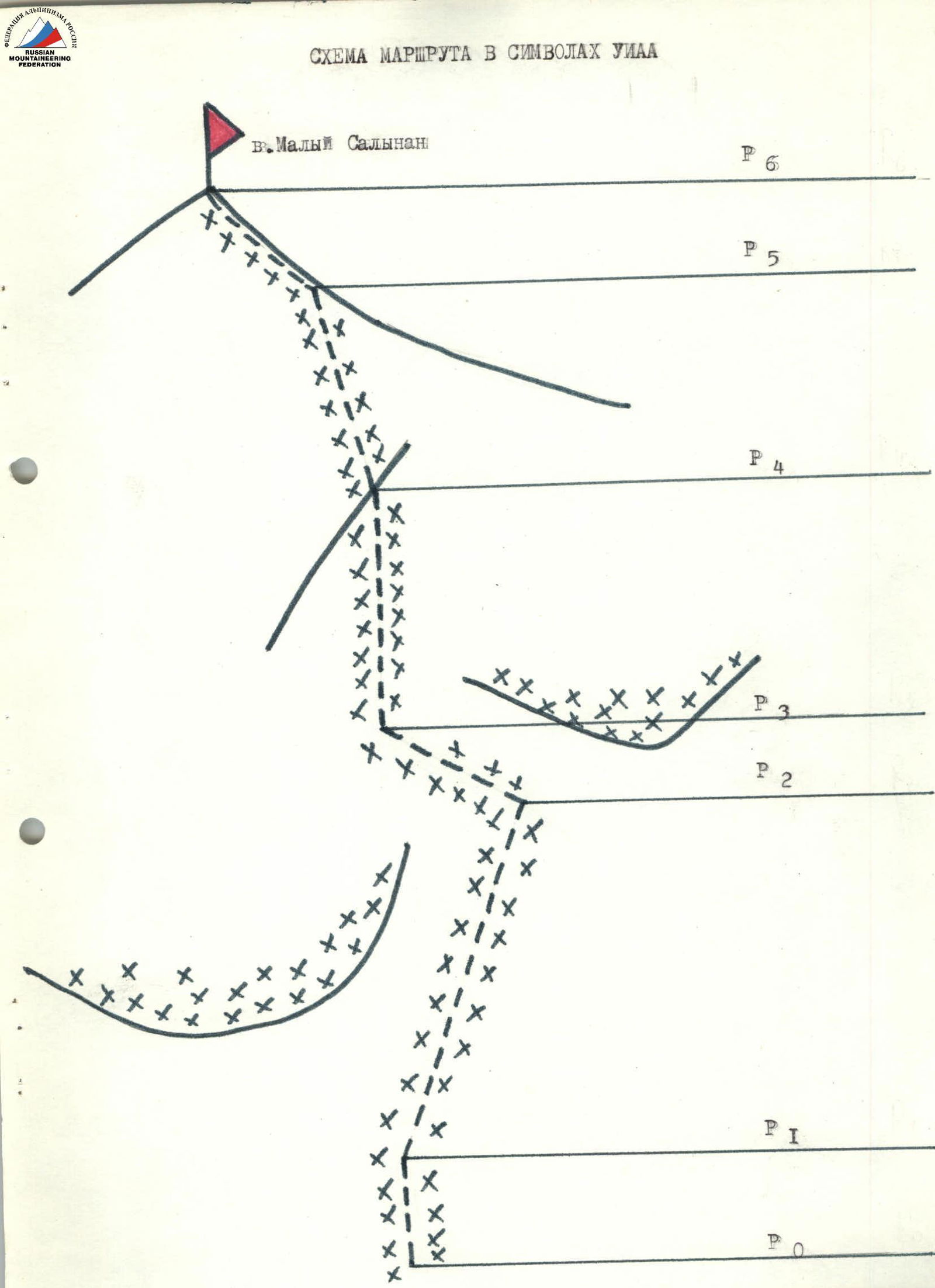
Route description for Maly Salynan peak
via the North wall (approximately 4A category)
From the overnight campsite on the right moraine of the Salynan glacier, ascend along the slopes of Shaurtu peak, bypassing the icefall, to the glacier plateau. Cross the plateau across the open part of the glacier and approach the northern slope of Maly Salynan peak. Move along the slope, bypassing the icefall from the hanging glacier on the slope of Maly Salynan peak. The start of the route is immediately after the icefall. 1.5–2.0 hours from the campsite.
From the plateau, ascend directly up the snowy slope to the bergschrund. From the bergschrund, move straight up the ice wall, bypassing the hanging glacier on the left and rock outcrops on the right, and approach the ice overhang (5 ropes). Slope steepness is 55°–60°. Move on the front points of crampons. Protection with ice screws. Then move up and to the left, bypassing the overhang (1 rope). Slope steepness at the end of the bypass is 70°. Continue straight up towards the upper part of the rocky outcrop, ending with an icy ridge (2 ropes). Slope steepness is 55°–60°. Upon reaching the rocks at the top of the outcrop, there is 5–8 m of ice. From the rocky outcrop, ascend the ice wall, slightly traversing left towards the pre-summit ridge (2 ropes). The peak rocks are visible on the left. Slope steepness is 50°. Reach the pre-summit ridge. Continue to the summit along the sharp icy ridge covered with snow (20 m). Protection with ice screws.
From the bergschrund to the summit — 6 hours. Descent from the summit along the East ridge, approximately via the 2B category route. 3 hours to the campsite.