Route Description
First ascent to p. Pushkin (5100 m) on the southern wall (approximately 56 k.tr.)
Group a/l "Bezengi" under the leadership of Gorevsky N.N.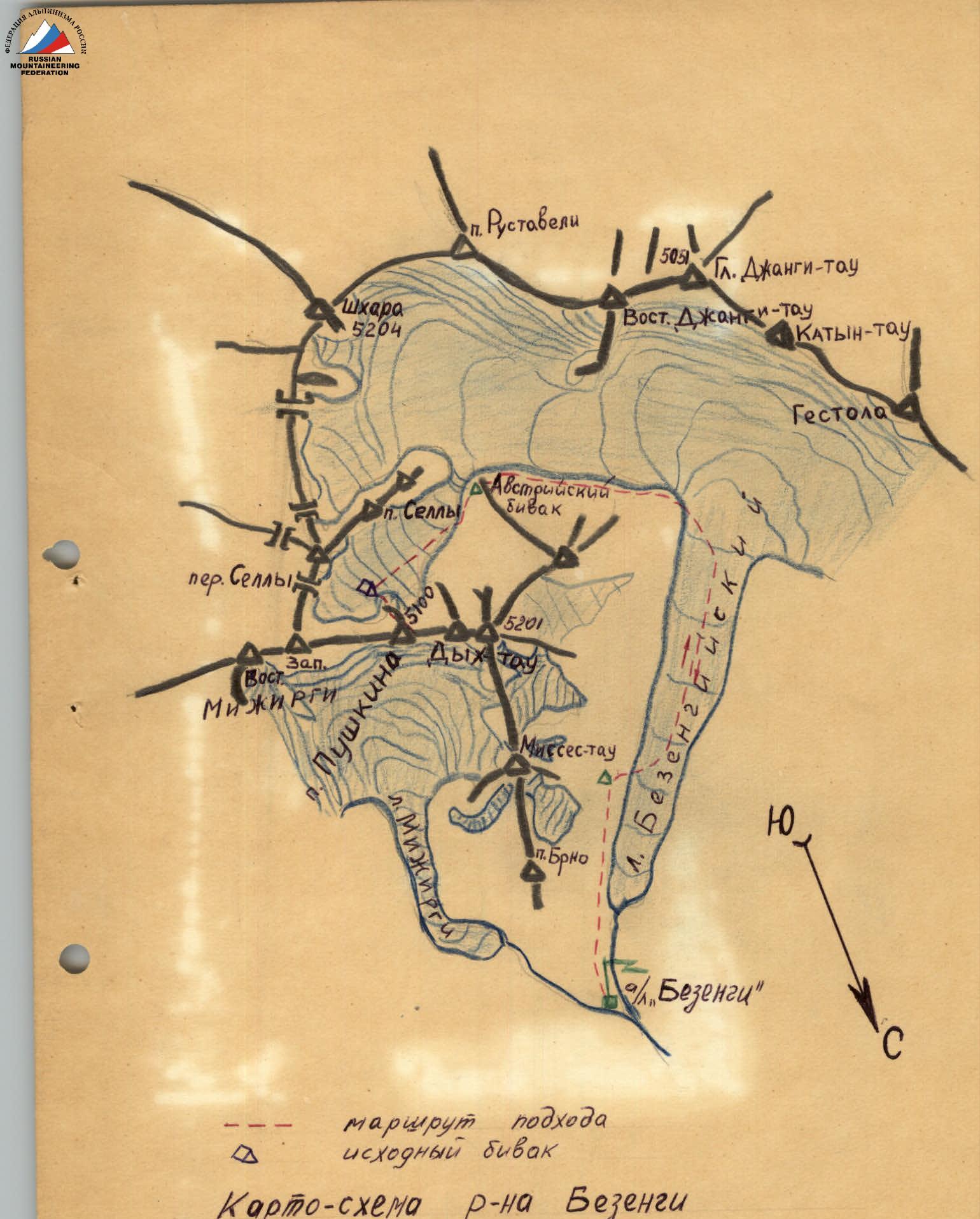
Route Description
From the camp along the trail or through the middle of the Bezengi glacier to the so-called "Austrian camps", then through the "sickle-shaped moraine" by the usual path leading to the Sella pass, to the plateau under Pushkin Peak. From the camp 8–9 hours.
The wall of Pushkin Peak, in its lower part, is a triangle dissected by a narrow vertical couloir. The height of the lower part of the wall is about 700 m.
The route passes along the right side of the wall. The beginning of the route goes along a snowy slope, to the right of the avalanche chute, through the bergschrund, and then along rocks of the "sheep's forehead" type to the base of an inclined shelf leading upwards to the right. Further along the shelf to its end (8 ropes).
The shelf ends with a snowy slope going into the couloir. Without entering the couloir:
- straight up the icy rocks (2 ropes);
- exit to a horizontal shelf.
The shelf is wide, there is a place for an overnight stay at the end of the shelf. Above is a belt of overhanging rocks, possibly falling stones and ice. Stay closer to the wall. From the overnight stay on the plateau 6 hours.
Traversing along the shelf to the left, exit to the right bank of the couloir separating the wall of p. Pushkin.
Without entering the couloir, along the inner corner with an overhanging balcony - exit to complex monolithic rocks, which lead to the upper part of the belt of overhanging rocks.
This section of the route is overcome with the use of artificial support points, it is recommended to pull up backpacks. Difficult climbing. 1 rope - 2 hours.
Further move along large-block rocks to the right upwards to the snowy couloir (4 ropes). Having crossed the couloir to the right (along the way) bank, continue the ascent along snow-covered rocks of the "sheep's forehead" type to a steep rock rise. Approximately 2 ropes.
Without going out onto the rocks, the couloir must be crossed and climb along the left bank. The left bank of the couloir is a sheer wall with traces of falling stones. The steepness of the couloir increases from 50 to 65–70°.
In the upper part, the couloir is crossed again and exit to the ridge.
- The length of the couloir is 4 ropes.
- On the ridge there are convenient overnight stays.
- From the horizontal shelf 6–7 hours.
The ridge is rocky, steep, and heavily destroyed. Further movement is to the right of the ridge along a snowy slope with outcrops of icy rocks. Further, about 100 m along destroyed rocks of medium difficulty (several walls 3–5 m with difficult climbing) upwards - to the right, bypassing the overhanging blocks of the ridge to the base of a sheer rocky couloir. The length of the couloir is about 40 m. Along the couloir straight up - difficult climbing, use of artificial support points, pulling up backpacks.
Exit to a snowy rocky ridge. Along the ridge to a steep rocky ascent.
The ascent is bypassed to the right along an inclined shelf and then along rocks upwards (about 100 m). The shelf and all rocks up to the summit are heavily snow-covered. Under the snow, there is ice in places. Rocks of medium difficulty and difficult.
Further to the left, exit to a snowy ridge, resting against a rocky massif. Movement to the right of the rocks, along the edge of the ice. There are few footholds. Under the snow - ice.
Insurance through rock hooks. Climbing is of medium difficulty, the last 1.5–2 ropes - difficult.
Exit to the Mizhirgi - Dykh-Tau ridge 100 m west of Pushkin Peak under an overhanging rock. Platform for overnight stay. From the overnight stay along the snowy ridge with large cornices to the north - exit to the summit of Pushkin Peak.
For descent, two options are possible, approximately equal in time and complexity:
- Traverse to the saddle between the East and Main peaks of Dikh-Tau from the north and further along the Dikh-Tau couloir to the south.
- Along the ascent route.
| Section # | Steepness, ° | Length | Characteristics by Relief and Difficulty | Insurance Method | Time Taken. Number of Driven Hooks |
|---|---|---|---|---|---|
| R0–R1 | 45° | 150 m | Snowy slope with outcrops of rocks of the "sheep's forehead" type, in the lower part of the slope is a bergschrund. Rocks of medium difficulty. | Ice axe, rock hooks | 1 hour, 5 rock hooks |
| R1–R2 | 50° | 320 m | Inclined shelf crossing the wall at an angle of 45°. The shelf is scree, at the time of passage, there is snow in places. Icy rocks of the "sheep's forehead" type. | Rock hooks, rock outcrops | 4 hours, 8 rock hooks |
| R2–R3 | 60° | 60 m | Icy rocks of the "sheep's forehead" type. | Rock hooks | 1 hour, 3 rock hooks |
| R3–R4 | 15° | 150 m | Horizontal shelf, snow-covered. Above are overhanging rocks. | Rock hooks | 1 hour 30 minutes, 4 rock hooks |
| R4–R5 | Overhanging | 10 m | Overhanging rocks with a small number of footholds, passed with the use of artificial support points (ladders), backpacks were pulled up. | Rock hooks | 40 minutes, 5 rock hooks |
| R5–R6 | 80° | 30 m | Monolithic rocks with narrow cracks and a small number of footholds. Passed with the use of artificial support points (hooks). The first one passes without a backpack. Difficult climbing. | Rock hooks | 1 hour 30 minutes, 5 rock hooks |
| R6–R7 | 60° | 100 m | Large-block dissected rocks. Climbing of medium difficulty. | Rock hooks and outcrops | 1 hour 20 minutes, 2 rock hooks |
| R7–R8 | 40° | 100 m | Snowy slope with outcrops of rocks of the "sheep's forehead" type. | Rock outcrops | 1 hour |
| R8–R9 | 55° | 150 m | Narrow snow-ice couloir. Passed along the left (along the way) side, with an exit to the right in the upper part of the couloir. Steepness reaches 65°, icing of rocks, difficult climbing. | Rock hooks and outcrops | 2 hours, 5 rock hooks |
| R9–R10 | 45° | 120 m | Snowy slope to the right of the ridge with outcrops of destroyed rocks. Under the snow, there is ice in places. | Rock hooks and outcrops | 1 hour, 5 rock hooks |
| R10–R11 | 65° | 100 m | Destroyed rocks of medium difficulty, in places difficult (walls 3–4 m) | Rock hooks and outcrops | 2 hours, 5 rock hooks |
| R11–R12 | 85° | 35 m | Sheer narrow couloir with individual live rocks. Rocks are monolithic, weakly dissected. Passed with the use of ladders. Climbing is very difficult. Pulling up backpacks. | Rock hooks | 2 hours, 6 rock hooks |
| R12–R13 | 30° | 150 m | Snowy ridge with outcrops of rocks of the "sheep's forehead" type. | Ridge and rock outcrops | 1 hour 30 minutes |
| R13–R14 | 45° | 100 m | Bypass of the ridge ascent to the right along a rocky shelf with a small number of footholds and along snow-ice slopes. | Rock hooks | 1 hour 30 minutes, 5 rock hooks |
| R14–R15 | 30° | 100 m | Snowy ridge | Ice axe | 30 minutes |
| R15–R16 | 50° | 200 m | Snow-ice slope to the right of the rocky ridge leading to the sub-summit. In the upper part, the steepness reaches 60°. | Rock hooks | 5 hours, 9 rock hooks |
| R16–R17 | 20° | 100 m | Snowy ridge with cornices to the north. | Ice axe | 30 minutes |