
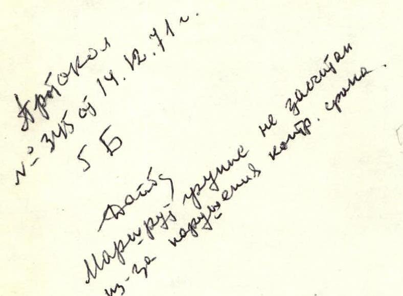
Protocol № 345 dated 14.12.1971
5B
The route was not credited to the group due to exceeding the time limit.
REPORT
ON THE FIRST ASCENT OF PIK PIONER VIA THE NORTH-WESTERN WALL (DUMALA VALLEY, CAUCASUS)
19–22 August 1971
 www.alpfederation.ru↗
Introduction
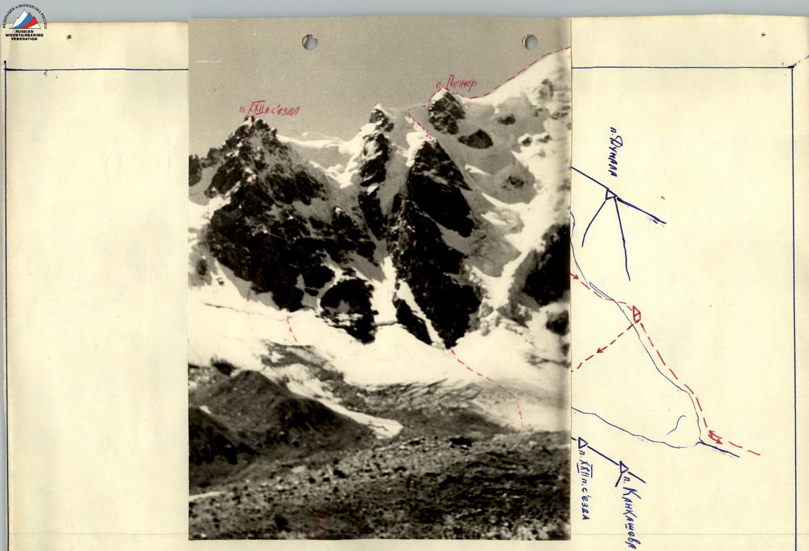
Pik Pioner, 4000 m, is located in the Koshtan-Krest ridge. Its eastern slopes are not high (350–400 m), and the approach to it is possible from the Cherek-Balqarskiy river valley. Towards the Dumala valley, which is often visited by climbers from the "Bezengi" alpine camp and various gatherings, lies a kilometer-long, mainly rocky wall that inevitably attracts the attention of climbers.
The exploration of the Koshtan-Krest ridge practically began in 1969 when the main group of the gathering of the Moscow Regional Council of the "Trud" Sports Society, led by A. Naumov, traversed part of the ridge, passing through Pik Pioner in the process. Following this, the second half of the ridge was also traversed. New routes were ascended from the valley:
- to Pik Koshtan-Tau (group of Monogarov and Naumov),
- to Pik Kankameve (group of Kudinova).
The last first ascent in the Koshtan-Krest ridge area was made in 1970 by a group from the "Bezengi" alpine camp led by Daruga on Pik XXII Congress of the CPSU via the north-western wall. That route, rated 5–6 category difficulty, was ascended on 27–28 July 1971 by our group as well. Even while approaching the route, and then during its ascent, the group members increasingly felt the desire to climb Pik Pioner via the almost sheer rocky wall. It was clear (from observations made from a distance of 500–600 m) that this wall, having roughly the same length, was significantly steeper and less dissected. Over two days of good weather, there were no observed rockfalls. The location for an intermediate bivouac in the middle of the wall was also identified. It seemed that the entire route could be ascended in two strenuous days.
At the end of the second shift at the "Bezengi" alpine camp, the group got the opportunity to make this first ascent. The group members included:
- the camp instructor, Master of Sports Benkin V. (leader),
- Bochkov V.,
- our fellow countrymen, first-class climbers Bebyakow A.,
- Ovsyannikov B.
All participants were in good physical condition, having completed 2–4 ascents of the fifth category of difficulty during the gatherings of the Kuibyshev Regional Council of the "Trud" and "Burvestnik" Sports Societies.
Route Description
18 August
At 7:00, the group departed from the "Bezengi" alpine camp by tractor and was delivered to the farm at the entrance to the Dumala valley by 8:30.
At 9:00, they began their ascent and followed a familiar trail, reaching the "Green Glade" below Pik Dumala by 16:00.
From the moraine of the glacier, the upcoming route was reviewed once more. It became clear that after traversing the rocky wall, an ascent up a steep icy slope to the main ridge would be necessary, and traversing under it to the rocky summit tower was not logical. At 18:00, radio contact with the camp was not established.
19 August
The group departed from their bivouac at 5:00. They crossed the glacier and ascended a snowy slope to reach the base of the rocky promontory by 6:00. To access the rocks, they crossed the crevasses of the glacier via a bridge. After successfully contacting the camp, they began their ascent up the rocks.
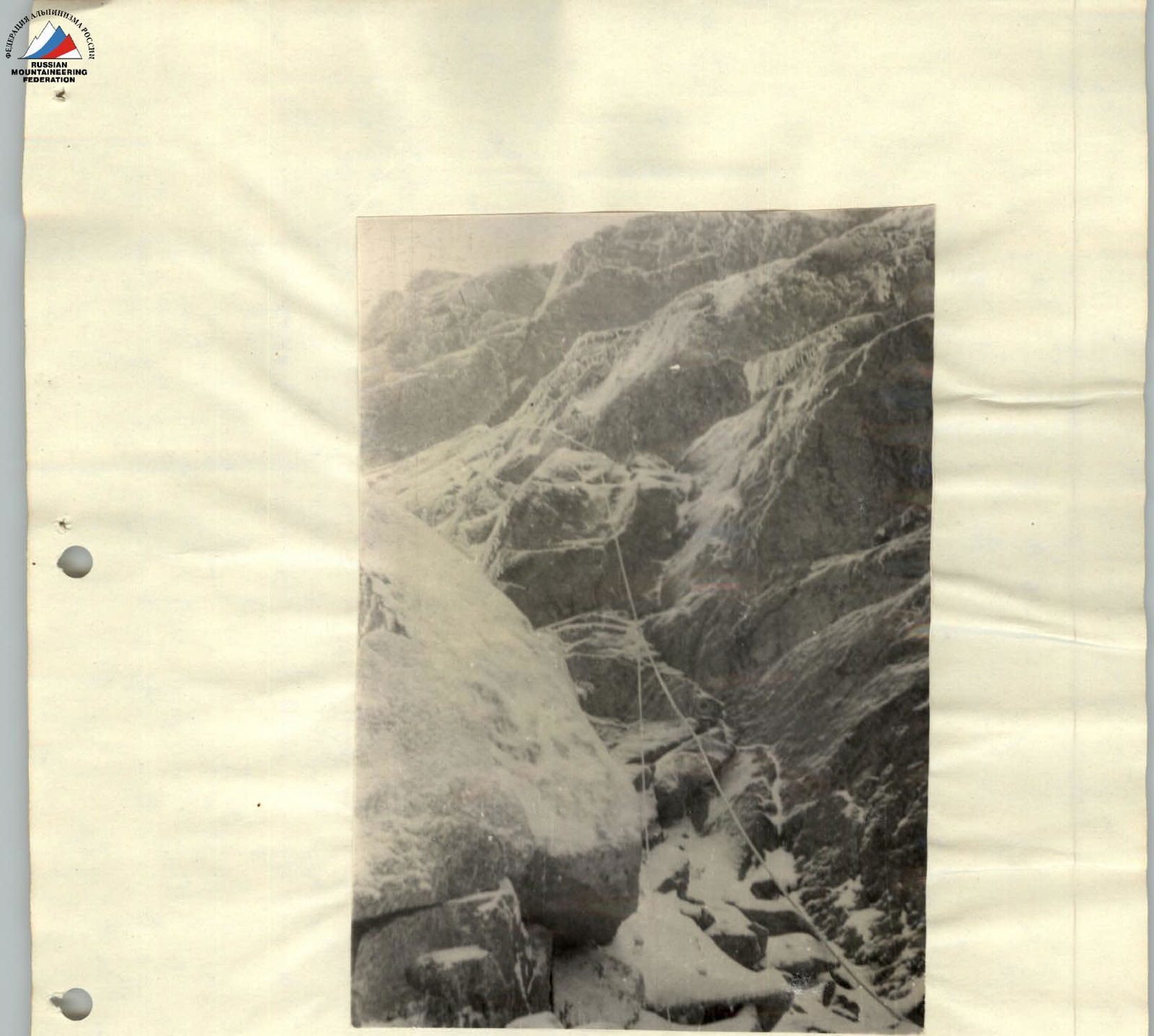
Section R0–R1
An inclined, rocky ledge along the left edge of the rocky promontory, 40 m, with a slope of 25–30°, followed by a 40 m ascent up a 50° couloir to the left and upwards. The exit from the couloir is blocked by an overhanging wall, 4 m high, where they hammered in the first pitons.
Section R1–R2
After the overhanging wall, they traversed a series of rocky walls, 4–5 m high, with ledges in between, using piton protection (total of 30 m), and reached the base of a 40 m wall.
Section R2–R3
A rocky wall, 75° steep, with vertical sections 2–3 m high (one rope length). The climbing was difficult. They hammered in pitons and pulled up their backpacks.
Section R3–R4
They ascended to the right and upwards, 40 m, via steep but not very complex, dissected rocks. The rocks were unreliable, so they moved cautiously and hammered in pitons for protection.
Section R4–R5
They reached a 60-meter couloir with a debris and ice floor, sloping at 45°. There were numerous loose rocks. They moved along the edge of the couloir, using belays via outcrops.
Section R5–R6
They exited the couloir via its continuation, formed by a vertical wall on the right and a smooth slab on the left. They climbed a 25-meter slab using friction, where there was a crack for pitons. The first climber ascended without a backpack, while the others followed using the rope as a handrail. The slope was 60°.
Section R6–R7
Above the slab, they ascended via an internal corner, 10 m, to a ledge, and then traversed left of a rocky wall, 20 m. The climbing was not complex, with alternating belays.
Section R7–R8
From the ledge, they ascended directly upwards via an 80-meter wall, with an average steepness of 75–80° and sections reaching 90° over 7–10 m. The climbing was very challenging, with a slight zigzag pattern. In the middle of the wall, there was a small inclined ledge. They pulled up their backpacks twice over 40 m. During the ascent, at 17:00, rain began, turning into wet snow by 18:00. At 19:00, they reached the ridge and, over 1 hour and 30 minutes, constructed a decent platform from rocks. Above them was a large rocky "finger," approached by a narrow couloir turning into a chimney.
20 August
Until 2:00, wet snow fell, which froze on the rocks by morning. The ascent under these conditions became significantly more complicated. Considering the time limit and the lack of a reserve day, they decided to wait until 9:00:
- If the weather was good, they would continue the ascent;
- If the fog persisted and there was no significant improvement, they would begin their descent.
By 8:00, the fog had cleared, the sun appeared, and the air warmed up quickly. They departed at 8:00.
Section R8–R9
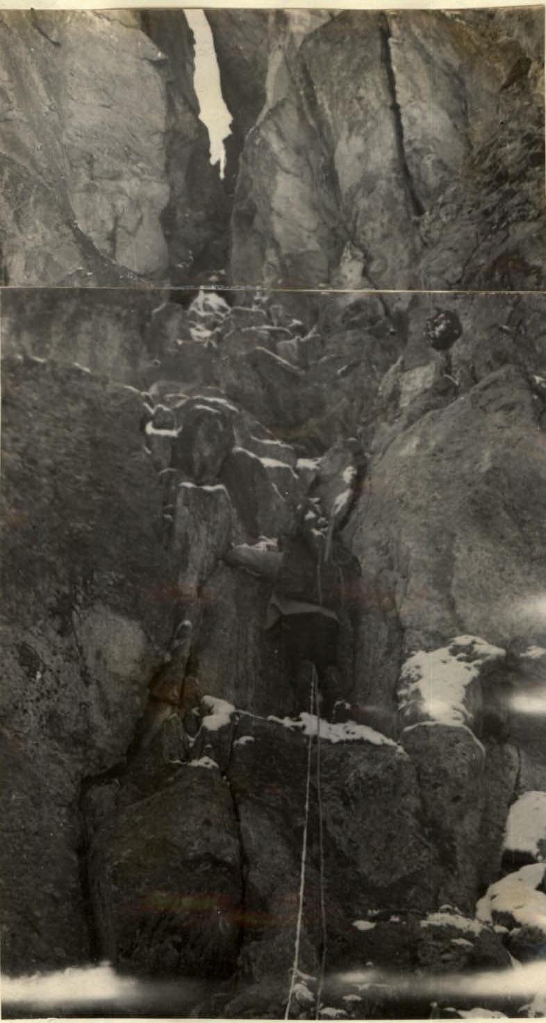
Still on snowy rocks, they ascended directly upwards via a steep, narrow couloir, which turned into a 20-meter vertical chimney, 0.8–1 m wide, after 40 m. The climbing was complex. In the chimney, there was a stone plug. They had to climb onto it and pull up their backpacks. They reached a saddle between the "finger" and the overhanging wall of the ridge on the right.
 Section R8–R9.
Section R9–R10
They ascended to the left and upwards, bypassing a large overhang via an 86° rocky wall, 20 m. The rocks had small holds, making the climbing very challenging. The first climber wore galoshes (there was no snow to the left of the ridge). Above the wall was a narrow ledge, followed by another 40 m wall with a small cornice, sloping at 80°. The rocks were concave, resembling a nearly vertical slab. The galoshes proved useful. In crampons, they would have had to climb almost entirely via ladders.
Section R10–R11
The wall led to a gentle ridge, 40 m. They traversed an excellent bivouac site. Beyond it was a straightforward descent to a snowy saddle and a 10 m ascent to steep, blocky rocks, leading to a sheer rocky wall. An attempt to bypass the wall via a snowy-icy slope and ledges was unsuccessful – everywhere were sheer and overhanging rocky walls. A more viable path was directly upwards and slightly to the right of the saddle level.
Section R11–R12
30 m of blocky rocks above the saddle, leading to the wall. The climbing was pleasant but quite complex. After the wall, they climbed with backpacks, using piton protection (3 pitons).
Section R12–R13
They began their ascent at the easiest part of the wall. In other areas, there were enormous overhanging walls. However, even here, the first 20 m were absolutely vertical, without holds, and with two overhangs, 1.5–2 m. There were no ledges or footholds. These 20 m were climbed wearing galoshes, using ladders multiple times, starting with a boost. Twice, they pulled up their "Zaltsug" bivouac gear. This key section took 2.5 hours. The remaining participants ascended with difficulty, using jumar ascenders. They pulled up their backpacks. Pitons were placed every 0.5–1.5 m. Above this section was a ledge, followed by another wall.
Section R13–R14
A wall, 80–85°, 40 m, with sparse small holds, led to the ridge. The climbing was very difficult but noticeably easier than on the previous wall: there were no ladders required, but they still climbed without backpacks.
Section R14–R15
Above the ridge, a wall overhung. They ascended to the left and upwards, 5 m, via rocky ridges protruding from the wall, to a ledge (two people could not fit): directly upwards via a sheer corner between a vertical slab on the right and a cornice on the wall to the left. The corner was 4 m, with extremely complex climbing. Further, they ascended a 20 m wall, 80°, and reached a wide, debris-covered ledge, where they bypassed a rocky tower on the left (10 m below its summit) and stopped at 19:00, lying down on the ledge before descending to a snowy, narrow saddle. From 17:00, a continuous fog reduced visibility to 15–20 m. At 18:00, they again failed to establish radio contact with the camp but managed to contact a group ascending Pik XXII Congress of the CPSU, led by M.S.V. Andreev, who had radio contact with the camp. Given that they were unable to reach the main ridge that day due to the high complexity of the final sections, and that they had only one day left for the final ascent and descent to the Ullu-Auya glacier, with the descent potentially requiring more time than crossing the summit, the group requested, through Andreev's group, an extension of the time limit by one day. Permission was granted and confirmed to extend the time limit by 1 day (until 12:00 on 23 August). They set up a platform under the rocky wall and reviewed their further route. Crossing the steep, 200-meter icy slope to reach the summit rocky tower was deemed illogical. Ahead of them lay a clear path: descent to a snowy saddle, 60 m of rocks covered in ice, and a snowy ridge, likely icy in its upper, steeper part. They fell asleep hoping that reaching the main ridge would take no more than 5 hours.
21 August
Section R15–R16
They departed at 6:00. After a short descent, they traversed a snowy, narrow saddle, 60 m, to a rocky outcrop. They used rocky pitons on both sides for protection.
Section R16–R17
They ascended rocky outcrops (70°, 15 m), covered in an icy crust – in the middle, a 2-meter vertical face was ice-covered – then to the right via a steep, icy couloir with step-cutting, and a 15 m rocky wall, 80°, upwards and to the right, 25 m: via steep rocks with good holds to a snowy ridge.
 Section R14–R15. Complex climbing on the rocky outcrop and the 15 m wall.
Section R17–R18
60 m of a steep snowy ridge. They climbed simultaneously. The ridge was wide, and protection was not necessary.
Section R18–R19
The ridge steepened significantly. On the first rope, the slope was 40–45°. The snow was no more than 5–7 cm thick; it was wet and slid off, exposing ice. The steepness quickly increased to 55° (4 ropes), with the first climbers using front-pointing crampons. They used piton protection. The final 80 m were practically an icy wall, up to 60–65°, with a thin layer of thawed snow – firn. They switched to step-cutting and screwed in ice screws every 12–15 m. Before reaching the main ridge, the weather deteriorated water fell, with rain and wet snow. They reached the ridge by 14:00. Visibility was poor. Along the ridge, they quickly traversed under the rocky wall of Pik Pioner, intending to ascend it immediately and descend through Bashy, but the rocks were already clogged with wet snow, and cracks were not visible, making the section challenging. Their clothing was thoroughly soaked. They were forced to set up a tent on a ledge below the wall, to the left of the ridge. They stopped at 15:00. At 18:00, they again lost contact with the camp.
22 August
Throughout the night, wet snow fell. On the ledges, there was already up to 40 cm of snow, and the snowfall continued, accompanied by strong winds. They decided to move, as they had to descend to the valley that day. They departed at 8:00, and radio contact was again lost.
Section R19–R20
A rocky wall, 65–80°, with a narrow ledge after 20 m. Everything was covered in snow. The climbing became not just complex but dangerous. They had to clear snow with their hands, and within 15–20 minutes, they were soaked through their windbreakers and down jackets. They climbed directly upwards (along the rocky wall) to a ledge, then to the right along it for 12 m, and upwards via another rocky wall for 18 m. They moved extremely slowly, hammering in pitons every 2–3 m. They pulled up their backpacks vertically to the snowy ridge.
 Section R18–R19. (Beginning of the ascent). Along the snow, 40 m – one rope length directly upwards to the summit. The snow was deep. At 13:00, the group reached the summit. Under the snow, they found a cairn and replaced the note.
Along the snowy, rocky ridge, they descended via climbing and rappelling to a saddle near Pik Bashy and, in the fog, followed the snowy ridge for 45 minutes to reach its summit. The further descent to the glacier, bypassing icy drops, and then to the fields beyond the glacier's moraine, where they stopped at 20:00, was due to darkness and a lost flashlight. At 18:00, they again lost radio contact.
23 August
At 4:00, they continued their descent. Ovsyannikov B. ran ahead without a load and arrived at the camp by 9:00. The others descended to the farm by 8:00 and arrived at the camp by 11:00.
Conclusion
The group ascended a new, complex route over 42 hours. This was the first ascent of Pik Pioner, not counting its traversal during the crossing of the Koshtan-Krest ridge. The route was very logical. The height difference from the exit from the rocks to the main ridge was about 900 m, and 80 m vertically from the ridge to the summit. The average steepness of the wall was -.
On the route, they hammered in 86 rocky pitons (including at least 30 wedges) and 18 ice screws during the ascent to the ridge via the icy slope. A faster ascent of the slope and the pre-summit tower might be possible with good weather in June, when the icy slope could be covered with snow up to halfway. The route is significantly more challenging than:
- the wall of Pik XXII Party Congress, 5B category difficulty (the group ascended it in 15 hours);
- Pik "Trud" via the western wall, 5B (21 hours);
- Glavnyy Tamar via the western wall (21 hours);
- Zapadnyy Dombay via the NW wall (19 hours);
- Pik Mechta (24 hours);
- and others.
Certain sections of the rocky walls were extremely complex and are rarely encountered on routes of this category. The group believes that this route corresponds to the complex 5B category.
Group Leader. V. Benkin.