Peak Oktabrenok via NW wall — 5B (3890)
The transition from the "green camps" of Dumala gorge via l. Ululu-Auz to the big rocky island, to the left of the buttress of p. Pioneer, takes about 1 hour.
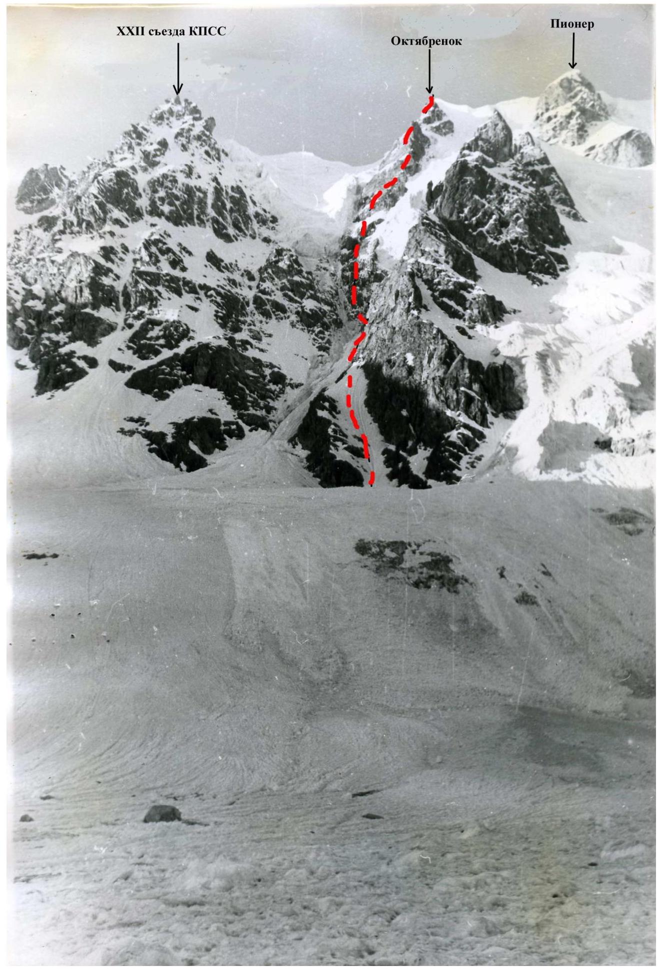 Ascent through the bergschrund and then up the steep snowy slope (50%) about 5–6 ropes to the right of the rocky island - the shoulder of p. Pioneer with an exit to its summit. Here is a safe place to spend the night and a good observation point.
From here:
- 2 ropes up to the right of the rocky tongue with an exit into the couloir
- 60 m of easy and moderate difficulty rocks along the couloir
- The next 80 m of moderate difficulty path should be traversed, rising gradually above the couloir by 8–25 m, partially using rocky ledges.
Insurance from the start of the entrance to the couloir is only крючьевая [hook] and very strict. Movement along the right wall of the couloir at a height of up to 25 m is quite reliably protected from falling stones and possible ice falls from the left glacier. The bend of the buttress of p. Pioneer protects from falling stones from the right.
It is from the bend that the dangerous sections begin, requiring clear, quick work, the section of transition to the lower part of the wall of p. Oktabrenok. On the day of reconnaissance and processing, the group worked on the route for 6 hours. The ascent path was processed up to the angle of turn of the right wall of the couloir. 120 m of rope were hung. 10 hooks were hammered.
Exit from the base camp at 3:00. Approach to the route — 1 hour. Ascent on the ropes hung the day before — 1 hour. Having gone beyond the corner of the buttress, without losing height, they traversed about 16 m to the base of a narrow rocky couloir-well, going to the right along the slope of p. Pioneer, where a hook is hammered. Further, on crampons, they traversed 40 m of the icy slope of the couloir. At the end of the couloir, they crossed a 5-meter groove. The steepness of the slopes of the traverse is up to 50%. Insurance is крючьевая [hook]. Mainly rocky hooks are used. The group did not knock out hooks on this section.
The rocks of the "triangular type" do not have easy sections. General direction (as the первовосходители [first ascenders] went):
- up through the center
- then along the right part to go around the first cutting щель-кулуар [crevasse-couloir] from above
- after that along the smoothed rocks-walls and slabs to the left.
Here the upper part of the shield is cut by the second relatively gentle (45°) snow-ice couloir. On this part of the island with a total length of about 4 ropes, 29 hooks were hammered.
From the lower point of the 2nd cutting couloir along its right rocky part (30 m) - transition to the right side of the wall. From here, 2 variants of further movement are possible:
- 20 m (45°) under the ice cliff and its bypass on the left along a narrow, very steep (up to 60°) ice couloir between the rocks and the serac
- or bypass it on the right.
The second path, due to the overhanging ice walls above, is apparently more dangerous. The group passed the first option, hammering 5 hooks on a 35 m section. The general direction of movement is up towards the right rocky protrusion. Here, under a 3-meter massive rocky awning on the snow, a night's stay was arranged.
On the same day, the next 60-meter snowy bypass of the upper part of the "shield" with a 7–10-meter ice section (2 hooks) was processed.
On the first day of ascent, the двойка [duo] worked directly on the route for 13 hours. Passed (counting from the bergschrund) 725 m of the route, 55 hooks were hammered, including the day of processing.
Along the path processed the day before - exit under the first rocky cliff. The overall steepness is over 75%. Only in the center (closer to the left part) is a suitable beginning visible: a smooth, slightly expressed внутренний угол [inner corner], going up to the right. The rocks are steep, smoothed, with minor ledges, the possibility of using artificial footholds, and забивка крючьев [hooking] is also limited. On the entire 80-meter ascent, the first one went without a backpack. Climbing was complicated by water flowing from the upper shelves. Occasionally, icicles and pieces of натёчный лёд [formed ice] fell from above.
The first cliff, as well as the even steeper up to 80°, second (120 m) and third (100 m) - ascents of the wall, representing very difficult, even for climbing in vibration without a backpack, often using ladders, невыраженные внутренние углы [unexpressed inner corners], vertical slabs, monoliths, навесы [overhangs], and other forms of relief. Climbing is more difficult than, say, on the route of F. Zhitenev along the wall of Bodon.
The second cliff was overcome closer to the center:
- at first along a 10-meter wide внутренний угол [inner corner] going up to the left
- an attempt to reach the right edge of the cliff was unsuccessful - the rocks here are even more complex
- then through a chain of нависающие льды [hanging ice] they reached and passed a steep (50°) 15 m long ice slope under the third cliff.
The length of the third cliff is about 100–120 m. The path along it begins with a difficult 25-meter section, ending with a навес [overhang], after which there is a наклонная полочка [sloping shelf]. From it:
- the path is up to the left, bypassing a large ledge
- further along a steep wet угол [corner] with "живые камни" [live stones].
Difficult place. The angle leads under a карниз [cornice] (extension 0.8 m), which is overcome in the left part with the help of лесенок [ladders]. After 10 m, there is a наклонная полочка [sloping shelf] facing p. XXII съезда [Party Congress] (30 m from the snow-ice ridge). On this shelf, a small platform for a tent is built. Working day - 10 hours. Hammered hooks - 84. The length of the route on this day is 380 m.
Ascent to the гребень [ridge] (30 m). At first, it is snowy, clearly expressed, but about a rope later it is interrupted by complex for climbing rocky жандармы-кубы [gendarmes-cubes], so the group was forced to go back to the left again:
- on the натёчный ледовый склон [formed ice slope] with separate exits of rocks (40 m)
- further to overcome a 60–80-meter wall of complex rocks, in places using artificial footholds.
About 10 m the first one climbed without a backpack. On the wall - "живые плиты" [live slabs]. The wall ends with an exit under the summit башня [tower]. In that place, there is a powerful triangular выемка [recess] in the massif, ограниченная плоскостями [bounded by planes]. Along the slab:
- ascent to the top of the triangle
- further along a 7–8-meter отвесная стена [sheer wall] (without a backpack) - exit to the гребень [ridge].
An attempt to go further along the rocky гребень [ridge] was unsuccessful: the rocks are smoothed, without cracks, almost no insurance points when overcoming the провал [dip] between жандармы [gendarmes]. Along the натёчный лёд [formed ice] (25 m), the group went along the rocks to the right, to the snowy предвершинный склон [pre-summit slope], along which (4 ropes) they climbed to the summit of peak Oktabrenok.
Before ascending to the summit, excluding the snowy slope, along which simultaneous movement is possible, insurance is exclusively крючьевая [hook] (16 pieces). The ascent to the summit took 4 hours on this day. The total length of the section is 315 m.
Descent along the хребет [ridge] Koshtan-krest towards пер. [pass] Koshtan and further to the "green camps".