Report on the ascent to the summit of Misses-Tau via the 5B category route by the sports group of the FASPb assembly
(Yu. Shevchenko's route, 1976)
Climbing passport
- Climbing category: Technical
- Climbing region: Central Caucasus, Mijirgi gorge
- Climbing route with indication of peaks and their heights: Misses-Tau peak 4427 via the right counterfort of the wall, combined, 5B category
- Route characteristics:
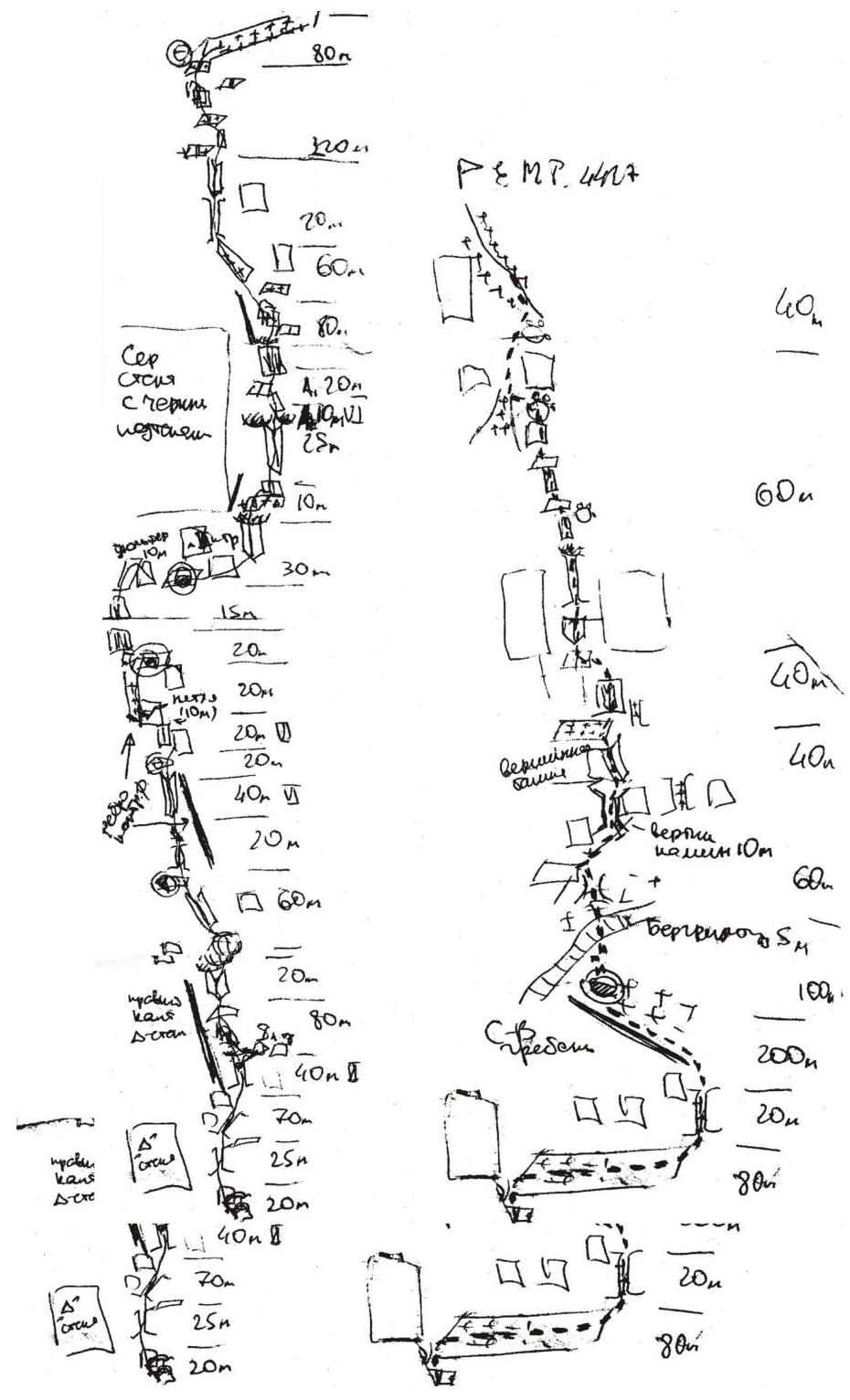
- Route length 1550 m
- Height difference 980 m
- Average steepness of the main part 85°, total 70°
- Length of sections with 5th category difficulty 650 m, 6th category 120 m
- Number of pitons:
- Rock pitons 0 (4)
- Ice pitons 0 (2)
- Cams 120 (15)
- Bolts 0 (0)
- Number of walking hours/days: 18 / 3
- Number of overnight stays and their characteristics:
- On a shelf, comfortable, lying down
- On a snowy ridge, comfortable, lying down
- Full name and qualification of participants:
Team leader: Ziderer Oleg V., 1st sports category. Participant: Viskov Igor Vladimirovich, 1st sports category.
-
Climbing date: August 23-25, 2005. Scheme UIAA
Climbing region and route
The Central Caucasus is the highest and most inaccessible part of the Greater Caucasus mountain system. The Bezengi region, part of this system, occupies a relatively small area between the Tviber pass and the Digor ridge. Nevertheless, its high density of peaks exceeding 5000 m above sea level and walls with a total height difference of 1500-2000 m makes it one of the most unique mountain regions in the world.
North of the Central Ridge, on the north side of the Bezengi glacier, lies the system of the Lateral Ridge, with six peaks exceeding 5000 m above sea level, four of which are located in this ridge. This is the main sports mountaineering massif in the region, forming a horseshoe-shaped cirque around the Mijirgi glacier.
The walls in the region are typically divided into northern and southern ones. Northern walls are usually:
- Snow-ice and combined,
- With steep rock bastions,
- With ice falls,
- With snow cornices.
Southern walls are predominantly rocky.
The Misses-Tau peak is located in the Lateral Ridge, in the Mijirgi glacier area. The peak's wall, facing the Mijirgi glacier, is practically 500 meters high.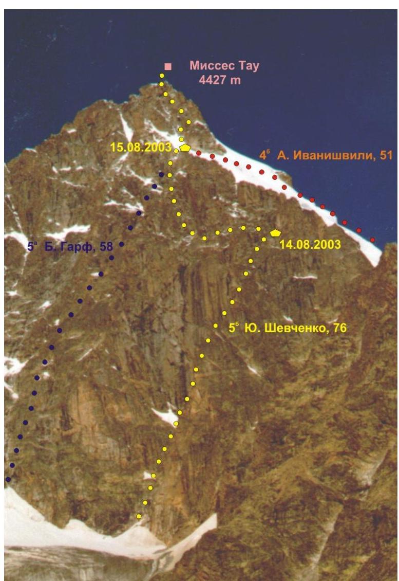
The wall is not fully visible from the glacier, as its lower part is obscured by a counterfort, and only the upper part is visible. The wall is oriented eastward, so it is lit by the sun almost all day in good weather. Closer to evening, if there is snow on the ledges, streams run down the wall. During our ascent, there was no snow on the ledges and, consequently, no streams.
The journey from the "Bezengi" tourist camp to the initial bivouac, located in the lower cirque of the Mijirgi glacier, takes an average of 2-3 hours. From the second "football fields" along the "green" trail, there is an exit to the "Moscow" overnight stays. From these overnight stays along the boundary between the moraine and the glacier to the "ram's foreheads" - there are three of them. Climbing up the ledges of the central "ram's forehead" leads to a scree slope, and at the top of the scree slope, there is a small platform - the overnight stay location.
From the intermediate camp on the second "football fields" to these overnight stays takes 2-3 hours. From the overnight stays to the start of the route takes 40 minutes.
The route begins to the right of the snow-ice couloir and initially leads into the cirque under the wall, then:
- goes out onto the right counterfort of the eastern wall from the cirque side;
- follows along the counterfort to its very end;
- crosses the wall from right to left in its upper part;
- goes out onto the northern ridge, leading to the summit tower;
- further coincides with the Ivanishvili route (4B).
- Departure from "Bezengi" tourist camp: 7:30 August 23, 2005.
Departure onto the route: 13:00 August 23, 2005. Summit arrival: 10:00 August 25, 2005. Return to "Bezengi" tourist camp: 19:00 August 25, 2005.
Climbing debriefing materials
Attendees:
Saratov Yu. S. - head of the region's KSP, Lobachev E. A. - climb leader, Klepcha I. V. - climb participant, Koltunov O. S. - climb participant, Kondratovich M. V. - climb participant
Lobachev:
We departed at 6:00 to the route
August 14:
- At 7:00 we contacted from the bergschrund
- At 10:00 we were halfway up the rope from the counterfort
- At 13:00 we approached the overnight stay area near the "Petushiny Grebny" ridge
- The group departed from the camp on August 13 at 11:00 and arrived at the overnight stay under Misses-Tau at 17:30.
- At 16:00 - at the control tour. We found a note from a Ukrainian group from Sumy (leader Mityukhin)
- At 19:00 - we were in the upper part of the counterfort. After 1.5 hours, we stopped for the night
The next day, we departed from the overnight stay at 7:00. It took about 1.5 hours to find the further path, as we went too far up under the wall. Then we returned to the overnight stay and went left along the ledges to the left counterfort and reached the shoulder by 13:00.
After 2 hours, we headed towards the summit. The group reached the summit at 16:40. We started descending at 17:00 and were back on the shoulder near the tent by 18:30. On August 16, we departed from the shoulder at 7:30 and descended to the flat part of the glacier by 10:00. We were at the second "football fields" by 13:00 and returned to the base by 16:30.
Koltunov:
We were very lucky with the weather. The weather was excellent throughout the climb.
Klepcha:
We liked that we hardly had to hammer in pitons - we only used cams and stoppers.
Lobachev:
One of the three ropes was damaged, so we only used two. The group worked professionally, and the climb is credited to everyone.