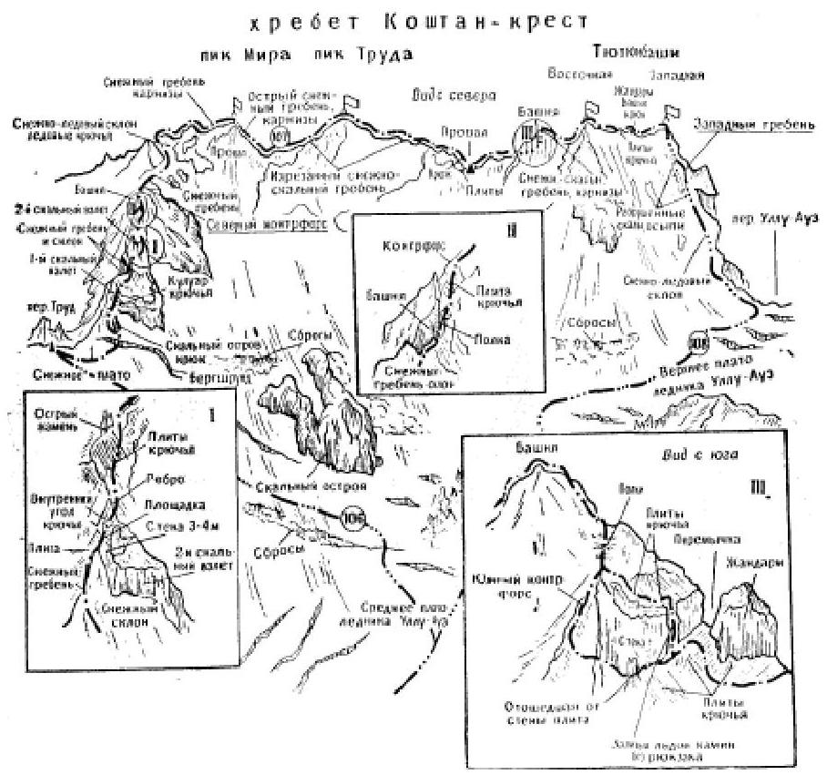
- Traversing the Kostan-krest ridge from Pik Mira to Tютюнбаши with an ascent to Pik Mira via the Northern counterfort - 4B category of difficulty (A. Naumov, E. Varfolomeev, I. Kudinov, E. Sokolovsky, V. Shutin, and V. Shutov - July 22-24, 1961; Fig. 36).
The path from the "Bezengi" alpine camp to Pik Mira is described in route 106. From Pik Mira, descend west along a 150-180-meter sharp snowy ridge (cornices!) and 80-meter steep rocks (sporting descent) to the saddle between Pik Mira and Truda. From the saddle, traverse 200-250 meters along a heavily jagged rocky-snowy ridge (cornices!) with 3-5-meter rocky and small snowy gendarmes, which are overcome along the ridge. After a 7-10-meter drop, ascend along a sharp snowy ridge, then along a slope that transitions into a 60-80-meter sharp snowy ridge with small rocky outcrops over 150-200 meters. Continue along rocks of medium difficulty and a snowy ridge to ascend to Pik Truda.
From Pik Truda:
- descend 25-30 meters along rocks of medium difficulty,
- then ascend to a small gendarme,
- from it, make a 40-meter sporting descent to a saddle.
Further:
- traverse along rocks of medium difficulty with many small gendarmes, which are bypassed along shelves or overcome directly along 2-5-meter walls and 35-meter slabs (hook!) - descend into a drop.
In the drop - a bivouac. From the Truda pass - 10-12 hours.
From the drop:
- ascend along a steep snowy ridge, alternating with rocks of medium difficulty, to a shelf under the wall of a rocky tower,
- from the shelf, make a 55-60-meter traverse along the slabs on the left side of the tower,
- then ascend to a narrow saddle (piton belay!), without reaching the saddle, move left under the wall to a vertical 7-meter chimney filled with ice (piton!),
- ascend the chimney (without a backpack!) to a slab (hook!) and along it 15-20 meters up to a shelf,
- further along simple and medium-difficulty rocks, ascend 70 meters to the top of the tower.
From the tower:
- descend along the ridge, bypass two small gendarmes on the right along steep snowy slopes,
- along a sharp snowy ridge (cornices!), descend to a saddle under the peak Vostochnaya Tютюнбаши.
From the saddle:
- ascend along a snowy, then simple rocky ridge,
- bypass the first gendarme along a snowy shelf on the right,
- the second - initially with a 15-20-meter traverse along a steep snowy slope on the left (piton belay!), then 20-25 meters up along difficult rocks of the Southern counterfort (hook!) - ascend to the top of the gendarme,
- from it, make a 10-12-meter sporting descent into a drop,
- bypass the next gendarme along a snowy slope and slabs on the right (piton belay!),
- further along a simple rocky-snowy ridge - ascend to the peak Vostochnaya Tютюнбаши.
From the bivouac - 7-8 hours.
From the peak:
- traverse along a horizontal simple rocky-snowy ridge,
- pass the first gendarme directly along 5-6-meter slabs on the left side (piton belay!),
- from the gendarme, make a 6-meter sporting descent,
- overcome the "Bashnya" gendarme directly along a 7-8-meter wall,
- descend from it with a 10-meter rappel,
- further along a simple rocky-snowy ridge, with small walls overcome directly or bypassed along shelves on the left or snowy slopes on the right - reach the peak Zapadnaya Tютюнбаши.
From the bivouac on the ridge - 9-10 hours. The descent along the Western ridge is described in route 108.
Recommendations for climbers
- Number of participants - 4-8 people.
- Initial bivouac - Truda pass.
- Departure time - 4-5 am.
- Equipment: main rope - 2×40 m; auxiliary cord - 5 m; rock pitons - 8-10; ice pitons - 3-4; rock hammer - 2; carabiners - 8-10; crampons - 4 pairs; tent - 1.
- Bivouac locations - on all peaks, drops, snowy ridges, and before the peak Zapadnaya Tютюнбаши.