Technical Data
- Climbing Area Central Caucasus, Bezengi gorge
- Peak
- East Mizhirgi 4950 m
- West Mizhirgi 5050 m
- Route
- Ascent to the North Edge via the wall of the lower rocky bastion (first ascent)
- Along the North Edge to East Mizhirgi via Pelevin's route
- Ascent to West Mizhirgi
- Climbing Category technical
- Team ITMO Sports Club St. Petersburg
- Leader
- Team Members Veiko D.V., 1st sports category Runichev S.I., 1st sports category Chernikov A.A., 1st sports category
- Team Coach Kolchin A.A., Master of Sports of Russia International Class
- Route Characteristics
Ascent to East Mizhirgi:
- height difference — 1850 m
- length — 2550 m East Mizhirgi — West Mizhirgi:
- height difference — 100 m
- length — 550 m
- Challenging Sections
- V category of difficulty — ~300 m
- VI category of difficulty — ~100 m
- Overnight Stays
- lying down — 3
- semi-reclining — 2
- Number of travel hours/days to West Mizhirgi 54/5
- Belay Points
- rock anchors — 40
- ice anchors — 20
- chocks — 70
- friends — 40
- Weather Conditions Satisfactory
- Dates Departure on the route — July 29, 1999 Summit of West Mizhirgi — August 2, 1999 Return to camp — August 4, 1999
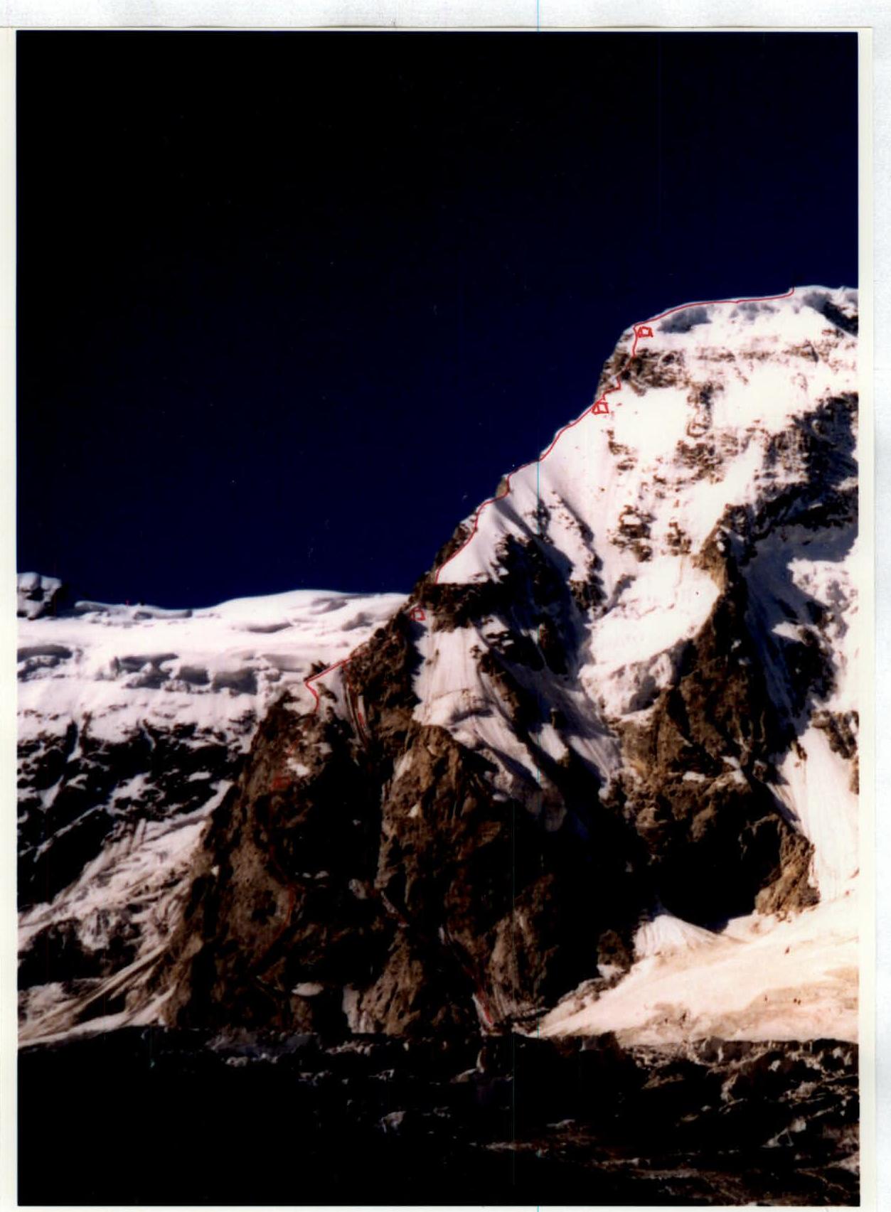
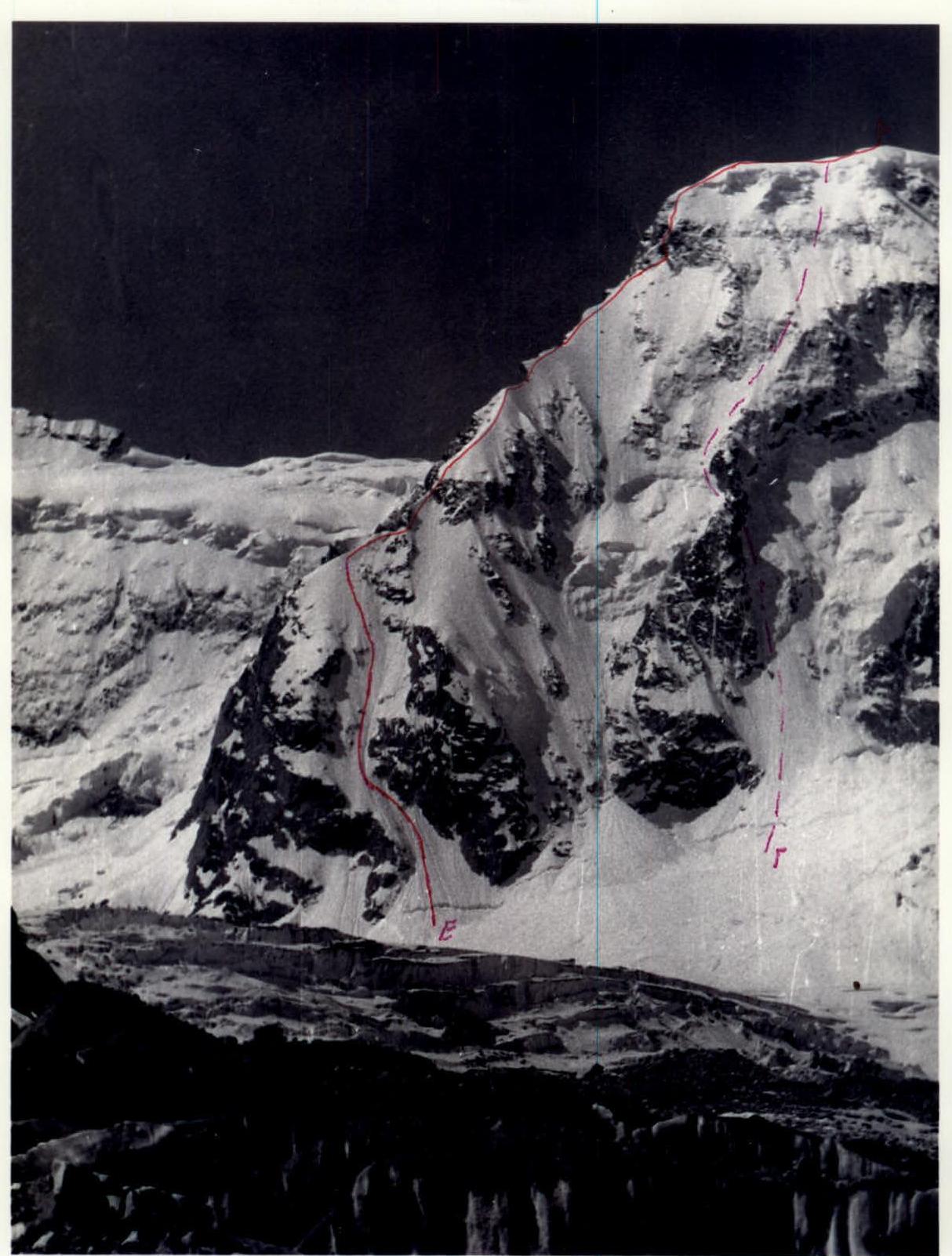
- Pelevin's route
- variant of exit to the edge, passed by the group
- overnight stay locations
- Photo of the North Edge of East Mizhirgi, taken in 1992. Shown for comparison of snow cover.
- Pelevin's route
Content:
- Climbing Description:
- Wall of the lower rocky bastion (first ascent),
- North Edge,
- East Mizhirgi — West Mizhirgi.
- Climbing Analysis Protocol.
- Route Map.
- Copies of summit notes.
- Communication Log.
Climbing Description
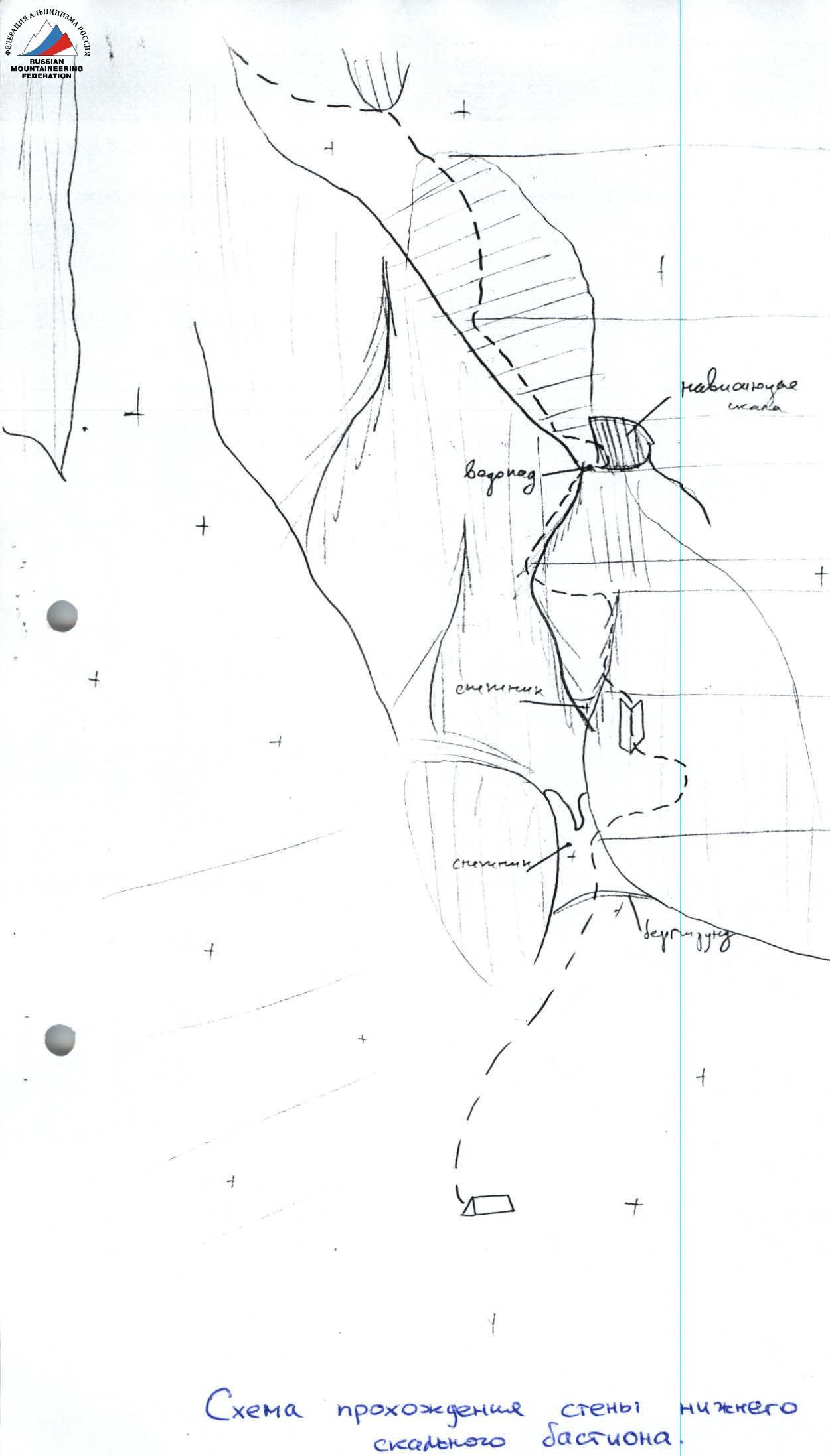
Wall of the Lower Rocky Bastion (First Ascent)
The initial bivouac is set up on the Mizhirgi glacier at the base of the rocky bastion of the North Edge of East Mizhirgi (3100 m). The location is chosen with consideration of the rockfall hazard from the towers of the icefall descending from the slopes of the Krumkol-Mizhirgi ridge to the left of the North Edge.
Day 1 (July 29, 1999). Departure — 7:00. Approach to the route takes 40 minutes via snow, avoiding crevasses. The morning approach to the route is on snow with crampons and does not require belaying. At the base of the rocky bastion, there is a characteristic forked snow patch. From the bivouac site, approach the right branch of the snow patch and, without reaching its end, exit right onto the rocks.
- Section A–B. Length 150 m, slope 50°, category of difficulty III. System of ledges overgrown with grass, an internal angle 25–30 m.
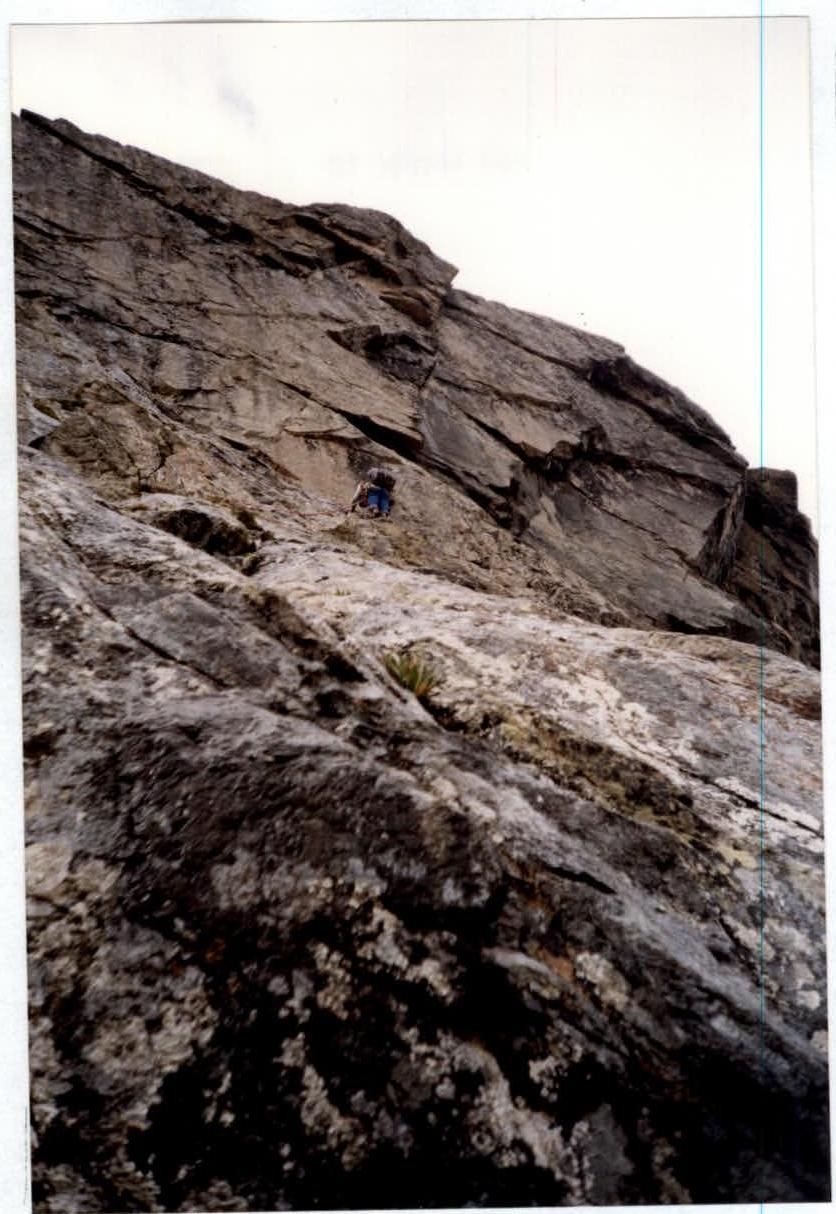
- Section B–C. Length 100 m, slope 70°, category of difficulty V. Monolithic rocky ridge, sometimes sharp, leading to the main wall. Belaying — anchor.
- Section C–D. Length 80 m, slope 60°, category of difficulty IV. Traverse left along the wall on ledges overgrown with grass.
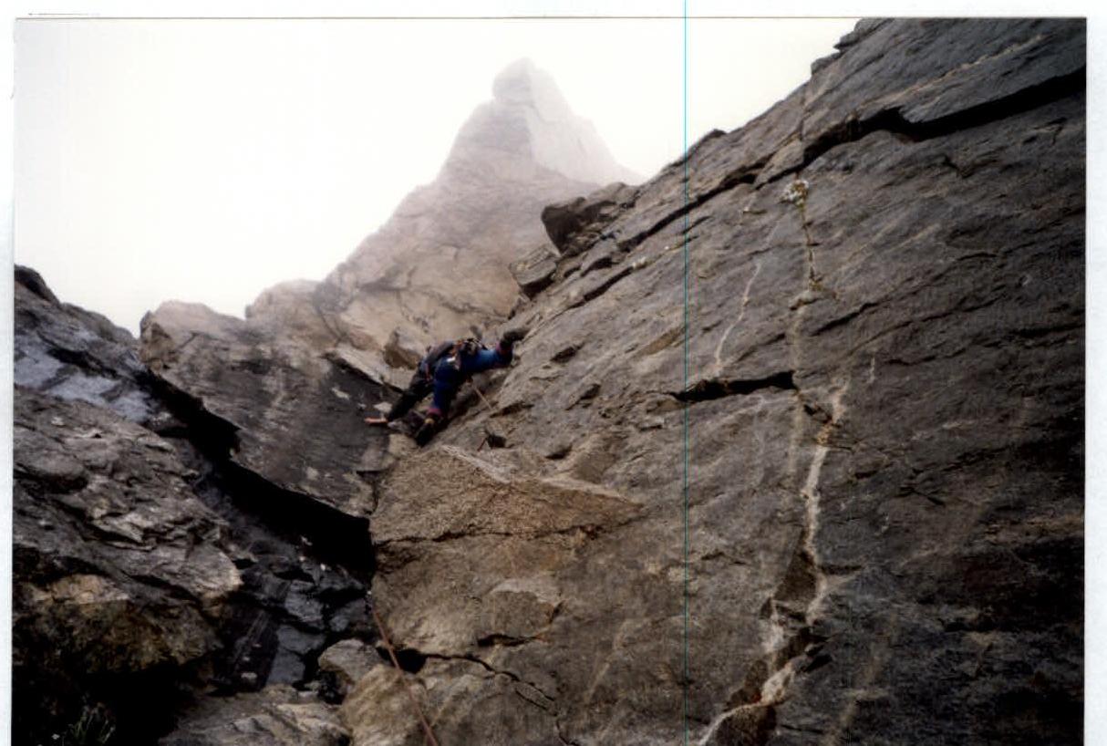
- Section D–E. Length 100 m, slope 80°, category of difficulty V. Along the couloir on a vaguely expressed vertical counterfort. Rocks are complex. The first climber goes with a lightened backpack or without a backpack. The section leads under a waterfall. Move right upwards, crossing the water flow, under an overhanging rock.
- Section E–F. Length 25 m, slope 90°–100°, category of difficulty VI.
Diagram of the passage of the wall of the lower rocky bastion.
On the rocky bastion. Section C–D.
On the rocky bastion. Section E–F.
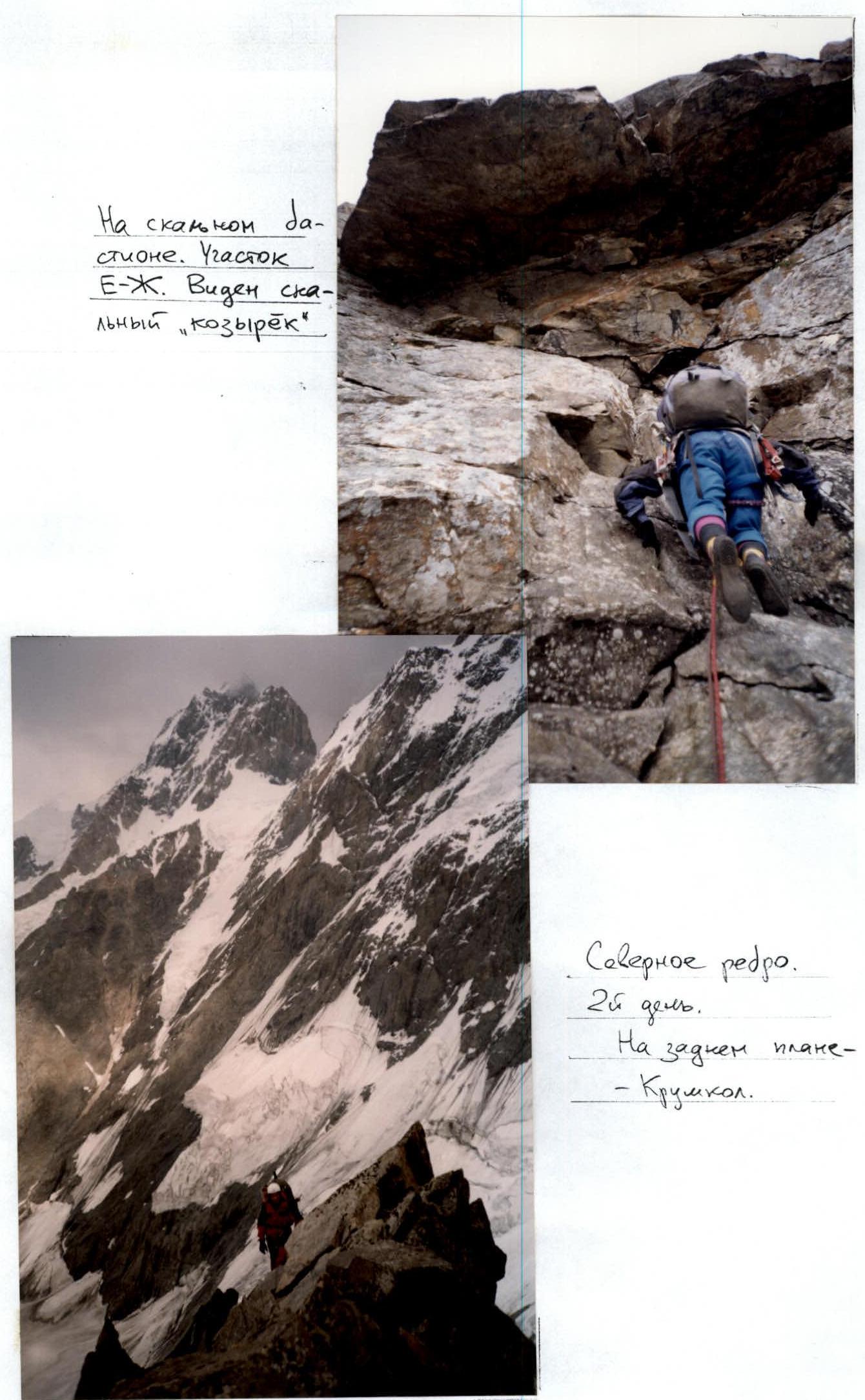
On the rocky bastion. Section F–G. A rocky "visor" is visible.
North Edge. Day 2. In the background — Krumkol.
 Challenging section. The first climber goes without a backpack. Wet rocks.
Section F–G
Length 70 m, slope 40°, category of difficulty III–IV. Move left upwards towards a flattening. At the end of the section — a rocky "visor". It is bypassed along its left edge. Challenging climbing 15 m (category of difficulty VI, slope 80°). After the "visor" — a lying-down overnight stay.
Stop at the bivouac — 20:00.
Day 2 (July 30, 1999). Departure — 8:00.
- Section G–H. Length 180 m, slope 40°–45°, category of difficulty III. Uncomplicated rocks. Simultaneous movement with anchor belaying is possible. Move left upwards. A stream serves as a landmark.
- Section H–I. Length 120 m, slope 50°, category of difficulty IV. Movement on ice under a rocky island. Then traverse left to exit onto the North Edge. There is a risk of rockfall (especially in sunny weather) due to thawing. Ice is soft, with firn in places. On the edge, a bivouac can be organized.
Further, the route proceeds along Pelevin's path.
North Edge
- Along a gentle snowy ridge to the first rocky gendarme — III category of difficulty 150 m.
- Bypass the gendarme on the right along destroyed rocks along the boundary of rocks and snow — III category of difficulty 50 m.
- On the right side of the gendarme, exit onto the ridge — III–IV category of difficulty 30 m.
- Rocky ridge — III category of difficulty 80 m.
- Bypass the second gendarme on the right and vertically upwards along an internal angle — IV–V category of difficulty 60 m.
On this section, there are many places for overnight stays in the hollows between the gendarmes.
Stop at the bivouac — 18:00.
Day 3 (July 31, 1999). Departure — 8:00.
- Along the rocky ridge to the exit onto a clearly expressed snowy slope. Rocks are covered in ice — IV–V category of difficulty 300 m.
- Bypass a rocky gendarme on the right and exit onto an icy ridge — IV category of difficulty 400 m.
- Along a snowy-icy ridge under a belt of rocks called the "Ice Room" — IV category of difficulty 120 m.
Stop at the bivouac — 21:00. Overnight stay is semi-reclining.
"Ice Room"
Day 4 (August 1, 1999). Departure — 9:00.
- From the ridge, right upwards in the direction of the icy couloir — IV–V category of difficulty 50 m.
- Along the icy couloir under overhanging ice — IV category of difficulty 50 m.
- Along the internal angle formed by overhanging ice and a rocky wall, to the exit onto a flattening. Challenging section — VI category of difficulty 40 m.
- Then right upwards to the exit onto a steep snowy-icy slope. Rocks are heavily snowed, with ice crust in places — IV category of difficulty 80 m.
Along a steep snowy-icy slope to the exit onto the North Edge. Deep powder snow lying on ice. Movement with belaying via ice anchors — IV category of difficulty 200 m.
Stop at the bivouac — 19:00.
Day 5 (August 2, 1999). Departure — 9:00.
Along a snowy-icy ridge, exit onto the summit fields of the East Mizhirgi massif about 300 m. Further along a small plateau, almost without gaining height, approach under a rocky gendarme. The gendarme is passed on the left. Uncomplicated rocks (25 m). Then also without gaining height, approach under the summit ascent. Along uncomplicated rocks (20 m), exit onto the summit of East Mizhirgi (around 12:00).
East Mizhirgi — West Mizhirgi
Further movement along a snowy ridge to the rocky tower of West Mizhirgi about 300 m. Traverse left downwards in the direction of the South Ridge along a ledge (30 m). Here is a place for an overnight stay. We set up a tent. The ascent to West Mizhirgi occurs from the south along an icy couloir. From the overnight stay locations to the couloir — traverse 40 m. Then ascent to the summit 120–150 m, rocks IV–V category of difficulty.
Exit onto the summit — 16:00. Descent to the bivouac. Stop at the bivouac — 17:00.
Day 6 (August 3, 1999). Departure — 9:00.
Descent along the couloir, going right (downhill) from the South Ridge of West Mizhirgi.