Lalver – Gestola, traverse, 3B cat. diff. The red dotted line is the ascent route. The blue dotted line indicates the 4A route. The black dotted line indicates a possible emergency descent option, the route is unclassified.
Green labels — overnight stops.
- 4 — Chyornye Osypi bivouac.
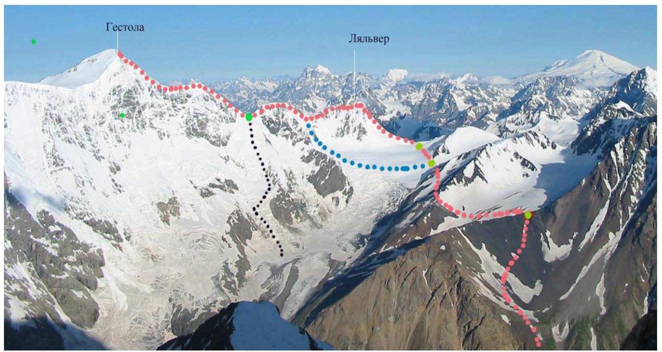
1. Ascent to Gestola peak via Lalver
Gestola peak (4850 m) is located in the Main Caucasian Range, in the Bezingi Wall.
Ascent to Gestola via Lalver is classified as 3B cat. diff.
The route is mostly snowy.
Route Description
Day 1
From the "Bezingi" alpine camp, the path goes up along the trail, along the right (orographically) moraine of the Bezingi Glacier to Mises-Kosh. At the southern end of the Mises-Kosh clearing, one should descend to the glacier and cross it diagonally, exiting to the left-bank moraine. Further movement along the moraine occurs up to a small lake, after which one should turn right and ascend the steep talus slopes of Kel-Bashi. Approximately to the west, keeping direction towards the saddle in the ridge connecting Salygan-Bashi and Kel-Bashi. A bivouac is set up on this saddle. The path from the "Bezingi" camp takes approximately 8 hours.
Day 2
From the bivouac, one should descend to a small glacier and cross it, slightly veering left along its course. Then one should cross the ridge limiting this glacier from the West and exit to the Tsanner Plateau of the North-Western branch of the Bezingi Glacier. The ascent to the N.Tsanner pass, north of the plateau, is made along a snowy slope. From here begins the path to Lalver. It passes through a snowy depression to the right of the ridge descending from the peak's rocks to the glacier. At the end of the ascent, easy rocks lead to the summit.
Descent from Lalver and ascent to Gestola occur along the ridge connecting both peaks.
When moving, one should stay on the right side of the ridge, but not too far to the right. The first ascent of the ridge with rocks is bypassed on the left, without exiting onto the rocks. The second steep ascent (the so-called "Nameless peak") is overcome head-on. Behind it, there is a snowy depression. Here it is advisable to set up a bivouac.
Day 3
From the bivouac, one sets out lightly. The ascent goes along steep snow to Gestola's shoulder. Further, one should traverse the slope to the right and upwards, exiting to the bergschrund. The latter is crossed at the southern edge. The further path to the summit goes:
- from the south along the snowy ridge
- along easy rocks
A cairn is located in the rocks on the south side, below the summit. Descent from Gestola is made along the ascent path. In the snowy depression, the bivouac is dismantled, and the group moves further through Lalver. On the same day, one can reach the N.Tsanner pass, where a bivouac is organized.
Day 4
Further descent is made along the ascent path, and return to the camp.