Cat. diff. 2B
92
Report
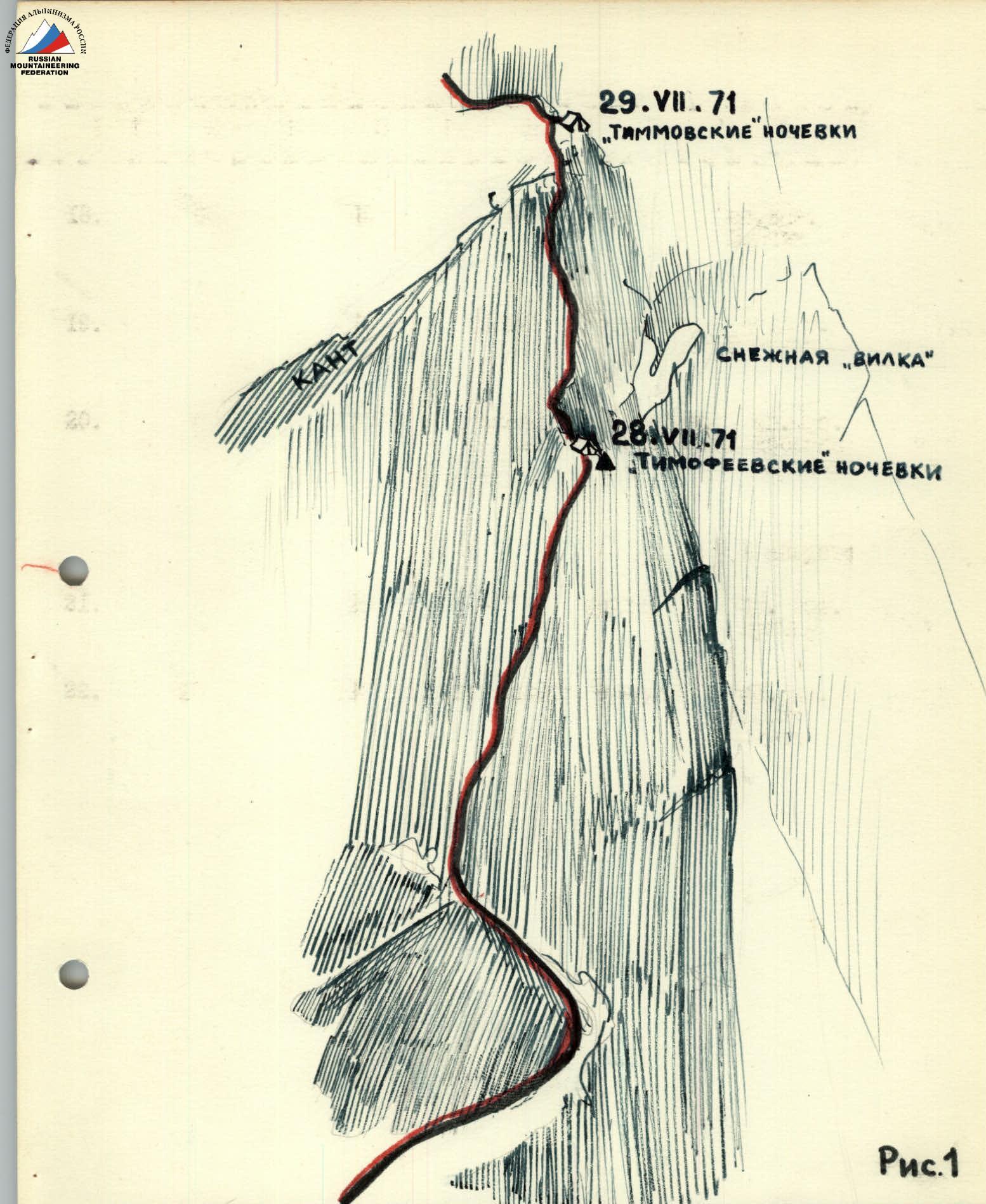
on the ascent of the "Tsey" team to the "Krumkol" summit via the northern wall


Route Description
1. First day. July 28
To the left of the rocky island and the avalanche chute, two bergschrunds are overcome via the avalanche cone. Then, up the snowy-icy slope, whose steepness gradually increases. Movement towards the rocky island and, bypassing it to the left, up the 40–45° slope to beneath the first wall. The wall is bypassed from right to left along a snowy-icy slope with an exit onto a snowy ridge. Along the snowy ridge turning into an icy slope that bypasses the lower part of the wall on the right, we ascend 30 m to an icy saddle with a steepness of 40–45°. From the saddle, a 40–45 m traverse to the left and upwards onto a snowy shoulder beneath the first wall.
Then, along narrow ledges on the slabs for 30 m to a small saddle to the right and upwards. From the saddle, 25 m upwards leads to a corner. Insurance is via pitons and rock outcrops. It is necessary to:
- hammer in pitons to create artificial footholds.
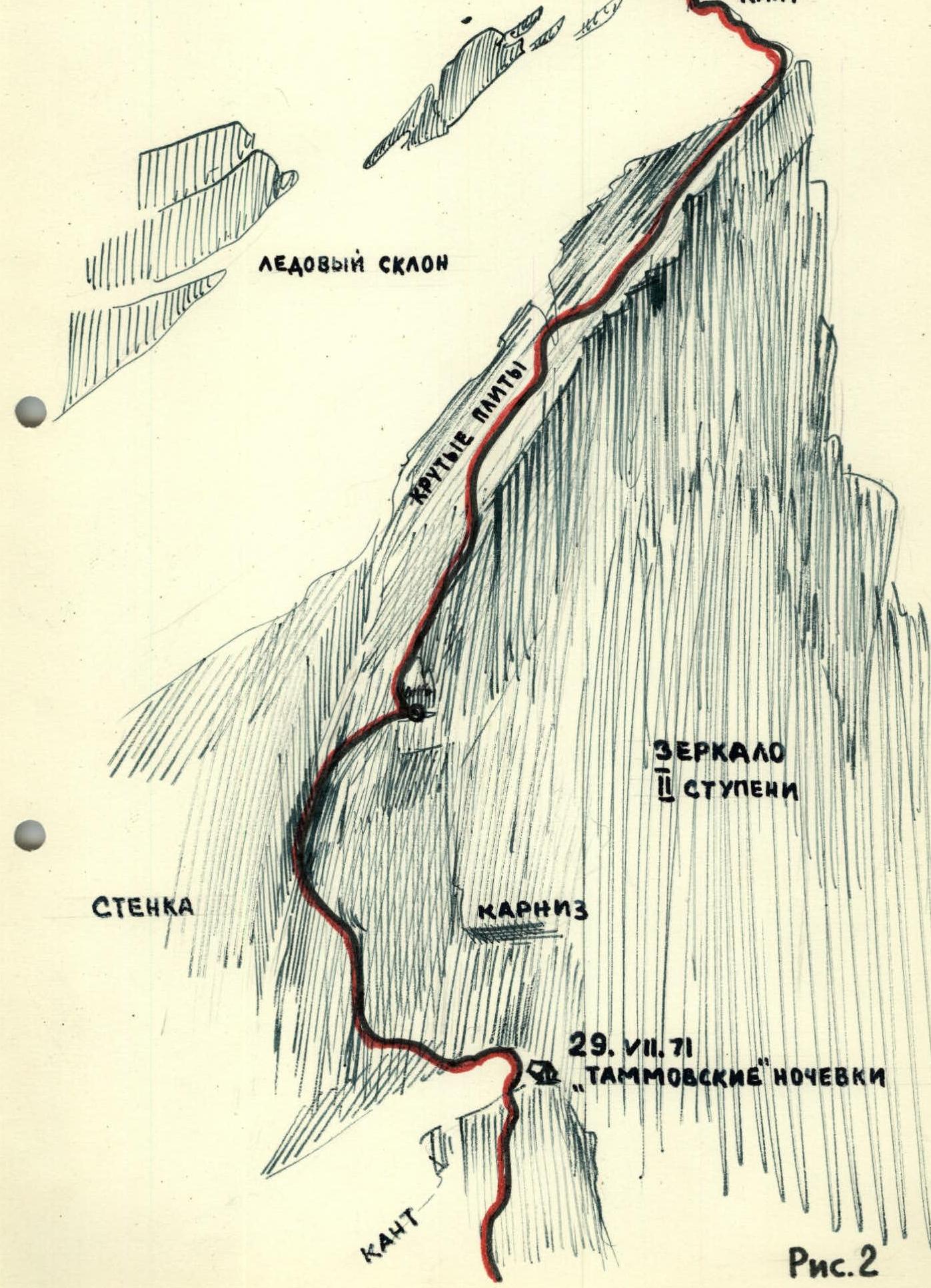
Up the corner, the rocks are covered in ice and snow. In the middle of the corner, there is a ledge onto which a loop can be thrown for insurance. The inner corner turns into a chimney covered with flow ice (30–40 m). Ahead lies the key point of the 1st day — a chimney turning into a crack. Pulling backpacks through here is impossible, and despite very difficult climbing, we have to ascend with backpacks (Fig. 1).
We move along the right rocky wall of the gully. Then, the gully turns into a 15 m chimney with a steepness of 40–45°. Along the chimney, we transition into a crack that goes to the left and upwards at an angle of 35–40°. After 5–7 m, the crack opens up onto a group of sharp rocks, from where we move, bypassing a large protruding rock on the right. Climbing is of maximum difficulty. Insurance is only via pitons. Often, we have to flatten ourselves against the slabs with our entire body or, using a rope, swing like a pendulum from one foothold to another. The backpack is very hindering, but it cannot be left behind. Having bypassed the smooth "plug" on the right, we exit onto an inclined slab. Along the inclined slab with a dual slope, we move towards a small step before a wall that goes 10 m upwards. Above the step, 1 m higher, there is a narrow ledge that goes to the left from the corner formed by 2 m walls. Along the ledge to the left for 3 m. Then, along an inconspicuous crack for 4–5 m. 1.5 m above, on the wall bordering the slab on the left, a sharp rock protrudes. From it, upwards and to the right to a "pocket" in the wall, then to a protruding rock and through 3–4 m onto a narrow ledge going upwards along the wall. On the ledge, there is a control cairn. (Passing this section takes 3 hours). Then, movement is along a rocky ledge with ice at a steepness of 35° onto a snowy slope (a bivouac is possible). Straight up, under 80°, a "rusty" monolithic wall ascends, turning to the right into a semblance of a ridge, behind which a black ridge of rocks can be seen steeply ascending.
To the left, along the wall, a crack goes upwards, turning into a chimney. Organizing insurance via outcrops, we move along the crack to a protruding rock for 8–10 m. Then, the crack turns into a vertical chimney with a rock "plug" in the middle, which is bypassed on the left along the wall. Above the "plug", 3 m higher, there is a ledge through which insurance can be organized. In the upper part, the chimney turns into an icy gully with protruding rocks.
Then, along a ledge in the direction of a large yellow rock, from the rock — to the right along a ledge with a steepness of 45°, 30 m upwards. At the end — a 4 m wall leading onto a ridge-edge of the wall. (Overnight stay).
Then:
- first, upwards under an overhanging rock for 10 m;
- then, traverse to the left towards a chimney for 15 m.
The bottom of the chimney is filled with flow ice. We exit onto a wall with a steepness of 50° and along the wall — towards a couloir for 30 m, then along its left side upwards, cutting steps in the ice and clearing the left wall to find footholds and places to hammer in pitons.
Approximately from the middle of the couloir, a semblance of a ledge goes off to the right, at the end of which it is easy to organize an overnight stay. "Work time — 15 hours".
2. Second day. July 29
The path goes upwards along the couloir to a crack, from here 7 m — to a heap of rocks forming a semblance of a ridge in the snowy-icy slope beneath the second wall. Along the crack, we approach a snowy-icy slope with a length of 10 m and a steepness of 35°, with individual rocks embedded. Then, there is a wall that ascends almost vertically. No cracks or ledges are visible.
From the site (apparently, the overnight stay of the Tamm or Chunovkin group):
- traverse to the left and downwards;
- below — two rows of pitons without a ladder;
- very carefully, we move in traverse towards a large detached rock.
Climbing is of maximum difficulty. In the upper part of the talus, it becomes somewhat easier as an winding crack appears, into which three channel pitons are driven one after another.
Further:
- movement along a shift in the wall filled with ice — climbing is very difficult;
- on 20 m, 9 pitons are hammered in;
- another 40 m of climbing with step-cutting and hanging two ladders;
- a smoothed corner (shift) leads to a ledge.
Then:
- along the ledge towards slabs covered in snow and ice;
- towards "rusty" rocks;
- for 30 m — pitons are hammered in;
- a place is organized for lifting backpacks (Fig. 2).
Then, along a snowy-icy slope, having first overcome snow-covered slabs with a steepness of 40–45°. The length of the slope is 150 m. It is passed diagonally to the right, bypassing a rocky island (20 m). Leaving the island to the left, along a 45° slope — exit onto a saddle. (Site for overnight stay. Total time spent is 11 hours 00 minutes).
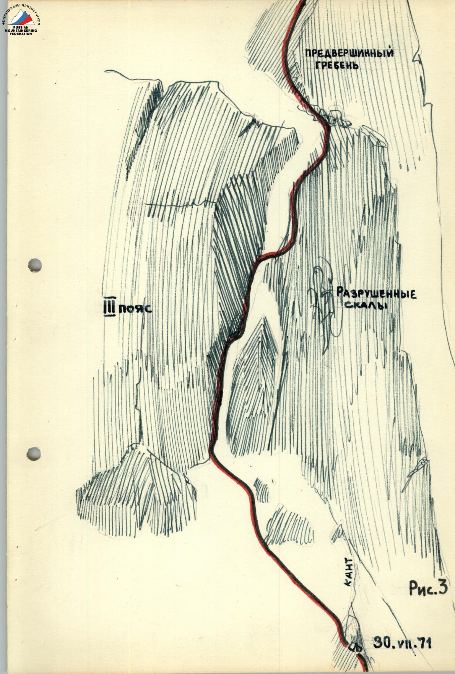
3. Third day. July 30
First, straight up along the junction of the walls, something like a snowy-icy ridge with steep rocky sections where we have to climb with maximum effort. Then, to the left and upwards in the direction of a large overhanging rock, and, bypassing it on the left, into an icy couloir with a smooth icy "forehead". We have to cross the ice twice, both times stretching out in a split and hanging on pitons. We pull up the backpacks. Then, upwards — 25 m beneath a wall with a steepness of 40–50°, first snowy-icy, then rocky. To the right, below the ridge — a site with an overhanging wall to the left. (Overnight stay. Total time spent is 9 hours).
4. Fourth day. July 31
Climbing is difficult and very unpleasant as every foothold has to be cut out of the ice. From the overnight stay upwards towards the ridge along steep rocks for 30 m, along a 50° ridge-slope towards the wall, along a chimney with a steepness of 70° for 5 m along the right wall, traverse to the left. Another 4–5 m, and we approach an overhanging rock beneath the left wall. Bypass along steep ice to the right until a kink, which leads through 2 m onto a three-meter icy ridge abutting against the wall. To the left of the chimney — a bypass of the wall. Traverse along the wall to the left, we cross a section of the wall above the chimney, which ends here. Movement is in the direction of a decrease in the wall's height. Several meters upwards along difficult rocks and exit onto the decrease. Movement upwards is from one outcrop to another. Then, to the left and upwards — transition onto the next ridge of rocks. After 30 m — smooth slabs. On 25 m, 8 rocky and 3 ice pitons are hammered in, ladders are used. Steepness is 60°. After 35 m, we approach a rocky ridge that forms a 15–20 m rocky shift to the left. In it, a crack can be seen leading above the ridge. 8 m along steep flow ice to a detached rock and from it onto the rocky shift. To the left and upwards in the direction of the crack. The crack leads onto the rocky ridge with a steepness of 50–55°. With 30 m, two rocky islands are overcome.
Above, there is a slope, then after 40–50 m — an exit onto a bend in the slope. To the right — a narrow, short (3 m) snowy ridge with steep slopes. To the left — a 10 m saddle. Overnight stay is possible. Further along a 10 m snowy saddle to a 30 m wall with a steepness of 65°:
- ascent along a slab upwards for 3 m;
- traverse to the left onto the "forehead" of a ledge for 2.5 m;
- then onto a protruding rock;
- traverse to an inner corner and up it;
- then, traverse to the right and upwards for 7 m onto a ledge;
- from the ledge — onto a bend in the wall.
Beneath 45°, a group of rocky islands with snowy-icy saddles ascends.
- First island: along the edge of ice and rocks — 20 m upwards, traverse to the left.
- Further: to the right along ice for 5–6 m, then upwards along a ridge of rocks for 20 m towards a snowy saddle.
- 30 m along the snowy saddle to a large rock.
- From the rock — to the right and upwards towards a vertical slab with a height of 5–6 m.
- The slab is passed "en face" and leads onto a snowy slope.
From here, the main ridge of Krumkol is visible.
Above the slab, beneath 35°, a snowy slope ascends. After 70–80 m, we approach an inner corner. Its base is icy with a steepness of 35°, higher — up to 50°; in the middle, and then to the left — ascent for 20 m upwards. Then, to the left along rocks onto a snowy slope and after 30 m — exit onto the ridge of Krumkol. Overnight stay. Total time spent is 13 hours 30 minutes.
5. Fifth day. August 1
Along the snowy ridge, overcoming two "gendarmeries", in 2 hours 30 minutes, we exit onto the summit. Descent is via the route of category 3B on the Krumkol Glacier.
Overall Characteristics and Recommendations
On the Route
The northern wall of Krumkol is a slope with an overall steepness of about 60° and a length of about 1680 m.
The route is logical and diverse in forms of relief, including rocky and icy steep sections and snowy-icy slopes. This route is complex throughout and requires climbers to possess the entire arsenal of mountaineering techniques.
Initially snowy-icy, it transitions into couloirs and slabs filled with flow ice. A small section of a snowy-icy ridge and again a steep hundred-meter wall, then again slabs, dry and snow-covered, covered with a crust of ice or filled with water, especially in the lower part, and again:
- chimneys;
- couloirs;
- ice.
The overall steepness is around 60°, but many sections are close to being sheer. Significant difficulties in passing the wall are created by flow ice on slab-like sections of the route, which clogs all cracks, hindering climbing and insurance. However, almost the entire route is passed via free climbing, which increases its mountaineering value.
The route requires good physical and moral-volitional preparation and can be recommended to a strong team that works equally well on snow, ice, and rocks.
There are rockfall-prone sections on the route (above the "Tammsk" overnight stays after 10:00) that require increased attention: quick passage.
Considering the need for a large number of pitons, carabiners, and ladders, it is advisable to have lightweight equipment on the route.
Due to frequent rockfalls from the southern slopes of Krumkol, movement along the glacier on the descent should start as early as possible.
Backup and Observation of the Team
The team was backed up by the "Torpedo" team, whose captain, Belyaev Yu.S., followed behind the "Tsey" team. In addition, an observer was stationed under the route, who kept a detailed log and thoroughly documented the passage of route sections. Moreover, the "Bezengi" team, which ascended via the northwestern counterfort, and the judge for the Bezengi region, Comrade Zak P.S., were periodically present under the route.
Communication was maintained via:
- "Tokay" radio stations;
- duplicated by flares.
Signature
Team Captain
September 30, 1971
/V. Lavrinenko/
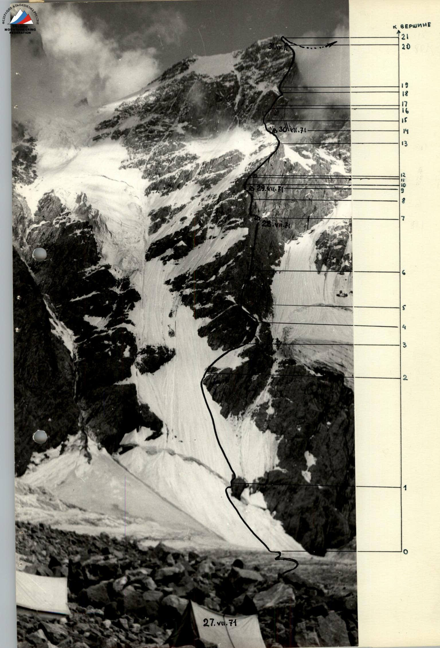
Legend
- ASCENT PATH
- OVERNIGHT STAY LOCATIONS
- CONTROL CAIRN
- SECTIONS OF BACKPACK PULLING
Table of Main Characteristics of the Ascent Route
Table of main characteristics of the ascent route to peak Krumkol via the northern wall (4676 m). Height difference of the route – 1680 m, including the most complex sections:
- rocky – 320 m;
- icy – 140 m.
Average steepness of the route – 61°, including the most complex sections:
- rocky – 86°;
- icy – 65°.
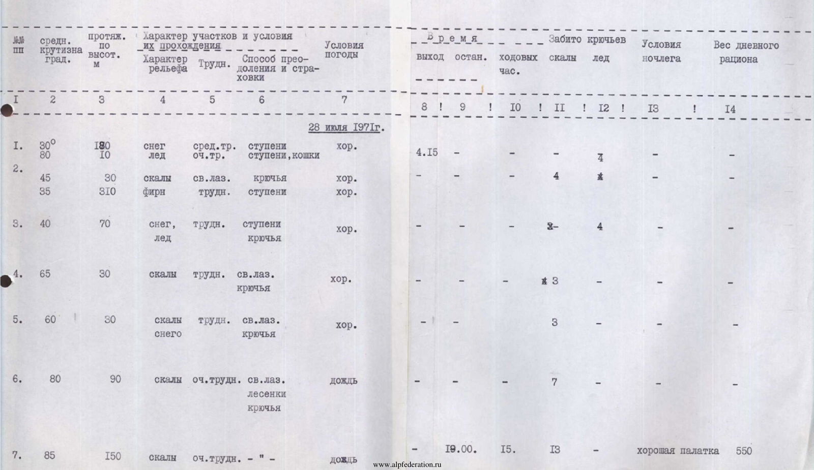
| № | Avg. Steepness, ° | Height, m | Character of sections and conditions of passage | Weather conditions | Time, h (start, rest, walking) | Pitons hammered in (rock/ice) | Overnight stay conditions | Daily ration weight, g |
|---|---|---|---|---|---|---|---|---|
| July 28, 1971 | ||||||||
| 1 | 30 / 80 | 180 / 10 | Snow, medium diff., steps / Ice, very diff., steps, crampons | good | 4:15 | |||
| 2 | 45 / 35 | 30 / 310 | Rocks, free clim., pitons / Firn, diff., steps | good | 4 | |||
| 3 | 40 | 70 | Snow, ice, diff., steps, pitons | good | 8 / 4 | |||
| 4 | 65 | 30 | Rocks, diff., free clim., pitons | good | 3 | |||
| 5 | 60 | 30 | Rocks, snow, diff., free clim., pitons | good | 3 | |||
| 6 | 80 | 90 | Rocks, very diff., free clim., ladders, pitons | rain | 7 | |||
| 7 | 85 | 150 | Rocks, very diff. | rain | 19:00 / 15 | 13 | Good tent | 550 |
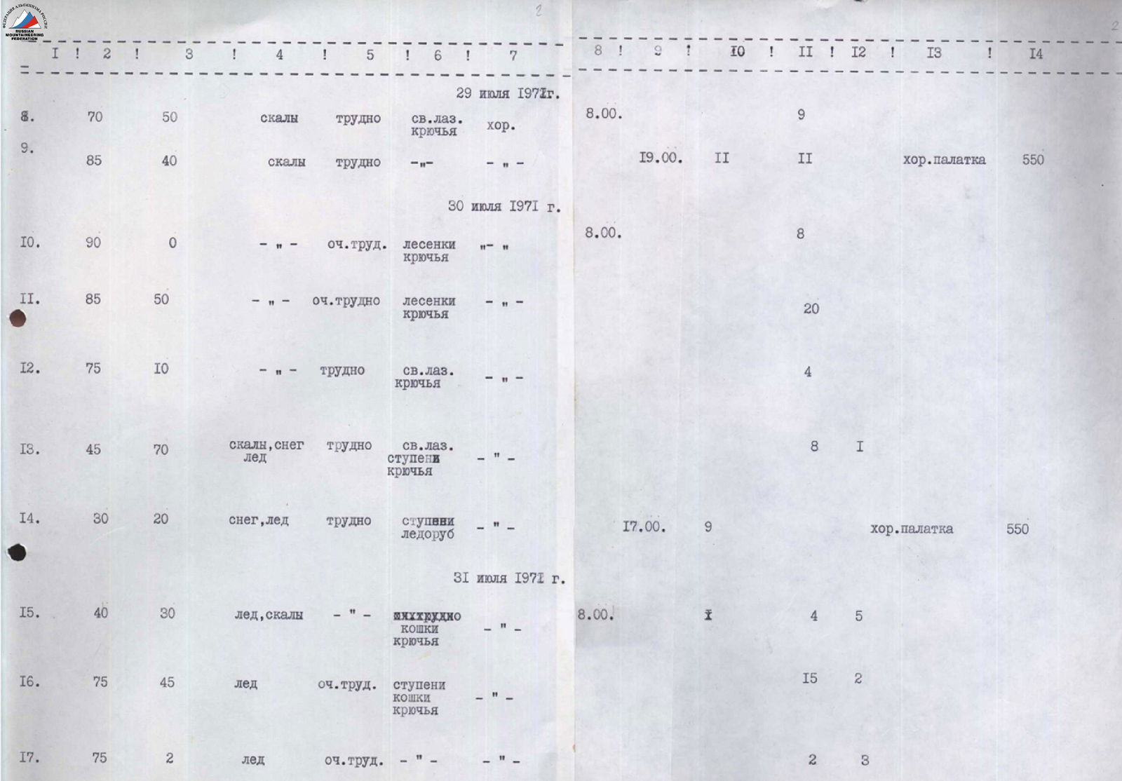
| July 29, 1971 | ||||||||
| 8 | 70 | 50 | Rocks, diff., free clim., pitons | good | 8:00 | 9 | ||
| 9 | 85 | 40 | Rocks, diff. | – | 19:00 / 11 | 11 | Good tent | 550 |
| July 30, 1971 | ||||||||
| 10 | 90 | 0 | Very diff., ladders, pitons | – | 8:00 | 8 | ||
| 11 | 85 | 50 | Very diff., ladders, pitons | – | 20 | |||
| 12 | 75 | 10 | Diff., free clim., pitons | – | 4 | |||
| 13 | 45 | 70 | Rocks, snow, ice, diff., free clim., steps, pitons | – | 8 / 1 | |||
| 14 | 30 | 20 | Snow, ice, diff., steps, ice axe | – | 17:00 / 9 | Good tent | 550 | |
| July 31, 1971 | ||||||||
| 15 | 40 | 30 | Ice, rocks, very diff., crampons, pitons | – | 8:00 / 1 | 4 / 5 | ||
| 16 | 75 | 45 | Ice, very diff., steps, crampons, pitons | – | 15 / 2 | |||
| 17 | 75 | 2 | Ice, very diff. | – | 2 / 3 | |||
| 18 | 60 | 45 | Rocks, diff., free clim., pitons | good | 4 | |||
| 19 | 30 | 18 | Rocks, medium, free clim., outcrops | Snow from 17:00 | ||||
| 20 | 65 | 210 | Rocks, snow, ice, diff., very diff., free clim., ladders, pitons | Snow | 20:00 / 12 | 38 | Sitting, covered with a tent | 550 |
| August 1, 1971 | ||||||||
| 21 | 65 | 30 | Diff., free clim., pitons | good | 8:00 | 10 | ||
| 22 | 15 | 190 | Snow, rocks, medium, free clim., steps, outcrops | Fog | 12:50 | 4 |
Reached the summit at 12:50. Total pitons hammered in on the route (not counting the descent) — 163 rocky, 19 icy. Total time spent on ascent is 51 walking hours and on descent is 18 hours.