Ascent Passport
- Ascent category — technical.
- Region — Central Caucasus, Bezengi region.
- Peak Krumkol (4640) via the Central Bastion of the North face, combined route.
- First ascent, proposed category of difficulty — 5B.
- Route characteristics: Elevation gain 1440 m (by altimeter). Length of sections 5–6 km trud. — 480 m. Average steepness 53° (same as Melentyev's route, for which data is available in the USSR Sports Committee).
- Pitons used: rock 24/4, ice 96, protection gear 15.
- Total travel time: 15 + 7 + 11 = 33 hours.
- Number of nights: 3 (on ice-hacked and built-up platforms).
- Team members: Kolchin Alexander Alexandrovich — team leader, Master of Sports of International Class. Gasilov Evgeny Fedorovich, Candidate for Master of Sports. Makarov Vladimir Konstantinovich, Candidate for Master of Sports. Nikonov Viktor Petrovich, Candidate for Master of Sports.
- Team coach: Kudinov I.B. — Honored Coach of the RSFSR.
- Date of reaching the summit: July 28, 1986.
- Organization — Bezengi Alpine Training and Sports Base.
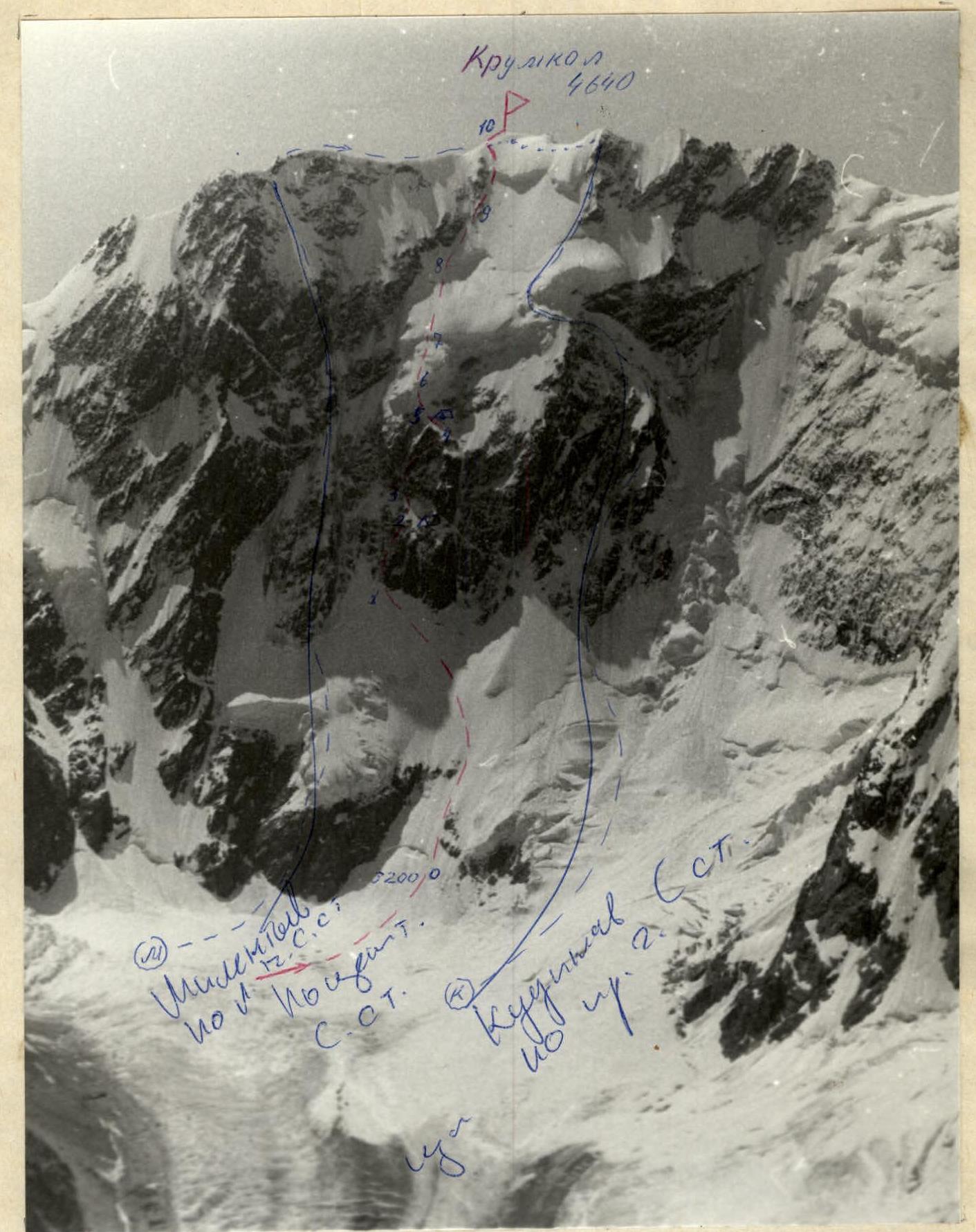
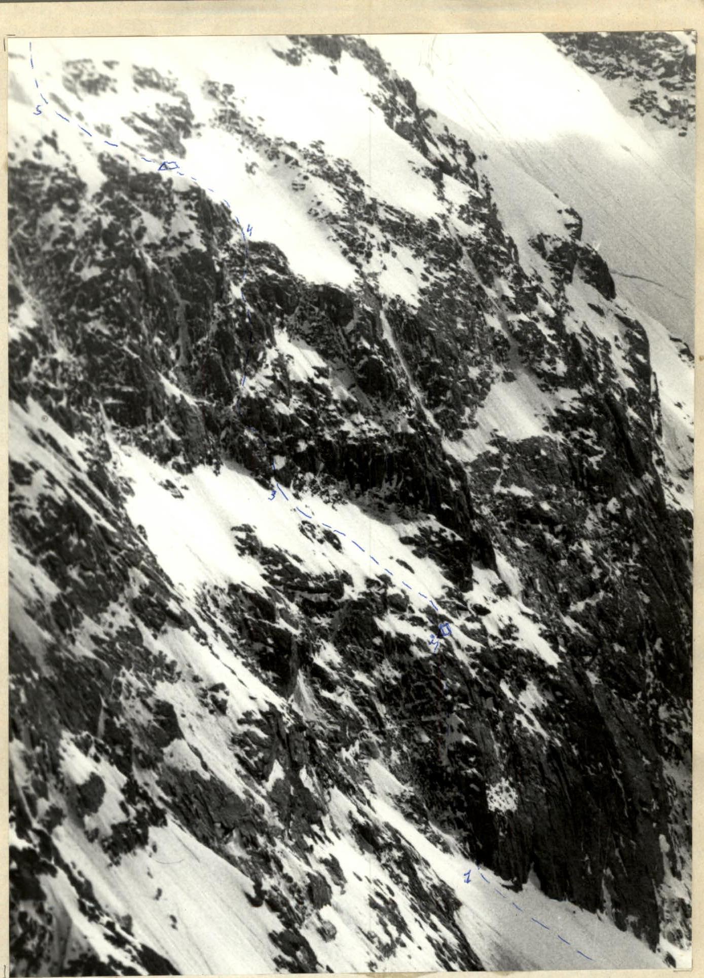
Krumkol wall. Melentyev's, Kudinov's routes, and the route through the Central Bastion are shown. Photo by V. Makarov on July 4, 1984, around 11:00. Lens I-61, F = 52.4 mm, distance about 4.5 km, height of the shooting point 4100 m.
Route diagram on peak Krumkol via the Central Bastion of the North face.
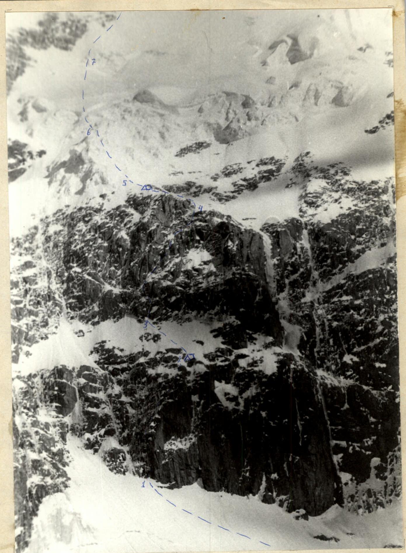
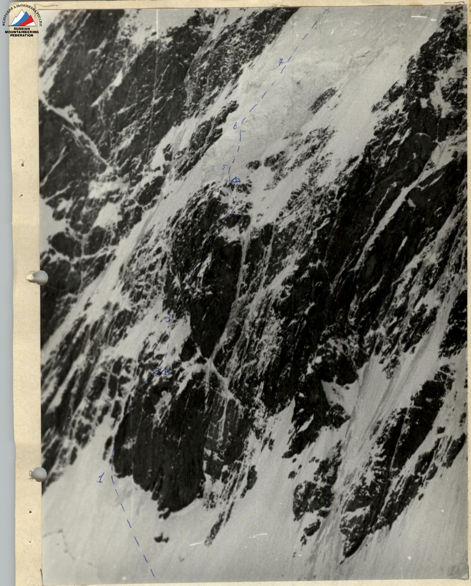
Central Bastion of the North face of Krumkol. View from "Krumkol bivouacs". Photo by V. Makarov on July 7, 1986, 17–18°. Lens Jupiter-37A with converter K-1, total f = 270 mm.

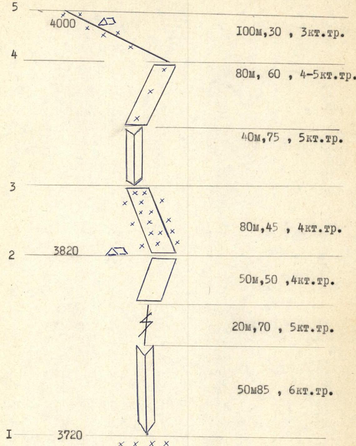
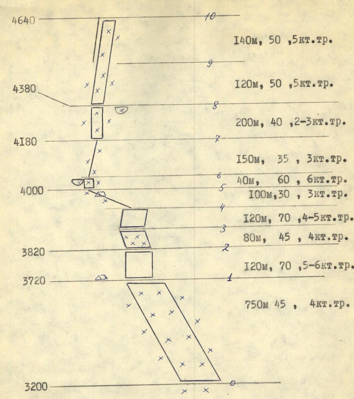
Detailed diagram of route sections on the Central Bastion of the North face of Krumkol.
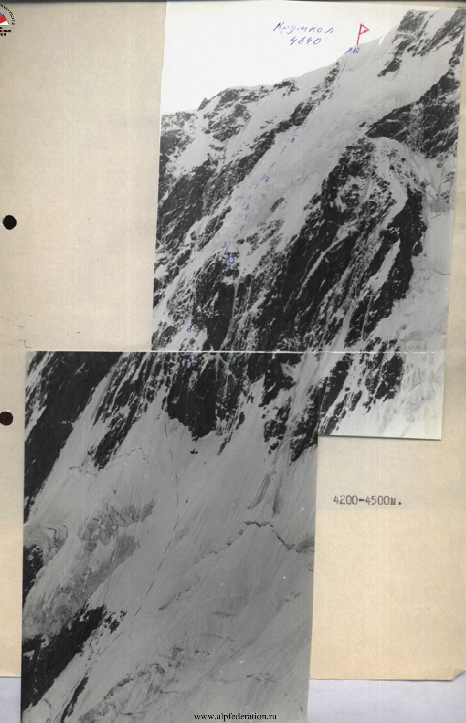
Central Bastion of the North face of Krumkol. View from the right. Photo by V. Makarov, 1982.
Central Bastion of the North face of Krumkol. View from the left, from bivouacs at 3900. Photo by V. Makarov, 1986.
Route description on peak Krumkol via the Central Bastion of the North face
The route goes "dirittissimo" to the summit between Melentyev's and Kudinov's routes.
Approach to the route from Krumkol bivouacs (3150 m) takes 0.5 hours. From the bergschrund (3200 m) along the ice slope along the rock island (section R0–R1, 750 m, 45°, 4) and further to the left, crossing the avalanche gully, to the central bastion of the north face. The lower wall of the bastion (section R1–R2, 120 m) is on the left part, starting almost next to the couloir that separates the route from Melentyev's route. The couloir is DANGEROUS! The wall is initially very complex, then becomes simpler (50 m, 85°, 6). The rocks are icy, movement is up the inner corner, then 40 m up the crevice to the right, 70°, 5, and further towards the spall against the sky along the slabs 50 m, 50°, 4 to the right and up. At the end of the section, there is a relatively comfortable place for a bivouac (3820 m). Further along the ice slope (section R2–R3, 80 m, 4) bypassing the rock islands to the left, up to the right, to the second rock wall. The second wall (section R3–R4) is traversed along the ice-filled inner corner 40 m, 5, and further to the right and up along the ice ledges (80 m, 4–5) to the exit to the ridge. Along the rocky-snowy ridge to the left (section R4–R5: 30°, 3).
Beyond the ridge, there is a large funnel where ice falls from the ice barrier and goes into the couloir to the right of the central bastion. On the ridge, there is a relatively good bivouac (4000 m).
Further exit along the ice wall (section R5–R6, 60°, 6) to the ice ridge (section R6–R7, 3). The ridge consists of horizontal snow-ice bridges and walls. The walls are bypassed to the left. The ridge leads to a snow-ice slope (section R7–R8, 200 m, 40°, 2–3). Movement along the slope is up towards the ice overhang above the bergschrund. (A sheltered bivouac is possible at 4380 m). The first ascendants bypassed the overhang to the left due to the avalanche danger of freshly fallen snow under the overhang. However, when bypassing to the left, it is necessary to cross the ice slope on the section R8–R9, where cornice falls from the main ridge of Krumkol are possible. When passing to the right, nothing hangs over the route.
After the bergschrund, along the ice slope (120 m, 50°, 5) in the direction of the rightmost rocks and further along the ice, bypassing the rocky ridge to the right (section R9–R10, 140 m, 50°, 5) to the summit. The ice on sections R8–R9–R10 constantly changes structure and density. Section R9–R10 can be traversed along the rocky ridge. The summit at 4640 m is a snow-ice pyramid. The cairn is 20 m below the summit on a ledge. A bivouac is possible near the cairn.
Descent
- Along the South ridge, category 3B, and further through the passes to the Bezengi base;
- Along the East ridge into the Krumkol hollow and further through "3900" to the base.
Objectively dangerous places:
- Crossing the avalanche gully, which exits to the right from behind the central bastion on section R0–R1. Must be traversed only at night.
- The lower part of the ice wall (section R5–R6), above which ice blocks hang.
To the left, the entire route is separated from Melentyev's route by a rock- and avalanche-dangerous couloir.
The heights of the points are determined by an altimeter during unstable weather, so they may differ slightly from the actual ones.