Passport
- Ice climbing category
- Central Caucasus, Bezengi valley
- Peak Krumkol 4676 m, via North-West Face
- Estimated category: 5B, first ascent
- Route characteristics:
- elevation gain — 1500 m
- length — 2450 m
- sections with 5–6 category complexity — 1020 m
- average steepness — 50°
- Piton usage:
- ice screws — 110
- rock pitons — 4
- Climbing hours — 36, days — 4
- Overnight stays: in a tent, comfortable
- Team leader: Vladimir Ivanovich Dotsenko, Candidate Master of Sports Team members: Viktor Nikolaevich Dubina, 1st sports category Aleksandr Vladimirovich Pashkin, Candidate Master of Sports
- Coach: Ivan Georgievich Kolotilo, Candidate Master of Sports Senior coach: Yuri Sergeevich Saratov, Master of Sports
- Approach to the route: August 17, 1997 Summit: August 20, 1997 Return: August 22, 1997
- Routes previously climbed on Krumkol peak (4676 m):
- (5–6 category complexity)
- via NE wall along N ridge R. Andreev, 1960
- via NW wall along N ridge G. Chunovkin, 1964
- via N ridge A. Timofeev, 1967
- via left part of N wall V. Melentyev, 1982
- via right part of N wall I. Kudinov, 1971, var. L. Volkov, 1988, A. Grigoretsiv, 1988
- via center of N wall A. Kolchin, 1986
- The route via NW wall is a first ascent.
Tactical Actions of the Team
The tactical plan for the ascent was based on a good knowledge of the area and the current state of the route. Special attention was given to ensuring safety measures. The team planned to complete the route with two overnight stays during the ascent and at the summit, and thus started the route from the "Krumkol" overnight bivouac at 02:00 on August 17, 1997. By 13:00, the weather suddenly deteriorated. Snowfall, wind, visibility 5–7 m. Movement became impossible. At 14:00, they stopped for an overnight stay in a safe bergschrund. They set up a tent.
On the second day, due to bad weather, they started the route at 09:30. Because of worsening weather, they stopped moving at 15:00 and set up a tent in a convenient ice cave. On the third day, the snowfall stopped. Visibility was 20–30 m. They started the route at 08:00. After crossing the bergschrund, they ascended a snow-ice slope between rocky outcrops and reached a steep ice slope with flowed ice, leading to the ridge. They reached the ridge at 18:30. There was a strong, gusty wind. They spent the night on the ridge in a tent. On August 20, 1997, they started the route at 07:00. The weather remained unchanged. They ascended along the rocky ridge, bypassing the first gendarme on the right, then through the second gendarme with piton belay, and further along a snow-ice gully to reach the pre-summit slope. They reached the summit at 15:10. There was thick fog.
The descent from the summit was done by heading south via a 3B category complexity route, down to the Krumkol glacier and through the Sptyak and Kamnepadny passes. The team returned safely to the Bezengi Alpine Ski Base on August 22, 1997.
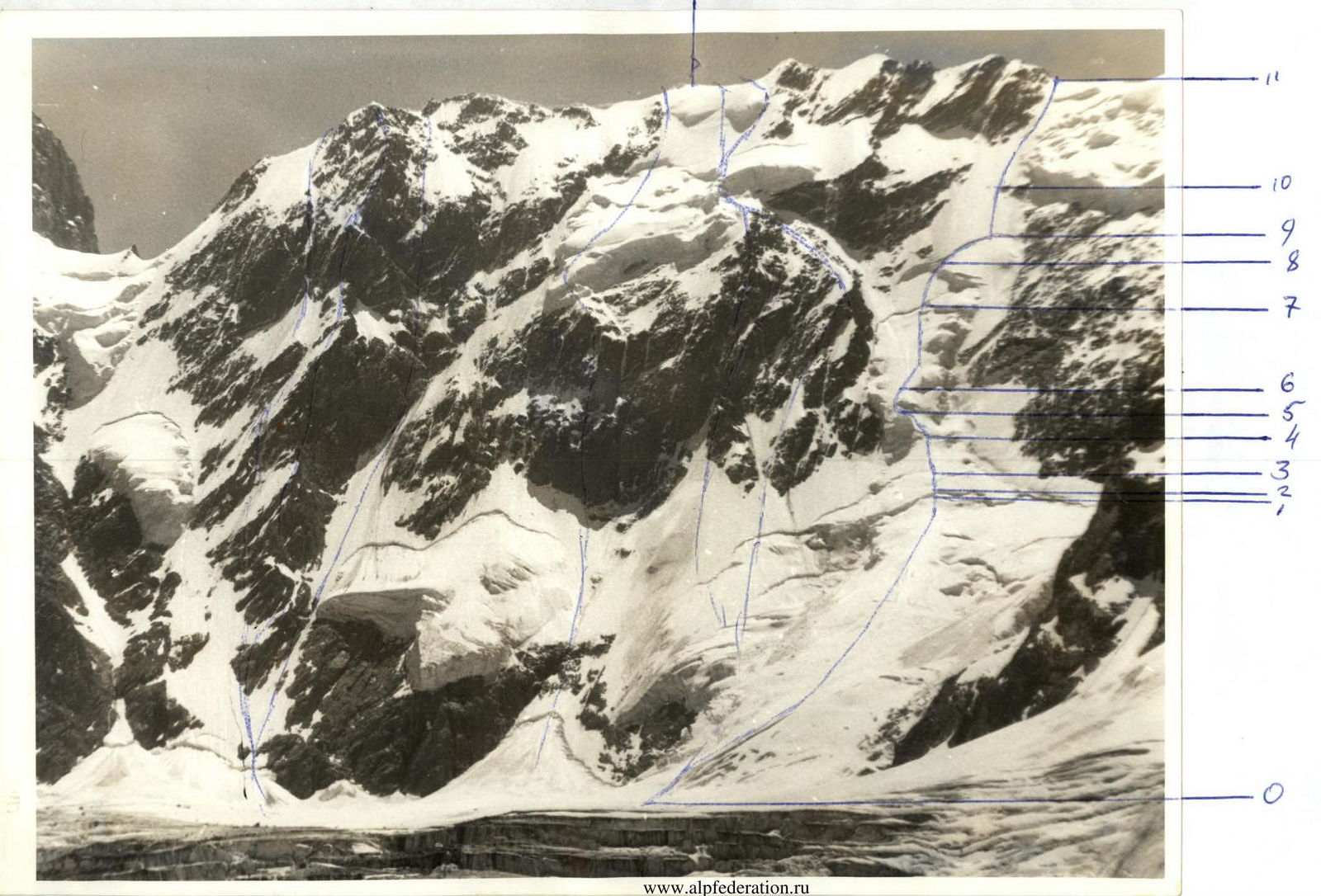
Route Description by Sections
| Section | Steepness | Length | Description |
|---|---|---|---|
| R0–R1 | 25°–30° | 500–600 m | Ascend the avalanche cone to reach below the bergschrund, leaving the gullies on the right. |
| R1–R2 | 90° | 5 m | Cross a complex bergschrund wall. |
| R2–R3 | 30° | 20 m | Snow slope with a crust, beneath which is powdery snow. Snow in the gullies does not give way. |
| R3–R4 | 80° | 60 m | Steep ice slope. Ice screws do not screw in well. |
| R4–R5 | 50° | 180 m | Snow-ice slope. Sections with a thin layer of ice (5–10 cm) are encountered. |
| R5–R6 | 60° | 80 m | Ice section. Move directly upwards towards the base of a vertical ice wall, bypassing it on the right through gullies. |
| R6–R7 | 45° | 200 m | Ascend a snow-ice slope to the right and upwards to reach below the bergschrund. Sections with a thin layer of ice (10–15 cm) are encountered. Bad weather — overnight stay. |
| R7–R8 | 60° | 180 m | Firn-ice slope. Ascend to the next bergschrund. It is necessary to dig pits to reach the ice. Further — |
| R8–R9 | 20° | 140 m | Traverse along the lower edge of the bergschrund to cross it. Belay via ice screws on the bergschrund wall. Weather deterioration. Overnight stay. Cross the bergschrund. |
| R9–R10 | 50° | 160 m | Ascend an ice slope upwards, exit between rocky outcrops and then — |
| R10–R11 | 45°–55° | 420 m | Ascend a snow-ice slope leading to a ridge with significant flowed ice. Overnight stay on the ridge. |
R11–R12: Ascend along the rocky ridge, bypass the first gendarme on the right, then through the second gendarme, descend from it via sport climbing along the ridge and slope, and exit to the summit. From the overnight stays — 6 hours. Descend from the summit along the South Ridge, category 3B complexity.