Ascent of Koshtan-Tau via the Southeast Ridge with descent along the North Ridge
Accomplished by the MGS DSO "Trud" team under the leadership of MS USSR A. Naumov.

Tikhonov Peak
Koshtan-Tau from the south (from the Spartak Pass)
Brief geographical description and sporting characteristics of the ascent object
The Koshtan-Tau massif, with a height of 5151 m, is located in the northern spur of the central part of the Main Caucasian Range, and together with the peaks:
- Dykh-Tau,
- Mizhirgi,
- Krumkol,
- Ullu-Auz-Bashi
forms the northern cirque of the Bezengi valley.
The Koshtan-Tau massif closes the upper reaches of four valleys.
- To the north lies the Mizhirgi valley.
- To the east - the Dumala river valley.
- To the southeast - the Tyutyun-Su gorge.
- To the south - the valley with the Krumkol glacier, which is a lateral northern valley of the Dykh-Su valley.
To the north and northwest, the peak drops steeply to the Kundryum-Mizhirgi glacier with heavily snow-covered northern and northwestern walls. To the east, it drops to the Ullu-Auz glacier with a snow-covered eastern wall featuring huge hanging seracs, and a black rocky triangle is located in the lower right part of the wall. To the southeast, from the junction of the eastern and southern ridges, a steep snow-ice slope descends to the Tyutyun-Su glacier. To the south, the massif drops with a rocky wall, snow-covered at the top. To the left of the wall, a hanging glacier descends from the massif, and to the right - an ice slope ending in ice seracs.
From the peak, the north ridge extends north to the Kundryum-Mizhirgi Pass, featuring the Kundryum-Mizhirgi (4500 m) peak and the Skalny peak. To the east, the east ridge extends to the Ullu-Auz Pass, transitioning into the Koshtan-Krest ridge with peaks:
- Tyutyun-Bashi,
- Trud Peak,
- XXII Congress of the CPSU Peak,
- Mir Peak,
- Pioneer Peak,
- Oktyabrenok Peak,
- 3925 m.
To the south, from the first "gendarme" of the east ridge, the south ridge extends with peaks:
- Nameless (4100 m),
- Tyutyun-Tau,
- Nameless,
- Kol-Kaya.
To the west, the massif ends with Tikhonov Peak, from which the east ridge of Krumkol peak begins, starting at the Krumkol depression.
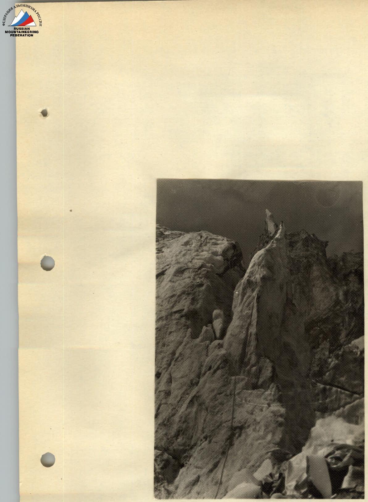
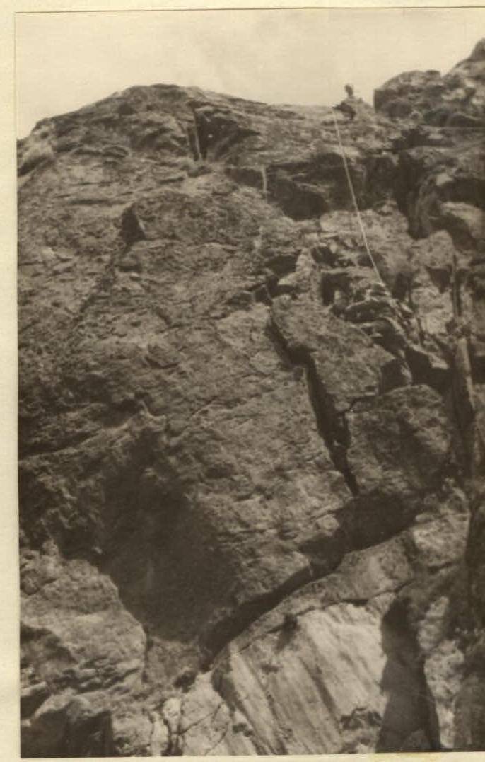
The southern wall of Koshtan-Tau is an elongated rocky triangle cut by a snow-ice couloir in its central part, interrupted by a rocky wall at the top.
The overall height of the wall from the base to the peak is 1300 m. The right edge of the triangle can be divided into four parts in terms of sporting difficulty:
- The first part - a snow-firn slope with a bergschrund. The total height is 130 m, with an average steepness of 35°.
- The second part - the lower part from the upper cirque of the Krumkol glacier to the height of the hanging ice seracs to the right of the edge (to the wall under the first bivouac) - is the most gentle rocky part. It is heavily damaged, with several rocky ascents, and is objectively hazardous due to rockfall from the wall and the left couloir as the sun rises; there is also a possibility of ice falling from the hanging seracs to the right. The total height is about 450 m, with a steepness of 35-40°.
- The third part - the middle section from the wall under the first bivouac to the second snow 40-45 m ridge above the first wall above the second bivouac. It is a purely rocky, technically challenging part of the wall. It is a steep edge, dropping off to the left with a sheer wall, and to the right cut by several narrow, snow-covered, and ice-filled couloirs perpendicular to the edge, constantly swept by rockfall. The total height is 300-350 m, with a steepness of 65-75°.
- The fourth part - the upper section to the peak - is a combined part of the route. This part of the wall consists of technically challenging, moderately difficult, and simple rocky sections alternating with ice-snow slopes and couloirs, mostly steep. The total height to the peak is 350-380 m, with a steepness of 45-50°.
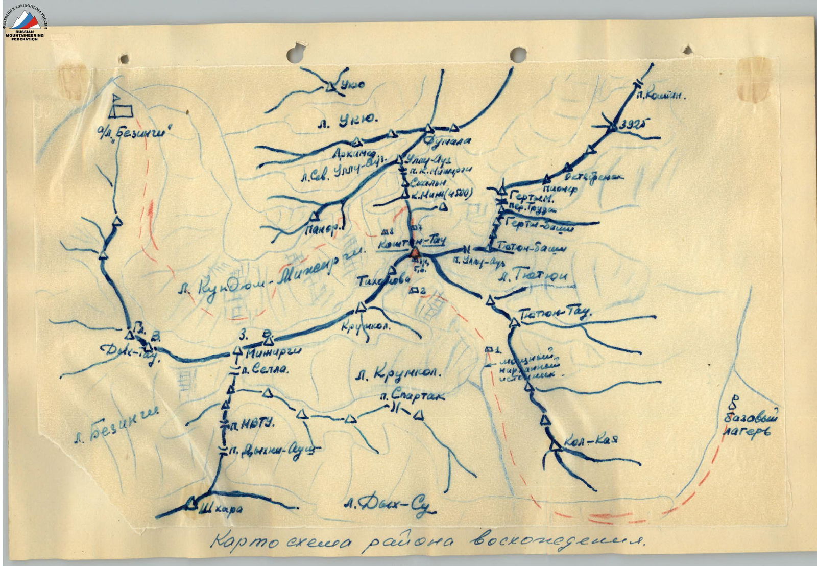
Map-scheme of the ascent area.
Ascent description
From the base camp located at the fork of the Dykh-Su and Karasu valleys, the path follows a faint trail along the left bank of the Dykh-Su River. From the base camp to the green meadow with bushes and springs under the tongue of the Dykh-Koto-Bugoy-Su (Dykh-Su) glacier - 3.5-4 hours' walk.
From the meadow, the path goes along the moraine to the left of the Dykh-Su glacier. After 500-600 m - a transition from the coastal moraine to the glacier and up the valley along its central moraine to the point where the Aylama glacier flows into it.
From the confluence of the glaciers - a transition to the right side of the Dykh-Su glacier and up along its right side, 150-200 m from the right moraine, to the first right lateral valley - the Krumkol valley.
The Krumkol glacier, which merged with the Dykh-Su glacier in the 1940s, has retreated up the valley by several kilometers.
The descent into the Krumkol valley from the Dykh-Su glacier follows the right moraine of the Dykh-Su and Krumkol valleys. Further ascent up the valley follows the right side of the Krumkol River towards the waterfall. The canyon with a 15 m waterfall is bypassed on the right along the "sheep's foreheads" 5-15 m from the river. Two small streams with weak narzan flow into the river along the "sheep's foreheads".
From the Dykh-Su glacier to the waterfall - about 30 minutes' walk. From the "sheep's foreheads", the further path follows the crater lake - along the moraine to good sandy sites under the southern slopes of Tyutyun-Tau, 30-40 m above strong and powerful narzan springs that have appeared under the retreated Krumkol glacier.
Here, on the sandy sites, the group stopped for the first night at 18:00.
On August 10, at 07:00, the group departed from the night's stop and, after 1.5 hours, ascended along the right moraine to the Krumkol glacier. Along the glacier, after 20-30 minutes, the group approached the icefall leading to the Krumkol depression and the southern walls of Koshtan-Tau, Tikhonov Peak, and Nameless Peak. The icefall, despite its short length, is complex. Its passage requires:
- Step cutting,
- Use of ice screws for belay,
- Installation of artificial anchors on two walls.
In the upper part of the icefall, the path goes left, bypassing a large number of deep crevasses.
The first four members of the group passed the icefall in 5 hours along its right side, 35-80 m to the left of the rocky walls of Nameless Peak. Here, in the center of a small plateau on a "peninsula" between crevasses, the group set up their second bivouac.
In the second half of the day, the group conducted observations of the locations and directions of rockfall and refined the previously chosen ascent route along the right edge of the triangle of the southern wall of Koshtan-Tau. Rocks fall from almost all the southern walls of Krumkol, Tikhonov Peak, and Koshtan-Tau, making the nearest approach to the wall during the day objectively hazardous.
Note: the time taken to pass individual sections of the route and the working day are indicated according to the first four members of the group.
On August 11, the group departed from the bivouac onto the main route. By bypassing crevasses, they began their ascent along gentle snow slopes towards the bergschrund under the base of the right edge of the triangle of the southern wall.
The bergschrund is passed along a 3-3.5 m ice-firn wall using:
- Two ice screws,
- Step cutting.
From the bergschrund, the ascent follows a 35-40° firn slope straight up, exiting after 40 m onto the rocks of the edge. Along gentle, simple, heavily damaged rocks of the edge, the path goes straight up for about 2.5-3 ropes to the first rocky ascent.
The 35-40 m ascent is overcome directly with cross belay along rocks of moderate difficulty.
Further, again along simple, heavily damaged rocks, upwards for 45-50 m towards the internal angle of the second 45-50 m rocky ascent of the edge. The first key location.
The first 2.5 m of ascent go along the right side of the angle. Then a 3-meter pendulum move using a hook into the angle. The next 10 m of ascent along the angle to a ledge - difficult climbing (2 hooks).
Further along a narrow ledge - a traverse along the left side of the angle into a narrow chimney-couloir. Up the chimney for 25-30 m (2 hooks) at the top. From the chimney, exit to the right onto the left wall of the angle and along rocks like "sheep's foreheads" after 3-4 m - exit to the second ascent (1 hook).
From the ascent along heavily damaged simple rocks under the next 5-6 m wall, which was passed along a crack directly. Further again along simple damaged rocks onto a ledge under the next wall. From the ledge through a 1.5 m wall - exit to the left side of the wall of the edge. The ascent along the wall goes simultaneously with a traverse to the left along slab-like smoothed rocks. The first pair passed the entire wall without backpacks.
Along rocks swept by rockfall, alternating with small 1.5-2.5 m walls to a ledge under an internal angle (2 hooks). Along the angle upwards for about 10-12 m to a transition of the angle into a vertical loose chimney (1 hook).
From under the chimney, a 2.5-3 m difficult traverse to the left (2 hooks for handholds). Then along the wall 5-7 m up to the left (1 hook) when exiting the wall onto an inclined slab. There are many "live rocks" on the wall. Along the slab, exit to the right onto a site.
Further ascent towards a ledge goes first along a 3-meter inclined 45° slab, then about 8-10 m along a vertical wall with good handholds but many "live rocks" (1 hook under the wall).
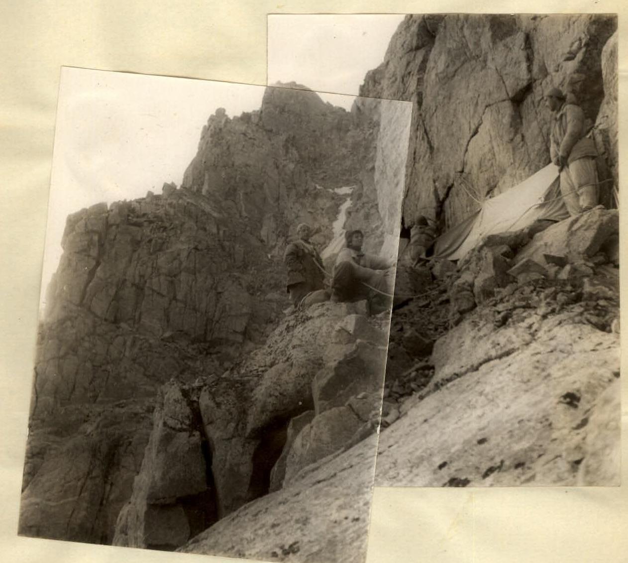
On the ledge at 16:00, the group stopped for the first sitting bivouac. A first control tour was left at the bivouac site. The group departed from the bivouac at 05:00. Traversing along the wall of the edge to the left, then 7-8 m along an inclined 45-50° slab with an exit onto a small 10-12 m, but steep 50-55° ice slope. The slope was passed with step cutting to a rocky outcrop.
Along the outcrop 4-5 m up under a rocky, ice-filled couloir. Along smoothed rocks with few handholds in the couloir, in two places turning into a wide angle, upwards for about 25-30 m (3 rock and 1 ice hook). There are many "live rocks" in the couloir. From the couloir, exit onto a ledge under a wall. Along the ledge, traverse under the wall to the left under the internal angle of the wall with two wide vertical cracks.
The ascent along the wall goes first along the right crack (1 hook) with an exit after 6-7 m from under an overhanging plug to the left.
1st bivouac on the wall (on the left in plan - rocks of the left edge of the south wall).
Onto a small ledge (2 hooks), further up 10-12 m along the left crack (2 hooks) with an exit from it onto the shoulder of a small counterfort extending to the left, perpendicular to the main edge.
From the shoulder, the path goes to the right of the counterfort's ridge and to the left of a narrow vertical couloir. The ascent to the main edge for about 50 m goes with careful hook belay (4 hooks) along 40-45° smooth slabs with few handholds, alternating with small vertical walls. From the slabs, exit onto a site on the edge.
From the site, the ascent goes straight up 20-25 m along rocks of moderate difficulty, under the next wall of the edge.
The second key location, passed first in gym shoes. The ascent onto the wall begins from the outer angle along a groove extending upwards to the right, using shoulders and then three hooks as artificial anchors, to a stone overhanging the groove. Under the stone along the wall 1.5-2 m - a very difficult traverse to the right (1 hook) along a smooth, almost vertical wall with no footholds and very small inclined handholds.
Further along the wall, traverse about 8-10 m to the right to a small groove extending upwards (2 hooks). Along the groove upwards 5-6 m (1 hook) with an exit from it to the right onto a "ledge". Along the "ledge", on which gym shoes barely hold and handholds are absent, traverse to the right about 6-8 m to a protruding "live" stone (2 hooks at the beginning and end of the ledge).
Through the stone - entry into the first chimney, ascent up which is blocked by an overhanging plug made of "live" stones at the top (2 hooks in the chimney).
On the route
From the chimney, a 3-3.5 m pendulum traverse to the right through the angle into the second vertical chimney (1 hook). Up the chimney for about 5-6 m with an exit through an overhanging cornice onto the shoulder of the next counterfort of the edge.
All group members passed this wall without backpacks, which were pulled up along the wall to the counterfort.
From the shoulder - traverse along a ledge and slabs to the right 15-18 m. Further upwards along rocks of moderate difficulty 20-25 m under a wall leading onto the ridge of the main edge.
The third key location, passed first in gym shoes. The ascent onto the ascent from the ledge goes along the central part of the 80-85° wall. The first 8-9 m are passed using shoulders and a ladder (5 hooks). Further up along a 60-65° slab 15-17 m (2 hooks) under an internal angle and along it, on jamming, upwards another 12-15 m (1 hook) with an exit onto a ledge.
On the ledge, a 2nd control tour was left. From the ledge - traverse under the wall along an inclined 40-45° slab 7-8 m to the right to a crack. Up the crack to the right (1 hook).
Further about 10 m of ascent go along rocks of moderate difficulty to the second ascent of the black wall. Along the ascent, representing 45-50° slabs alternating with small vertical walls, 30-35 m upwards (3 hooks).
The beginning of the fourth key location. From here, the path goes by traversing to the right 4.5-5 m along an inclined 50-55° slab, then overcoming an overhanging stone using two hooks as handholds. Further 10-12 m of difficult traverse to the right to a narrow 2-2.5 m crack-couloir. Rocks fall along the crack! Transition to a small ledge on the other side of the crack - by pendulum (2 hooks before and after the couloir).
Further about 20 m of complex traverse along a smooth, in two places overhanging wall, with few footholds and handholds (3 hooks). The next 25-30 m of traverse go along simple ledges with a small gain in height to a vertical crack. Up the crack 10-12 m with an exit onto the shoulder of the next counterfort.
The backpacks of the group members were pulled up to the counterfort along a hanging wall on the left.
From the shoulder, along simple damaged rocks of the counterfort's ridge, upwards for about 60 m to a small 6-8 m snowpatch lying on a horizontal ridge of the main edge.
At the snowpatch, at 19:00, the group set up their second semi-reclining bivouac on the wall. The third control tour.
The group departed from the bivouac at 06:00. The path follows a 45-50 m sharp horizontal rocky ridge with small snow sections, to the wall of the edge.
From under the wall (1 hook) - a 40 m sports descent along a slab onto a snow-covered ledge. From the ledge straight up 18-20 m along difficult, smooth rocks with few handholds under an overhanging slab (3 hooks). Under the slab, a complex 2.5-3 m traverse to the left (1 hook) with an exit onto a ledge. From the ledge, ascent along rocks of moderate difficulty with simultaneous traverse to the left onto the main edge.
Along the edge, after 25-30 m - exit onto a sharp 40-45 m snow ridge. From the ridge, the ascent goes along a 40-45° snow-ice slope under a heavily damaged rocky wall.
Under the wall (1 hook), on crampons, upwards along the boundary of ice and rocks for about 40 m - bypassing it on the right and exit to a steep 50-60° wide snow couloir (1 hook). By bypassing a "sheep's forehead" on the right, ascent under the wall for 8-10 m along the edge of the ice. Exit from the couloir to the left onto rocks (1 hook) under cover of walls. Rocks fall along the couloir!
Further straight up, first along rocks of moderate difficulty and slabs for 25-30 m. From the rocks, on the front teeth of crampons, 10-12 m along a 50-55° ice slope under a rocky ascent.
Under the ascent (1 hook) - a 5-6 m traverse along the ice to the left under a couloir. Up the couloir:
- First 10 m along its right wall (1 hook);
- Further, the couloir narrows and turns into a narrow, with smooth walls filled with ice, vertical 15-20 m chimney (2 hooks), up which the ascent and exit to the right onto an inclined slab.
At this section, due to the narrow chimney, it was necessary to pull up the backpacks of all group members.
Further ascent goes along a gentle snow-covered slope:
- First along simple damaged rocks,
- Then along rocks of moderate difficulty,
- Under an overhanging bright orange-red wall of a tower.
Rocks may pass along this slope. The tower is bypassed on the right under the wall, along the boundary of ice of a steep 45-50° ice couloir (3 ice hooks). After 60-70 m, at the point of narrowing of the couloir, along rocks protruding from the ice - transition across the couloir (1 hook) to its right side and up its 6-7 m rocky wall (1 hook) - ascent onto a small counterfort. Further along rocks of moderate difficulty upwards, first along the counterfort, which after 16-20 m turns into a 45-50° rocky, heavily snow-covered slope.
There are many "live rocks" on the slope. The rocky slope after 45-50 m turns into a steep, passed on crampons, ice slope 50 m. Up the slope under an overhanging wall. The last 7-8 m before the wall, the slope sharply increases its steepness, and it is necessary to cut steps (2 ice hooks).
Under the wall (1 hook), along the edge of the ice, traverse to the right into a very narrow couloir. Rocks fall along the couloir!
The couloir is crossed to the right, not entering it, with an ascent along an 8-10 m wall on its right side. From the wall (1 hook) onto a small counterfort. Transition to the right side of the counterfort and up its right side under a snow-covered wall.
Under the wall, traverse to the right 6-8 m and further up onto a snow-covered ledge. At 18:30, 10-12 m to the left of the exit point onto the ledge, the group set up their third semi-sitting bivouac, just below a huge overhanging rock.
On August 14, 1953, dark thunderstorm clouds appeared in the south beyond the Bezengi wall in the morning. At 05:00-06:00, the first four members of the group departed onto the route.
From the bivouac site:
- Along the boundary of the snow slope - traverse under the wall to the right to a clearly visible slope-angle (1 hook);
- Up a crack 2 m;
- Difficult exit to the right;
- Further traverse to the right for about 10-15 m (1 hook) with a gain in height to the outer angle of the wall.
Handholds are good but scarce.
From the angle, descent (1 hook) behind the angle down to the left for 3-4 m. Further ascent goes along the left wall to the right upwards: first along a small angle, then along a narrow 8-10 m crack. Handholds are absent, and the ascent along the angle and crack is carried out on jamming (1 hook). From the outer angle upwards along the crack, it was necessary to pull up the backpacks of all group members.
Further up along rocks of moderate difficulty - exit onto the ridge of the counterfort and up it under the next wall.
To the left of the counterfort, vertical walls drop off into a narrow ice couloir, along which stones often fly.
From under the wall, ascent upwards to the right along a vaguely expressed 70-75° rocky couloir, using a ladder, for 8-9 m (3 hooks). Further 15-20 m straight up along the wall - difficult climbing, handholds and cracks are practically absent (2 hooks) with an exit onto a 2-meter smooth slab (1 hook).
Above the slab, an enormous stone overhangs, which is bypassed on the right. Behind the stone 12-15 m up to the left under an overhanging wall. From under the wall - traverse through a couloir, which at this point represents a wide internal rocky, almost vertical, angle of the ascent.
The traverse is difficult (2 hooks at the beginning and end of the angle) because the rocks are heavily snow-covered and water flows along the angle, and stones flying from above pass over the wall.
From the couloir, first to the left, and then upwards to the right along rocks of moderate difficulty, along a vaguely expressed counterfort, to a small ledge under a 3-meter wall.
Here, 1.5 m below and to the right of the ledge, it is possible to collect water for drinking.
From the ledge, the path goes straight up through a 3-meter wall, using a ladder (1 hook). Further ascent goes along snow-covered rocks above moderate difficulty, to a ledge under the next wall. On this ledge, the group was first caught in fog. A strong wind blew from the south, initially weak, then strengthening. Further ascent proceeded in strong winds, occasionally with:
- Graupel falling,
- Dense fog.
From the ledge, the ascent path went to the right, bypassing the wall, with an exit onto a counterfort along heavily smoothed and damaged rocks of a couloir. Then along the ridge of the counterfort to the left upwards to an exit onto a sharp horizontal 60-70 m firm firn ridge extending from the southern wall to the north towards the peak.
Along the ridge, on crampons, the group exited with a slight loss of height onto a small southern plateau 50-60 m below the peak of Koshtan-Tau.
The weather deteriorated completely, a strong wind blew, snow fell, and visibility reduced to 3-5 m. The group set up a bivouac on the plateau at 16:30.
Throughout the night, snow fell, and a strong wind blew. On August 15, the wind did not subside, but the snow stopped, and the clouds partially cleared. At 11:00, through breaks in the clouds, the sun appeared. The group quickly packed up and reached the peak at 12:00. After 15 minutes, along a heavily snow-covered slope, overcoming a small bergschrund, and sticking to the rocks, the group reached the peak.
After changing the note in the cairn, the group began their descent along the north ridge of the peak, category 4A.