Report
on the first ascent of the route to the summit of Itkayabashi 3197 m.
via the left part of the center of the Western wall (proposed 6A category) by the team of Sumy region FAS from August 3 to 5, 2013.
Team captain: Roshko V. I.
Team coach: Mityukhin F. P.
Sumy — 2013
Addresses:
Coach Mityukhin Fyodor Petrovich, 40004, Sumy, Metallurgov str., 14/67; home phone: +38 (050) 634-34-34; work phone: 8 (0542) 61-99-64
Leader Roshko Vladimir Ivanovich 40024, Sumy, Prokofieva str., 31/1, apt. 6; phone: +38 (050) 965-76-37.
The height was determined using an altimeter; steepness was determined visually and using AutoCAD software.
Ascent Passport
-
Type of ascent — rock climbing.
-
Ascent area — Caucasus, Rocky Range, Bezengi area.
-
Summit Itkayabashi (3197 m) via the left part of the center of the Western wall.
-
Proposed — 6A category, first ascent.
-
Height difference of the route — 697 m.
Wall part — 520 m. Route length — 1245 m (including 85 m — traverses along ledges) wall part — 645 m (including 85 m — traverses along ledges). Length of sections: 6th category — 175 m (including 115 m ITO), 5th category — 275 m. Average steepness of the route — 64°, average steepness of the wall part — 76°.
- Pitons driven:
Rock 82, bolt 2, chocks 104.
-
Team's walking hours — 26 hours, 7 days
-
Overnights:
- 2 overnights on the wall — lying down
-
Leader: Roshko Vladimir Ivanovich — Master of Sports of International Class (MSMK)
Participants:
- Shimko Nikolay Nikolayevich — Candidate for Master of Sports (CMS)
- Mironchak Mikhail Vadimovich — 1st sports category
-
Mironchak Mikhail Vadimovich — 1st sports category
-
Exit to the route:
summit, return to Base Camp
August 1, 2013 at 9:00
- August 5, 2013 at 15:00
- August 5, 2013 at 17:30.
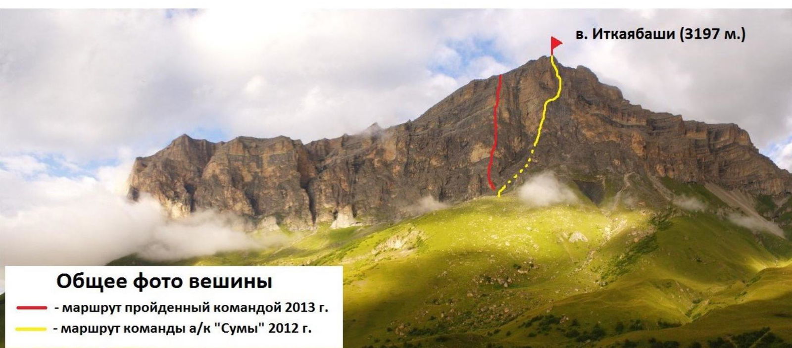
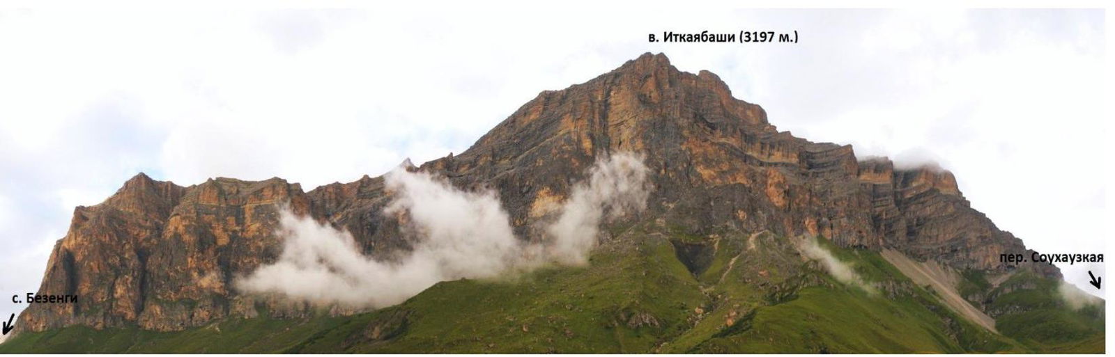
General photo of the summit
-
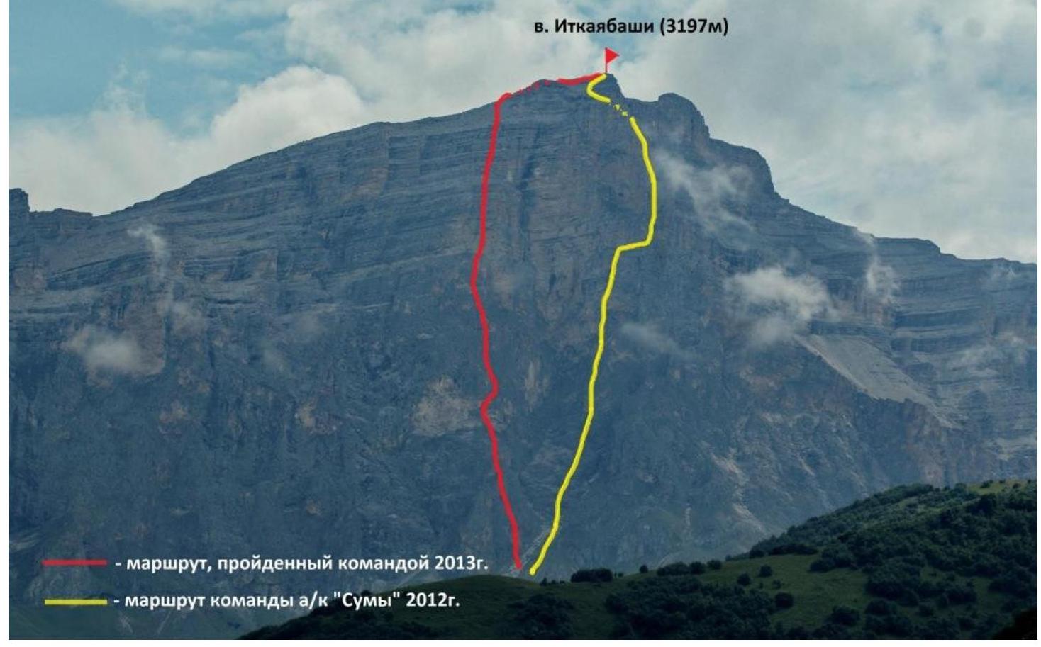
route climbed by the team in 2013
-
route of the team "(к «Субъ»» in 2012
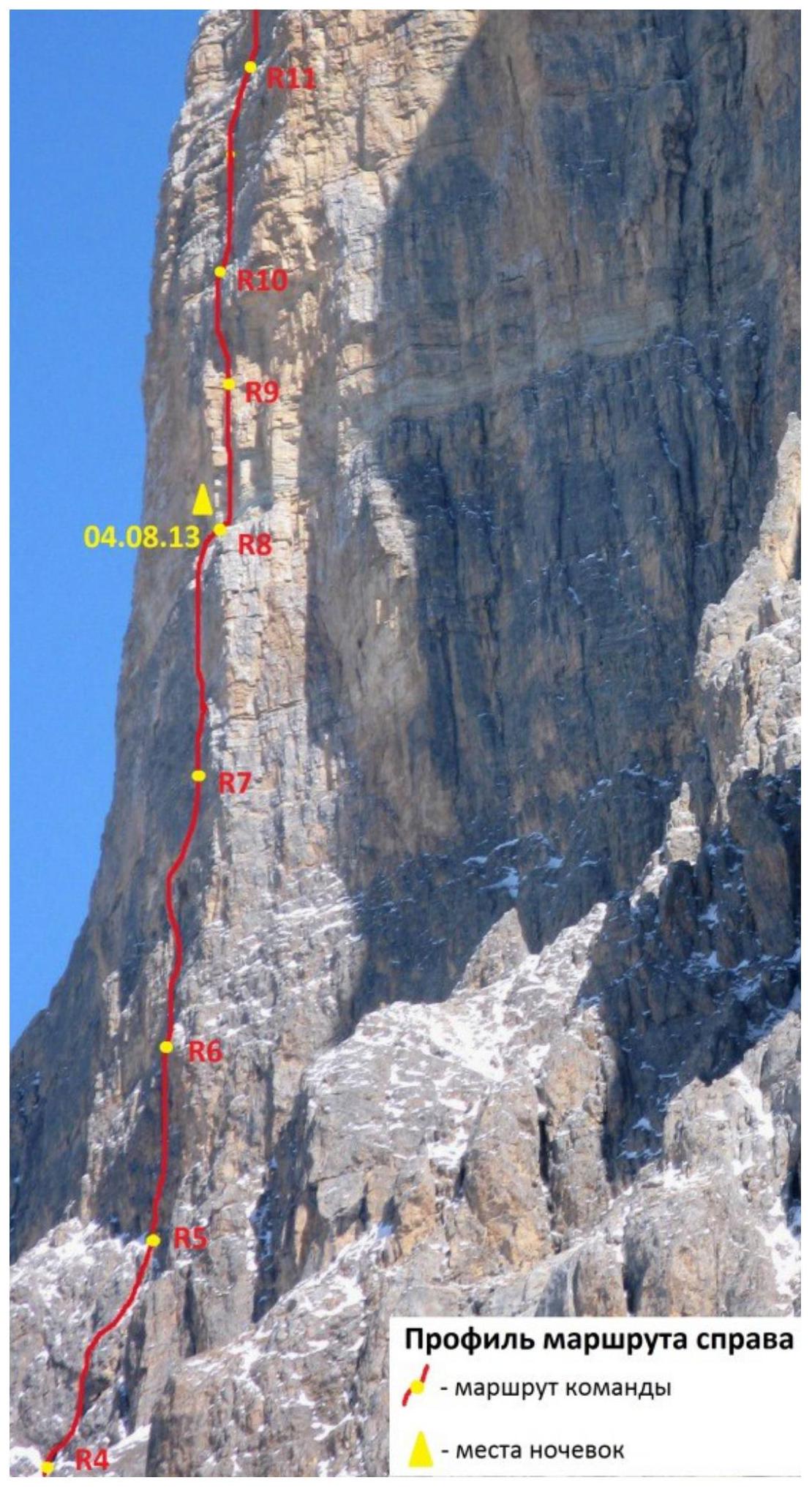
PROFILE OF THE WALL FROM THE RIGHT
Profile of the wall from the left
It was not possible to take a profile of the wall from the left. DRAWN PROFILE OF THE ROUTE
Topographic map of the area
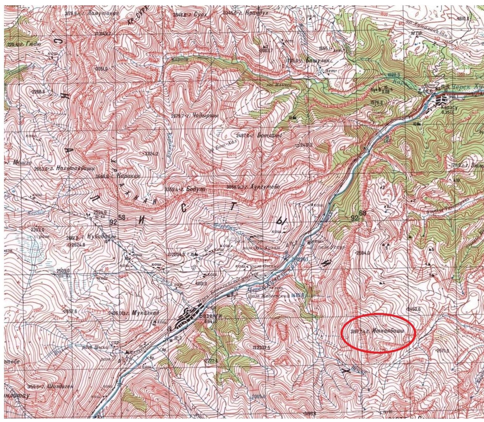
Photo panorama of the area
Brief overview of the ascent area
Brief overview of the ascent area
The Rocky Range is a cuesta (with a steep, abrupt southern slope and a gentle northern slope), dissected by numerous narrow valleys of the basins of the rivers:
- Kuban
- Terek
- Others
The valleys separate inclined plateaus to the N-N-E. Karst is developed.
© (Text from the Great Soviet Encyclopedia)
Alpinist exploration of the Rocky Range began relatively recently. In 1979, the USSR Championship was held here. All routes were laid decked on the summits:
- Ak-Kaya
- Kara-Kaya
Itkuyabashi (3197 m) is a summit of the Rocky Range. The massif has a northern and western exposure. The western walls are the most extensive. Despite a fairly large height difference (up to 800 m) and steepness of the walls, there was not a single route on it until 2012.
The walls are steep, with numerous overhangs, and have a "step-like" structure. The rocks are very destroyed. The upper bastions resemble a layered pie.
It should be remembered that the wall has a northern and western exposure, so it is quite cold in winter, but safe. There is no water on the wall in summer.
If the ascent requires several days, you will have to drag a decent water supply with you.
Descent from the summit must be made:
- Along the ridge to the south,
- Then down the gorge.
In summer, it does not present any difficulty, but in winter it can be avalanche-prone.
Technical photo of the route

Preparation for the ascent
The team of Sumy regional FAS included:
- Roshko V. I. — MSMK — team captain.
- Shimko N. N. — CMS
- Mironchak M. V. — 1st sports category
All participants had good technical and physical preparation, as well as experience on routes up to 6A category inclusive.
The object of the ascent — Mt. Itkayabashi — was determined long before the start of the trip.
In winter 2012, the team of the Sumy club made a first ascent via the center of the Western wall. During the ascent, the team paid attention to the left part of the wall and took photographs.
The final route was determined immediately before the ascent.
Material support for the team:
-
The team had a sufficient arsenal of rock climbing equipment.
-
Food — about 400 g per person per day.
-
Water — 30 l.
-
First-aid kit, completed by a doctor.
-
For communication, "MONTOROLA talkabout" radios were taken, 2 pcs. for communication between participants on the wall, and another 1 was at the observer below. During the ascent, Venslavovskiy Aleksandr Nikolayevich — rescue team leader, CMS — was the observer under the wall.
TACTICAL ACTIONS OF THE TEAM.
August 2, 2013. Delivery of the team under the Itkaya-Bashi massif. A camp was set up, necessary cargo (equipment, 30 l of water) was delivered under the wall, and the route was determined. After carefully examining the proposed route, it was decided not to carry out preliminary processing, but to start the ascent immediately.
August 3, 2013. At 9:00, the team started working on the route. Shimko N. worked first. The start of the route — "ram's foreheads". Dry rocks allow for relatively fast movement. By 18:00, they passed 200 m to a large ledge and hung 4 more ropes above. Overnight on the right part of the large ledge in a safe place under the yellow wall (safe place). From 14:00, dense fog, which condenses on the rocks. Sometimes it drizzles.
August 4, 2013. From 7:00, movement along the processed ropes. From 9:00 — work above. Mironchak M. worked first. By 15:00, they passed 3 difficult ropes to a ledge suitable for overnight stay. Managed to process another 35 m of difficult rocks through a cornice with ITO to A3. Weather was good all day, but it rained towards the evening. Storm warning at night.
August 5, 2013. From 8:00, work above the processed rope. Roshko V. worked first. Movement along "blocky" rocks. After passing 100 m of steep rocks, they reached a large talus ledge. Further movement upwards through steep rock steps, interrupted by ledges. At 15:00, the entire team was at the summit of Itkayabashi. Descent from the summit presented no technical difficulties. Movement:
- to the south, towards the pass under Mt. Soukhauzkaya
- further down the gorge.
There were no injuries or illnesses among the participants on the route.
Scheme in UIAA symbols
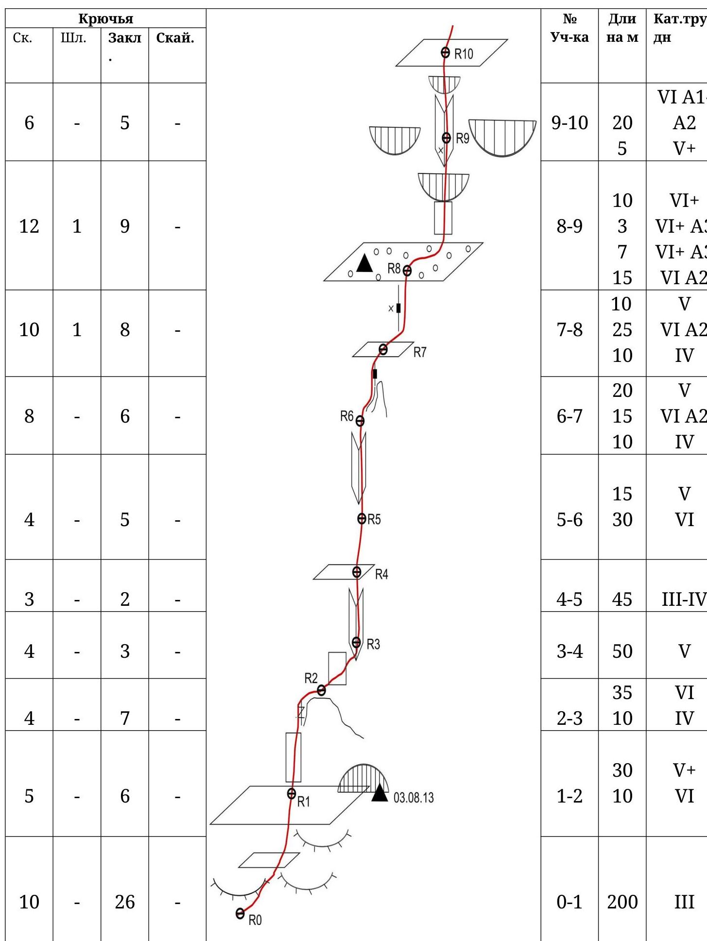
Scheme of the route in UIAA symbols (sheet 2)
| Pitons | | | | | Section # | Length m | Category | Steepness
B | | | :--: | :--: | :--: | :--: | :--: | :--: | :--: | :--: | | | Rock |
Bolt | Chocks | Rock. | | | | | | | - | - | - | - | | 16-17 | 300 |
no cat. | | | - | - | - | - | | 15-16 | 100 | no cat. | 40 | | 4 | - | 8 | - | | 14-15 |
70 | V A1 | 70 | | 4 | - | 3 | - | | 13-14 | $\begin{gathered} 30 \ 15 \ 5
\end{gathered}$ | $\begin{gathered} \text { no cat. } \ \text { V+A1 } \ \text {
no cat. } \end{gathered}$ | 80 | | - | - | - | 5 | | 12-13 | $\begin{gathered} 30 \
10 \ 20 \end{gathered}$ | $\begin{gathered} \text { no cat. } \ \text { IV } \
\text { no cat. } \end{gathered}$ | 60 | | 3 | - | 5 | - | | 11-12 |
$\begin{gathered} 10 \ 5 \ 15 \ 15 \end{gathered}$ | $\begin{gathered} \text
{ IV } \ \text { VI A1 } \ \text { V+ } \ \text { no cat. } \end{gathered}$ |
$\begin{gathered} 70 \ 90 \ 80 \end{gathered}$ | | 5 | - | 6 | - | | 10-11 |
40 | V+A1 | 70 | .
Description of the route by sections
R0–R1. The start of the route is in the lower part of the couloir, 70 m to the right of the large chimney. As expected during the ascent in winter 2012, the couloir is sometimes "swept" by stones in summer.
The first 50 m:
- Move along the "ram's foreheads"
- Move to the right
Further:
- Movement strictly upwards under the rusty wall
On the right part of the ledge:
- A convenient and safe place to spend the night in a niche
200 m, III, 45° (average steepness of the entire section).
R1–R2. From the ledge, move upwards 30 m along destroyed rock in the direction of the left gap of the large outcrop. Then 10 m of forceful climbing along the gap to the top of the outcrop. Then traverse to the right 5 m. Station.
- 30 m, V+, 70°
- 10 m, VI, 85°
- 5 m, V, 75°
R2–R3. Traverse to the right along unreliable terrain in the direction of the internal angle. Further upwards, move to the right internal angle. Station on a small ledge at the base of the internal angle.
- 35 m, VI, 80°
- 10 m, IV, 70°
R3–R4. Move upwards along the internal angle to a ledge. Station.
- 50 m, V, 75°
R4–R5. From the station upwards along simple rocks under the rusty wall.
- 45 m, III–IV, 60°
R5–R6. Upwards along the internal angle.
- 15 m, V, 70°
- 30 m, VI, 75°
R6–R7. From the station, first to the right, then upwards along destroyed steep rocks under the "feather". Further, to the left of the "feather" along a steep wall upwards under the overhanging wall with a gap. ITO along the gap (or 6b) 15 m and a small climb to a small ledge. Station is semi-hanging.
20 m, V, 75°; 15 m, VI, 95°, A2; 10 m, IV, 80°.
R7–R8. Along the wall and a system of small cracks, move towards a clearly visible gap. After 20 m, a piton is driven (a втулка is left). The gap is overhanging. On ITO to a small flattening. And further climbing to a large ledge under the white wall. Overnight is possible.
10 m, V, 75°; 25 m, VI, 95°, A2. 10 m, IV, 65°. R8–R9. Along the ledge 10 m to the right under the internal angle with a large cornice. From the ledge, a difficult climb under a thin gap. Further ITO under the cornice. After the cornice, the relief is richer —
- ITO
- climbs (6a)
20 m from the ledge, a piton is driven (a втулка is left). After 15 m, a station in the internal angle (a large cornice on the right).
10 m, VI+, 90°; 10 m, VI+, 90°–180°, A3; 15 m, VI, 80°, A2.
R9–R10.
Upwards along the destroyed internal angle with a wide gap in the upper part. Climbing through the overhang to a ledge. Station
20 m, VI, 90°, A1–A2; 5 m, V+, 90°.
R10–R11.
From the station upwards along steep "blocky" rocks, climbing, partly on ITO A1.
40 m, V+, 70°, A1. R11–R12.
Upwards under the destroyed gap. ITO along the gap. Further climbing through 30 m to a large talus ledge.
Many loose stones!!!
10 m, IV, 70°; 5 m, VI, 90°, A1; 15 m, V+, 80°; 15 m, no cat.
R12–R13. Along the ledge to the left, 30 m on foot. Find the easiest exit through a rock wall. Overcome the rock wall and reach a talus ledge. Along it, 20 m to the next rock step.
30 m, no cat.; 10 m, IV, 60°. 20 m, no cat.
R13–R14. Along the ledge to the right, 30 m. Then upwards, climbing:
- 10 m
- 5 m on ITO to the next ledge.
30 m, no cat., 15 m, V+, 80°, A1. 5 m, no cat. R14–R15. Upwards through 2 rock steps, alternating with small talus ledges, climbing, partly simple ITO. Reach the "roof" — a huge talus slope (many loose stones!!!). Station on a destroyed rock 15 m from the exit to the ledge.
70 m, V, 70°, partly A1. R15–R16. On foot to the ridge. 100 m, no cat., 40°; R16–R17. On the ridge, turn to the right and after 300 m reach the summit!!! 300 m, no cat.
Protocol
of the debriefing of the ascent made by the team of Sumy regional FAS and AC, club "Sumy" within the framework of the 2013 Ukraine Championship in rock climbing, on Mt. Itkayabashi via the left part of the center of the Western wall, 6A category, first ascent.
from August 3 to 5, 2013.
August 7, 2013.
Team composition:
- Roshko V. I. — MSMK, leader
- Shimko N. N. — CMS.
- Mironchak M. V. — 1st sports category
Debriefing is conducted by the senior coach, releasing UTS Sumy regional FAS — Master of Sports, Honored Trainer of Ukraine (ZTU) Mityukhin F. P.
Present at the debriefing:
- Venslavovskiy A. N., CMS — head of the rescue team.
Mityukhin F. P.
The team of the club "Sumy" made a first ascent on Mt. Itkayabashi via the left part of the center of the Western wall, proposed 6A category, within the framework of the Ukraine Championship in rock climbing. I ask the participants of the ascent to share their opinion on:
- technical difficulty of the route,
- its condition,
- tactics of the ascent,
- compliance with safety measures.
Mironchak M.V. The technical difficulty of the route is that a large part of it passes through unreliable rock relief. This complicates the organization of reliable belay points. On such a route, very good rock climbing preparation and technique are required.
Shimko N.N. As for the condition of the route, it should be noted that the relief is very unreliable. Many sections are climbed "on decisiveness". There is no water on the wall at all, so we had to carry almost 30 l of water with us.
Roshko V.I. The route is logical, technically complex. It has a fairly large height difference of the wall part. The team worked very cohesively. Due to the peculiarity of the relief, primary attention was paid to compliance with safety measures.
- The first climber almost always moved on a double rope.
- Under the route, our observer — the head of the rescue team — was watching us.
- Communication sessions took place strictly at the appointed time, without omissions.
That is, safety measures were maximally observed.
Conclusion of the senior coach Mityukhin F.P. The team climbed the route technically and tactically competently, without violating safety measures, and without deviating from the planned tactical plan. The height difference of the route, its length, average steepness, and the length of sections of 6th and 5th categories correspond to routes of 6A category. The first ascent of the route is credited to all team members, and the leadership is credited to the leader of the ascent. The report on the ascent should be submitted to the judging panel of the Ukraine Championship in rock climbing, and a copy of the report should be submitted to the Classification Commission of the FAS of Ukraine.
Senior coach, Master of Sports, ZTU Mityukhin F. P.