Dumala-Tau (4680) via South Ridge — Cat. 4B
From the bivouac behind the moraine, the path goes up the grassy slopes and talus, bypassing the ridge descending from the Dumala-Tau massif, to the right of the icefall.
The route along the South Ridge begins to the left of a slab with a crack and a small stream at its upper part, via an 80-meter snowy couloir upward to the right onto a destroyed saddle behind the slab, from where the stream flows. From the saddle, follow a ledge upward to the left. From the end of the ledge, ascend a rocky couloir to a balcony. Along the balcony to the left and through a 20-meter crack, make a ascent to the left edge of the South wall.
Further:
- Exit onto the West wall
- Traverse it to the left to bypass the jagged part of the edge
- After 40–45 m, exit onto the edge above the large "perо" (fin-like rock formation)
- From the edge, make a 5–6 m traverse along a ledge to the left under a gully
- From the left side of the gully, ascend 5 m up the wall, then 40 m along easy rocks under a 25-meter wall, which is climbed in the center
- From the wall, make a 60–70 m traverse through a couloir to the left
- Along moderately difficult rocks on the left side of the couloir for 80 m, then ascend to the South ridge behind a double-humped gendarme
From the initial bivouac, 8–9 hours.
Ascend 200 m along easy rocks of the heavily dissected and destroyed ridge. Small gendarmes are climbed directly or bypassed on the left. Further:
- The large ridge gendarme is climbed directly via a 40-meter wall
- From it, descend 35 m down to a snowy saddle
- Then, ascend 100–120 m up easy rocks of the ridge
- A gendarme with two peaks and a sharp saddle between them is climbed along the ridge
- The pre-summit gendarme is bypassed along ledges on the right
- Then, ascend along the ridge or its right side
- Followed by a 70–80-meter snowy slope to ascend to the summit of Dumala-Tau
Under the summit on the West ridge, a bivouac is set up. From the initial bivouac, 14–16 hours.
Descent from Dumala-Tau is along the heavily dissected, snowy West ridge with numerous gendarmes. From the lower saddle of the ridge, traverse left and down along buttresses and snowy couloirs to the Ullu-Auz glacier. The descent takes 5–6 hours.
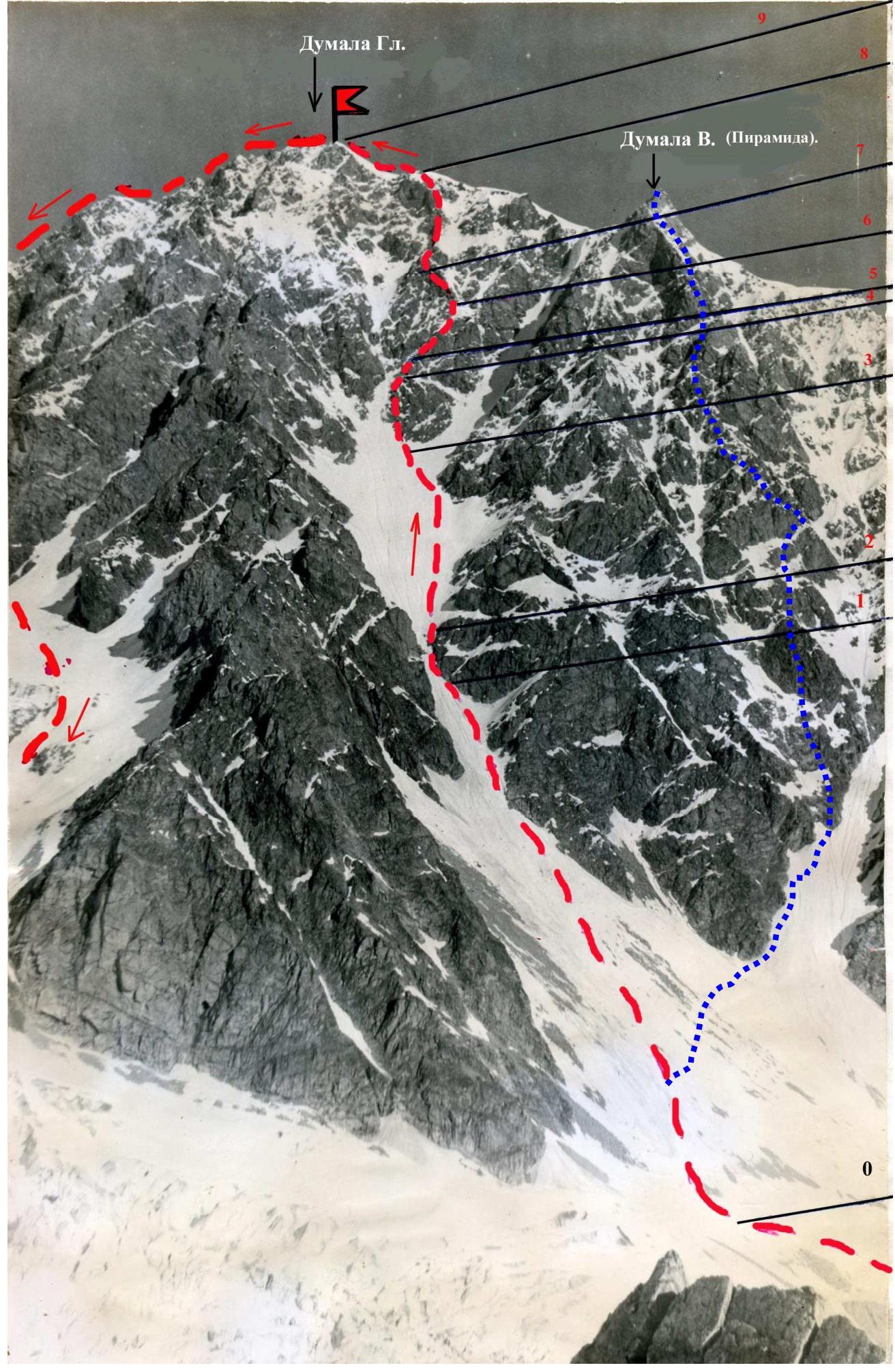
Red line — path to the main Dumala summit via the Southeast buttress. Blue line — path to Dumala East (Pyramid) via the central Southeast buttress.