ASCENT. Ascent of Peak Shota Rustaveli via the Southeastern Wall
Dedicated to the jubilee days of the great poet Shota Rustaveli
Brief Geographic Overview and Climbing History of the Ascent Area
Peak Shota Rustaveli (4960 m) is located on the Main Ridge of the Central Caucasus. To the north, Peak Rustaveli drops with huge icefalls onto the Bezengi Glacier. To the south, it towers with a rocky-icy wall over the Khalde Glacier.
Nearby on the ridge are the peaks of Eastern Jangi (5047 m) to the west and Western Shkhara to the east.
The extensive length of the walls and the significant steepness of the southern slopes make this area exceptionally interesting for challenging sport ascents. This area is relatively undeveloped. Its exploration effectively began in 1965 with the opening of the "Ailama" camp.
In 1937, a group led by Master of Sports (MS) Sandro Gvalia conquered an unnamed peak on the ridge between Jangi and Shkhara and named it Peak Shota Rustaveli.
Twenty years later, Georgian climbers under the guidance of MS G. Gulbani ascended Eastern Jangi via the southern wall (5047 m).
In 1960, Western Jangi was conquered by an expedition of the Grusalpklub led by MS O. Kharadze.
In 1965, an ascent of Central Jangi from the south was made by a team from the Central Council of the "Gantiadi" Sports Society.
The Khalde Glacier area is remote from alpine camps. Therefore, an ascent in this area requires a lengthy special expedition. To reach the village of Khalde and beyond, to the lower moraines of the Khalde Glacier, one can only travel on foot or by pack transport. The road from Mestia ends in the village of Kala. When traveling from Lower Svaneti via the village of Koruldashi, a vehicle can take you as far as the village of Ushguli. The distance from the glacier to where both roads end is about 20 km.
Climatic conditions in this area are unstable and harsh, with high precipitation.
Intense solar radiation and high daily temperature fluctuations contribute to the significant degradation of ice and rock masses.
When developing a tactical ascent plan for this area, it is necessary to consider these local characteristics.
Organization of the Ascent
The expedition was organized by the Central Council of the "Gantiadi" Sports Society. The goal was to participate in the competitive ascents of the USSR and the Georgian SSR in 1965. The ascents were planned for the Central Caucasus from the south. The expedition was based at the "Ailama" alpine camp.
In connection with the jubilee days of the genius poet Shota Rustaveli, Peak Shota Rustaveli via the southeastern rocky-icy wall was chosen as the competitive ascent for the Georgian SSR. The height difference was 1700 m.
Snow, ice, rocks, the danger of rockfall, unstable weather, and a significant relative height were the challenges that a large group (10 people) had to successfully overcome.
Training of Participants
All members of the assault group, under the guidance of Honored Master of Sports D.P. Oboladze, trained year-round (gym, skiing, rocks). Before the competitive ascent, 20-day training sessions were conducted. During this period, four peaks of the 2nd and 3rd categories of difficulty were conquered:
- Tsana — 2A category of difficulty
- Gantiadi — 3A category of difficulty
- Vakhushti — 2B category of difficulty
- Peak Okros Chardakhi — 3A category of difficulty
A general rehearsal for the entire assault group was the ascent of Namkvami peak from the Unamuso pass via the southeastern ridge (3A category of difficulty). Namkvami is located on the Central Ridge and is similar in character to Peak Shota Rustaveli.
In addition to this year's ascents, the core of the assault group had between 4 to 7 joint ascents on peaks of the highest category of difficulty, including three first ascents.
Good fitness, cohesion, and discipline were essential guarantees of successfully navigating the route.
Composition of the Assault Group
- KARTVELISHVILI Givi Irakliyevich, born 1936, 1st sports category, engaged in mountaineering since 1954. Construction engineer — leader of the assault.
- SHARASHENIDZE Dimitri Borisovich, born 1937, 1st sports category, engaged in mountaineering since 1956. Metallurgical engineer — participant.
- BAKRADZE Vissarion Georgiyevich, born 1936, 1st sports category, engaged in mountaineering since 1957. Design engineer — participant.
- BAKANIDZE Tamaz Grigoryevich, born 1937, 1st sports category, engaged in mountaineering since 1959. Artist — participant.
- VERISHVILI Tengiz Akakiyevich, born 1939, 1st sports category, engaged in mountaineering since 1959. Student — participant.
- JAPARIDZE Rostom Georgiyevich, born 1937, 1st sports category, engaged in mountaineering since 1957. Electronics engineer — participant.
- JAPARIDZE Levan Abelovich, born 1936, 1st sports category, engaged in mountaineering since 1956. Construction engineer — participant.
- SARKISOV Lev Arshakovich, born 1937, 2nd sports category, engaged in mountaineering since 1961. Technician — participant.
- AKOPYAN Lev Sergeyevich, born 1940, 2nd sports category, engaged in mountaineering since 1961. Technologist — participant.
- NANUMOV Georgy Abgarovich, born 1938, 2nd sports category, engaged in mountaineering since 1962. Technician — participant.
Peak Rustaveli
Route Description
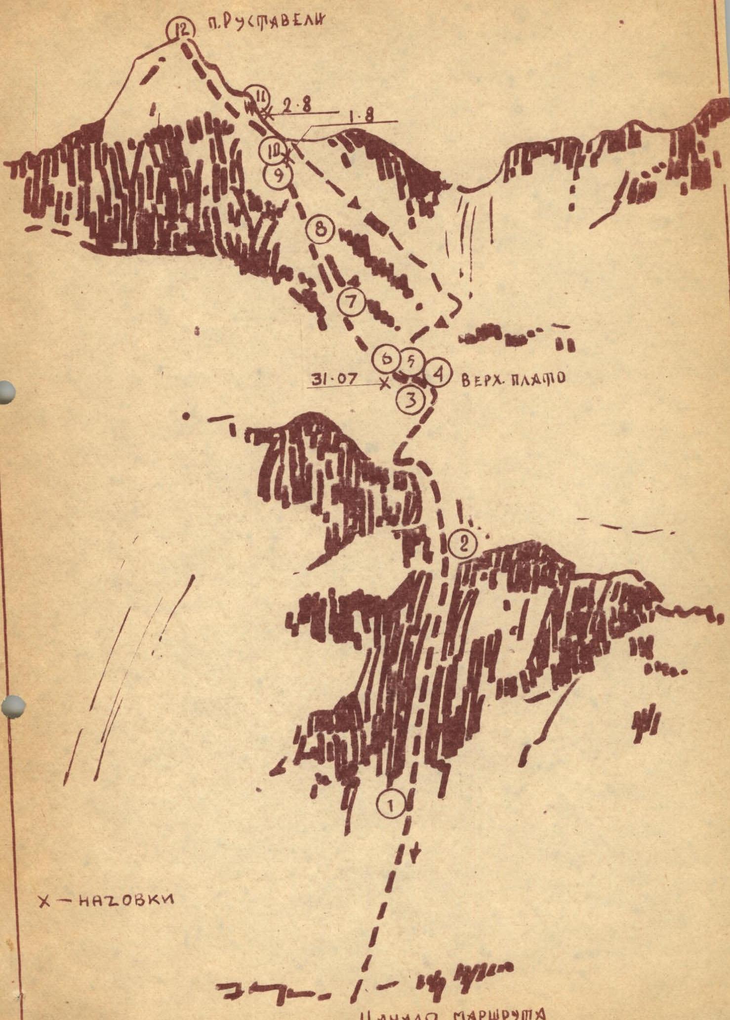
Day I. The base camp is located on the orographic right bank of the Khalde Glacier moraine at an altitude of 2600 m. The route begins from the base camp, passes along the ridge of this moraine, and, following the orographic right bank of the open Khalde Glacier, reaches (R0–R1) the rocky end of the southern counterfort of Peak Rustaveli (movement in ropes, across the glacier).
(R1–R2) Ascent via a couloir (Fig. № 1) and medium, heavily eroded rocks with a steepness of 40–45°, exit onto the southern counterfort — via a snow-ice slope (30–35°), section (R2–R3).
(R3–R4) Descent down the counterfort onto a plateau via a snowy slope (15–20°).
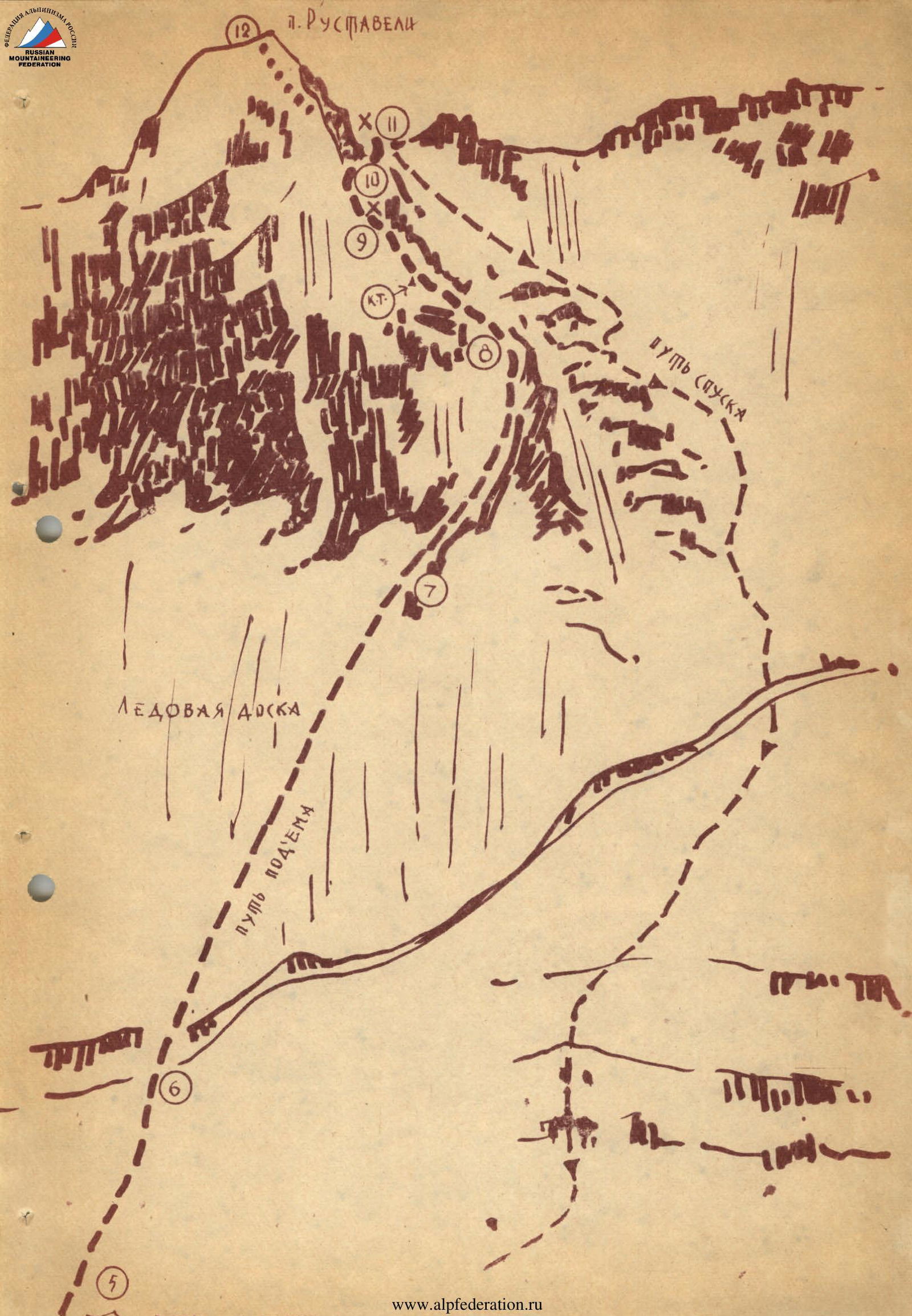
(R4–R5) Further, due to overhanging ice formations — to the right of the route — predominantly following the left part of the glacier, navigating between seracs and huge transverse crevasses, ascent via a steep icefall to the upper plateau, where a bivouac is set up on the ice. Above the bivouac, a bergschrund is visible, over which lies an ice board of significant steepness.
Day II. (R5–R6) Departure at 7:00 in the direction of the ice board towards the bergschrund via hard frozen firn in crampons. Wind. Steepness 35–40°. Belay on ice axes.
(R6–R7) Overcoming the bergschrund with the help of ice axes used as artificial points of support, very cautiously as they do not penetrate deeply into the frozen firn. Careful belay on ice axes and via the shoulder. Further ascent up the steep ice board.
Steepness 45–50°. The first climber ascends without a backpack on front points, using an ice axe as a point of support. 4 ropes, 10 hooks, and we exit onto rust-colored rocks — to the left of the dangerous ice couloir (dangerous due to rockfall and possible ice avalanches).
(R7–R8) Initially, upwards to the right (70–80 m) via rocks of medium difficulty (belay via projections and hooks). Then straight up via eroded rocks to a 15–20-meter steep wall. The first ascendant passes the wall without a backpack.
(R8–R9) Further, the average steepness of the section increases to 60°. In places, there are vertical walls up to 2.5–3.4 meters high. The rocks are icy — it's hard to find good handholds. This takes a lot of time. This section is one of the most difficult and also dangerous due to loose rocks. Fog. We set up a control cairn.
(R9–R10) Next, there is a snow-ice slope with rocky sections. The steepness decreases slightly to 50–55°. Fog rises. Continuing the ascent is risky. We look for a place for a bivouac. According to our calculations, we should have spent the night on the saddle between Western Shkhara and Peak Rustaveli, but difficult-to-pass sections took a lot of time. It will soon be dark. There's nowhere to set up tents. We organize a sitting bivouac on a rocky ledge.
Day III. (R10–R11) Since the summit is just 200 meters from our sitting bivouac, we wait until the sun warms us up and depart only at 9:00. By cutting steps, traversing the ice slope (40–45°) (Fig. № 3) and crossing the dangerous ice couloir in its uppermost part, we approach a steep snowy slope that leads us to the saddle between Peak Rustaveli and Western Shkhara.
(R11–R12) The saddle greets us with strong gusts of wind. The weather deteriorates. From the saddle, we descend to the northern side and, traversing a not-too-steep snowy slope to the left and downwards (1 rope), reach rocky outcrops. Then, after ascending a steep snowy rise (50–55°) (3 ropes), with belay on ice axes, we exit onto the summit ridge. To the left of the route, 20–30 meters away, lies the summit.
Descent to the saddle via the ascent route. The weather deteriorates completely. With great difficulty, we cut out platforms in the loose firn and somehow manage to set up 3 tents, but one collapses under the weight of snow after an hour. Thus, under hurricane-force winds, the whole day and night pass.
Day IV. In the morning, the wind is still blowing, although not as strongly as at night, and we begin our descent. From the saddle, leaving the ice couloir and rocks to the right, we descend straight down the left wall (45–50°) to the upper plateau (14 ropes). Belay is always on ice hooks.
Descent from the upper plateau follows the ascent route.

Conclusion
The route taken to Peak Shota Rustaveli via the southeastern rocky-icy wall is one of the interesting combined routes. Difficult sections on the route are located above 4000 meters above sea level.
Difficulties on the route:
- Rocks are in places extremely difficult.
- Ice boards are steep.
- Snow is loose and deep.
Features of the ascent:
- Between the upper plateau and the saddle, there are no suitable areas for bivouacs.
- There is no drinking water from the lower plateau.
The weather did not favor the ascent and did not allow for photography along the way.
On the route, one control cairn was set up, and 53 hooks were left behind, of which 24 were rock hooks and 29 were ice hooks.
There were no incidents on the route. All members of the assault group actively participated in the successful completion of the ascent.
The significant relative height, numerous challenging sections, the combined nature, and the logic of the route place it among the top routes in the 4B category of difficulty.

Table for Peak Shota Rustaveli via the Southeastern Wall. Height difference — 1700 m. Average steepness — 50°.
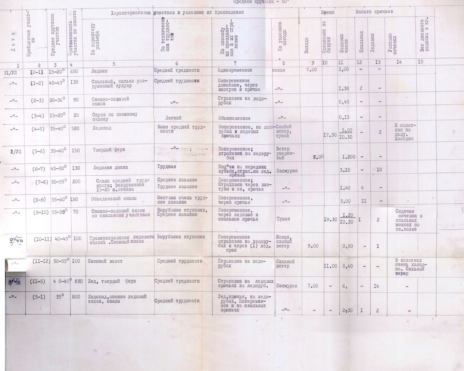
| Date | Sections Covered | Average Steepness of Section | Height of Section | Character of Relief | Characteristics of Sections and Conditions of Passage | Technical Difficulties | Method of Overcoming and Belay | Weather Conditions | Departure Time | Stop for Bivouac | Climbing Hours | Hooks Left (Rock) | Hooks Left (Ice) | Bivouac Conditions | Weight of Daily Rations in kg |
|---|---|---|---|---|---|---|---|---|---|---|---|---|---|---|---|
| R/Ush | |||||||||||||||
| Day I | |||||||||||||||
| (R0–R1) | 15–20° | 650 m | Glacier | Medium difficulty | Simultaneous | Clear | 7:00 | 3:00 | |||||||
| (R1–R2) | 40–45° | 130 m | Rocky, heavily eroded couloir | Medium difficulty | Alternating movement, via projections and hooks | 1:30 | 2 | ||||||||
| (R2–R3) | 30–35° | 90 m | Snow-ice slope | Belay on ice axes | 0:45 | ||||||||||
| (R3–R4) | 15–20° | 20 m | Descent down snowy slope | Easy | Ordinary | 0:15 | |||||||||
| (R4–R5) | 35–40° | 580 m | Icefall | Above medium difficulty | Alternating, on ice axes and ice hooks | Light wind, fog | 5:00 | 17:30 | 10:30 | 2 | In tents on ice. Cold. | ||||
| Day II | Day | ||||||||||||||
| (R5–R6) | 35–40° | 150 m | Hard firn | Alternating; belay on ice axes | Moderate wind | 8:00 | 1:20 | ||||||||
| (R6–R7) | 45–50° | 130 m | Ice board | Difficult | Ascent on front points, belay on ice hooks | Overcast | 3:10 | 10 | |||||||
| (R7–R8) | 50–55° | 200 m | Rocks of medium difficulty; eroded 15–20 m walls | Medium climbing, difficult climbing | Alternating; belay via projections and rock hooks | 1:40 | 4 | ||||||||
| (R8–R9) | 55–60° | 180 m | Icy rocks | In places very difficult climbing | Alternating, via hooks | 3:00 | 11 | ||||||||
| (R9–R10) | 50–55° | 70 m | Snow-ice slope with rocky sections | Step cutting, medium climbing | Alternating, via ice and rock hooks | Fog | 1:20 | 19:30 | 10:30 | 1 | 2 | Sitting bivouac on a rocky ledge in sleeping bags. | |||
| Day III | |||||||||||||||
| (R10–R11) | 40–45° | 100 m | Traversing ice slope, snowy slope | Step cutting | Alternating, belay on ice axes and via (1) ice hook | Clear, light wind | 9:00 | 0:50 | 1 | ||||||
| (R11–R12) | 50–55° | 100 m | Snowy ascent | Medium difficulty | Belay on ice axes | Strong wind | 11:00 | 0:40 | Very cold in tents. Strong wind. | ||||||
| Day IV | |||||||||||||||
| (R11–R5) | 40–45° | 830 m | Ice, hard firn | Medium difficulty | Belay on ice hooks and ice axes | Overcast | 7:00 | 6 | 14 | ||||||
| (R5–R1) | 35° | 800 m | Icefall, snow-ice slope, rocks | Medium difficulty | Ice hooks, on ice axes, alternating, and on rock hooks | 2:30 | 1 | 2 |