
Description of the First Ascent Route
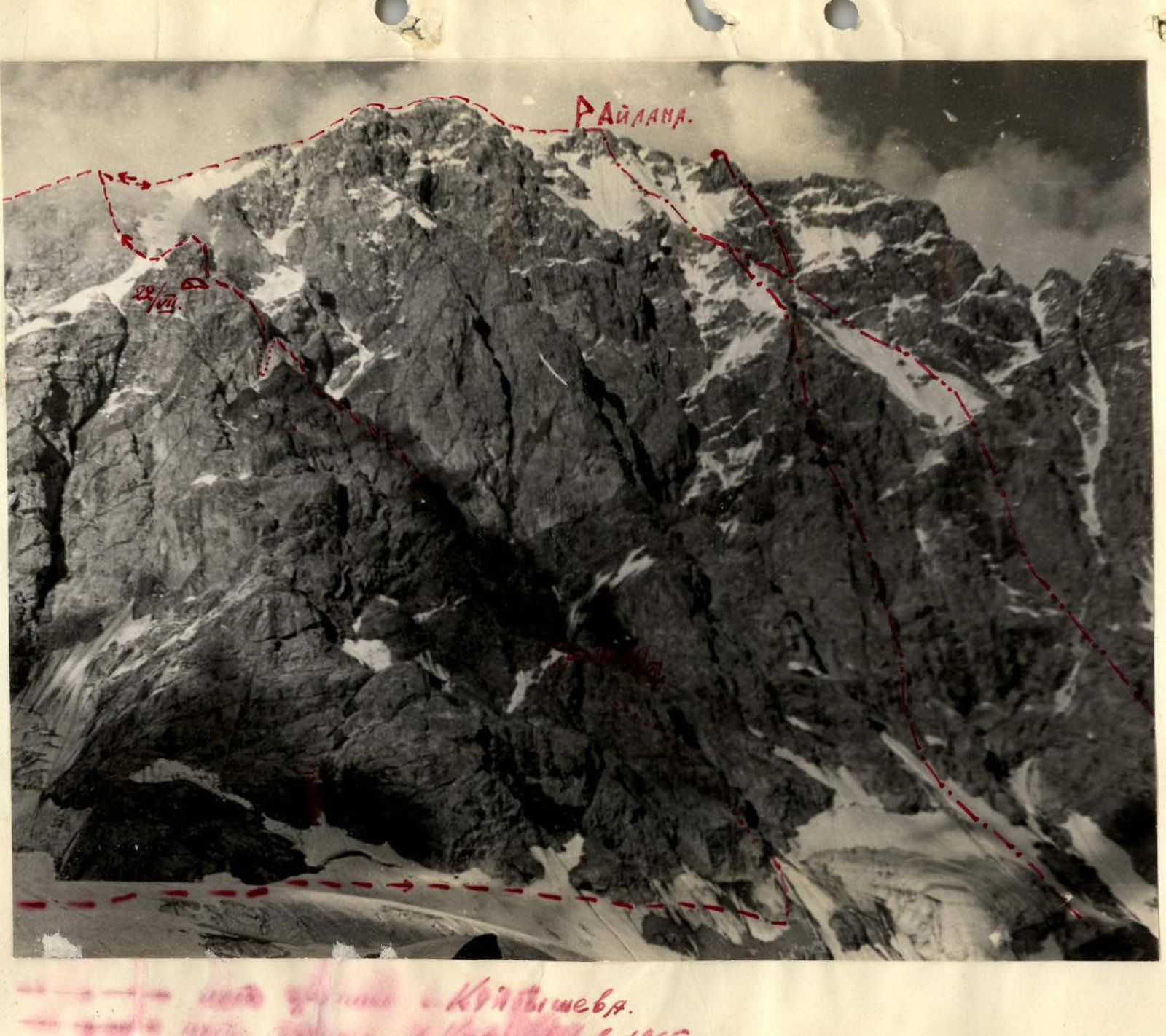
To the summit of Peak Айлама (Ailama) via the Western spur of the South wall, climbed on July 20-25, 1966, by a team from the Kuibyshev Regional Council of the "Trud" Sports Society.
Ailama is located in the Main Caucasus Range. To the west of the summit, beyond the Unamusso pass ("Бессовестный" or "Shameless"), lies Peak Нуам-Куам (Nuam-Kuam), with a ridge connecting it to the summit of Восточная Шхара (Eastern Shkhara) via peaks 4250 m and 4100 m.
Beyond the so-called "saw" of Ailama, the ridge turns south towards the summit of Цурунгал (Tsurungal), and then eastwards through peaks Черная Незнакомка (Black Stranger, пик Алеши Джапаридзе or Aliocha Djaparidze Peak) and Белая Незнакомка (White Stranger) to the Шерри–Вцек (Sherri-Vtsek) pass. The Ailama ridge stretches for a considerable distance. The western ridge has a steepness of up to 55° in its lower half and is characterized by a system of snow and ice undulations with steepness ranging from 25° to 75° in its upper part. The eastern ridge of the summit is primarily rocky and is known as the "Pила Айламы" (Ailama Saw), indicating its highly serrated nature.
Along the entire length of the massif's ridge, steep walls with significant relative heights drop to the north and south; those to the north are mostly snow and ice, while those to the south are more rocky.
Due to the remoteness of this mountain region from permanent alpine camps, until 1965, only a few sports groups, always consisting of high-class climbers, ascended Ailama. Most of these groups followed the ridge of the massif, undertaking extensive traverses of the crest.
In 1940, Е.М. Абалаков (E.M. Abalakov) and Е. Иванов (E. Ivanov) completed the traverse from Цурунгал (Tsurungal) to Айлама (Ailama) to Нуам-Куам (Nuam-Kuam). In the same year, a group led by Алеши Джапаридзе (Aliocha Djaparidze) traversed from Цурунгала (Tsurungala) to Шхара (Shkhara).
In the post-war years, the Ailama ridge was traversed three times: in 1952 by a group led by А. Немецверидзе (A. Nemetsveridze) from Цурунгала (Tsurungala) to Тетульда (Tetulda), in 1955 by a group led by И.А. Галустов (I.A. Galustov) from Каштан-Тау (Kashtan-Tau) to Цурунгала (Tsurungala), and in 1965 by a group led by М. Хергиани (M. Khergiani) from Айлама (Ailama) to Миссес-Тау (Misses-Tau).
Fewer groups have tackled the technically very challenging walls of the summit. In 1958, a duo from МВТУ (Bauman Moscow State Technical University), Осинцев (Osintsev) and Иванов (Ivanov), climbed the very interesting, primarily snow and ice, north wall of Ailama.
There are indications that the south wall of Ailama was climbed by a group led by А. Немецверидзе (A. Nemetsveridze) between 1951 and 1953, but no description of this ascent has been preserved, not even in the Georgian Club named after А. Джапаридзе (A. Djaparidze) or with the group's leader.
With the opening of the "Айламы" (Ailamy) alpine camp in 1965, it became possible to more quickly explore this most interesting region from an alpinism perspective. Naturally, the most skilled groups sought to test their strength against the beauty of Ailama.
In 1965, a duo consisting of И. Кудинов (I. Kudinov) and Ю. Козлов (Yu. Kozlov) climbed the ridge to the right of the Central South wall. The same route, with some modifications in its upper part, was later climbed by a group led by Г. Картвалишвили (G. Kartvalishvili), and a group led by Мирианишвили (Mirianiashvili) successfully ascended the very interesting and technically challenging Central South wall.
In preparation for climbing this wall, the combined team from the Kuibyshev Regional Council of the "Trud" Sports Society, consisting of:
- Бенкин В.С. (V.S. Benkin) — Master of Sports of the USSR — team leader,
- Бочков В.Н. (V.N. Bochkov) — Master of Sports of the USSR,
- Джапаридзе Г.К. (G.K. Djaparidze) — Master of Sports of the USSR,
- Леонтьев Г.В. (G.V. Leontiev) — 1st sports category,
When selecting a route for a sufficiently challenging training ascent, the team set its sights on the first ascent of the Western spur of Ailama's South wall. The group chose this route because it represented a very logical new path, and the structure of the rocks shared many similarities with their planned main route.
The spur was carefully examined during a reconnaissance trip to the Ailama plateau in early July by Бенкин (Benkin) and Бочков (Bochkov), and then again just before the ascent by Бочков (Bochkov) and Леонтьев (Leontiev) from the plateau, and by Бенкин (Benkin) during an ascent of Нуам-Куам (Nuam-Kuam).
Prior to this ascent, the team members had the following climbing experience together:
- Бенкин В. (V. Benkin) and Бочков В. (V. Bochkov) had completed 10 ascents of 4th to 5th category difficulty together since 1959, including four routes of 5Б (5B) category.
- Джапаридзе Г.К. (G.K. Djaparidze) and Бенкин В. (V. Benkin) had previously climbed six routes of 3rd to 5th category difficulty together.
- Бочков В. (V. Bochkov), Леонтьев Г. (G. Leontiev), and Бенкин В. (V. Benkin) had undertaken a joint ascent of 3Б (3B) category and regularly trained together on the rocks of Жигулёвские горы (Zhiguli Mountains).
- Бенкин В. (V. Benkin) and Леонтьев Г. (G. Leontiev) had completed the first ascent of the South wall of пик А. Джапаридзе (A. Djaparidze Peak) together in 1965 — a route of 4Б (4B) category.
The team members knew each other well from many years of working together in the mountains and at home.
The group was well-equipped with supplies and gear, bringing a tent, two down-filled sleeping bags, 4 down jackets, two main ropes of 45 m each, 5 ice screws, 20 steel and 25 various titanium pitons, 5 titanium wedges, ladders, and bolt hanger pitons.
The spur they planned to climb is primarily rocky and consists of Precambrian light grey granites. Steep, complex walls alternate with sections of broken, dark-colored rocks and sharp snow and ice crests. A little above the middle of the spur, there is a gap, after which a vertical wall rises. During reconnaissance, this gap was not identified because it was obscured by rocks of the same color from the next spur.
Description
July 19, 1966. From the "Айламы" (Ailamy) alpine camp, the path follows the trail along the right (orographically) bank of the Корулдаш (Koruldash) river to the tongue of a steep icefall falling from the plateau to the south. 150 m before reaching the icefall, the path ascends steeply upwards through deep couloirs on the slopes of пик Вахушти (Vakhushti Peak). In the lower couloirs, broken rocks with grassy ledges are overcome, while the upper couloir features a steep snowy slope. The couloir, with a steepness of up to 40–45°, leads to a broken rocky crest 50 m long, then to the right along a snowy slope onto the plateau. The journey takes 7 hours. The bivouac is set up on the plateau at an altitude of 3100 m. In the evening and at night, there is sleet, wind, and fog.
July 20. Departure from the bivouac at 9:00. Crossing the plateau follows an arc: first upwards towards the Унамуссо (Unamusso) pass, then, without reaching the slope 200 m to the right, with a gradual gain in height, to the opposite edge of the plateau (avoiding the icefall). Along steep snowy and icy slopes (steepness 40–50°) with careful belaying via ice axe and ice screws (3 screws), the group circumvents three rocky headlands (end of the spur) and enters a long snowy couloir 30–40 m wide. The steepness of the slope is 40–50°. The couloir is visible almost up to the main ridge; in its center, there is a deep groove. The right side of the couloir is formed by vertical, smooth rocky walls of a "bastion," while to the left lies a steep rocky ridge planned for ascent. From the ridge's crest, sheer walls, sometimes overhanging, drop into the couloir. A suitable exit was found 150–170 m above the start of the couloir. This is a steep (up to 65°) narrow couloir with a snowy-icy slope. The ascent to the ridge's crest goes along the right side through slopes of medium difficulty (45 m — 3 screws), then to the left across an icy slope with belay from rocks and along the slabs of the left side of the couloir (50 m — 2 screws) onto a snowy saddle on the ridge. The ascent from the plateau took 6 hours. A sharp deterioration in weather (snowfall, fog, strong wind) forced the team to set up a bivouac at 15:00.
July 21. In the morning, a thunderstorm, followed by dense fog. Visibility was 10, sometimes 20 m. During the day, sleet fell three times. The weather began to improve at 18:00.
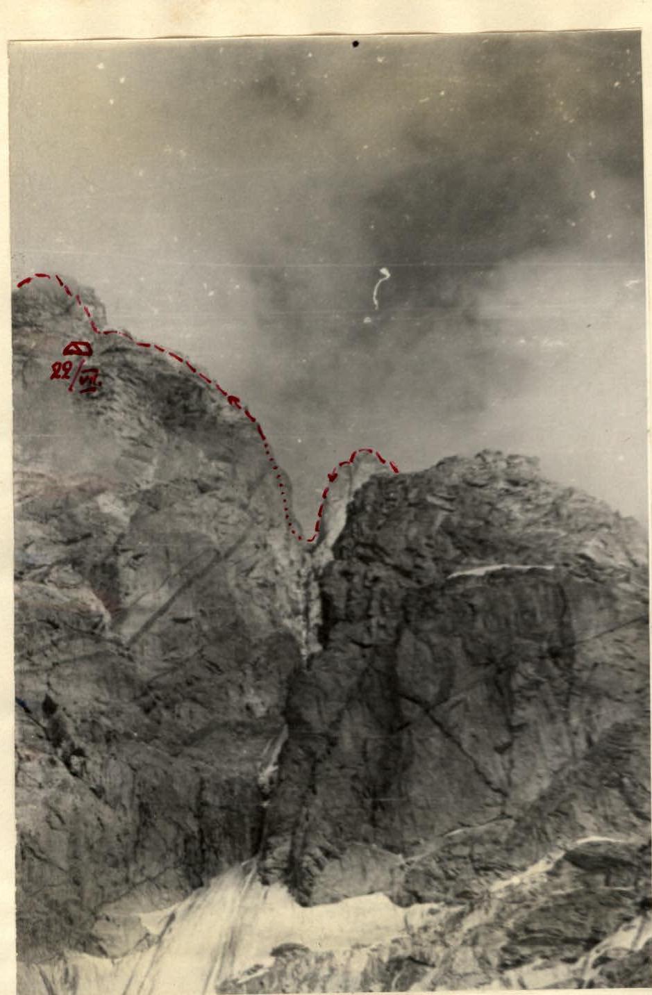
July 22. Departure at 8:00. From the bivouac, a narrow snowy ridge 20 m long continues. Movement is alternating with piton belay from rocks. Beyond the ridge, the path goes through dark rocks with alternating broken sections of no more than 45° steepness and vertical walls up to 5–7 m high, which have holds. On gentler slopes, there are many loose stones. Movement is alternating with belay through outcrops and pitons (2 pitons). This 120 m long section was covered in 1 hour 30 minutes. The ridge led to an almost sheer (75–85°) smoothed wall of greyish-yellow color. The wall is 60 m high. The first 10 m were climbed directly upwards through a poorly defined inner angle (2 pitons and one wedge), then traversed to the right along a narrow sloping ledge 12 m long under overhanging rocks — 3 pitons. The ledge leads beyond the ridge's crest. From here, the path to the ridge's crest goes through difficult, smooth rocks with a steepness of up to 75°. The cracks are wide and vertical. For belay and movement, 6 titanium wedges were hammered in over 45 m. Climbing the wall took 3 hours 30 minutes. "The wall led to a gentler section of the ridge (30–40°) 120 m long. Movement was partly simultaneous with belay through outcrops. At the end of the ridge, there is a snowy crest 10 m long, followed by a sheer, smooth wall of a gendarme 35 m high. Descending to the right down a steep snowy couloir 25 m led to a ledge; after crossing it with piton belay 6 m — 2 pitons, the group reached a steep rocky crest of the gendarme. Along a vertical inner angle 5 m long, then through difficult walls 5–6 m with narrow sloping ledges, they reached the top of the gendarme. The entire ascent of the gendarme, 60 m long, took 2 hours 30 minutes. 9 pitons were hammered in, including 3 blade pitons and two channel pitons. The terrain was difficult. From the gendarme, a descent was made by climbing down 10 m, then by rope 20 m to a three-meter snowy saddle with a cornice to the west. Beyond the saddle begins a smooth 90-meter wall. The average steepness of the wall is 80°. The first 45 m are 90°, with no bypass for the wall."
From the saddle, along an inner angle 5 m long, they reached a ledge, hammering in 2 pitons. From the ledge, a 5–7 cm wide ledge with a steepness of 50° leads upwards:
- to the left upwards for 4 m,
- then upwards to the right — for 5 m.
To the base of a sheer inner angle 10 m long. Up to the angle, 2 pitons were hammered in. Movement up the angle is directly upwards (very difficult climbing on smooth rocks without holds — on friction) to a short sloping ledge (3 pitons over 10 m). On the ledge, only one person can stand; it's impossible to accommodate a second person.
Further ascent up the sheer wall with sparse holds; another 18 m were covered. Climbing this section required the use of 6 pitons (including two channel pitons).
Above the wall lies a wide 70 cm ledge, where all backpacks were lifted because climbing the entire section of the wall from the saddle to this ledge with backpacks was impossible for all participants.
The subsequent 45 m consist of 1.5–2 meter smooth slabs with a steepness of 60° and smooth walls up to 2 m high. The terrain is very complex; sparse, narrow cracks complicate the organization of belay. 7 thin pitons were hammered in, including five blade titanium pitons. Ladders were used twice. At the top of the wall, there's a slab with a steepness of 60°. Traversing it to the left (2 pitons) led to a ridge 15 m long. Movement along the sharp crest on horseback with piton belay from the slab, then through a three-meter chimney brought the group to a broad ridge with a steepness of no more than 35°. The rocks are of medium difficulty, stretching 60–70 m. Belay is through outcrops. At the end of the ridge, under a yellow vertical wall, 20 m to the left and below the ridge, a bivouac was set up at 22:00. Climbing the 90-meter wall took 6 hours.
July 23. Departure at 8:00. Along the ridge of broken rocks — 10 m — they approach the wall. In the center, an ascent is made up a three-meter sheer wall (2 pitons in a single crack) to a sloping ledge 20 cm wide. Along the ledge, 10 m to the left upwards along the sheer wall (3 pitons) to smooth slabs with a steepness of about 60° and a length of 20 m. Movement proceeds along a wide crack; 4 titanium wedges were hammered in. The terrain is complex; climbing this 30 m wall took 2 hours.
A descent from the gendarme by climbing down (10 m) leads to a simple ridge of monolithic rocks — 45 m — followed by a forty-meter very sharp snowy ridge with a slight ascent. The snow is deep; walking along the ridge is not possible because the snow gives way with every step. Movement proceeds along the ridge after clearing it with an ice axe. Belay is from rocks. Two rocky gendarmes, 10 m and 25 m high, are bypassed to the right along rocky walls with piton belay (2 pitons each). The ascent to the ridge is made along the eastern wall of the second gendarme, 20 m long. The rocks are not very complex, though steep — 70°. Again, a sharp icy ridge, 60 m long and with a steepness of 30°. Climbing it requires clearing the ridge and careful belay via ice screws — 4 screws were hammered in. Beyond the ridge, the path goes through complex rocks about 80 m long with a steepness of 65–70°. This is a system of smooth walls 5–6 m high with few holds, narrow ledges, and steep short rocky couloirs with iced rocks. Movement is slow, with careful belay through pitons (6 pitons) and outcrops, for which the rocks had to be cleared of ice. After 6 hours 30 minutes from departure, they reached the main ridge. During the ascent to the ridge, there was again dense fog and snowy sleet. Along snowy ascents. Along the crest, they ascended to the summit in 40 minutes.
20 minutes were spent descending from the summit to the point of ascent to the ridge. A note from the group led by Картвалишвили (Kartvalishvili) dated August 23, 1965, was retrieved from the summit. At night, there was a snowy storm.
Ridge movement
July 24. Departure at 10:00. Descent using rappel down the right side of Ailama's western ridge to the saddle with a large gendarme (8 ropes), then down a long steep couloir along the rocky right side of the couloir (12 ropes of 45 m each). Further descent to the plateau followed a steep snowy slope (150 m) to the bergschrund. The bergschrund was crossed via a bridge. Descent to the plateau was completed by 17:00.
Climbing the Western spur of the South wall took the group 26 hours (from the plateau to the exit onto the main ridge). The relative height of the route (from the entrance to the couloir to the main ridge) is 1100 m — from 3200 m to 4300 m. The average steepness of the route is 55°. The most challenging sections are smooth rocky walls and slabs with a steepness of 65–90°, climbed with significant effort (walls up to 30–90 m high).
The ascent of the spur required the use of 71 pitons (including 16 channel and 12 blade pitons) and 6 ice screws on the ascent.
The group was unable to append photos of individual sections of the route to this description due to the tragic death in August 1966 of their climbing companion and friend, Master of Sports of the USSR, Джапаридзе Георгий Калистратович (Georgy Djaparidze), who was conducting photography during the ascent.
This route is considered an independent, logical, and combined, predominantly rocky path to Ailama, which, due to its technical complexity, can be recommended as an excellent training for highly qualified groups planning to climb complex southern walls in the Безенги (Bezengi) region.
The group believes that the climbed route should be classified as 5А (5A) category of difficulty.

Comments
Sign in to leave a comment